


Jeff Lindner Important update -SUN AM 7AM
Jeff Lindner Important update -SUN AM 7AM

This discussion has been locked.

Joined:
X days ago
# Posts:
X,XXX
Contributor Points:
X


Jeff Lindner Important update -SUN AM 7AM Alright guys - at 24 hours from landfall, this pretty much solidifies that we're going to have issues now that the track has shifted east of BAY City overnight and could shift even more east. â—Wind forecast for HARRIS COUNTY IS: 45-55MPH with GUSTS to 80MPH. 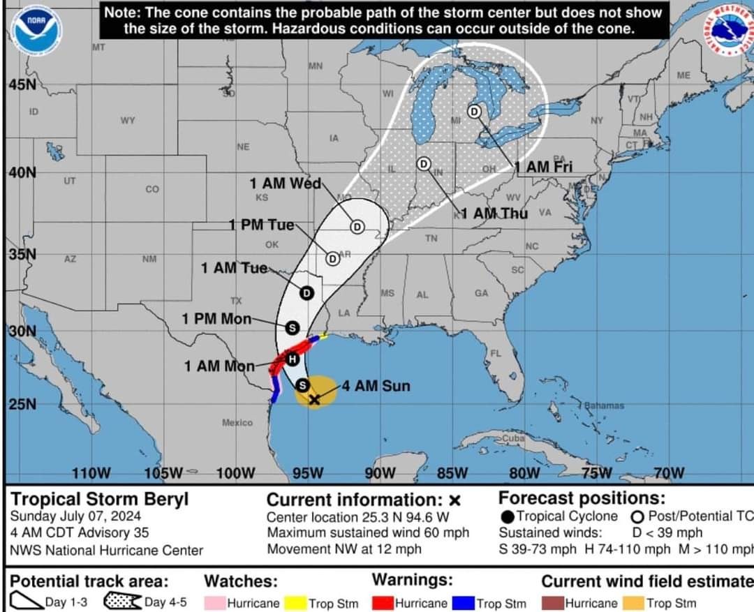 â— Finishing your preparations today and severe thunderstorm begin as early as this afternoon. *Look for a tornado watch to be issued the afternoon/evening as that will be a big threat on the dirty side, which is us. .............................. Jeff Lindner update -SUN AM 7AM. â— Preparations to protect life and property must be rushed to completion by the end of today
*Hurricane warning is extended to San Luis Pass
*Storm surge warning in effect from N Padre Island to High Island
*Slight track shifts have required to expansion of warnings and watch eastward along the TX coast and inland to INCLUDE the metro Houston area.
*Inland Hurricane Warning: Matagorda, Jackson, Calhoun, Victoria.
*Inland TS Warning: Brazoria, Galveston, Harris, Fort Bend, Colorado, Waller, Austin
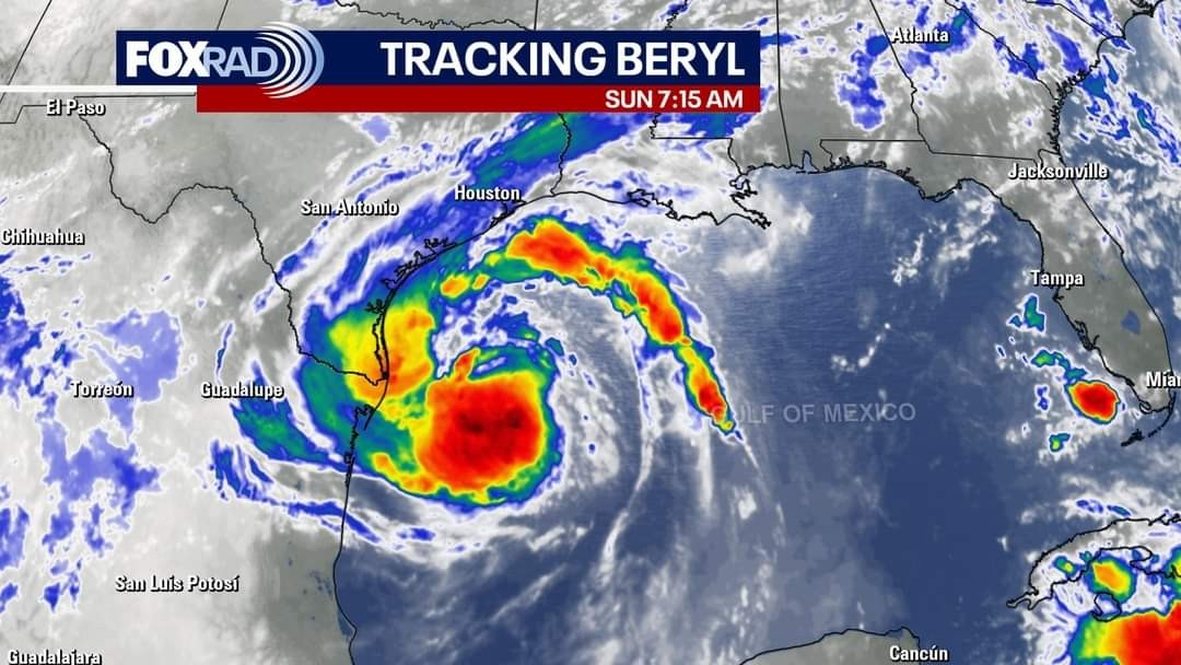
âš ï¸ Discussion: *Aircraft this morning have found that Beryl has not intensified much and Beryl is now with range of TX coastal radars which are showing a fairly well defined western side structure, but dry air continues to erode into the eastern flank of the system.
*Flight level winds of 56kt were recorded in the northeast portion of the circulation.
âš ï¸ Track/Intensity: *Beryl is starting to turn to the NW and a turn toward the NNW and N is likely today before Beryl reaches the coast.
*Overnight model guidance has shifted to the right (east) and so has the NHC track with landfall around Matagorda and some additional slight rightward track adjustments may be needed today. *Given this and the expansion of the wind field as Beryl moves northward this is requiring tropical storm and hurricane warnings to be expanded northward and eastward over SE TX and greater impacts are expected across the Houston/Galveston metro area. *After making landfall Beryl will turn toward the NNE and NE and begin to accelerate to the northeast. *Increasing forward speed and favorable upper air conditions over SE TX will help to bring stronger winds further inland over the area.
*Beryl is starting to move into more favorable conditions for development and if/when an inner core forms…more rapid intensification will be possible. ◠There remains the potential for fairly significant intensification of Beryl in the last 12 hours prior to landfall and the SHIPS intensity forecast is 2-3 times above climatology for the possibility of rapid intensification. *The NHC forecast has Beryl making landfall at 85mph…but this could be stronger and preparations should be made for a possible landfall in the range of 85-100mph+.
âš ï¸ WINDS:
*Changes overnight have required changes to the forecasted winds for much of the area.
*Tropical storm force winds will begin to arrive along the coast this evening building to hurricane conditions early Monday. 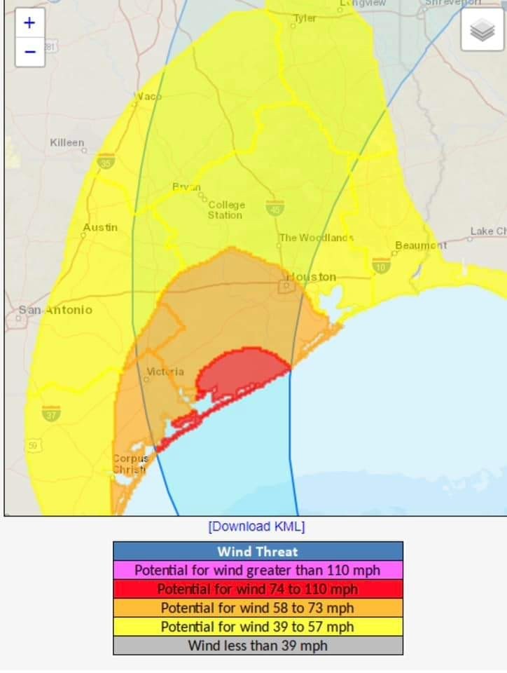 *Hurricane conditions are likely over Jackson, Matagorda and portions of Brazoria Counties and would not rule out getting hurricane conditions a bit further northward in Wharton and southern Fort Bend Counties.
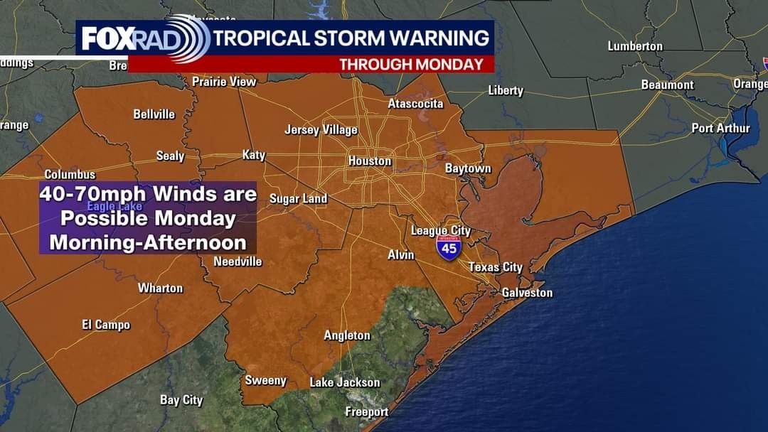
*Tropical storm conditions will expand northward much a large portion of the area on Monday generally along and south of a line from Bolivar to The Woodlands to Brenham to Columbus.
âš ï¸ FORECAST WINDS by COUNTY:
🌀Jackson: 30-40 Gusts 80
🌀Matagorda: 55-80 Gusts 100
🌀Brazoria: 45-65 Gusts 80
🌀Galveston: 35-45 Gusts 70
🌀Chambers: 30-40 Gusts 65
🌀Harris: 45-55 Gusts 80
🌀Fort Bend: 55-65 Gusts 80
🌀Austin: 35-50 Gusts 70
🌀Waller: 35-50 Gusts 75
🌀Wharton: 45-55 Gusts 80
🌀Colorado: 30-40 Gusts 60
◠Widespread power outages are now likely over a large part of the area on Monday…be prepared for extended outages.
*Downed trees and tree limbs as well as damage to roofs, windows, ect will be possible. All outdoor objects should be safely secured by this evening in the hurricane and tropical storm warning areas.
*Onset of Tropical storm force winds this evening along the coast spreading inland toward the I-10 corridor by early Monday morning and toward the HWY 105 corridor by sunrise Monday.
âš ï¸ Storm Surge:
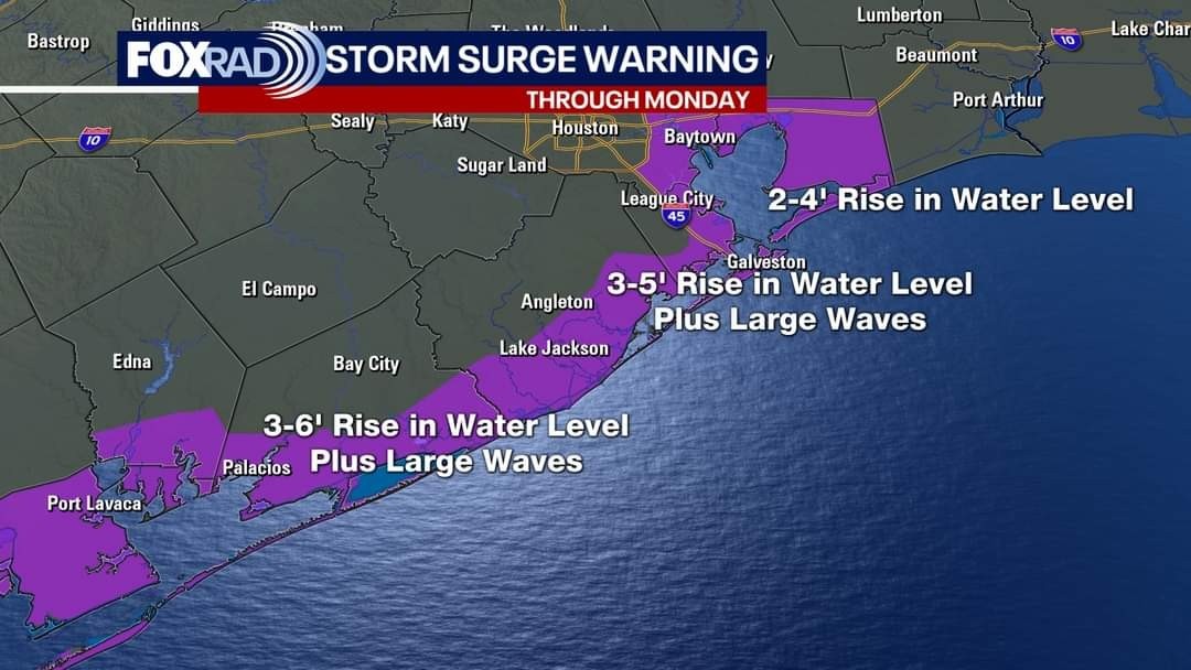
*Storm surge flooding of 4-6 ft above normally dry ground near the coast is likely from Matagorda Bay to San Luis Pass and 3-5 ft from San Luis Pass to High Island including Galveston Bay. These values have been raised 1-2 ft overnight. Low lying areas near the coast will be flooded…overtopping of bulkheads and roadways is likely as well as some dune structures. All areas flooded by Alberto will be flooded and water levels are not expected to be up to 1 foot higher than Alberto. Travel on Monday in coastal areas will be difficult including the west end of Galveston Island, Surfside, Treasure Island, Bolivar, Tiki Island, Seabrook, Kemah, Shoreacres, Sargent, Matagorda.
*Tides will begin to rise later this afternoon and peak on Monday before quickly falling late Monday into Tuesday.
*Elevated water levels will be accompanied by large waves.
*Follow all advice from local officials on any evacuation recommendations.
âš ï¸ Rainfall:
*Widespread rainfall amounts of 5-10 inches are likely along and to the right of the track of Beryl with isolated higher amounts in any banding and training.
*Corridor of heaviest rainfall looks to be along and west of I-45 on Monday…banding may continue to the south of the circulation into Monday night and possible Tuesday.
*High rainfall rates in bands will produce urban flooding and rapid rises on area creeks and bayous. 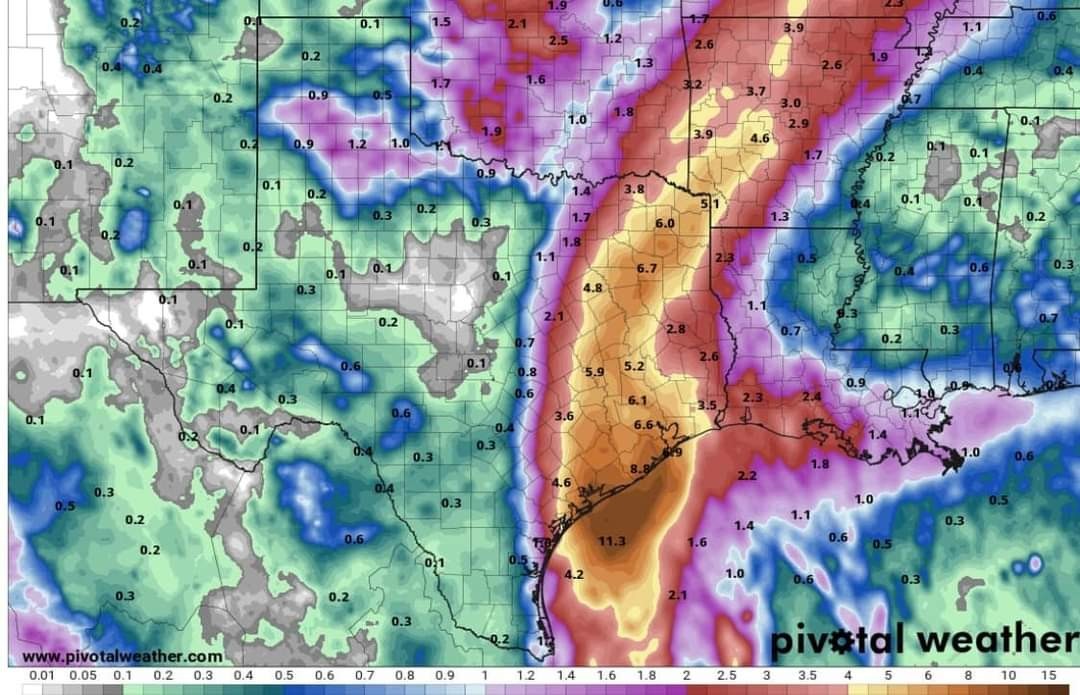 *Some flooding of creeks, bayous and rivers will be possible with the forecasted rainfall.
*River responses will continue into mid to late week.


*Hurricane warning is extended to San Luis Pass
*Storm surge warning in effect from N Padre Island to High Island
*Slight track shifts have required to expansion of warnings and watch eastward along the TX coast and inland to INCLUDE the metro Houston area.
*Inland Hurricane Warning: Matagorda, Jackson, Calhoun, Victoria.
*Inland TS Warning: Brazoria, Galveston, Harris, Fort Bend, Colorado, Waller, Austin
âš ï¸ Discussion:
*Flight level winds of 56kt were recorded in the northeast portion of the circulation.
âš ï¸ Track/Intensity:
*Overnight model guidance has shifted to the right (east) and so has the NHC track with landfall around Matagorda and some additional slight rightward track adjustments may be needed today.
*Beryl is starting to move into more favorable conditions for development and if/when an inner core forms…more rapid intensification will be possible.
âš ï¸ WINDS:
*Changes overnight have required changes to the forecasted winds for much of the area.
*Tropical storm force winds will begin to arrive along the coast this evening building to hurricane conditions early Monday.
*Tropical storm conditions will expand northward much a large portion of the area on Monday generally along and south of a line from Bolivar to The Woodlands to Brenham to Columbus.
âš ï¸ FORECAST WINDS by COUNTY:
🌀Jackson: 30-40 Gusts 80
🌀Matagorda: 55-80 Gusts 100
🌀Brazoria: 45-65 Gusts 80
🌀Galveston: 35-45 Gusts 70
🌀Chambers: 30-40 Gusts 65
🌀Harris: 45-55 Gusts 80
🌀Fort Bend: 55-65 Gusts 80
🌀Austin: 35-50 Gusts 70
🌀Waller: 35-50 Gusts 75
🌀Wharton: 45-55 Gusts 80
🌀Colorado: 30-40 Gusts 60
◠Widespread power outages are now likely over a large part of the area on Monday…be prepared for extended outages.
*Downed trees and tree limbs as well as damage to roofs, windows, ect will be possible. All outdoor objects should be safely secured by this evening in the hurricane and tropical storm warning areas.
*Onset of Tropical storm force winds this evening along the coast spreading inland toward the I-10 corridor by early Monday morning and toward the HWY 105 corridor by sunrise Monday.
âš ï¸ Storm Surge:
*Storm surge flooding of 4-6 ft above normally dry ground near the coast is likely from Matagorda Bay to San Luis Pass and 3-5 ft from San Luis Pass to High Island including Galveston Bay. These values have been raised 1-2 ft overnight. Low lying areas near the coast will be flooded…overtopping of bulkheads and roadways is likely as well as some dune structures. All areas flooded by Alberto will be flooded and water levels are not expected to be up to 1 foot higher than Alberto. Travel on Monday in coastal areas will be difficult including the west end of Galveston Island, Surfside, Treasure Island, Bolivar, Tiki Island, Seabrook, Kemah, Shoreacres, Sargent, Matagorda.
*Tides will begin to rise later this afternoon and peak on Monday before quickly falling late Monday into Tuesday.
*Elevated water levels will be accompanied by large waves.
*Follow all advice from local officials on any evacuation recommendations.
âš ï¸ Rainfall:
*Widespread rainfall amounts of 5-10 inches are likely along and to the right of the track of Beryl with isolated higher amounts in any banding and training.
*Corridor of heaviest rainfall looks to be along and west of I-45 on Monday…banding may continue to the south of the circulation into Monday night and possible Tuesday.
*High rainfall rates in bands will produce urban flooding and rapid rises on area creeks and bayous.
*River responses will continue into mid to late week.
Discussion Summary:
Jeff Lindner Issues Urgent Hurricane Update for SE Texas - Prepare for Severe Winds, Storm Surge, and Heavy Rain!
Jeff Lindner Issues Urgent Hurricane Update for SE Texas - Prepare for Severe Winds, Storm Surge, and Heavy Rain!
Discussion Insights:
Ask a question about this discussion and an AI bot will try to give an answer.
Ask a question about this discussion and an AI bot will try to give an answer.
Replies:
Thank you for the update- I'm sure you are exhausted. Good luck everyone - stay safe!!

Jeff Lindner Important update -SUN AM 7AM Alright guys - at 24 hours from landfall, this pretty much solidifies that we're going to have issues now that the track has shifted east of BAY City overnight and could shift even more east. â—Wind forecast for HARRIS COUNTY IS: 45-55MPH with GUSTS to 80MPH. â— Finishing your preparations today and severe thunderstorm begin as early as this afternoon. *Look for a tornado watch to be issued the afternoon/evening as that will be a big threat on the dirty side, which is us. .............................. Jeff Lindner update -SUN AM 7AM. â— Preparations to protect life and property must be rushed to completion by the end of today
*Hurricane warning is extended to San Luis Pass
*Storm surge warning in effect from N Padre Island to High Island
*Slight track shifts have required to expansion of warnings and watch eastward along the TX coast and inland to INCLUDE the metro Houston area.
*Inland Hurricane Warning: Matagorda, Jackson, Calhoun, Victoria.
*Inland TS Warning: Brazoria, Galveston, Harris, Fort Bend, Colorado, Waller, Austin
âš ï¸ Discussion: *Aircraft this morning have found that Beryl has not intensified much and Beryl is now with range of TX coastal radars which are showing a fairly well defined western side structure, but dry air continues to erode into the eastern flank of the system.
*Flight level winds of 56kt were recorded in the northeast portion of the circulation.
âš ï¸ Track/Intensity: *Beryl is starting to turn to the NW and a turn toward the NNW and N is likely today before Beryl reaches the coast.
*Overnight model guidance has shifted to the right (east) and so has the NHC track with landfall around Matagorda and some additional slight rightward track adjustments may be needed today. *Given this and the expansion of the wind field as Beryl moves northward this is requiring tropical storm and hurricane warnings to be expanded northward and eastward over SE TX and greater impacts are expected across the Houston/Galveston metro area. *After making landfall Beryl will turn toward the NNE and NE and begin to accelerate to the northeast. *Increasing forward speed and favorable upper air conditions over SE TX will help to bring stronger winds further inland over the area.
*Beryl is starting to move into more favorable conditions for development and if/when an inner core forms…more rapid intensification will be possible. ◠There remains the potential for fairly significant intensification of Beryl in the last 12 hours prior to landfall and the SHIPS intensity forecast is 2-3 times above climatology for the possibility of rapid intensification. *The NHC forecast has Beryl making landfall at 85mph…but this could be stronger and preparations should be made for a possible landfall in the range of 85-100mph+.
âš ï¸ WINDS:
*Changes overnight have required changes to the forecasted winds for much of the area.
*Tropical storm force winds will begin to arrive along the coast this evening building to hurricane conditions early Monday. *Hurricane conditions are likely over Jackson, Matagorda and portions of Brazoria Counties and would not rule out getting hurricane conditions a bit further northward in Wharton and southern Fort Bend Counties.
*Tropical storm conditions will expand northward much a large portion of the area on Monday generally along and south of a line from Bolivar to The Woodlands to Brenham to Columbus.
âš ï¸ FORECAST WINDS by COUNTY:
🌀Jackson: 30-40 Gusts 80
🌀Matagorda: 55-80 Gusts 100
🌀Brazoria: 45-65 Gusts 80
🌀Galveston: 35-45 Gusts 70
🌀Chambers: 30-40 Gusts 65
🌀Harris: 45-55 Gusts 80
🌀Fort Bend: 55-65 Gusts 80
🌀Austin: 35-50 Gusts 70
🌀Waller: 35-50 Gusts 75
🌀Wharton: 45-55 Gusts 80
🌀Colorado: 30-40 Gusts 60
◠Widespread power outages are now likely over a large part of the area on Monday…be prepared for extended outages.
*Downed trees and tree limbs as well as damage to roofs, windows, ect will be possible. All outdoor objects should be safely secured by this evening in the hurricane and tropical storm warning areas.
*Onset of Tropical storm force winds this evening along the coast spreading inland toward the I-10 corridor by early Monday morning and toward the HWY 105 corridor by sunrise Monday.
âš ï¸ Storm Surge:
*Storm surge flooding of 4-6 ft above normally dry ground near the coast is likely from Matagorda Bay to San Luis Pass and 3-5 ft from San Luis Pass to High Island including Galveston Bay. These values have been raised 1-2 ft overnight. Low lying areas near the coast will be flooded…overtopping of bulkheads and roadways is likely as well as some dune structures. All areas flooded by Alberto will be flooded and water levels are not expected to be up to 1 foot higher than Alberto. Travel on Monday in coastal areas will be difficult including the west end of Galveston Island, Surfside, Treasure Island, Bolivar, Tiki Island, Seabrook, Kemah, Shoreacres, Sargent, Matagorda.
*Tides will begin to rise later this afternoon and peak on Monday before quickly falling late Monday into Tuesday.
*Elevated water levels will be accompanied by large waves.
*Follow all advice from local officials on any evacuation recommendations.
âš ï¸ Rainfall:
*Widespread rainfall amounts of 5-10 inches are likely along and to the right of the track of Beryl with isolated higher amounts in any banding and training.
*Corridor of heaviest rainfall looks to be along and west of I-45 on Monday…banding may continue to the south of the circulation into Monday night and possible Tuesday.
*High rainfall rates in bands will produce urban flooding and rapid rises on area creeks and bayous. *Some flooding of creeks, bayous and rivers will be possible with the forecasted rainfall.
*River responses will continue into mid to late week.
*Hurricane warning is extended to San Luis Pass
*Storm surge warning in effect from N Padre Island to High Island
*Slight track shifts have required to expansion of warnings and watch eastward along the TX coast and inland to INCLUDE the metro Houston area.
*Inland Hurricane Warning: Matagorda, Jackson, Calhoun, Victoria.
*Inland TS Warning: Brazoria, Galveston, Harris, Fort Bend, Colorado, Waller, Austin
âš ï¸ Discussion:
*Flight level winds of 56kt were recorded in the northeast portion of the circulation.
âš ï¸ Track/Intensity:
*Overnight model guidance has shifted to the right (east) and so has the NHC track with landfall around Matagorda and some additional slight rightward track adjustments may be needed today.
*Beryl is starting to move into more favorable conditions for development and if/when an inner core forms…more rapid intensification will be possible.
âš ï¸ WINDS:
*Changes overnight have required changes to the forecasted winds for much of the area.
*Tropical storm force winds will begin to arrive along the coast this evening building to hurricane conditions early Monday.
*Tropical storm conditions will expand northward much a large portion of the area on Monday generally along and south of a line from Bolivar to The Woodlands to Brenham to Columbus.
âš ï¸ FORECAST WINDS by COUNTY:
🌀Jackson: 30-40 Gusts 80
🌀Matagorda: 55-80 Gusts 100
🌀Brazoria: 45-65 Gusts 80
🌀Galveston: 35-45 Gusts 70
🌀Chambers: 30-40 Gusts 65
🌀Harris: 45-55 Gusts 80
🌀Fort Bend: 55-65 Gusts 80
🌀Austin: 35-50 Gusts 70
🌀Waller: 35-50 Gusts 75
🌀Wharton: 45-55 Gusts 80
🌀Colorado: 30-40 Gusts 60
◠Widespread power outages are now likely over a large part of the area on Monday…be prepared for extended outages.
*Downed trees and tree limbs as well as damage to roofs, windows, ect will be possible. All outdoor objects should be safely secured by this evening in the hurricane and tropical storm warning areas.
*Onset of Tropical storm force winds this evening along the coast spreading inland toward the I-10 corridor by early Monday morning and toward the HWY 105 corridor by sunrise Monday.
âš ï¸ Storm Surge:
*Storm surge flooding of 4-6 ft above normally dry ground near the coast is likely from Matagorda Bay to San Luis Pass and 3-5 ft from San Luis Pass to High Island including Galveston Bay. These values have been raised 1-2 ft overnight. Low lying areas near the coast will be flooded…overtopping of bulkheads and roadways is likely as well as some dune structures. All areas flooded by Alberto will be flooded and water levels are not expected to be up to 1 foot higher than Alberto. Travel on Monday in coastal areas will be difficult including the west end of Galveston Island, Surfside, Treasure Island, Bolivar, Tiki Island, Seabrook, Kemah, Shoreacres, Sargent, Matagorda.
*Tides will begin to rise later this afternoon and peak on Monday before quickly falling late Monday into Tuesday.
*Elevated water levels will be accompanied by large waves.
*Follow all advice from local officials on any evacuation recommendations.
âš ï¸ Rainfall:
*Widespread rainfall amounts of 5-10 inches are likely along and to the right of the track of Beryl with isolated higher amounts in any banding and training.
*Corridor of heaviest rainfall looks to be along and west of I-45 on Monday…banding may continue to the south of the circulation into Monday night and possible Tuesday.
*High rainfall rates in bands will produce urban flooding and rapid rises on area creeks and bayous.
*River responses will continue into mid to late week.
 Mimilane tipped StormChaser 1000 credits for a post in this forum discussion.

|
Jeff Lindner Important update -SUN AM 7AM Alright guys - at 24 hours from landfall, this pretty much solidifies that we're going to have issues now that the track has shifted east of BAY City overnight and could shift even more east. â—Wind forecast for HARRIS COUNTY IS: 45-55MPH with GUSTS to 80MPH. â— Finishing your preparations today and severe thunderstorm begin as early as this afternoon. *Look for a tornado watch to be issued the afternoon/evening as that will be a big threat on the dirty side, which is us. .............................. Jeff Lindner update -SUN AM 7AM. â— Preparations to protect life and property must be rushed to completion by the end of today *Hurricane warning is extended to San Luis Pass *Storm surge warning in effect from N Padre Island to High Island *Slight track shifts have required to expansion of warnings and watch eastward along the TX coast and inland to INCLUDE the metro Houston area. *Inland Hurricane Warning: Matagorda, Jackson, Calhoun, Victoria. *Inland TS Warning: Brazoria, Galveston, Harris, Fort Bend, Colorado, Waller, Austin âš ï¸ Discussion: *Aircraft this morning have found that Beryl has not intensified much and Beryl is now with range of TX coastal radars which are showing a fairly well defined western side structure, but dry air continues to erode into the eastern flank of the system. *Flight level winds of 56kt were recorded in the northeast portion of the circulation. âš ï¸ Track/Intensity: *Beryl is starting to turn to the NW and a turn toward the NNW and N is likely today before Beryl reaches the coast. *Overnight model guidance has shifted to the right (east) and so has the NHC track with landfall around Matagorda and some additional slight rightward track adjustments may be needed today. *Given this and the expansion of the wind field as Beryl moves northward this is requiring tropical storm and hurricane warnings to be expanded northward and eastward over SE TX and greater impacts are expected across the Houston/Galveston metro area. *After making landfall Beryl will turn toward the NNE and NE and begin to accelerate to the northeast. *Increasing forward speed and favorable upper air conditions over SE TX will help to bring stronger winds further inland over the area. *Beryl is starting to move into more favorable conditions for development and if/when an inner core forms…more rapid intensification will be possible. â— There remains the potential for fairly significant intensification of Beryl in the last 12 hours prior to landfall and the SHIPS intensity forecast is 2-3 times above climatology for the possibility of rapid intensification. *The NHC forecast has Beryl making landfall at 85mph…but this could be stronger and preparations should be made for a possible landfall in the range of 85-100mph+. âš ï¸ WINDS: *Changes overnight have required changes to the forecasted winds for much of the area. *Tropical storm force winds will begin to arrive along the coast this evening building to hurricane conditions early Monday. *Hurricane conditions are likely over Jackson, Matagorda and portions of Brazoria Counties and would not rule out getting hurricane conditions a bit further northward in Wharton and southern Fort Bend Counties. *Tropical storm conditions will expand northward much a large portion of the area on Monday generally along and south of a line from Bolivar to The Woodlands to Brenham to Columbus. âš ï¸ FORECAST WINDS by COUNTY: 🌀Jackson: 30-40 Gusts 80 🌀Matagorda: 55-80 Gusts 100 🌀Brazoria: 45-65 Gusts 80 🌀Galveston: 35-45 Gusts 70 🌀Chambers: 30-40 Gusts 65 🌀Harris: 45-55 Gusts 80 🌀Fort Bend: 55-65 Gusts 80 🌀Austin: 35-50 Gusts 70 🌀Waller: 35-50 Gusts 75 🌀Wharton: 45-55 Gusts 80 🌀Colorado: 30-40 Gusts 60 â— Widespread power outages are now likely over a large part of the area on Monday…be prepared for extended outages. *Downed trees and tree limbs as well as damage to roofs, windows, ect will be possible. All outdoor objects should be safely secured by this evening in the hurricane and tropical storm warning areas. *Onset of Tropical storm force winds this evening along the coast spreading inland toward the I-10 corridor by early Monday morning and toward the HWY 105 corridor by sunrise Monday. âš ï¸ Storm Surge: *Storm surge flooding of 4-6 ft above normally dry ground near the coast is likely from Matagorda Bay to San Luis Pass and 3-5 ft from San Luis Pass to High Island including Galveston Bay. These values have been raised 1-2 ft overnight. Low lying areas near the coast will be flooded…overtopping of bulkheads and roadways is likely as well as some dune structures. All areas flooded by Alberto will be flooded and water levels are not expected to be up to 1 foot higher than Alberto. Travel on Monday in coastal areas will be difficult including the west end of Galveston Island, Surfside, Treasure Island, Bolivar, Tiki Island, Seabrook, Kemah, Shoreacres, Sargent, Matagorda. *Tides will begin to rise later this afternoon and peak on Monday before quickly falling late Monday into Tuesday. *Elevated water levels will be accompanied by large waves. *Follow all advice from local officials on any evacuation recommendations. âš ï¸ Rainfall: *Widespread rainfall amounts of 5-10 inches are likely along and to the right of the track of Beryl with isolated higher amounts in any banding and training. *Corridor of heaviest rainfall looks to be along and west of I-45 on Monday…banding may continue to the south of the circulation into Monday night and possible Tuesday. *High rainfall rates in bands will produce urban flooding and rapid rises on area creeks and bayous. *Some flooding of creeks, bayous and rivers will be possible with the forecasted rainfall. *River responses will continue into mid to late week.
StormChaser : Thank you. Going to finish bringing in the patio furniture.
|
|
7am Beryl Update: *Although Beryl is still a tropical storm, the latest hurricane hunter data shows a drop in its pressure from 992 millibars to 988. Lower pressure will eventually lead to higher winds, so it still looks like a category 1 hurricane with a landfall near Matagorda early tomorrow morning. See my previous post for more details, but prepare for a very windy and rainy 12-15 hours or so from overnight tonight through tomorrow afternoon. Winds of 50 mph and higher, heavy rain and coastal flooding. Expect the power to go out in many locations. 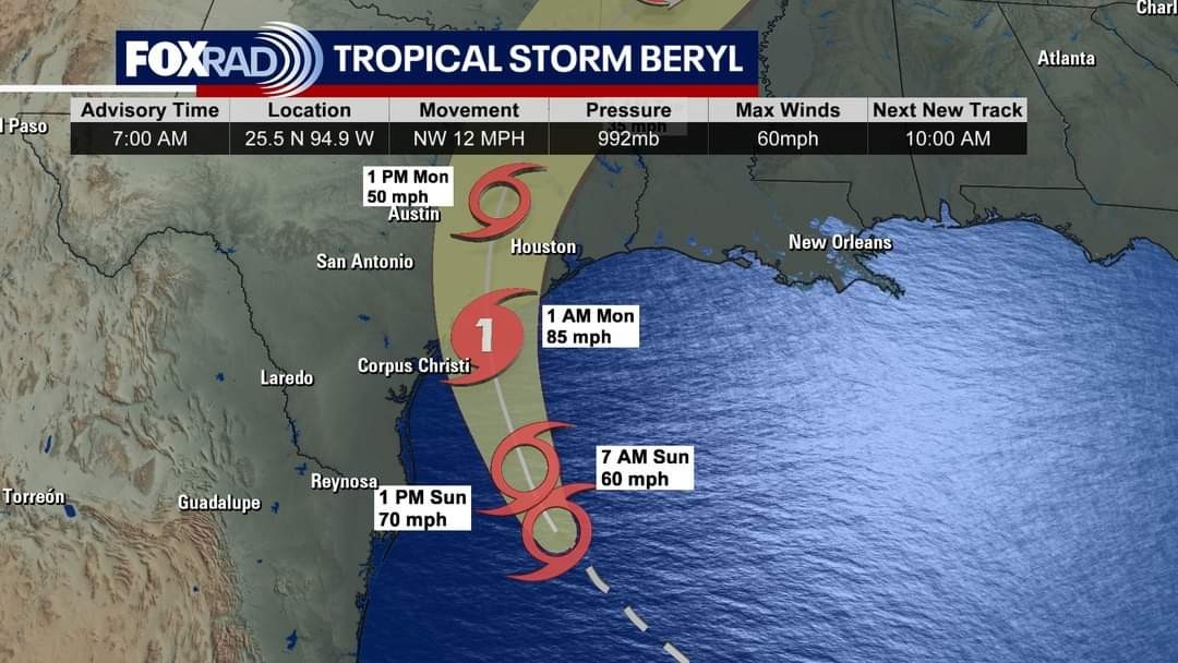
This discussion has been locked.
« Back to ChatViews: 1,256
# Replies: 5