


Tropics update Sat AM
Tropics update Sat AM

This discussion has been locked.

Joined:
X days ago
# Posts:
X,XXX
Contributor Points:
X


Tropics update Sat AM Though far too early for landfall predictions, Beryl will be one for us to watch (the entire Gulf) which also includes anywhere from the TX/MX border all way to Florida southern Florida. From The Eyewall (Space City Weather) Beryl is on its way to hurricane intensity as it moves toward the Windward Islands. June 29, 2024 at 9:19 am by Matt Lanza Headlines:
*As expected, Invest 95L is now TROPICAL STORM BERYL.
*Beryl is expected to become a hurricane as it moves into the Windward Islands Sunday night and Monday.
*Beryl has the potential to become a major hurricane as it moves into the Caribbean, feasting on water more typical of August or September than June or July.
*Hurricane impacts are likely for Barbados and the islands south of Martinique.
*Interests in Jamaica, southern Hispaniola, and the rest of the western Caribbean should monitor Beryl's progress closely. â— It is simply too soon to say anything coherently about the U.S. Gulf Coast or Mexico impacts from Beryl, if any at all.  *As expected, Invest 95L is now TROPICAL STORM BERYL. *It is expected to become a hurricane as it moves through the Windward Islands and into the Caribbean by Monday.
*From there, confidence in track decreases a good bit and interests in the western Caribbean, including Jamaica should monitor Beryl's progress over the next few days. BERYL'S INTENSITY *The center is still skewed to the eastern half of the thunderstorm activity, meaning it's not quite *well* organized yet but It's trending in that direction. Look for Beryl to become a more buttoned up tropical storm later today. 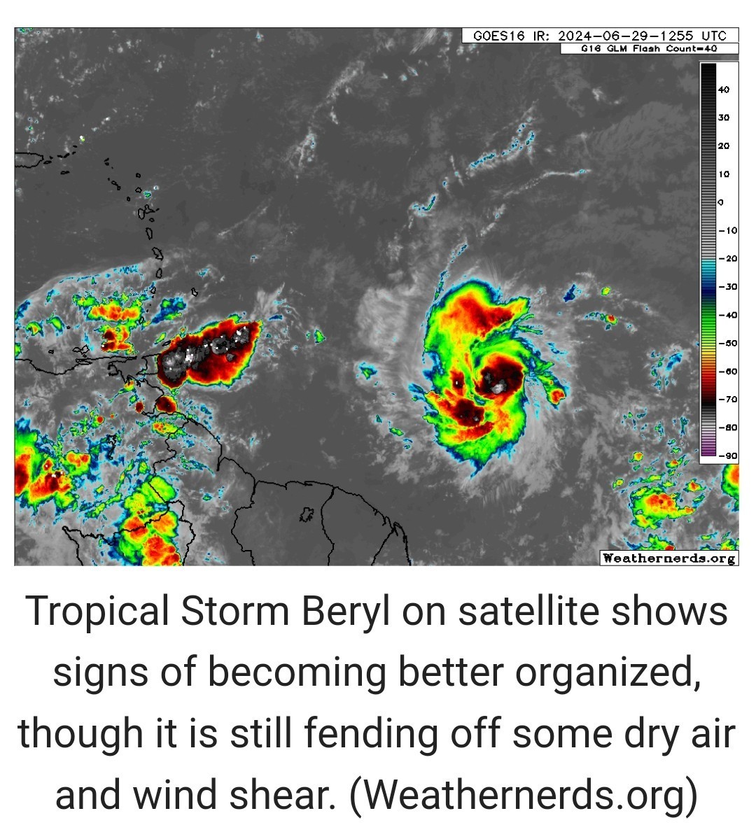
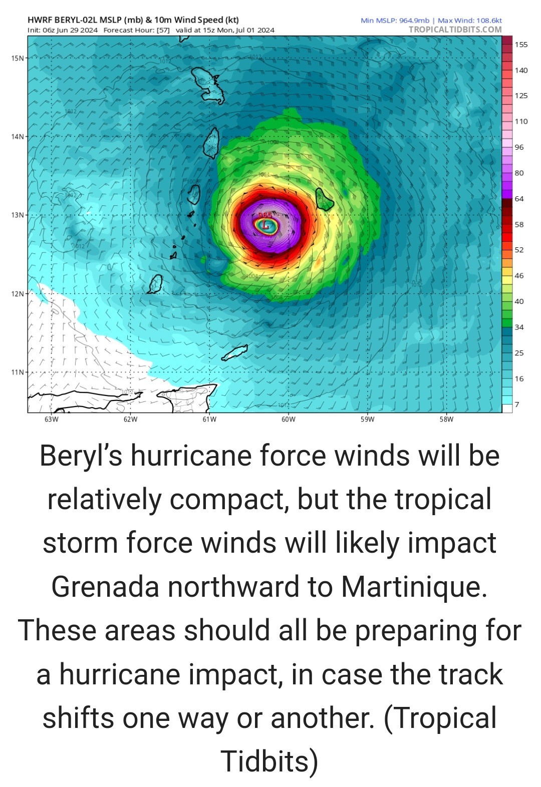 *From here, we have an almost UNANIMOUS model agreement that Beryl will strengthen as it comes west toward the Windward Islands.
*It arrives in about 48 hours, and the model probabilities of strong intensification are extremely high.
*The National Hurricane Center describes Beryl's environment as "abnormally favorable" for intensification. *This is precisely what we were concerned about coming into this hurricane season, as water temperatures in the Atlantic Main Development Region are at record levels.
*They're at records in the Caribbean too. *Beryl is in an environment that's more August than June. 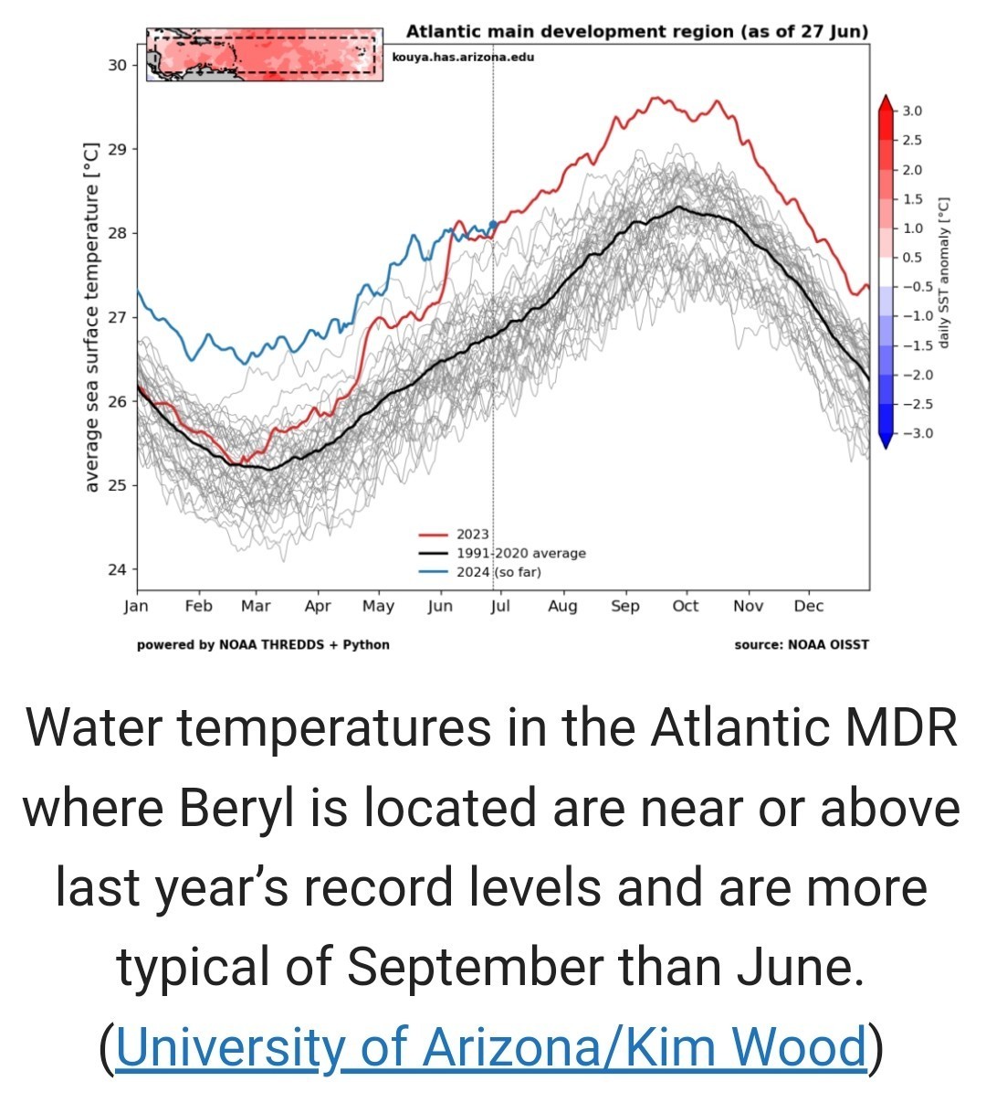 *The official NHC forecast brings Beryl to higher end Category 2 intensity by the time it cuts across the Windward Islands and into the Caribbean, and there is legitimate risk that this forecast is TOO conservative. *We're in uncharted territory* BERYL'S TRACK *As noted above, a lot of Beryl's track may depend on its intensity, with a stronger storm "feeling" troughing near Bermuda and being tugged northward, while a weaker or more disorganized storm may track more westerly or west-northwesterly across the Caribbean.
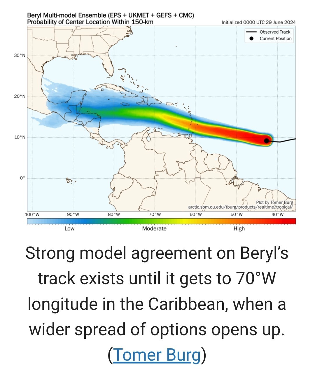 *The map above shows the probability of Beryl's track being within 150 km of a given point.
*You can see that model agreement is extremely strong as Beryl passes the Windward Islands.
*Once it gets into the Caribbean, confidence diminishes a good bit until it drops to low confidence in the western Caribbean.
*I think it's obvious that tracks toward southern Hispaniola, Jamaica, and elsewhere are very much on the table, and the current forecast cone from the NHC captures this very well. *For folks on the U.S. Gulf Coast or in Mexico and the Yucatan, it's simply too soon to really say a lot about this. There's no real signal in the noise that we can meaningfully derive from the current model guidance. ◠YES, it seems a track to the south of the Gulf is generally favored right now, but there is a high degree of uncertainty beyond day 5 on where this goes, in addition to the uncertainty on its intensity.
Keep monitoring for now, but we're still a few days from being able to say something coherently. theeyewall.com/


*As expected, Invest 95L is now TROPICAL STORM BERYL.
*Beryl is expected to become a hurricane as it moves into the Windward Islands Sunday night and Monday.
*Beryl has the potential to become a major hurricane as it moves into the Caribbean, feasting on water more typical of August or September than June or July.
*Hurricane impacts are likely for Barbados and the islands south of Martinique.
*Interests in Jamaica, southern Hispaniola, and the rest of the western Caribbean should monitor Beryl's progress closely.
*From there, confidence in track decreases a good bit and interests in the western Caribbean, including Jamaica should monitor Beryl's progress over the next few days.
*It arrives in about 48 hours, and the model probabilities of strong intensification are extremely high.
*The National Hurricane Center describes Beryl's environment as "abnormally favorable" for intensification. *This is precisely what we were concerned about coming into this hurricane season, as water temperatures in the Atlantic Main Development Region are at record levels.
*They're at records in the Caribbean too.
*You can see that model agreement is extremely strong as Beryl passes the Windward Islands.
*Once it gets into the Caribbean, confidence diminishes a good bit until it drops to low confidence in the western Caribbean.
*I think it's obvious that tracks toward southern Hispaniola, Jamaica, and elsewhere are very much on the table, and the current forecast cone from the NHC captures this very well.
Keep monitoring for now, but we're still a few days from being able to say something coherently.
Discussion Summary:
Tropical Storm Beryl Expected to Strengthen into a Major Hurricane, Uncertainty in Track Towards Gulf Coast and Mexico
Tropical Storm Beryl Expected to Strengthen into a Major Hurricane, Uncertainty in Track Towards Gulf Coast and Mexico
Discussion Insights:
Ask a question about this discussion and an AI bot will try to give an answer.
Ask a question about this discussion and an AI bot will try to give an answer.
Replies:

I didn't read the whe thing, just tell me it's gonna wait till Monday please! I am flying home tomorrow and don't need issues 🙂
I didn't read the whe thing, just tell me it's gonna wait till Monday please! I am flying home tomorrow and don't need issues 🙂
Txbutterfly : In a nutshell....
You are so screwed

|
|
|
HURRICANE BERYL has become the very first hurricane of the 2024 Atlantic season. Current sustained winds of 75mph. (74 & up is a hurricane)
🌀 GFS
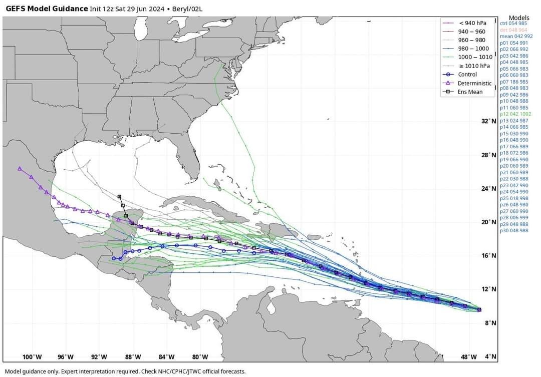 EURO
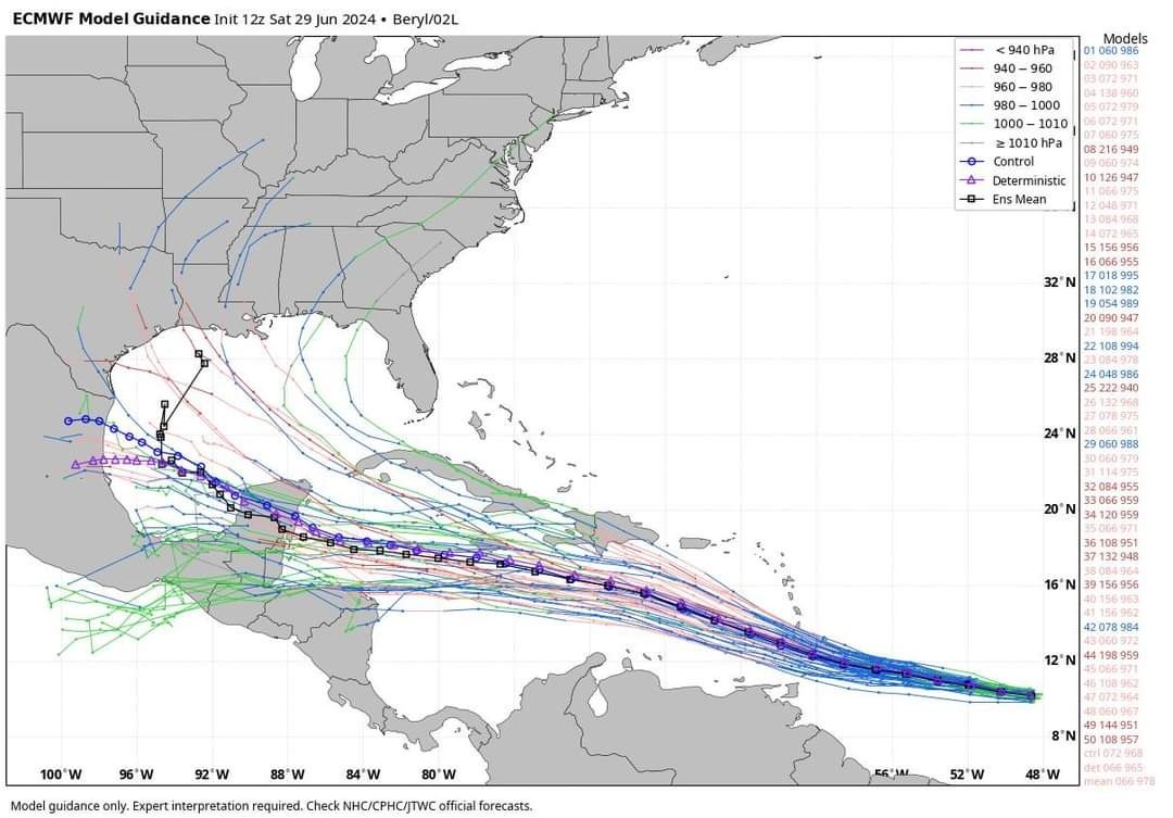
🌀
|
|
HURRICANE BERYL has formed well southeast of Barbados! The NHC forecast shows intensification into a major hurricane with a category 3 storm passing over the southern Lesser Antilles Sunday night into Monday! Here is the latest HWRF, showing a symmetric storm with 958 mb central pressure passing over St Vincent! The latest hurricane models have shifted a bit south closer to Grenada. Hurricane warnings issued for Barbados! 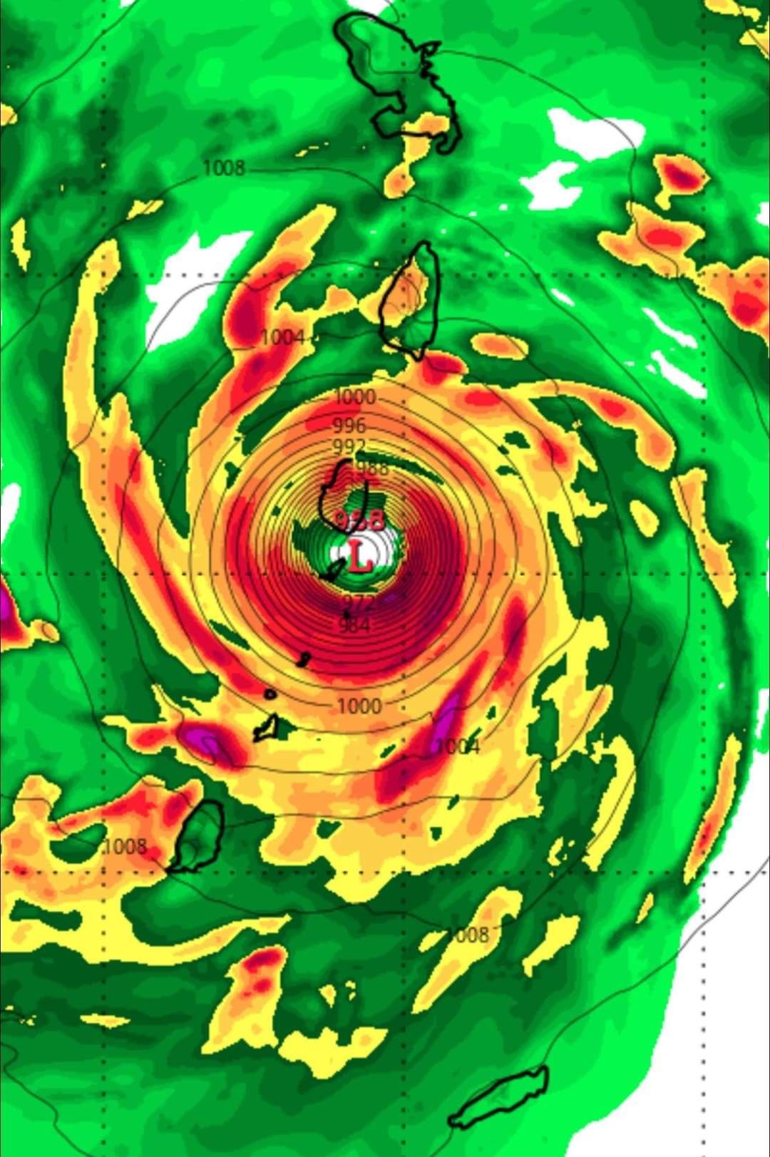
|
|
StormChaser : I am so glad you are here condensing all the info for us. Does it look like it will miss Jamaica and Haiti?
teatime : Here is the latest. Jamaica is dead center in the cone, unfortunately but it might weaken a little bit before it gets there. 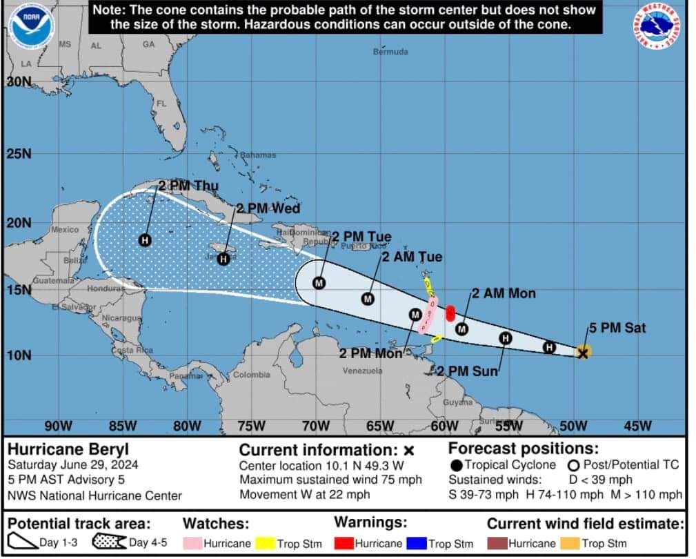
This discussion has been locked.
« Back to ChatViews: 1,165
# Replies: 10