


This week's HOT forecast
This week's HOT forecast

This discussion has been locked.

Joined:
X days ago
# Posts:
X,XXX
Contributor Points:
X


This week's HOT forecast 🔥 Welcome to summer, Houston! 🔥 Hot & humid with typical, scattered afternoon chances for sea breeze thunderstorms around ~20%.
🔥 If we're lucky enough to get one of those thunderstorms, it would cool us down quite a bit, but that's our only chance for any type of reprieve from the heat.
🔥 The dreaded term "Wet bulb" returns. (The Forecast part is below the wet bulb explanation below so skip over that part if you're not interested) 😉 Summer Really Sets In This Week For Houston, So Let's Talk About The Best Way To Measure Heat. Eric Berger · Monday, June 24, 2024 7:02 AM In brief:
*Houston will experience full-on summer conditions this week with hot days, mostly sunny skies, and sultry nights.
*To better characterize this heat, we will start using wet bulb globe temperatures more, and we explain them in today's post. WET BULB GLOBE TEMPERATURES: -As we get into the heart of summer-and yes, that's just what we're in for during the next 80 days or so-it's useful to talk "wet bulb globe temperatures." Now this is a confusing name, and it's not a simple calculation. -To derive a wet bulb globe temperature, one needs to take three different measurements: air temperature (with a thermometer), mean radiant temperature (with a black globe thermometer), and natural wet-bulb temperature (a water-soaked thermometer). Like I said, it's complicated. -However, interpreting a wet bulb globe temperature is easy, and we're going to use it a lot this summer on Space City Weather.
-Quite simply, it is a measure of how heat affects YOU: it factors in temperature, humidity, wind speed, sun angle and cloud cover. It differs from the heat index, which is less precise.
-Using this metric is especially useful if you're going to be outdoors, and not beneath shade. Basically, "high" temperatures are very warm, and "extreme" levels are borderline intolerable unless you're in a swimming pool.
-Note that last year, during this week, we were already at "extreme" heat levels.
-This year we're not quite that hot, but it's still going to be very warm. 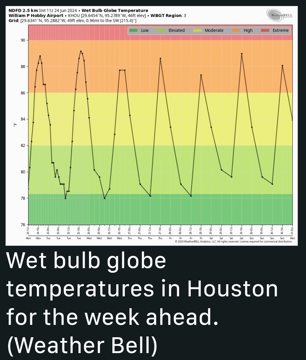 ................................... This week's forecast: MONDAY *Our weather this week will largely be dominated by high pressure, which will lead to mostly sunny days and highs generally in the mid-90s, with some inland locations reaching the upper-90s.
*There is plenty of moisture in the atmosphere, but a capping inversion is going to be difficult to break most days.
*However, I do think areas south of Interstate 10 and closer to the coast have a better chance of seeing some spotty afternoon showers along the seabreeze this week.
*I'd peg daily chances at 10 to 20 percent, with lesser odds for inland areas.
*Overnight lows will be sultry, with temperatures only briefly dropping below 80 degrees in Houston, if they do at all. TUESDAY, WEDNESDAY, THURSDAY *More of the same: Mostly sunny days, highs in the mid- to upper-90s, some isolated seabreeze showers, and warm nights.
*Winds will generally be from the southeast at 10 mph, with gusts up to 15 mph. 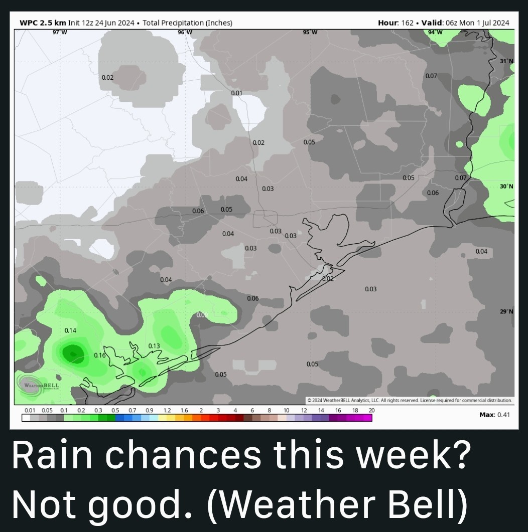 FRIDAY, SATURDAY, AND SUNDAY *The forecast remains more or less the same for the weekend: mostly sunny and hot.
*I do think rain chances may bump up slightly into the 20 to 30 percent range, but I want to see how the forecast evolves for high pressure. Will it give a bit, or will it be relentless? We shall see. TROPICS After the formation of Tropical Storm Alberto last week in the southern Gulf of Mexico, and a couple other disturbances, it looks like the tropics will go into quiescent mode for awhile now. This is perfectly normal for June, which is but an appetizer for the tropical main course, which comes in August and September for Texas. 🌀
🔥 If we're lucky enough to get one of those thunderstorms, it would cool us down quite a bit, but that's our only chance for any type of reprieve from the heat.
🔥 The dreaded term "Wet bulb" returns.
*Houston will experience full-on summer conditions this week with hot days, mostly sunny skies, and sultry nights.
*To better characterize this heat, we will start using wet bulb globe temperatures more, and we explain them in today's post.
-Quite simply, it is a measure of how heat affects YOU: it factors in temperature, humidity, wind speed, sun angle and cloud cover. It differs from the heat index, which is less precise.
-Using this metric is especially useful if you're going to be outdoors, and not beneath shade. Basically, "high" temperatures are very warm, and "extreme" levels are borderline intolerable unless you're in a swimming pool.
-Note that last year, during this week, we were already at "extreme" heat levels.
-This year we're not quite that hot, but it's still going to be very warm.
*There is plenty of moisture in the atmosphere, but a capping inversion is going to be difficult to break most days.
*However, I do think areas south of Interstate 10 and closer to the coast have a better chance of seeing some spotty afternoon showers along the seabreeze this week.
*I'd peg daily chances at 10 to 20 percent, with lesser odds for inland areas.
*Overnight lows will be sultry, with temperatures only briefly dropping below 80 degrees in Houston, if they do at all.
*Winds will generally be from the southeast at 10 mph, with gusts up to 15 mph.
*I do think rain chances may bump up slightly into the 20 to 30 percent range, but I want to see how the forecast evolves for high pressure.
Discussion Summary:
Houston Summer Forecast: Hot & Humid with Wet Bulb Globe Temperatures - How to Beat the Heat! ?????????
Houston Summer Forecast: Hot & Humid with Wet Bulb Globe Temperatures - How to Beat the Heat! ?????????
Discussion Insights:
Ask a question about this discussion and an AI bot will try to give an answer.
Ask a question about this discussion and an AI bot will try to give an answer.
Replies:
No replies yet. Be the first to respond below!
This discussion has been locked.
« Back to ChatViews: 585
# Replies: 0