


-- Removed by Author --
-- Removed by Author --

This discussion has been locked.

Joined:
X days ago
# Posts:
X,XXX
Contributor Points:
X


Discussion Summary:
Houston Weather Forecast: Promising News for Rainfall, Flooding Concerns Shift Southward
Houston Weather Forecast: Promising News for Rainfall, Flooding Concerns Shift Southward
Discussion Insights:
Ask a question about this discussion and an AI bot will try to give an answer.
Ask a question about this discussion and an AI bot will try to give an answer.
Replies:

I need the rain, my grass is looking a little dry

|
6/17/24 2pm update: These are MUCH better numbers so the trend continues to show that the area SW of here will have the major issues instead of us. (For once lol) 4-6" over 3-4 days is VERY manageable so the forecast continues to improve. 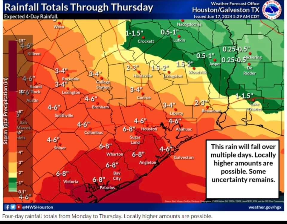 Large tropical system organizing over the Gulf of Mexico. Showers starting to spread inland as moisture increases. Conditions will deteriorate along the coast tonight into Tuesday with gusty winds (up to 45mph) and elevated tides/coastal flooding. Forecasted water levels will exceed threshold that will result in minor coastal flooding in low lying areas near the coast. Highest tides looks to be Wednesday morning between 2-8am. Extremely hazardous marine conditions will be developing and small craft need to move to and remain in port. Heavy rains remain likely especially south of I-10 Tues/Wed. Some flooding will be possible where the higher rain totals occur.

6/17/24 2pm update: These are MUCH better numbers so the trend continues to show that the area SW of here will have the major issues instead of us. (For once lol) 4-6" over 3-4 days is VERY manageable so the forecast continues to improve. Large tropical system organizing over the Gulf of Mexico. Showers starting to spread inland as moisture increases. Conditions will deteriorate along the coast tonight into Tuesday with gusty winds (up to 45mph) and elevated tides/coastal flooding. Forecasted water levels will exceed threshold that will result in minor coastal flooding in low lying areas near the coast. Highest tides looks to be Wednesday morning between 2-8am. Extremely hazardous marine conditions will be developing and small craft need to move to and remain in port. Heavy rains remain likely especially south of I-10 Tues/Wed. Some flooding will be possible where the higher rain totals occur.
 larpa tipped
 StormChaser 200 credits for a post in this forum discussion.
|
|
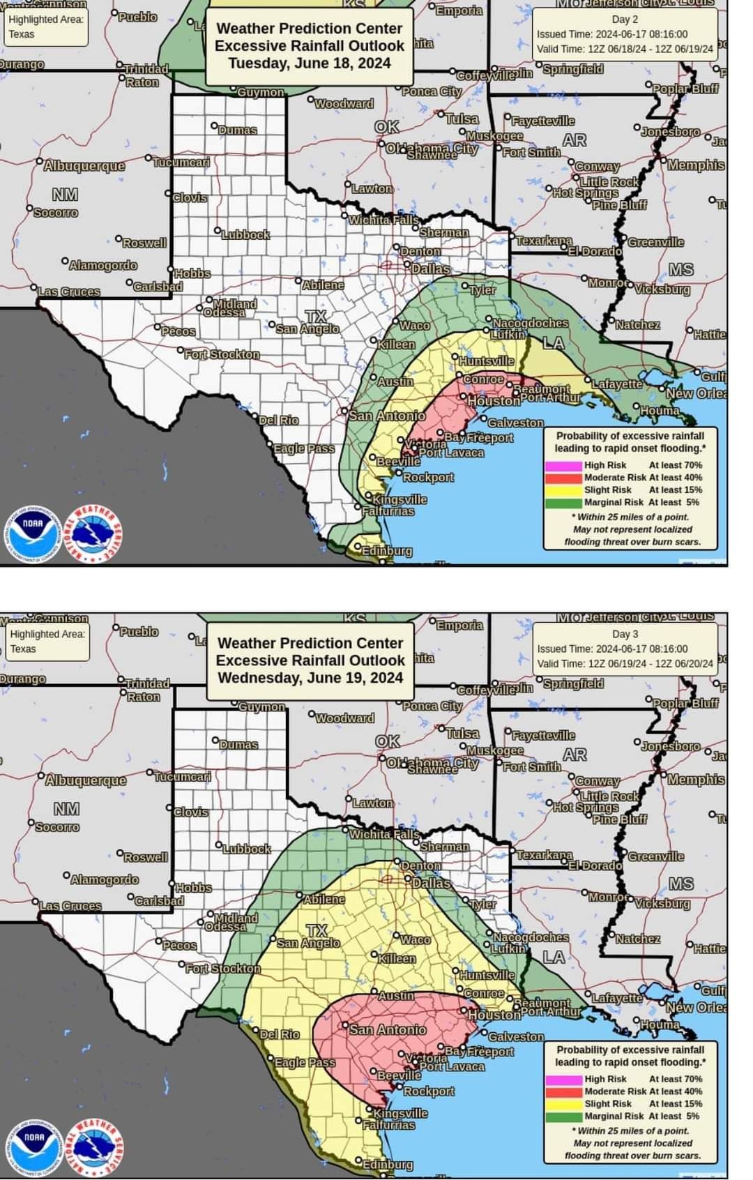
The Eyewall update. Not much has changed - flooding should stay to our SW. We may be facing a repeat forecast next week with another possible low forming in the Gulf. (Info at the bottom of this post on that.) Tis the season - Stay prepared. ..... A developing flash flood threat will occur in Texas this week, with heavy rain between Houston and Brownsville. Heaviest rains seem likely between Matagorda Bay and Corpus Christi. Invest 91L in the Bay of Campeche continues to show signs that it will develop into a lower-end system before coming ashore in northeast Mexico midweek. An Atlantic disturbance may approach the Southeast coast later this week, with low odds of lower-end development. An additional system or large area of rainfall may impact Texas and Mexico again next week. Texas axis and Invest 91L The focus for this week will be very much on Texas and Mexico as impacts from a combination of a long axis of atmospheric moisture and a possible Bay of Campeche tropical system work to deliver heavy rainfall to parts of the region. 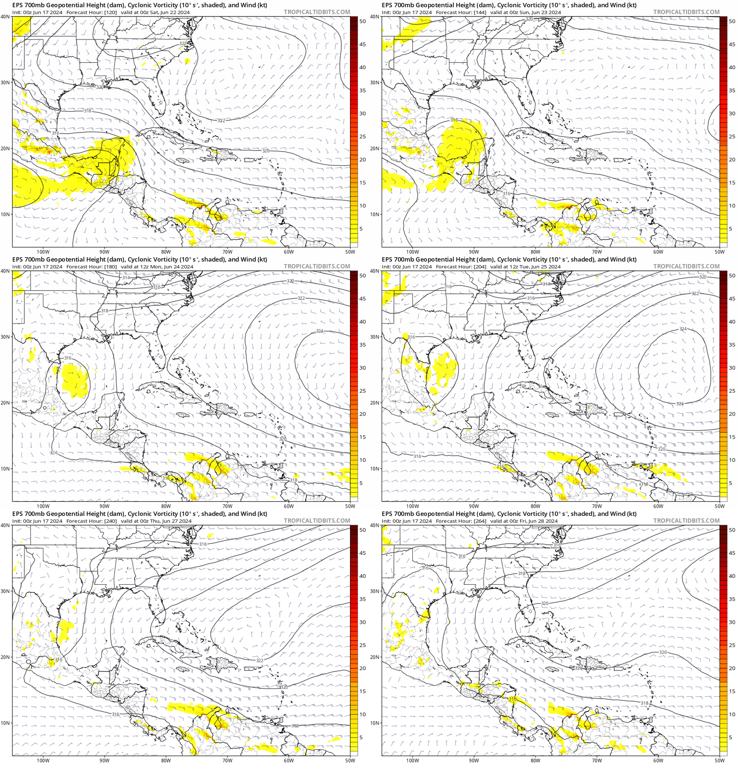 The rainfall forecast for this system will be tricky. Much like was witnessed in Florida last week, plentiful amounts of moisture in the atmosphere will lead to efficient (read: heavy) rainfall production. Put simply? The potential for some very high rain rates will be in play for the entire Texas coast this week. While the amounts above are a good average for the period, there will almost certainly be higher amounts in spots.
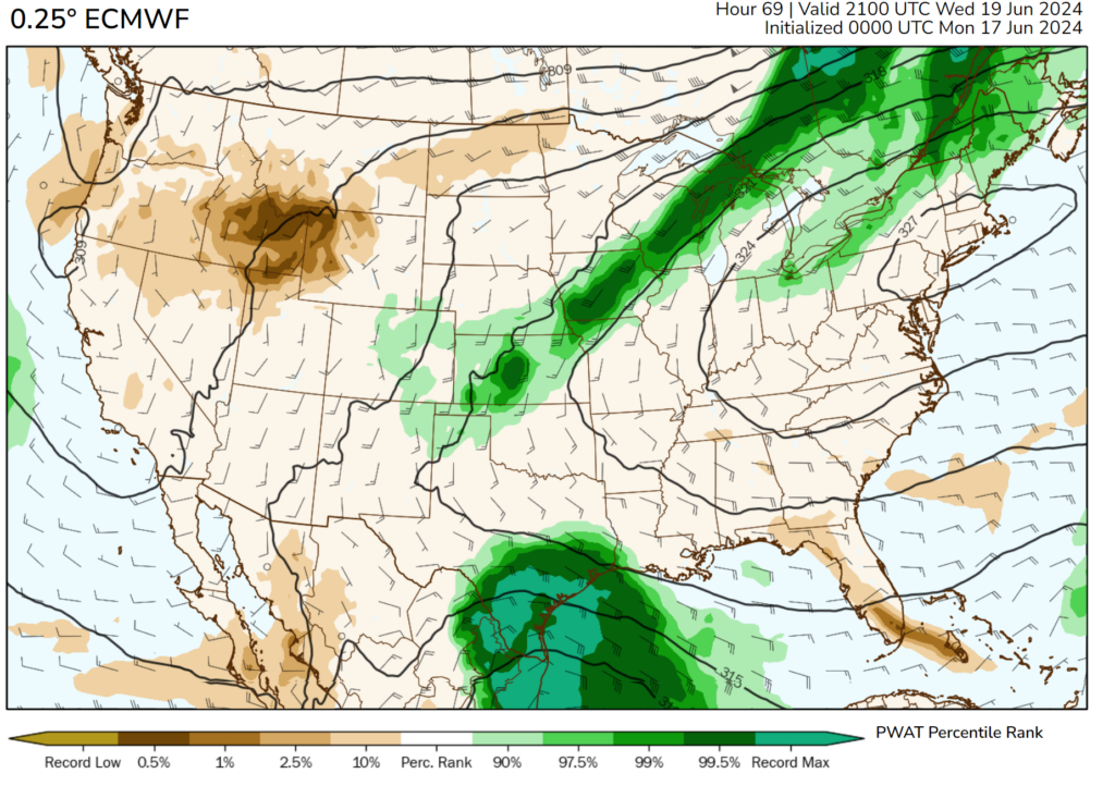 The biggest question we are faced with as forecasters is where those higher totals will occur. All weekend, we've seen some changes here and there in terms of where the "bullseye" of heavy rain will occur. In general, it looks focused on the Matagorda Bay region south into Corpus Christi, with locally heavy rain but gradually decreasing totals on either side of that. Given the moisture situation, we could easily see 10 to 15 inches in the most persistent bands, possible anywhere, but again most likely between Matagorda and Corpus Christi. Flash flooding will be a good bet in those areas, so please travel cautiously in coastal Texas this week. In addition, coastal Mexico and the mountains south of the Rio Grande will likely see elevated totals, perhaps as high as 10 inches or so. Flash flooding is a good bet in parts of Tamaulipas and Neuvo Leon. Conditions should gradually improve Thursday and Friday. Quick note: We are getting a lot of questions about vacation plans, flights, etc. We can't get to all of those, so just use your best judgment and heed the advice of local officials around your travel. Prepare for at least some delays the next couple days. In terms of tropical development, Invest 91L is what's spinning in the Bay of Campeche and has a 70 percent chance of developing into a tropical system. Hurricane hunters will be out to investigate the system later today.
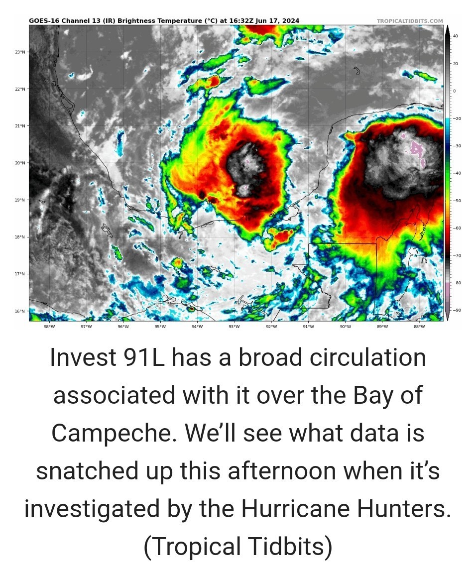 It seems that 91L has a broad circulation overall, mostly in the mid-levels of the atmosphere. To get declared as a tropical system, we'll need a low-level circulation and low pressure at the surface. It's got a little time to do this before it nudges inland over northeast Mexico midweek. Regardless of development, the broad southeast flow to the north side of it will help amplify the rain chances in South Texas and northern Mexico. Texas & Mexico rinse and repeat? We continue to also keep tabs on the potential for a follow-up round of rain and low-end tropical development next week off the Gulf Coast. Models continue to indicate continued Central American gyre activity near the Yucatan and Bay of Campeche. The pattern will finally break down later next week, with high pressure likely building into the Gulf of Mexico. But before that happens, we could see another disturbance associated with the CAG begin to track into Mexico or South Texas. This shows up nicely when you look at the "spin" in the mid-levels of the atmosphere as forecast by the European ensemble model between this weekend and next Thursday below. It's far too soon to figure out exact details here. But what we see: A CAG that begins to move and break down, the potential of a tropical system forming within that mess, and a strong signal for above normal rainfall, if not much above normal rainfall again next week in Mexico and South Texas. We'll continue to watch this closely, especially after one round of heavy rain this week.
6/17/24 2pm update: These are MUCH better numbers so the trend continues to show that the area SW of here will have the major issues instead of us. (For once lol) 4-6" over 3-4 days is VERY manageable so the forecast continues to improve. Large tropical system organizing over the Gulf of Mexico. Showers starting to spread inland as moisture increases. Conditions will deteriorate along the coast tonight into Tuesday with gusty winds (up to 45mph) and elevated tides/coastal flooding. Forecasted water levels will exceed threshold that will result in minor coastal flooding in low lying areas near the coast. Highest tides looks to be Wednesday morning between 2-8am. Extremely hazardous marine conditions will be developing and small craft need to move to and remain in port. Heavy rains remain likely especially south of I-10 Tues/Wed. Some flooding will be possible where the higher rain totals occur.
StormChaser : That's good news for us
|
|
With A 'Potential' Tropical Cyclone In The Gulf, Here's What To Expect Over The Next Two Days In Terms Of Heavy Rainfall Eric Berger · Monday, June 17, 2024 4:04 PM In brief: *We're continuing to track the potential for heavy rainfall in the greater Houston area due to a tropical system in the southern Gulf of Mexico. *Whether or not it becomes Tropical Storm Alberto, the effects will be the same for Houston. *We now think the period of Tuesday afternoon through the middle of Wednesday will have the highest chance for heavy rainfall. *On Monday afternoon the National Hurricane Center said it would begin issuing forecasts for a "potential tropical cyclone" in the southern Gulf of Mexico. *This is the tropical system that we've been talking about for several days now. This action indicates that hurricane center forecasters believe the system is likely to become a tropical depression or storm (it would be named Alberto) in the next day, but it has yet to do so. 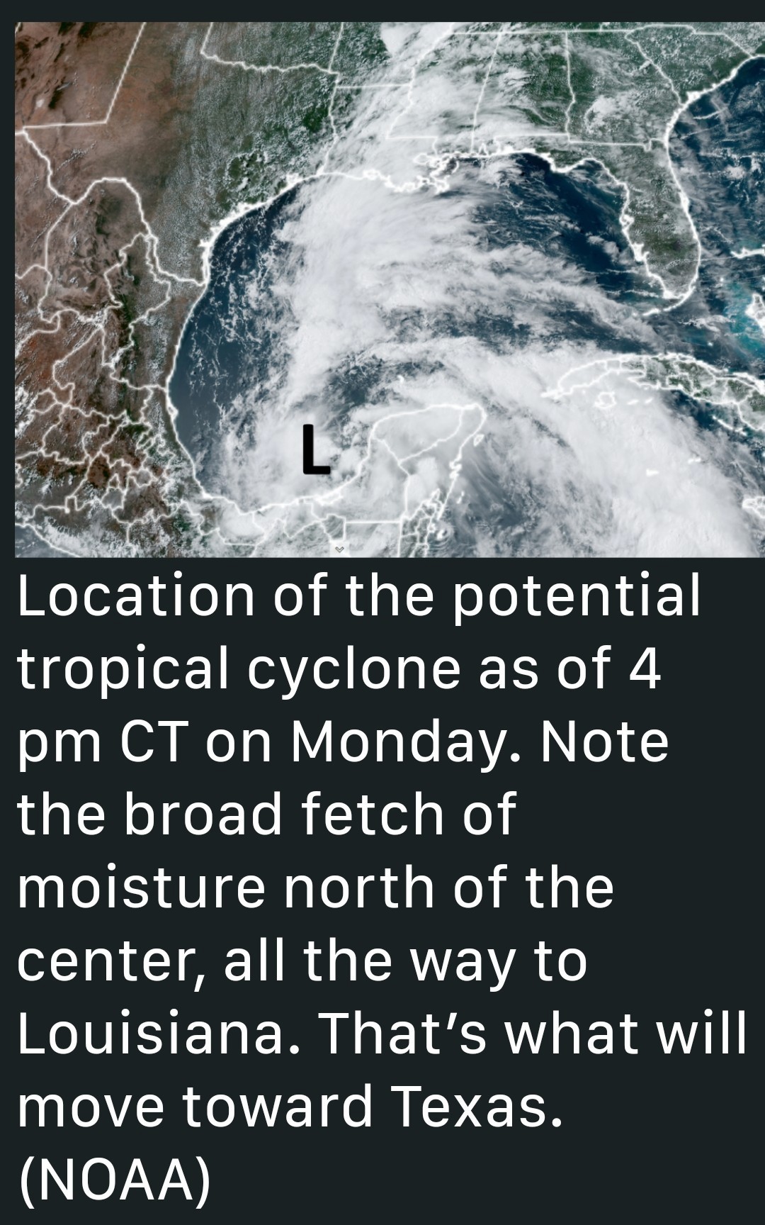 *In truth, this changes virtually nothing about the forecast for elevated easterly winds, higher seas, and heavy rainfall that Houston will experience over the next couple of days. *The purpose of this post is to attempt to set some expectations in terms of timing of the worst of the rainfall. Tropical weather is inherently unpredictable, but now that we're closing in on Tuesday and Wednesday, our confidence is a little bit higher. Emphasis on a little. MONDAY EVENING AND OVERNIGHT *As expected we've seen scattered showers and a few thunderstorms today, and generally I expect this pattern to continue this evening and overnight.
*These storms should pose no threats for flooding risks beyond putting a damper on outdoor activities. TUESDAY *Generally, I expect Tuesday morning will not bring anything too crazy in terms of sustained heavy rain. However, by around noon or shortly after that it appears a deeper slug of tropical moisture will move inland into the upper Texas coast. This is when we expect the development of more widespread showers, especially along and south of Interstate 10.
*The heaviest rain is likely to fall closer to the coast, because that is the source of the moisture. It is too early to say whether heavy rainfall on Tuesday afternoon and evening will impact commute home, but it's a distinct possibility. TUESDAY NIGHT AND WEDNESDAY *Our modeling continues to suggest that the heaviest rainfall will arrive later on Tuesday, and persist through Tuesday night through much of the day on Wednesday.
*By Wednesday evening or night, it does appear that the the worst of the rains will be exiting to our west. âž¡ï¸ I'm hesitant to speak about accumulations with too much certainty. âž¡ï¸ There continues to be a lot of noise in the models about what to expect. âž¡ï¸ There are some scenarios in which the bulk of the heavy rainfall goes south of Houston (and Galveston) on Tuesday and Wednesday - In this case the region (even coastal regions) might pick up only a handful of inches of rainfall-totally manageable. 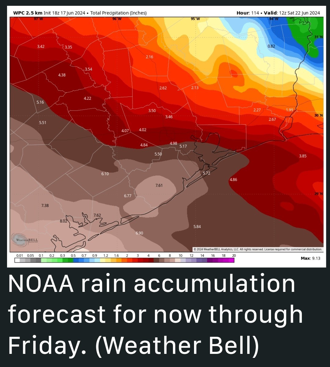 âž¡ï¸ However, I would rate as slightly more likely the possibility that the southern half of the Houston region picks up 4 to 8 inches of rainfall through Wednesday, with higher isolated amounts - This, obviously, would create some flooding issues and is the reason why we've instituted (and maintained) a Stage 2 flood alert for the entire region through Wednesday. *The thing with tropical rain is that it comes in bunches. And with this system, we have the very real possibility that at least some portions of our area will see sustained tropical rainfall during the next 48 hours. So please be prepared for that possibility. Our next update will be posted early on Tuesday morning.
*These storms should pose no threats for flooding risks beyond putting a damper on outdoor activities.
*The heaviest rain is likely to fall closer to the coast, because that is the source of the moisture. It is too early to say whether heavy rainfall on Tuesday afternoon and evening will impact commute home, but it's a distinct possibility.
*By Wednesday evening or night, it does appear that the the worst of the rains will be exiting to our west.
|
|
With A 'Potential' Tropical Cyclone In The Gulf, Here's What To Expect Over The Next Two Days In Terms Of Heavy Rainfall Eric Berger · Monday, June 17, 2024 4:04 PM In brief: *We're continuing to track the potential for heavy rainfall in the greater Houston area due to a tropical system in the southern Gulf of Mexico. *Whether or not it becomes Tropical Storm Alberto, the effects will be the same for Houston. *We now think the period of Tuesday afternoon through the middle of Wednesday will have the highest chance for heavy rainfall. *On Monday afternoon the National Hurricane Center said it would begin issuing forecasts for a "potential tropical cyclone" in the southern Gulf of Mexico. *This is the tropical system that we've been talking about for several days now. This action indicates that hurricane center forecasters believe the system is likely to become a tropical depression or storm (it would be named Alberto) in the next day, but it has yet to do so. *In truth, this changes virtually nothing about the forecast for elevated easterly winds, higher seas, and heavy rainfall that Houston will experience over the next couple of days. *The purpose of this post is to attempt to set some expectations in terms of timing of the worst of the rainfall. Tropical weather is inherently unpredictable, but now that we're closing in on Tuesday and Wednesday, our confidence is a little bit higher. Emphasis on a little. MONDAY EVENING AND OVERNIGHT *As expected we've seen scattered showers and a few thunderstorms today, and generally I expect this pattern to continue this evening and overnight. *These storms should pose no threats for flooding risks beyond putting a damper on outdoor activities. TUESDAY *Generally, I expect Tuesday morning will not bring anything too crazy in terms of sustained heavy rain. However, by around noon or shortly after that it appears a deeper slug of tropical moisture will move inland into the upper Texas coast. This is when we expect the development of more widespread showers, especially along and south of Interstate 10. *The heaviest rain is likely to fall closer to the coast, because that is the source of the moisture. It is too early to say whether heavy rainfall on Tuesday afternoon and evening will impact commute home, but it's a distinct possibility. TUESDAY NIGHT AND WEDNESDAY *Our modeling continues to suggest that the heaviest rainfall will arrive later on Tuesday, and persist through Tuesday night through much of the day on Wednesday. *By Wednesday evening or night, it does appear that the the worst of the rains will be exiting to our west. âž¡ï¸ I'm hesitant to speak about accumulations with too much certainty. âž¡ï¸ There continues to be a lot of noise in the models about what to expect. âž¡ï¸ There are some scenarios in which the bulk of the heavy rainfall goes south of Houston (and Galveston) on Tuesday and Wednesday - In this case the region (even coastal regions) might pick up only a handful of inches of rainfall-totally manageable. âž¡ï¸ However, I would rate as slightly more likely the possibility that the southern half of the Houston region picks up 4 to 8 inches of rainfall through Wednesday, with higher isolated amounts - This, obviously, would create some flooding issues and is the reason why we've instituted (and maintained) a Stage 2 flood alert for the entire region through Wednesday. *The thing with tropical rain is that it comes in bunches. And with this system, we have the very real possibility that at least some portions of our area will see sustained tropical rainfall during the next 48 hours. So please be prepared for that possibility. Our next update will be posted early on Tuesday morning.
StormChaser : Thank you. How good are you with when the power goes out? LOL!
|
|
StormChaser : That's good news for us
 sweetie : Yes. It will be manageable with this forecast. The totals are still unknown but 4-8" will be common. It's a lot but it's manageable in 3 days.
|
|
StormChaser : Thank you. How good are you with when the power goes out? LOL!
 cbear : Haha I try to remember it's ERCOTS fault and not theirs lol. 🙃
This discussion has been locked.
« Back to ChatViews: 2,645
# Replies: 25