


Removed By Request.
Removed By Request.

This discussion has been locked.

Joined:
X days ago
# Posts:
X,XXX
Contributor Points:
X


Discussion Summary:
Tropical Depression Three Forms in Atlantic with Potential to Strengthen into Hurricane and Impact Lesser Antilles
Tropical Depression Three Forms in Atlantic with Potential to Strengthen into Hurricane and Impact Lesser Antilles
Discussion Insights:
Ask a question about this discussion and an AI bot will try to give an answer.
Ask a question about this discussion and an AI bot will try to give an answer.
Replies:


|

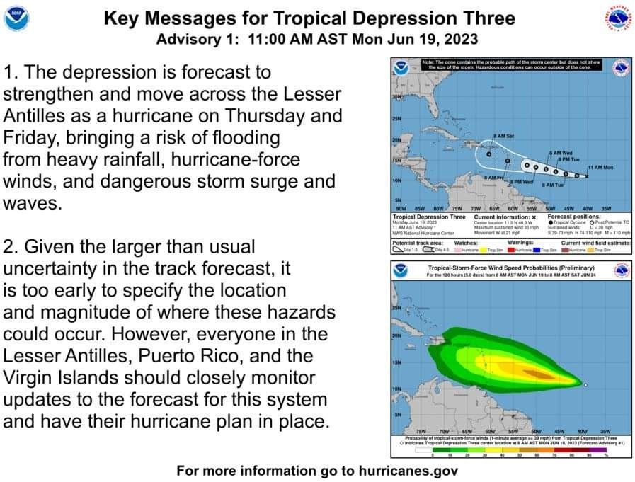
Tropics update ...TROPICAL DEPRESSION THREE FORMS OVER THE CENTRAL ATLANTIC... ...INTERESTS IN THE LESSER ANTILLES SHOULD MONITOR THIS SYSTEM... Here are the Key Messages for Tropical Depression Three Advisory 1: 11:00 a.m. AST Monday June 19, 2023 1. The depression is forecast to strengthen and move across the Lesser Antilles as a hurricane on Thursday and Friday, bringing a risk of flooding from heavy rainfall, hurricane-force winds, and dangerous storm surge and waves. 2. Given the larger than usual uncertainty in the track forecast, it is too early to specify the location and magnitude of where these hazards could occur. However, everyone in the Lesser Antilles, Puerto Rico, and the Virgin Islands should closely monitor updates to the forecast for this system and have their hurricane plan in place. For more information, visit: hurricanes.gov Marine forecast: hurricanes.gov/marine
 StormChaser : I was wondering when you would be on to keep us informed. Thanks.
🌀BREAKING: Atlantic tropical depression strengthens, set to become Tropical Storm Bret with forecasted hurricane status by the end of the week! Environmental conditions appear conducive for strengthening over the next few days, with a much warmer than normal ocean in the depression's path, along with plentiful mid-level moisture and light shear. This should promote strengthening through midweek. Important to note vertical wind shear is forecasted to increase by most of the model guidance around day 3 in response to an upper-level trough. Thus the NHC forecast shows the intensity leveling off at the end of the forecast, consistent with the middle of the guidance envelope. This intensity forecast is also more uncertain than normal, due to the differences in the model suite, along with the aclimatological nature of this system. KEY MESSAGES: 1. The depression is forecast to strengthen and move across the Lesser Antilles as a hurricane on Thursday and Friday, bringing a risk of flooding from heavy rainfall, hurricane-force winds, and dangerous storm surge and waves. 2. Given the larger than usual uncertainty in the track forecast, it is too early to specify the location and magnitude of where these hazards could occur. However, everyone in the Lesser Antilles, Puerto Rico, and the Virgin Islands should closely monitor updates to the forecast for this system and have their hurricane plan in place. Stay tuned!
StormChaser : Key question:
Tropics update 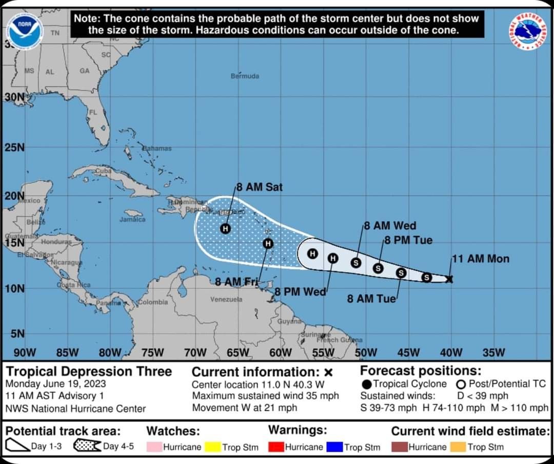
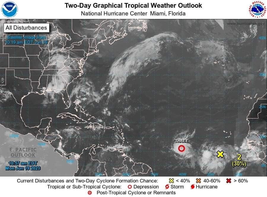 ...TROPICAL DEPRESSION THREE FORMS OVER THE CENTRAL ATLANTIC...
...INTERESTS IN THE LESSER ANTILLES SHOULD MONITOR THIS SYSTEM... Here are the Key Messages for Tropical Depression Three
Advisory 1: 11:00 a.m. AST Monday June 19, 2023 1. The depression is forecast to strengthen and move across the
Lesser Antilles as a hurricane on Thursday and Friday, bringing a
risk of flooding from heavy rainfall, hurricane-force winds, and
dangerous storm surge and waves. 2. Given the larger than usual uncertainty in the track forecast,
it is too early to specify the location and magnitude of where
these hazards could occur. However, everyone in the Lesser
Antilles, Puerto Rico, and the Virgin Islands should closely monitor
updates to the forecast for this system and have their hurricane
plan in place. For more information, visit: hurricanes.gov
Marine forecast: hurricanes.gov/marine
...INTERESTS IN THE LESSER ANTILLES SHOULD MONITOR THIS SYSTEM...
Advisory 1: 11:00 a.m. AST Monday June 19, 2023
Lesser Antilles as a hurricane on Thursday and Friday, bringing a
risk of flooding from heavy rainfall, hurricane-force winds, and
dangerous storm surge and waves.
it is too early to specify the location and magnitude of where
these hazards could occur. However, everyone in the Lesser
Antilles, Puerto Rico, and the Virgin Islands should closely monitor
updates to the forecast for this system and have their hurricane
plan in place.
Marine forecast: hurricanes.gov/marine
 Maver1ck tipped StormChaser 100 credits for a post in this forum discussion.
|
|
|
|
 buffaloglenn : Happy KDC birthday my friend. Enjoy the calorie free cake!!
  MMMM cake does sound good!
Tropics update ...TROPICAL DEPRESSION THREE FORMS OVER THE CENTRAL ATLANTIC... ...INTERESTS IN THE LESSER ANTILLES SHOULD MONITOR THIS SYSTEM... Here are the Key Messages for Tropical Depression Three Advisory 1: 11:00 a.m. AST Monday June 19, 2023 1. The depression is forecast to strengthen and move across the Lesser Antilles as a hurricane on Thursday and Friday, bringing a risk of flooding from heavy rainfall, hurricane-force winds, and dangerous storm surge and waves. 2. Given the larger than usual uncertainty in the track forecast, it is too early to specify the location and magnitude of where these hazards could occur. However, everyone in the Lesser Antilles, Puerto Rico, and the Virgin Islands should closely monitor updates to the forecast for this system and have their hurricane plan in place. For more information, visit: hurricanes.gov Marine forecast: hurricanes.gov/marine
StormChaser : Ugh I just heard about this and looked for a post form you and sure enough you posted it here. Thank you This discussion has been locked.
« Back to ChatViews: 480
# Replies: 14