


Changes in Beryl - SAT 4AM (PG 7)
Changes in Beryl - SAT 4AM (PG 7)

This discussion has been locked.

Joined:
X days ago
# Posts:
X,XXX
Contributor Points:
X
Discussion Summary:
Hurricane Beryl Shifts Northward and Expected to Make Landfall in Texas, Impacting Houston Area
Hurricane Beryl Shifts Northward and Expected to Make Landfall in Texas, Impacting Houston Area
Discussion Insights:
Ask a question about this discussion and an AI bot will try to give an answer.
Ask a question about this discussion and an AI bot will try to give an answer.
Replies:


|

 Donnawisdom
|
|
Hell I'll even post Herzogs post lol. Friday Beryl Update: Do not turn your back on Beryl. 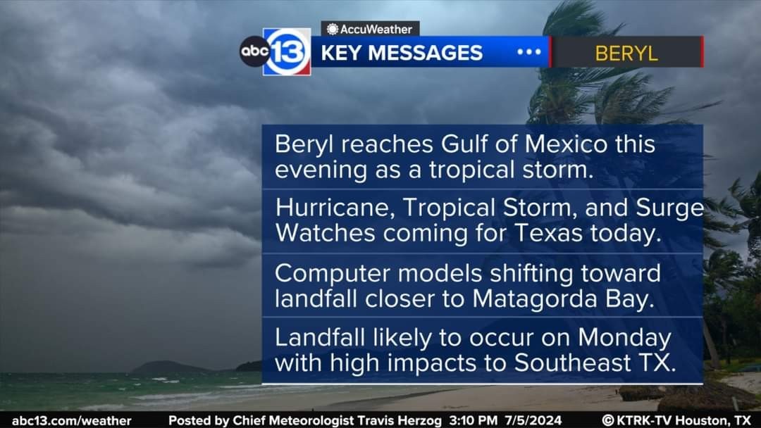 Yes, it's now a tropical storm, but it is once again veering off course. *Here in Southeast Texas we need to prepare for a big shift in expectations.
*The storm has continued to track on the right side of the cone, and the newest computer model data is putting the storm's landfall closer to Matagorda Bay. *This will greatly increase the expected impacts here in Southeast Texas.
*Additionally, it will emerge over water in a few hours with its main core still intact, allowing for intensification to resume.
Thank you  stormchaser for your amazing coverage and updates! I find this much better than watching the weather channel or reading the news. Your reporting is very helpful, so thank you!
|
|


Hell I'll even post Herzogs post lol. Friday Beryl Update: Do not turn your back on Beryl. Yes, it's now a tropical storm, but it is once again veering off course. *Here in Southeast Texas we need to prepare for a big shift in expectations. *The storm has continued to track on the right side of the cone, and the newest computer model data is putting the storm's landfall closer to Matagorda Bay. *This will greatly increase the expected impacts here in Southeast Texas. *Additionally, it will emerge over water in a few hours with its main core still intact, allowing for intensification to resume.
StormChaser : I really trust your take on this and thank YOU!!!!
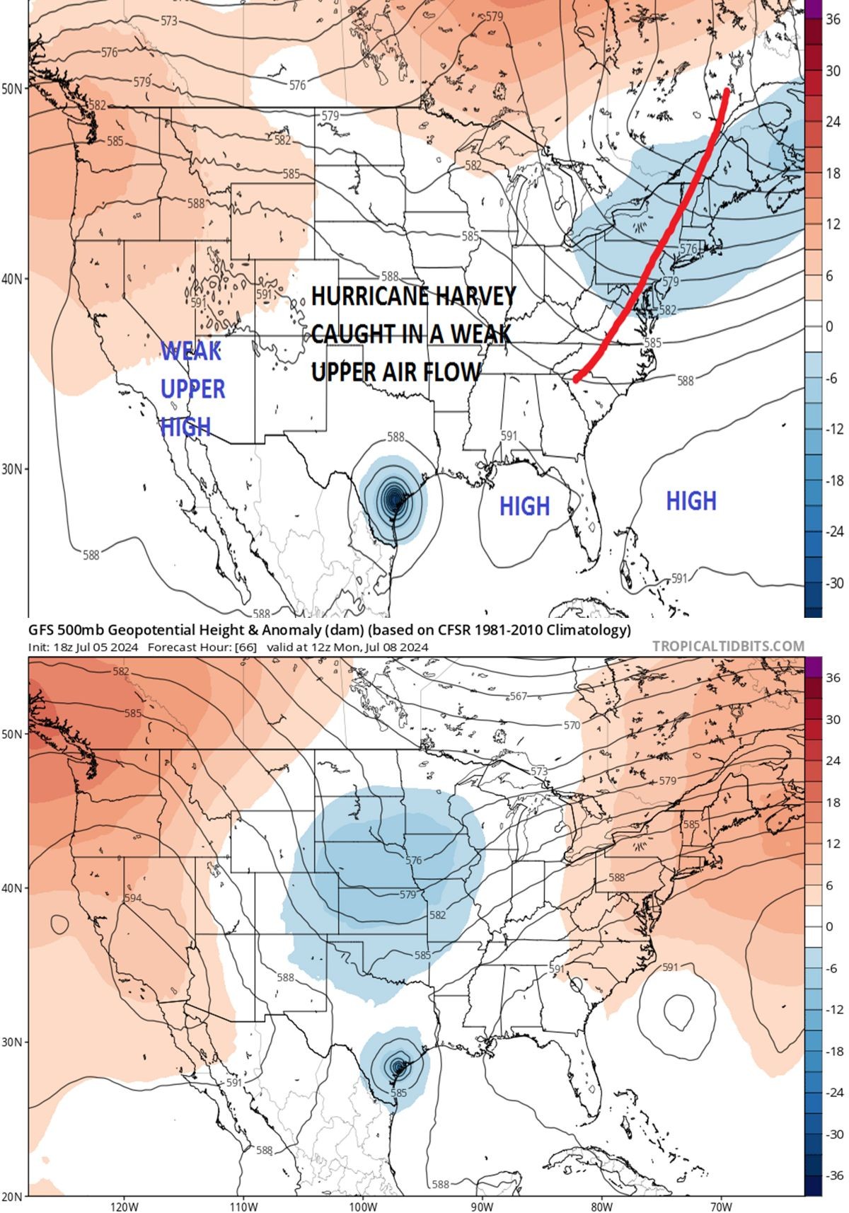
Oh Beryl starting to feel that open window from that Low Pressure pushing down. He will want to make a run for the north.
|
|
 teatime :
It's definitely nice to know we have someone in here that will keep us informed. Safe travels home.
 StormChaser :
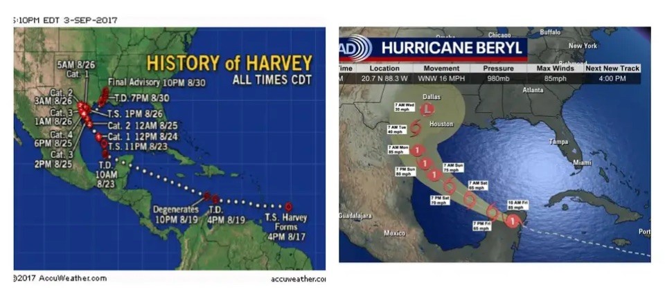
This is giving me flashbacks to Harvey. Harvey did his 'strike and bounce' when he came ashore around Corpus. And we know how that worked out for us.
StormChaser : That thing is starting to looking like a big U-turn. Please let me know pronto if new reports come in and you think Beryl might head for the New Orleans area.
Hell I'll even post Herzogs post lol. Friday Beryl Update: Do not turn your back on Beryl. Yes, it's now a tropical storm, but it is once again veering off course. *Here in Southeast Texas we need to prepare for a big shift in expectations. *The storm has continued to track on the right side of the cone, and the newest computer model data is putting the storm's landfall closer to Matagorda Bay. *This will greatly increase the expected impacts here in Southeast Texas. *Additionally, it will emerge over water in a few hours with its main core still intact, allowing for intensification to resume.
StormChaser : let's have  travisherzog chime in. Isn't there a few a meteorologist from channel 2 or 11 that is on here too? I watch channel 13 every since I can remember. I think the other meteorologists names was Frank, or something....ðŸ«
|
|
 peppermintstick
This discussion has been locked.
« Back to ChatViews: 8,158
# Replies: 102