


Next week's forecast
Next week's forecast

This discussion has been locked.

Joined:
X days ago
# Posts:
X,XXX
Contributor Points:
X
Discussion Summary:
Discussion on Next Week's Rain Forecast for Houston: Potential impacts of tropical development in Bay of Campeche and uncertainty in rainfall totals explained.
Discussion on Next Week's Rain Forecast for Houston: Potential impacts of tropical development in Bay of Campeche and uncertainty in rainfall totals explained.
Discussion Insights:
Ask a question about this discussion and an AI bot will try to give an answer.
Ask a question about this discussion and an AI bot will try to give an answer.
Replies:


 StormChaser :
I'm so glad you're back! It really stinks when you're trying to help people and some bone heads need to say something! I'm proud of you, coming back to share your weather reports, we love them and you! If the bone heads come back, just put them on ignore (we still have that option I think). You do what you do, those of us who want to read what you've written will, and the rest....you know what they can do!!!

|
There's definitely something missing when you're not here! I'm so happy you're back and can guide us all through our weird and mostly unpredictable Texas weather. Keep up the great work!!!
Next week's forecast For those asking, here is the forecast. I know a lot of you have messaged/tagged me but I had to back away for a while. I'm not looking for a pat on the back for posting about weather (why would I when #1 anyone can do it and #2 I love it so much) but I'm also not going to sit and be **** on either. The majority of you keep scrolling if weather isn't your thing (which I GREATLY appreciate) but on that day people were coming out of the woodwork on here (and then later it continued on social media) I can take being told I'm wrong but damn. It's just not worth what that type of BS does to my mental health so I logged off. 🤷â€â™€ï¸ Yes, I'm ok & I'm sober. â¤ï¸ All I ask is that you don't care to read about the weather, or you feel the need to criticize my weather posts, please just move on. Please. ......................................... Anywho - back to the ⛈ï¸âš¡ðŸŒ€â˜” This is a pretty sloppy forecast for a lot of reasons (now we have AI in play with weather forecasts) but the bottom like is: *The tropical development in the Bay of Campeche will NOT directly impact Houston, but indirect impacts will.
*Right now, the uncertainty comes in the form of rainfall totals. Will we see 2" of rain or will we see 6" of rain? *As of today (Friday) that part is still unknown but thankfully the forecast does NOT have a tropical system on our another website week. ........ From Space City Weather: Details Continue To Evolve On Next Week's Rain In Houston With A Focus Now On Midweek Matt Lanza · Friday, June 14, 2024 7:29 AM In brief: *After a quiet weekend, rain chances pick back up Monday and Tuesday before potentially heavier and more widespread rain on Wednesday and Thursday.
*Tropical development in the Bay of Campeche will NOT directly impact Houston, but indirect impacts with rough seas, gusty coastal winds, and some tidal flooding will be possible. Right out of the gate, we want to make sure people understand that next week's weather is being driven by two entities: -The first is the potential tropical system in the Bay of Campeche, which will NOT directly impact us. -The second will be the heavy rainfall on the north side, tangentially associated with it, that will impact us. The latter continues to give us some forecast headaches, which we'll explain below. TODAY AND SATURDAY: No issues are expected with plentiful sunshine. SUNDAY: For now, we expect much the same for Sunday, though a few extra clouds could begin to sneak in for the second half of the day, along with an isolated shower or downpour. 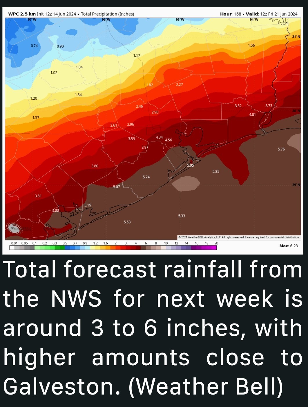 MONDAY & TUESDAY: *We expect scattered to potentially numerous showers and thunderstorms in the area on Monday and Tuesday afternoons, though it's a bit soon to pin down exactly where these will be most likely.
*Think of the first couple days of the week as slightly juicier typical summer days. There could be a handful of stronger storms or localized heavy downpours.
*This should keep temperatures down a bit as well, mostly in the 80s to near 90 degrees. âœ³ï¸ WEDNESDAY & THURSDAY: âž¡ï¸ We are beginning to see a decent model agreement that Tuesday night, Wednesday, and early Thursday will feature our highest rain chances, and with that will likely come some heavy rainfall.
âž¡ï¸ I think this is the timeframe where I would be watching closest for potential flash flooding.
âž¡ï¸ The trouble right now is that our models widely differ on where this occurs.
âž¡ï¸ Our typical physics-based models are focusing things on the entirety of the Texas coast.
âž¡ï¸ While our newer AI models favor Houston into Louisiana for the heaviest rainfall. 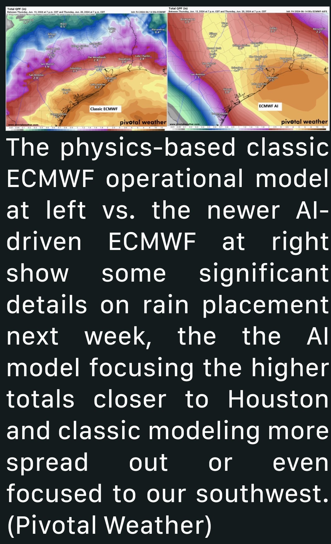 âž¡ï¸ One other possibility in this scenario is that a lot of rain falls at the immediate coast +or offshore) which ends up depriving inland areas of moisture.
âž¡ï¸ There is at least a chance that we will see a very sharp gradient of rainfall next week with high totals near Galveston and very manageable totals in Houston. Things should hopefully quiet down later Thursday and Friday, regardless. BAY OF CAMPECHE SYSTEM: We continue to see about a 50/50 shot that a tropical system develops in the Bay of Campeche next week.
*As noted above, this is related but separate from the rain we see next week.
*While development (low-end) is becoming more possible or likely, it is expected to quickly slide ashore in Mexico, so no direct impacts are expected on the Texas coast. 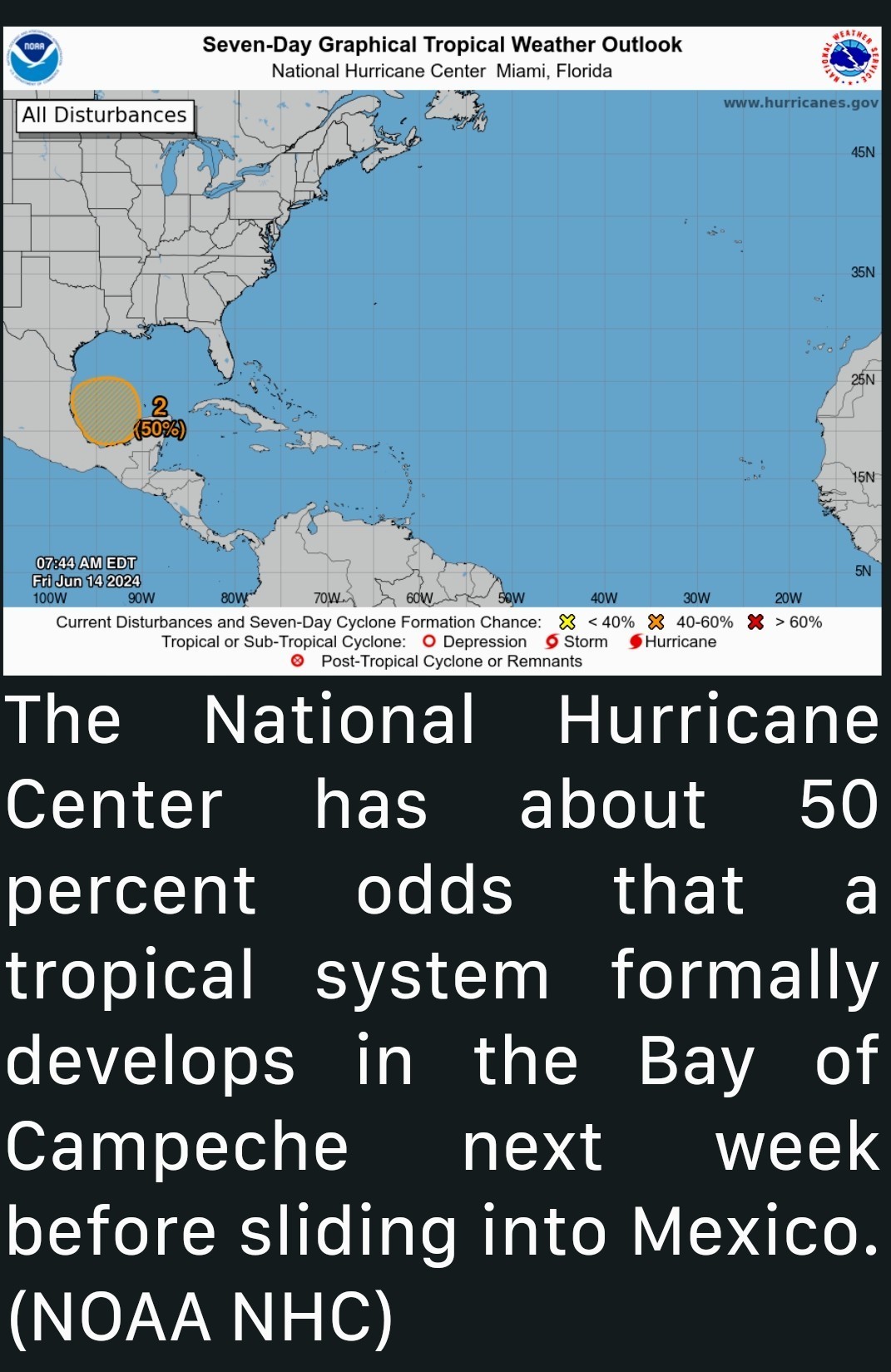 *Beyond this, there may be another sloppy system that tries to develop the week of June 24th, but we have plenty of time to watch that.... We'll have more on next week's situation over the weekend.
*Right now, the uncertainty comes in the form of rainfall totals. Will we see 2" of rain or will we see 6" of rain?
*Tropical development in the Bay of Campeche will NOT directly impact Houston, but indirect impacts with rough seas, gusty coastal winds, and some tidal flooding will be possible.
*Think of the first couple days of the week as slightly juicier typical summer days. There could be a handful of stronger storms or localized heavy downpours.
*This should keep temperatures down a bit as well, mostly in the 80s to near 90 degrees.
âž¡ï¸ I think this is the timeframe where I would be watching closest for potential flash flooding.
âž¡ï¸ The trouble right now is that our models widely differ on where this occurs.
âž¡ï¸ Our typical physics-based models are focusing things on the entirety of the Texas coast.
âž¡ï¸ While our newer AI models favor Houston into Louisiana for the heaviest rainfall.
âž¡ï¸ There is at least a chance that we will see a very sharp gradient of rainfall next week with high totals near Galveston and very manageable totals in Houston.
*As noted above, this is related but separate from the rain we see next week.
*While development (low-end) is becoming more possible or likely, it is expected to quickly slide ashore in Mexico, so no direct impacts are expected on the Texas coast.
 Txmomx5 tipped StormChaser 100 credits for a post in this forum discussion.
StormChaser: welcome back… I just want to say… you do what makes you happy… you can't control others reactions. They dont run your temple, you do! Another thing. Weather is a prediction, no one is a master. Don't let them scare you away or cause you to have to step away. Dont give them your power. Tell them to kick rocks when people come after you. You take care!
Next week's forecast For those asking, here is the forecast. I know a lot of you have messaged/tagged me but I had to back away for a while. I'm not looking for a pat on the back for posting about weather (why would I when #1 anyone can do it and #2 I love it so much) but I'm also not going to sit and be **** on either. The majority of you keep scrolling if weather isn't your thing (which I GREATLY appreciate) but on that day people were coming out of the woodwork on here (and then later it continued on social media) I can take being told I'm wrong but damn. It's just not worth what that type of BS does to my mental health so I logged off. 🤷â€â™€ï¸ Yes, I'm ok & I'm sober. â¤ï¸ All I ask is that you don't care to read about the weather, or you feel the need to criticize my weather posts, please just move on. Please. ......................................... Anywho - back to the ⛈ï¸âš¡ðŸŒ€â˜” This is a pretty sloppy forecast for a lot of reasons (now we have AI in play with weather forecasts) but the bottom like is: *The tropical development in the Bay of Campeche will NOT directly impact Houston, but indirect impacts will.
*Right now, the uncertainty comes in the form of rainfall totals. Will we see 2" of rain or will we see 6" of rain? *As of today (Friday) that part is still unknown but thankfully the forecast does NOT have a tropical system on our another website week. ........ From Space City Weather: Details Continue To Evolve On Next Week's Rain In Houston With A Focus Now On Midweek Matt Lanza · Friday, June 14, 2024 7:29 AM In brief: *After a quiet weekend, rain chances pick back up Monday and Tuesday before potentially heavier and more widespread rain on Wednesday and Thursday.
*Tropical development in the Bay of Campeche will NOT directly impact Houston, but indirect impacts with rough seas, gusty coastal winds, and some tidal flooding will be possible. Right out of the gate, we want to make sure people understand that next week's weather is being driven by two entities: -The first is the potential tropical system in the Bay of Campeche, which will NOT directly impact us. -The second will be the heavy rainfall on the north side, tangentially associated with it, that will impact us. The latter continues to give us some forecast headaches, which we'll explain below. TODAY AND SATURDAY: No issues are expected with plentiful sunshine. SUNDAY: For now, we expect much the same for Sunday, though a few extra clouds could begin to sneak in for the second half of the day, along with an isolated shower or downpour. MONDAY & TUESDAY: *We expect scattered to potentially numerous showers and thunderstorms in the area on Monday and Tuesday afternoons, though it's a bit soon to pin down exactly where these will be most likely.
*Think of the first couple days of the week as slightly juicier typical summer days. There could be a handful of stronger storms or localized heavy downpours.
*This should keep temperatures down a bit as well, mostly in the 80s to near 90 degrees. âœ³ï¸ WEDNESDAY & THURSDAY: âž¡ï¸ We are beginning to see a decent model agreement that Tuesday night, Wednesday, and early Thursday will feature our highest rain chances, and with that will likely come some heavy rainfall.
âž¡ï¸ I think this is the timeframe where I would be watching closest for potential flash flooding.
âž¡ï¸ The trouble right now is that our models widely differ on where this occurs.
âž¡ï¸ Our typical physics-based models are focusing things on the entirety of the Texas coast.
âž¡ï¸ While our newer AI models favor Houston into Louisiana for the heaviest rainfall. âž¡ï¸ One other possibility in this scenario is that a lot of rain falls at the immediate coast +or offshore) which ends up depriving inland areas of moisture.
âž¡ï¸ There is at least a chance that we will see a very sharp gradient of rainfall next week with high totals near Galveston and very manageable totals in Houston. Things should hopefully quiet down later Thursday and Friday, regardless. BAY OF CAMPECHE SYSTEM: We continue to see about a 50/50 shot that a tropical system develops in the Bay of Campeche next week.
*As noted above, this is related but separate from the rain we see next week.
*While development (low-end) is becoming more possible or likely, it is expected to quickly slide ashore in Mexico, so no direct impacts are expected on the Texas coast. *Beyond this, there may be another sloppy system that tries to develop the week of June 24th, but we have plenty of time to watch that.... We'll have more on next week's situation over the weekend.
*Right now, the uncertainty comes in the form of rainfall totals. Will we see 2" of rain or will we see 6" of rain?
*Tropical development in the Bay of Campeche will NOT directly impact Houston, but indirect impacts with rough seas, gusty coastal winds, and some tidal flooding will be possible.
*Think of the first couple days of the week as slightly juicier typical summer days. There could be a handful of stronger storms or localized heavy downpours.
*This should keep temperatures down a bit as well, mostly in the 80s to near 90 degrees.
âž¡ï¸ I think this is the timeframe where I would be watching closest for potential flash flooding.
âž¡ï¸ The trouble right now is that our models widely differ on where this occurs.
âž¡ï¸ Our typical physics-based models are focusing things on the entirety of the Texas coast.
âž¡ï¸ While our newer AI models favor Houston into Louisiana for the heaviest rainfall.
âž¡ï¸ There is at least a chance that we will see a very sharp gradient of rainfall next week with high totals near Galveston and very manageable totals in Houston.
*As noted above, this is related but separate from the rain we see next week.
*While development (low-end) is becoming more possible or likely, it is expected to quickly slide ashore in Mexico, so no direct impacts are expected on the Texas coast.
 malpalface tipped StormChaser 100 credits for a post in this forum discussion.
Next week's forecast For those asking, here is the forecast. I know a lot of you have messaged/tagged me but I had to back away for a while. I'm not looking for a pat on the back for posting about weather (why would I when #1 anyone can do it and #2 I love it so much) but I'm also not going to sit and be **** on either. The majority of you keep scrolling if weather isn't your thing (which I GREATLY appreciate) but on that day people were coming out of the woodwork on here (and then later it continued on social media) I can take being told I'm wrong but damn. It's just not worth what that type of BS does to my mental health so I logged off. 🤷â€â™€ï¸ Yes, I'm ok & I'm sober. â¤ï¸ All I ask is that you don't care to read about the weather, or you feel the need to criticize my weather posts, please just move on. Please. ......................................... Anywho - back to the ⛈ï¸âš¡ðŸŒ€â˜” This is a pretty sloppy forecast for a lot of reasons (now we have AI in play with weather forecasts) but the bottom like is: *The tropical development in the Bay of Campeche will NOT directly impact Houston, but indirect impacts will.
*Right now, the uncertainty comes in the form of rainfall totals. Will we see 2" of rain or will we see 6" of rain? *As of today (Friday) that part is still unknown but thankfully the forecast does NOT have a tropical system on our another website week. ........ From Space City Weather: Details Continue To Evolve On Next Week's Rain In Houston With A Focus Now On Midweek Matt Lanza · Friday, June 14, 2024 7:29 AM In brief: *After a quiet weekend, rain chances pick back up Monday and Tuesday before potentially heavier and more widespread rain on Wednesday and Thursday.
*Tropical development in the Bay of Campeche will NOT directly impact Houston, but indirect impacts with rough seas, gusty coastal winds, and some tidal flooding will be possible. Right out of the gate, we want to make sure people understand that next week's weather is being driven by two entities: -The first is the potential tropical system in the Bay of Campeche, which will NOT directly impact us. -The second will be the heavy rainfall on the north side, tangentially associated with it, that will impact us. The latter continues to give us some forecast headaches, which we'll explain below. TODAY AND SATURDAY: No issues are expected with plentiful sunshine. SUNDAY: For now, we expect much the same for Sunday, though a few extra clouds could begin to sneak in for the second half of the day, along with an isolated shower or downpour. MONDAY & TUESDAY: *We expect scattered to potentially numerous showers and thunderstorms in the area on Monday and Tuesday afternoons, though it's a bit soon to pin down exactly where these will be most likely.
*Think of the first couple days of the week as slightly juicier typical summer days. There could be a handful of stronger storms or localized heavy downpours.
*This should keep temperatures down a bit as well, mostly in the 80s to near 90 degrees. âœ³ï¸ WEDNESDAY & THURSDAY: âž¡ï¸ We are beginning to see a decent model agreement that Tuesday night, Wednesday, and early Thursday will feature our highest rain chances, and with that will likely come some heavy rainfall.
âž¡ï¸ I think this is the timeframe where I would be watching closest for potential flash flooding.
âž¡ï¸ The trouble right now is that our models widely differ on where this occurs.
âž¡ï¸ Our typical physics-based models are focusing things on the entirety of the Texas coast.
âž¡ï¸ While our newer AI models favor Houston into Louisiana for the heaviest rainfall. âž¡ï¸ One other possibility in this scenario is that a lot of rain falls at the immediate coast +or offshore) which ends up depriving inland areas of moisture.
âž¡ï¸ There is at least a chance that we will see a very sharp gradient of rainfall next week with high totals near Galveston and very manageable totals in Houston. Things should hopefully quiet down later Thursday and Friday, regardless. BAY OF CAMPECHE SYSTEM: We continue to see about a 50/50 shot that a tropical system develops in the Bay of Campeche next week.
*As noted above, this is related but separate from the rain we see next week.
*While development (low-end) is becoming more possible or likely, it is expected to quickly slide ashore in Mexico, so no direct impacts are expected on the Texas coast. *Beyond this, there may be another sloppy system that tries to develop the week of June 24th, but we have plenty of time to watch that.... We'll have more on next week's situation over the weekend.
*Right now, the uncertainty comes in the form of rainfall totals. Will we see 2" of rain or will we see 6" of rain?
*Tropical development in the Bay of Campeche will NOT directly impact Houston, but indirect impacts with rough seas, gusty coastal winds, and some tidal flooding will be possible.
*Think of the first couple days of the week as slightly juicier typical summer days. There could be a handful of stronger storms or localized heavy downpours.
*This should keep temperatures down a bit as well, mostly in the 80s to near 90 degrees.
âž¡ï¸ I think this is the timeframe where I would be watching closest for potential flash flooding.
âž¡ï¸ The trouble right now is that our models widely differ on where this occurs.
âž¡ï¸ Our typical physics-based models are focusing things on the entirety of the Texas coast.
âž¡ï¸ While our newer AI models favor Houston into Louisiana for the heaviest rainfall.
âž¡ï¸ There is at least a chance that we will see a very sharp gradient of rainfall next week with high totals near Galveston and very manageable totals in Houston.
*As noted above, this is related but separate from the rain we see next week.
*While development (low-end) is becoming more possible or likely, it is expected to quickly slide ashore in Mexico, so no direct impacts are expected on the Texas coast.
 AggieBandMom tipped StormChaser 100 credits for a post in this forum discussion.
Next week's forecast For those asking, here is the forecast. I know a lot of you have messaged/tagged me but I had to back away for a while. I'm not looking for a pat on the back for posting about weather (why would I when #1 anyone can do it and #2 I love it so much) but I'm also not going to sit and be **** on either. The majority of you keep scrolling if weather isn't your thing (which I GREATLY appreciate) but on that day people were coming out of the woodwork on here (and then later it continued on social media) I can take being told I'm wrong but damn. It's just not worth what that type of BS does to my mental health so I logged off. 🤷â€â™€ï¸ Yes, I'm ok & I'm sober. â¤ï¸ All I ask is that you don't care to read about the weather, or you feel the need to criticize my weather posts, please just move on. Please. ......................................... Anywho - back to the ⛈ï¸âš¡ðŸŒ€â˜” This is a pretty sloppy forecast for a lot of reasons (now we have AI in play with weather forecasts) but the bottom like is: *The tropical development in the Bay of Campeche will NOT directly impact Houston, but indirect impacts will.
*Right now, the uncertainty comes in the form of rainfall totals. Will we see 2" of rain or will we see 6" of rain? *As of today (Friday) that part is still unknown but thankfully the forecast does NOT have a tropical system on our another website week. ........ From Space City Weather: Details Continue To Evolve On Next Week's Rain In Houston With A Focus Now On Midweek Matt Lanza · Friday, June 14, 2024 7:29 AM In brief: *After a quiet weekend, rain chances pick back up Monday and Tuesday before potentially heavier and more widespread rain on Wednesday and Thursday.
*Tropical development in the Bay of Campeche will NOT directly impact Houston, but indirect impacts with rough seas, gusty coastal winds, and some tidal flooding will be possible. Right out of the gate, we want to make sure people understand that next week's weather is being driven by two entities: -The first is the potential tropical system in the Bay of Campeche, which will NOT directly impact us. -The second will be the heavy rainfall on the north side, tangentially associated with it, that will impact us. The latter continues to give us some forecast headaches, which we'll explain below. TODAY AND SATURDAY: No issues are expected with plentiful sunshine. SUNDAY: For now, we expect much the same for Sunday, though a few extra clouds could begin to sneak in for the second half of the day, along with an isolated shower or downpour. MONDAY & TUESDAY: *We expect scattered to potentially numerous showers and thunderstorms in the area on Monday and Tuesday afternoons, though it's a bit soon to pin down exactly where these will be most likely.
*Think of the first couple days of the week as slightly juicier typical summer days. There could be a handful of stronger storms or localized heavy downpours.
*This should keep temperatures down a bit as well, mostly in the 80s to near 90 degrees. âœ³ï¸ WEDNESDAY & THURSDAY: âž¡ï¸ We are beginning to see a decent model agreement that Tuesday night, Wednesday, and early Thursday will feature our highest rain chances, and with that will likely come some heavy rainfall.
âž¡ï¸ I think this is the timeframe where I would be watching closest for potential flash flooding.
âž¡ï¸ The trouble right now is that our models widely differ on where this occurs.
âž¡ï¸ Our typical physics-based models are focusing things on the entirety of the Texas coast.
âž¡ï¸ While our newer AI models favor Houston into Louisiana for the heaviest rainfall. âž¡ï¸ One other possibility in this scenario is that a lot of rain falls at the immediate coast +or offshore) which ends up depriving inland areas of moisture.
âž¡ï¸ There is at least a chance that we will see a very sharp gradient of rainfall next week with high totals near Galveston and very manageable totals in Houston. Things should hopefully quiet down later Thursday and Friday, regardless. BAY OF CAMPECHE SYSTEM: We continue to see about a 50/50 shot that a tropical system develops in the Bay of Campeche next week.
*As noted above, this is related but separate from the rain we see next week.
*While development (low-end) is becoming more possible or likely, it is expected to quickly slide ashore in Mexico, so no direct impacts are expected on the Texas coast. *Beyond this, there may be another sloppy system that tries to develop the week of June 24th, but we have plenty of time to watch that.... We'll have more on next week's situation over the weekend.
*Right now, the uncertainty comes in the form of rainfall totals. Will we see 2" of rain or will we see 6" of rain?
*Tropical development in the Bay of Campeche will NOT directly impact Houston, but indirect impacts with rough seas, gusty coastal winds, and some tidal flooding will be possible.
*Think of the first couple days of the week as slightly juicier typical summer days. There could be a handful of stronger storms or localized heavy downpours.
*This should keep temperatures down a bit as well, mostly in the 80s to near 90 degrees.
âž¡ï¸ I think this is the timeframe where I would be watching closest for potential flash flooding.
âž¡ï¸ The trouble right now is that our models widely differ on where this occurs.
âž¡ï¸ Our typical physics-based models are focusing things on the entirety of the Texas coast.
âž¡ï¸ While our newer AI models favor Houston into Louisiana for the heaviest rainfall.
âž¡ï¸ There is at least a chance that we will see a very sharp gradient of rainfall next week with high totals near Galveston and very manageable totals in Houston.
*As noted above, this is related but separate from the rain we see next week.
*While development (low-end) is becoming more possible or likely, it is expected to quickly slide ashore in Mexico, so no direct impacts are expected on the Texas coast.
 Lulu45 tipped StormChaser 500 credits for a post in this forum discussion.
So glad you are back to keep us in the loop.
Next week's forecast For those asking, here is the forecast. I know a lot of you have messaged/tagged me but I had to back away for a while. I'm not looking for a pat on the back for posting about weather (why would I when #1 anyone can do it and #2 I love it so much) but I'm also not going to sit and be **** on either. The majority of you keep scrolling if weather isn't your thing (which I GREATLY appreciate) but on that day people were coming out of the woodwork on here (and then later it continued on social media) I can take being told I'm wrong but damn. It's just not worth what that type of BS does to my mental health so I logged off. 🤷â€â™€ï¸ Yes, I'm ok & I'm sober. â¤ï¸ All I ask is that you don't care to read about the weather, or you feel the need to criticize my weather posts, please just move on. Please. ......................................... Anywho - back to the ⛈ï¸âš¡ðŸŒ€â˜” This is a pretty sloppy forecast for a lot of reasons (now we have AI in play with weather forecasts) but the bottom like is: *The tropical development in the Bay of Campeche will NOT directly impact Houston, but indirect impacts will. *Right now, the uncertainty comes in the form of rainfall totals. Will we see 2" of rain or will we see 6" of rain? *As of today (Friday) that part is still unknown but thankfully the forecast does NOT have a tropical system on our another website week. ........ From Space City Weather: Details Continue To Evolve On Next Week's Rain In Houston With A Focus Now On Midweek Matt Lanza · Friday, June 14, 2024 7:29 AM In brief: *After a quiet weekend, rain chances pick back up Monday and Tuesday before potentially heavier and more widespread rain on Wednesday and Thursday. *Tropical development in the Bay of Campeche will NOT directly impact Houston, but indirect impacts with rough seas, gusty coastal winds, and some tidal flooding will be possible. Right out of the gate, we want to make sure people understand that next week's weather is being driven by two entities: -The first is the potential tropical system in the Bay of Campeche, which will NOT directly impact us. -The second will be the heavy rainfall on the north side, tangentially associated with it, that will impact us. The latter continues to give us some forecast headaches, which we'll explain below. TODAY AND SATURDAY: No issues are expected with plentiful sunshine. SUNDAY: For now, we expect much the same for Sunday, though a few extra clouds could begin to sneak in for the second half of the day, along with an isolated shower or downpour. MONDAY & TUESDAY: *We expect scattered to potentially numerous showers and thunderstorms in the area on Monday and Tuesday afternoons, though it's a bit soon to pin down exactly where these will be most likely. *Think of the first couple days of the week as slightly juicier typical summer days. There could be a handful of stronger storms or localized heavy downpours. *This should keep temperatures down a bit as well, mostly in the 80s to near 90 degrees. âœ³ï¸ WEDNESDAY & THURSDAY: âž¡ï¸ We are beginning to see a decent model agreement that Tuesday night, Wednesday, and early Thursday will feature our highest rain chances, and with that will likely come some heavy rainfall. âž¡ï¸ I think this is the timeframe where I would be watching closest for potential flash flooding. âž¡ï¸ The trouble right now is that our models widely differ on where this occurs. âž¡ï¸ Our typical physics-based models are focusing things on the entirety of the Texas coast. âž¡ï¸ While our newer AI models favor Houston into Louisiana for the heaviest rainfall. âž¡ï¸ One other possibility in this scenario is that a lot of rain falls at the immediate coast +or offshore) which ends up depriving inland areas of moisture. âž¡ï¸ There is at least a chance that we will see a very sharp gradient of rainfall next week with high totals near Galveston and very manageable totals in Houston. Things should hopefully quiet down later Thursday and Friday, regardless. BAY OF CAMPECHE SYSTEM: We continue to see about a 50/50 shot that a tropical system develops in the Bay of Campeche next week. *As noted above, this is related but separate from the rain we see next week. *While development (low-end) is becoming more possible or likely, it is expected to quickly slide ashore in Mexico, so no direct impacts are expected on the Texas coast. *Beyond this, there may be another sloppy system that tries to develop the week of June 24th, but we have plenty of time to watch that.... We'll have more on next week's situation over the weekend.
StormChaser : Glad you're back to posting. Love your weather reports. Sometimes we just have to step away to regain our sanity. Thank you for the report.
stormchaser if anyone messes with you again, just let us know. We will knock their teeth out
notfromhere : increase the peace, why so violent?
StormChaser : I missed the drama so don't know what happened but FWIW I enjoy and appreciate your posts.
This discussion has been locked.
« Back to ChatViews: 3,439
# Replies: 57