


What's Causing Floods Around Kingwood??
What's Causing Floods Around Kingwood??

This discussion has been locked.

Joined:
X days ago
# Posts:
X,XXX
Contributor Points:
X
Replies:


- - - - - - - -
>> Here is a very good example:
Impact to townhouses located on the San Jac River in Forest Cove:
2008. 62.80 ft. 0 ft
2016. 61.90 ft. 7 ft
This is an issue that needs to be addressed.
 KWKayaker: Check 1994. Water was higher, and every home and garage in Forest Cove south of about Magnolia or Sycamore flooded, all of it. River peaked at about 66 feet at the 59 bridge.Â
 buffaloglenn:
4951
 buffaloglenn:
[quote-end-tag-mismatch]
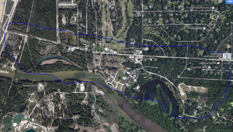
 TexasOma: My comment was a generalization. Forest Cove is not flat, so some houses were spared in the section closer to the river. Generally, though, you can draw a lasso around the areas closer to Hamblen (and some further away from the river where it dips down, hence my comment about Magnolia/Sycamore). See area on blue on this picture. My point was that the Forest Cove townhomes were decimated in 1994.Â
 4951
That bend will do that (over time there would probably be an oxbow form through there from overflow cutting through... its natural delta formation except it's occurring at the head of the lake instead of the bay/coastline. You're not going to stop it bc drains/creeks/etc feeding the rivers will naturally get larger too and put more sediment in the stream systems. Retaining walls & dredging is about the only thing you can do. 4951
I was talking with my parents this past weekend about the topic of flooding along the San Jacinto, and they told me the San Jacinto was bad about flooding, and silty sand bars in 1960! I don't mean FM 1960, I mean the YEAR 1960, as they boated, fished and water skied on the river when they were in high school and after. My dad said that the river was constantly changing where the sand bars and shallow spots were, submerged logs were always an issue, and the water was always sandy. I'm sure the upstream development and businesses haven't helped, but this is not a new phenomenon for the river or Lake Houston. I wonder just how much sand and silt could be dredged out of the lake. I know they periodically dredge parts of the Intracoastal Waterway, and it is extremely expensive. Sometimes they pump the sand to spoil islands and other times they pump it offshore. 4951
I'm no rocket scientist but even I know what's causing all the flooding in Kingwood... RAIN Funny, it never flooded in Kingwood when it didn't rain a lot. DUH!!!!! 4951
- - - - - - - -
>> Here is a very good example:
Impact to townhouses located on the San Jac River in Forest Cove:
2008. 62.80 ft. 0 ft
2016. 61.90 ft. 7 ft
This is an issue that needs to be addressed.
KWKayaker: Check 1994. Water was higher, and every home and garage in Forest Cove south of about Magnolia or Sycamore flooded, all of it. River peaked at about 66 feet at the 59 bridge. buffaloglenn:
What was the pool level of the lake then (2008)? 4951
That bend will do that (over time there would probably be an oxbow form through there from overflow cutting through...
 podunk: My guess is that oxbow was originally part of the West Fork. Then during a high flow situation, the river cut a straighter path, leaving that oxbow as a result.It is pretty common for rivers to change paths over time. If you closely follow the Mississippi and Louisiana border, it originally followed the middle of the river. Now, the river has created oxbows and has moved so much that the border is often on dry land.
 ieces of LA and MS are now on opposite sides of the river. When young, we often fished in two oxbows from the Mississippi River near Baton Rouge: False River and Old River.When living in Louisiana, there were concerns that the Mississippi River might change course from well north of Baton Rouge and divert over to the Atchafalaya Spillway/Basin. This would have left the ports of Baton Rouge and New Orleans dry. Backflow of salt water from the Gulf might save the NO port, but BR would dry up. The Corps of Engineers have been working to prevent this from happening for several decades.
4951
Mother nature will prevail in the end. In the meantime you and I will pay for various projects the Corps of Retired Engineers are doing to "control" natural river systems and you and I will pay for it with federal aid when the levees fail, and they will, ala Katrina. 4951
- - - - - - - -
>> That bend will do that (over time there would probably be an oxbow form through there from overflow cutting through...
podunk: Â My guess is that oxbow was original part of the West Fork. Â Then during a high flow situation, the river cut a straighter path, leaving that oxbow as a result.It is pretty common for rivers to change paths over time. Â If you closely follow the Mississippi and Louisiana border, it originally followed the middle of the river. Â Now, the river has created oxbows and has moved so much that the border is often on dry land. Â Pieces of LA and MS are now on opposite sides of the river. Â When young, we often fished in two oxbows from the Mississippi River near Baton Rouge: Â False River and Old River.When living in Louisiana, there were concerns that the Mississippi River might change course from well north of Baton Rouge and divert over to the Atchafalaya Spillway/Basin. Â This would have left the ports of Baton Rouge and New Orleans dry. Â Backflow of salt water from the Gulf might save the NO port, but BR would dry up. Â The Corps of Engineers have been working to prevent this from happening for several decades. Retired_Engineer:
Mother nature will prevail in the end. In the meantime you and I will pay for various projects the Corps of Retired Engineers are doing to "control" natural river systems and you and I will pay for it with federal aid when the levees fail, and they will, ala Katrina.
 choclab: Â Now why would you call it the Corps of RETIRED Engineers? Â If they were retired, do you think they would give a crap?Other than that, I agree with you. Â Mother Nature will prevail and there is only so much man can do. Â Some of the efforts of the Corps of Engineers ARE reasonably successful, such as the Bonnet Carrie Spillway upstream from New Orleans. Â If the Mississippi River level increases to the point that it threatens New Orleans, they divert a good portion of the river to the Pontchartrain Lake and Gulf.However, when the level of the river gets that high, there still could be levee failures. Â I would rather have the levees and have an occasional failure than not have levees and flood most of south Louisiana every spring.
4951
After reading this thread I too was curious about the bright blue "lake" north of Mills Branch. It seems the property is run by Hallett Materials. According to their web site they "provide stabilized sand, concrete sand and construction sand for Houston and the surrounding areas." I apologize if this is a repeat from an earlier comment. 4951
After reading this thread I too was curious about the bright blue "lake" north of Mills Branch. It seems the property is run by Hallett Materials. According to their web site they "provide stabilized sand, concrete sand and construction sand for Houston and the surrounding areas." I apologize if this is a repeat from an earlier comment.
Boca1723: Good info! I suspect that the blue water may be the result of the use of a flocculant that helps bond the suspended clay particles together so they settle out or can be filtered out. However, without knowing more, I would NOT let my kids swim in the blue water. 4951
These sand mining operations brings up another possible concern. They are removing sand and clay from some depth in the ground. In effect, they are creating a void in the ground. If enough material is taken out, ground sinking or sink holes could result. It all depends on how much material they are taking out, how long have they been doing it, and what kind of substrata layers are above their voids. I would think/hope that any problems would remain near their mining operation, but you can't be sure.I'm sure if you go deep enough, you will find rock substrata. When I worked upstream of New Orleans, the ground was even worse than here. We had storage tanks that had settled three feet into the ground. We had a geological survey done to see if it was reasonable to reach a rock layer with piles for a foundation. There were several rock substrata, but they were much too deep for piles. We still used piles but lots more of them and pounded them into the ground until they would not go any further. 4951
This discussion has been locked.
« Back to ChatViews: 4,398
# Replies: 54