


Updated storm forecast
Updated storm forecast


Joined:
X days ago
# Posts:
X,XXX
Contributor Points:
X


Updated storm forecast In terms of storms and timing, here's how we think this weekend's weather will unfold. Eric Berger · Thursday, March 5, 2026 7:08 AM In brief: *In today's post we discuss the recent and ongoing sea fog as well as our warmer than usual temperatures.
*Then our attention turns to the likelihood of storms this weekend as a front sags into Houston and brings much needed rain. THURSDAY - *Cloudy skies this morning will give way to partly sunny skies this afternoon.
*High temperatures likely topping out in the low to mid 80s but this will depend on the extent of sunshine at your location.
*We did see a few very light sprinkles on Wednesday in parts of Houston, but I feel like, overall, our chances for rain today will be pretty close to zero.
*Humidity levels will remain rather high for this time of year. FRIDAY - *This day will be rather similar to Thursday, with two possible changes.
*First of all, those southerly winds might be even a little bit stronger, gusting up to possibly 30 mph from the south during the afternoon.
*The other difference is that there is perhaps a 30 percent chance of light showers during the daytime or evening.
*Lows, again, will be very warm for early March. 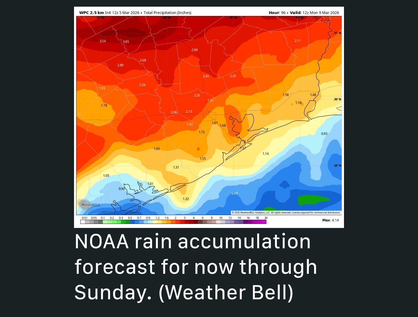 SATURDAY and SUNDAY - So will the weekend bring a rain-o-rama? It's still a little difficult to pin down precise details, but roughly speaking here's what I think will happen. *Saturday will be another warm and humid day like those preceding it.
*There will be a better chance of light daytime showers, perhaps on the order of 30 percent.
*I don't expect these to be significant or disruptive.
*On Saturday afternoon (or early evening) a dying cold front is going to approach and potentially move into the Houston metro area.
*I expect there to be a goodly number showers and thunderstorms with this front.
*Whether these storms make it all the way to the coast will depend on where the front stalls, but at this point I think there is a decent chance of everyone seeing some rain.
*I'm hopeful, for the purposes of our spring vegetation, that we pick up 0.5 to 2 inches this weekend, with higher isolated totals. Again some uncertainty remains. 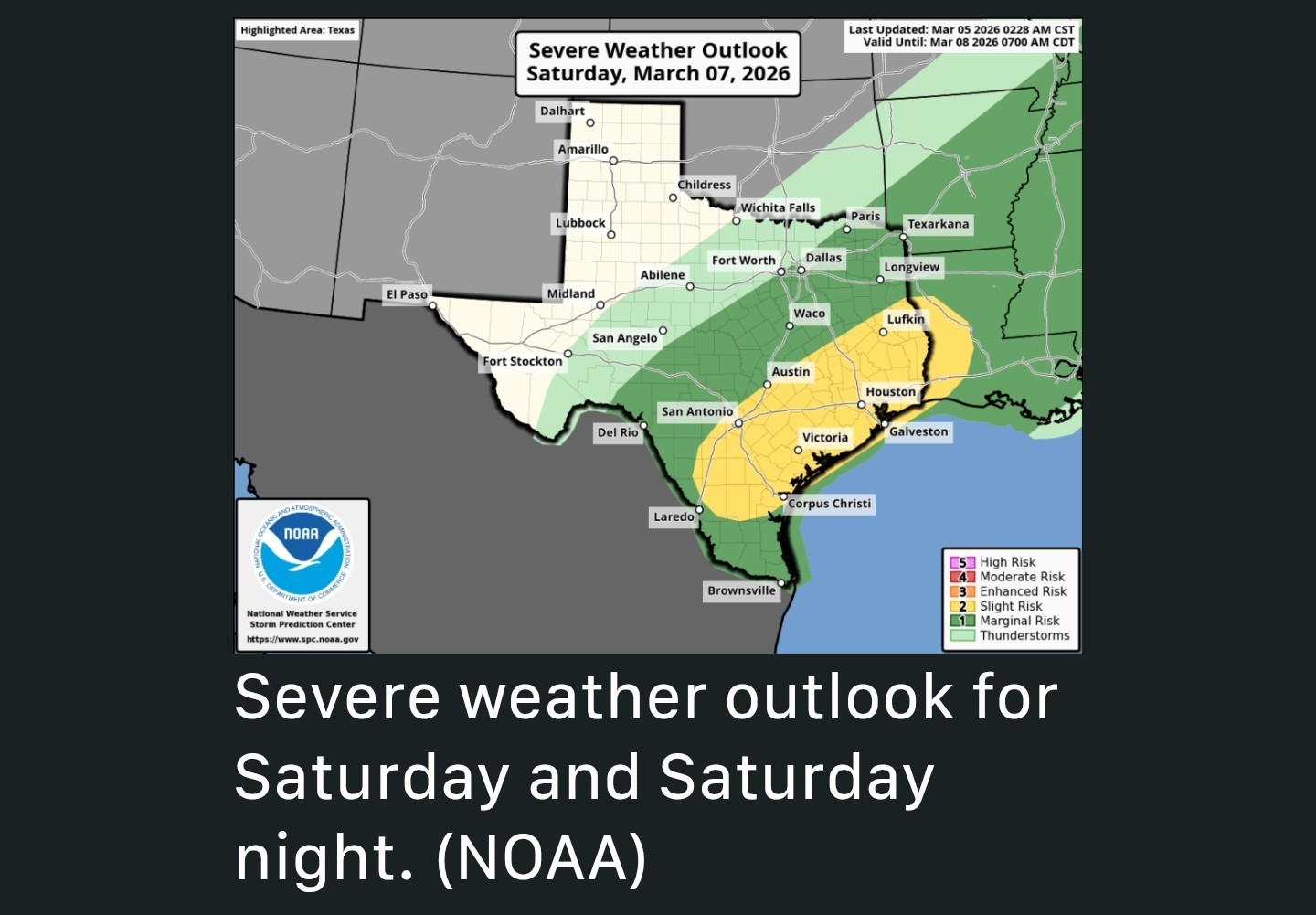 *I mentioned thunderstorms and there is slight risk for some severe weather with this front as it moves in and stalls, and again I think the most likely timing for this is probably Saturday evening.
*So bear that in mind if you're planning to be out and about. *Sunday, for much of the region, should be a few degrees cooler due to widespread cloud cover, the aforementioned front, and ongoing rain chances during the day.
*The potential for thunderstorms and severe weather should be diminished however. ❗️The bottom line is that from Saturday afternoon into Sunday morning we're going to need to be mindful of the possibility of thunderstorms and heavy rainfall. I'm not saying everyone will see these conditions but the chance is there.


buffaloglenn, bb1976 and CatalinaKitKat + 8 more reacted *Then our attention turns to the likelihood of storms this weekend as a front sags into Houston and brings much needed rain.
*********************
*High temperatures likely topping out in the low to mid 80s but this will depend on the extent of sunshine at your location.
*We did see a few very light sprinkles on Wednesday in parts of Houston, but I feel like, overall, our chances for rain today will be pretty close to zero.
*Humidity levels will remain rather high for this time of year.
*First of all, those southerly winds might be even a little bit stronger, gusting up to possibly 30 mph from the south during the afternoon.
*The other difference is that there is perhaps a 30 percent chance of light showers during the daytime or evening.
*Lows, again, will be very warm for early March.
*There will be a better chance of light daytime showers, perhaps on the order of 30 percent.
*I don't expect these to be significant or disruptive.
*On Saturday afternoon (or early evening) a dying cold front is going to approach and potentially move into the Houston metro area.
*I expect there to be a goodly number showers and thunderstorms with this front.
*Whether these storms make it all the way to the coast will depend on where the front stalls, but at this point I think there is a decent chance of everyone seeing some rain.
*I'm hopeful, for the purposes of our spring vegetation, that we pick up 0.5 to 2 inches this weekend, with higher isolated totals.
*So bear that in mind if you're planning to be out and about.
*The potential for thunderstorms and severe weather should be diminished however.
Replies:

ughhhh going to the Rodeo Saturday... I hope the weather holds for us.
StormChaser, Kittle and cbear reacted

|
Kaylagirl : Is something special happening that day?
|
|
StormChaser : StormChaser : I just need April 12th to be nice...lol.
Kaylagirl : Is this your birthday friend?
|
|
peppermintstick : cbear : Hubby and I are going to renew our vows! Long overdue. We have been through a lot the last few years and are trying to rebuild our lives and relationship.
peppermintstick : cbear : Hubby and I are going to renew our vows! Long overdue. We have been through a lot the last few years and are trying to rebuild our lives and relationship.peppermintstick tipped Kaylagirl 100 credits for a post in this forum discussion.
|
|
Kaylagirl : I think that's wonderful. I'll pray we have a beautiful day. Is it going to be outside somewhere?
|
|
peppermintstick : You are so sweet!!! Thanks for the nice tip and the prayers. You are an awesome lady!!!
 KanKan
|
|
StormChaser : Thank you for sharing this forecast. I'm looking forward to getting some rain this weekend, and I hope it will be enough to help with the drought, but not so much that there is flooding anywhere.
Updated storm forecast In terms of storms and timing, here's how we think this weekend's weather will unfold. Eric Berger · Thursday, March 5, 2026 7:08 AM In brief: *In today's post we discuss the recent and ongoing sea fog as well as our warmer than usual temperatures.
*Then our attention turns to the likelihood of storms this weekend as a front sags into Houston and brings much needed rain. THURSDAY - *Cloudy skies this morning will give way to partly sunny skies this afternoon.
*High temperatures likely topping out in the low to mid 80s but this will depend on the extent of sunshine at your location.
*We did see a few very light sprinkles on Wednesday in parts of Houston, but I feel like, overall, our chances for rain today will be pretty close to zero.
*Humidity levels will remain rather high for this time of year. FRIDAY - *This day will be rather similar to Thursday, with two possible changes.
*First of all, those southerly winds might be even a little bit stronger, gusting up to possibly 30 mph from the south during the afternoon.
*The other difference is that there is perhaps a 30 percent chance of light showers during the daytime or evening.
*Lows, again, will be very warm for early March. SATURDAY and SUNDAY - So will the weekend bring a rain-o-rama? It's still a little difficult to pin down precise details, but roughly speaking here's what I think will happen. *Saturday will be another warm and humid day like those preceding it.
*There will be a better chance of light daytime showers, perhaps on the order of 30 percent.
*I don't expect these to be significant or disruptive.
*On Saturday afternoon (or early evening) a dying cold front is going to approach and potentially move into the Houston metro area.
*I expect there to be a goodly number showers and thunderstorms with this front.
*Whether these storms make it all the way to the coast will depend on where the front stalls, but at this point I think there is a decent chance of everyone seeing some rain.
*I'm hopeful, for the purposes of our spring vegetation, that we pick up 0.5 to 2 inches this weekend, with higher isolated totals. Again some uncertainty remains. *I mentioned thunderstorms and there is slight risk for some severe weather with this front as it moves in and stalls, and again I think the most likely timing for this is probably Saturday evening.
*So bear that in mind if you're planning to be out and about. *Sunday, for much of the region, should be a few degrees cooler due to widespread cloud cover, the aforementioned front, and ongoing rain chances during the day.
*The potential for thunderstorms and severe weather should be diminished however. ❗️The bottom line is that from Saturday afternoon into Sunday morning we're going to need to be mindful of the possibility of thunderstorms and heavy rainfall. I'm not saying everyone will see these conditions but the chance is there.
*Then our attention turns to the likelihood of storms this weekend as a front sags into Houston and brings much needed rain.
*********************
*High temperatures likely topping out in the low to mid 80s but this will depend on the extent of sunshine at your location.
*We did see a few very light sprinkles on Wednesday in parts of Houston, but I feel like, overall, our chances for rain today will be pretty close to zero.
*Humidity levels will remain rather high for this time of year.
*First of all, those southerly winds might be even a little bit stronger, gusting up to possibly 30 mph from the south during the afternoon.
*The other difference is that there is perhaps a 30 percent chance of light showers during the daytime or evening.
*Lows, again, will be very warm for early March.
*There will be a better chance of light daytime showers, perhaps on the order of 30 percent.
*I don't expect these to be significant or disruptive.
*On Saturday afternoon (or early evening) a dying cold front is going to approach and potentially move into the Houston metro area.
*I expect there to be a goodly number showers and thunderstorms with this front.
*Whether these storms make it all the way to the coast will depend on where the front stalls, but at this point I think there is a decent chance of everyone seeing some rain.
*I'm hopeful, for the purposes of our spring vegetation, that we pick up 0.5 to 2 inches this weekend, with higher isolated totals.
*So bear that in mind if you're planning to be out and about.
*The potential for thunderstorms and severe weather should be diminished however.
@CatalinaKitKat tipped
StormChaser 100 credits for a post in this forum discussion.
|
|
peppermintstick : I will post afterwards where we did it. Not that anyone would be bored enough to stalk us lol, but I am very private IRL. I am nervous and excited.
« Back to Chat
Views: 796
# Replies: 24