


Space City winter weather forecast
Space City winter weather forecast


Joined:
X days ago
# Posts:
X,XXX
Contributor Points:
X


Space City winter weather forecast As of right now, Space City is forecasting that the worst of the winter weather should stay north of Highway 105. BUT - we could definitely see icy roadways on Saturday afternoon, evening & on Sunday if the roads are wet enough from the rainfall earlier in the day. We cound also see freezing rain overnight Saturday. Sunday AM will likely get down to the low 20s in Kingwood 🥶 Depending on if we get above freezing on Sunday, we may have issues on the roadways on Sunday as well. Monday AM may still have some icy roadways but we will finally get above freezing. Again, a lot of this is still a waiting game to see: #1 Exactly when the precipitation arrives.
#2 What the temperatures are at that time. We should have better confidence in the next 48 hours. ‼️ Regardless of precip, I definitely recommend getting things prepped around the house for a very hard freeze starting Saturday afternoon. Pipes, pools, sprinkler systems, plants - all that good stuff needs to be protected. I'll update y'all as needed 😊 ......... From Space City Weather: With an Arctic front firmly in the forecast, the question remains whether Houston sees cold rain or freezing rain this weekend. Eric Berger · Tuesday, January 20, 2026 6:39 AM In brief: It will be warm in Houston this week until it's not. *An Arctic front will arrive on Friday night and drive temperatures down to their coldest level of the season.
*We are tracking the dual threats of a hard freeze this weekend as well as the potential for freezing rain and icy roads. Buckle up y'all, because it is winter storm season! Winter storm potential - *The state of Texas faces the potential for a significant winter storm this week beginning Friday evening, and lasting into much of the weekend.
*This will be driven by an Arctic front surging into the southern United States, bringing the coldest air of the season down into Texas.
*This front will also bring a decent shot of lingering precipitation, and for the northern half of Texas this will mean a mix of snow, freezing rain, and sleet.
*Expect significant mobility issues in the metro areas of Dallas-Fort Worth and Austin, and possibly San Antonio. *As for Houston, the outlook is less certain. We are going to get very cold air, and almost certainly a freeze by Saturday evening.
*It is not clear whether the freezing temperatures will arrive before the showers end.
*I think it is highly likely that areas along and north of Highway 105 (which runs from Navasota to Conroe to Cleveland) will see freezing rain on Saturday or Saturday night.
*While there is clearly the potential for freezing rain further south, in the Houston metro area, we cannot yet say so for sure. 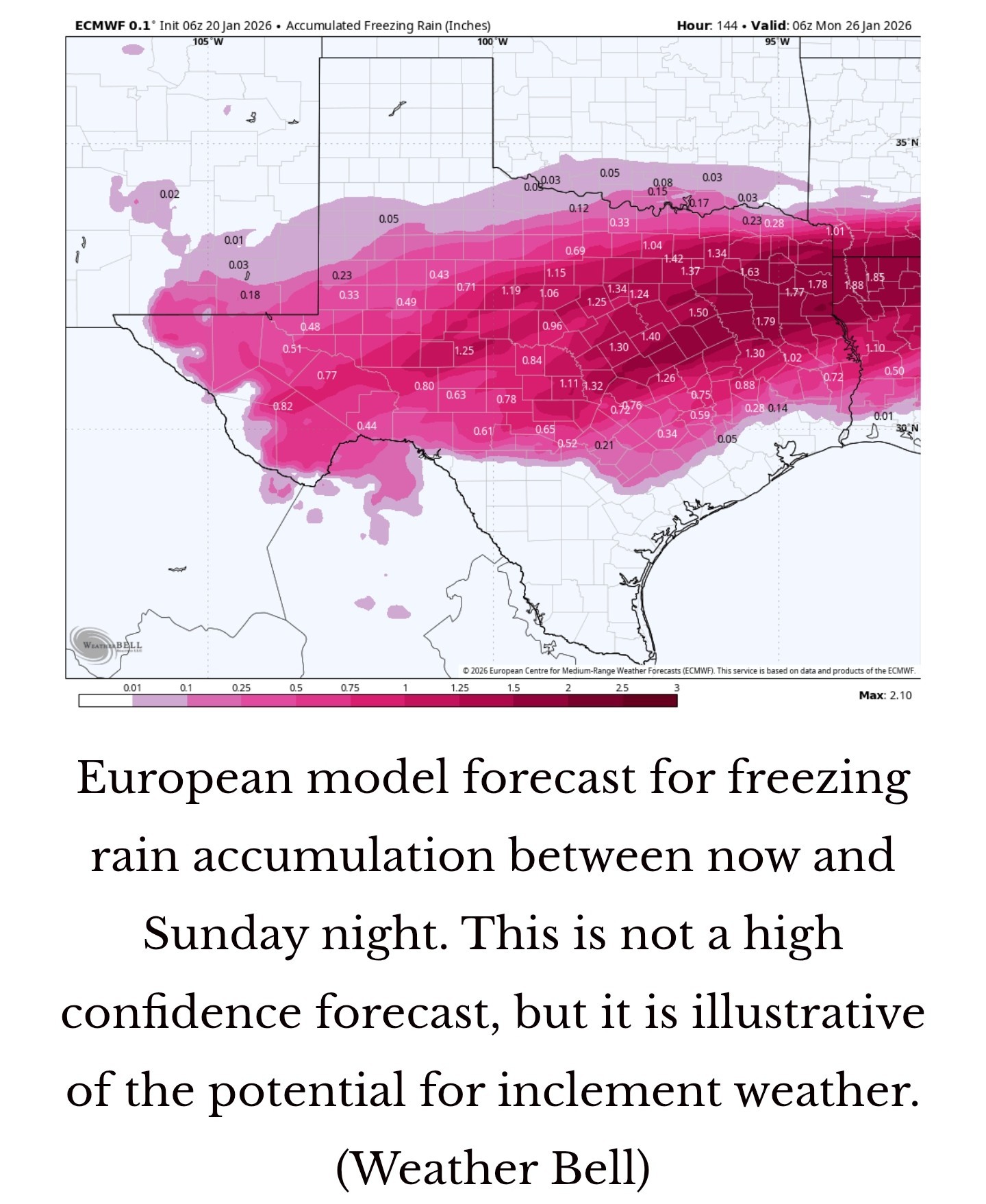 *What we can tell you with confidence this morning is that travel north and west of Houston, beginning Friday evening, will start to become hazardous.
*There is the potential for icy roads in Houston itself on Saturday, Saturday night, and Sunday.
*You also should begin to take precautions for a possible hard freeze, in which temperatures fall below 25 degrees.
*This is not a certainty, but it is a possibility for all but coastal areas. Tuesday - *If you prefer partly sunny skies and mild temperatures, then today is the day for you.
*There will be a brief window this afternoon when I think we'll see a decent amount of sunshine, with temperatures rising into the mid- to upper 60s.
*Winds will be light, from the east.
*Lows tonight will be warmer than we've been experiencing, in the upper 50s. Wednesday - *A weak front will sag into the area on Wednesday and die, and this will bring us mostly cloudy skies and a healthy chance of widespread, light rain.
*I don't expect serious accumulations, but many areas will likely pick up a few tenths of an inch of precipitation.
*Temperatures, otherwise, will be about 70 degrees with modestly humid air.
*Lows on Wednesday night will only drop to about 60 degrees.
*As a result, some fog will be possible early Thursday. Thursday - *This will be another mild day with highs around 70 degrees (or perhaps a bit warmer) with mostly cloudy skies.
*There will be a slight chance of showers.
*Expect another warm night, with lows only in the range of 60 degrees. Friday - *This will be our third cloudy, warm-ish day in a row, with highs likely in the low 70s.
*By Friday evening, the Arctic front will be dropping our way. This should support the development of some rain showers during the afternoon and overnight period.
*Lows on Friday night will drop into the 40s. 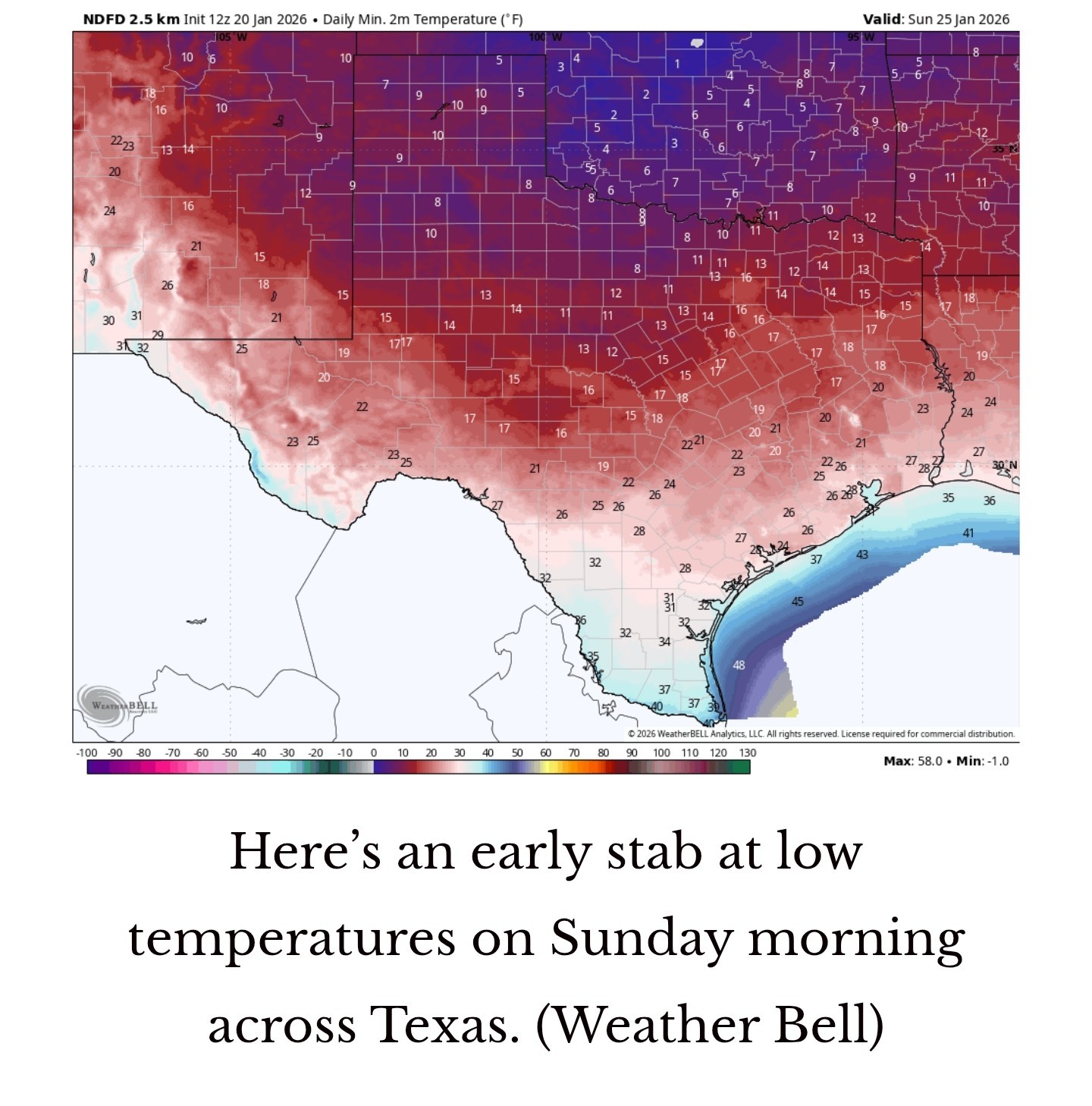 Saturday - *This will be a cold and gray day, with a healthy chance of rainfall.
*Depending on how cold it is at various locations, but especially north of Interstate 10, we may start to see some freezing precipitation.
*I think for areas in Montgomery County and points north, air temperatures may reach freezing early on Saturday, so that's why we have concerns about freezing rain.
*A more widespread freeze is likely in Houston and surrounding suburbs by Saturday afternoon or evening, and if the roads are wet they would freeze.
*Additionally, some light precipitation remains possible on Saturday night, and this would likely take the form of freezing rain. *The bottom line is that there is the potential for slick streets north of Houston on Friday night, and in the city itself beginning Saturday afternoon or evening.
*We will be watching this closely, of course, as the difference between rain and freezing rain is but a degree or two.
*Lows on Saturday night will probably drop into the mid to upper 20s in Houston on Saturday night, but there remains a large dollop of uncertainty there. Sunday - *I think this will be partly sunny day, so I'm hopeful that air temperatures will climb above freezing area-wide by around noon, but I'm not confident this will be the case.
*It will be a cold day regardless, with highs likely in the 30s.
*Again, we are going to have to monitor the potential for icy streets depending on how much moisture is left on roads, and whether there's any additional light precipitation on Sunday (maybe a 10 or 20 percent chance).
*Lows on Sunday night will probably be similar to Saturday night, dropping into the 20s.
*Will it be low mid- or upper 20s for Houston? Probably closer to the latter, but I'm not confident yet. Monday - *Temperatures should rebound a little bit by Monday, with mostly sunny skies, and reaching perhaps 40 degrees.
*This should end the threat of icy roads, but we cannot rule out impacts on Monday morning. Stay tuned. Next week - There's still some division among the various models, but most likely we will see a stretch of sunnier weather, with highs in the 40s and 50s, and lows at or above freezing. We'll see.


smokey545, Miro2019 and Wingsofwonder + 15 more reacted #2 What the temperatures are at that time.
*We are tracking the dual threats of a hard freeze this weekend as well as the potential for freezing rain and icy roads.
*This will be driven by an Arctic front surging into the southern United States, bringing the coldest air of the season down into Texas.
*This front will also bring a decent shot of lingering precipitation, and for the northern half of Texas this will mean a mix of snow, freezing rain, and sleet.
*Expect significant mobility issues in the metro areas of Dallas-Fort Worth and Austin, and possibly San Antonio.
*It is not clear whether the freezing temperatures will arrive before the showers end.
*I think it is highly likely that areas along and north of Highway 105 (which runs from Navasota to Conroe to Cleveland) will see freezing rain on Saturday or Saturday night.
*While there is clearly the potential for freezing rain further south, in the Houston metro area, we cannot yet say so for sure.
*There is the potential for icy roads in Houston itself on Saturday, Saturday night, and Sunday.
*You also should begin to take precautions for a possible hard freeze, in which temperatures fall below 25 degrees.
*This is not a certainty, but it is a possibility for all but coastal areas.
*There will be a brief window this afternoon when I think we'll see a decent amount of sunshine, with temperatures rising into the mid- to upper 60s.
*Winds will be light, from the east.
*Lows tonight will be warmer than we've been experiencing, in the upper 50s.
*I don't expect serious accumulations, but many areas will likely pick up a few tenths of an inch of precipitation.
*Temperatures, otherwise, will be about 70 degrees with modestly humid air.
*Lows on Wednesday night will only drop to about 60 degrees.
*As a result, some fog will be possible early Thursday.
*There will be a slight chance of showers.
*Expect another warm night, with lows only in the range of 60 degrees.
*By Friday evening, the Arctic front will be dropping our way. This should support the development of some rain showers during the afternoon and overnight period.
*Lows on Friday night will drop into the 40s.
*Depending on how cold it is at various locations, but especially north of Interstate 10, we may start to see some freezing precipitation.
*I think for areas in Montgomery County and points north, air temperatures may reach freezing early on Saturday, so that's why we have concerns about freezing rain.
*A more widespread freeze is likely in Houston and surrounding suburbs by Saturday afternoon or evening, and if the roads are wet they would freeze.
*Additionally, some light precipitation remains possible on Saturday night, and this would likely take the form of freezing rain.
*We will be watching this closely, of course, as the difference between rain and freezing rain is but a degree or two.
*Lows on Saturday night will probably drop into the mid to upper 20s in Houston on Saturday night, but there remains a large dollop of uncertainty there.
*It will be a cold day regardless, with highs likely in the 30s.
*Again, we are going to have to monitor the potential for icy streets depending on how much moisture is left on roads, and whether there's any additional light precipitation on Sunday (maybe a 10 or 20 percent chance).
*Lows on Sunday night will probably be similar to Saturday night, dropping into the 20s.
*Will it be low mid- or upper 20s for Houston? Probably closer to the latter, but I'm not confident yet.
*This should end the threat of icy roads, but we cannot rule out impacts on Monday morning.
Replies:

|
lol I like this comment the best…
" It will be warm in Houston this week until it's not."
Rolnwithmyhomie, peppermintstick and CatalinaKitKat + 6 more reacted " It will be warm in Houston this week until it's not."
|
|
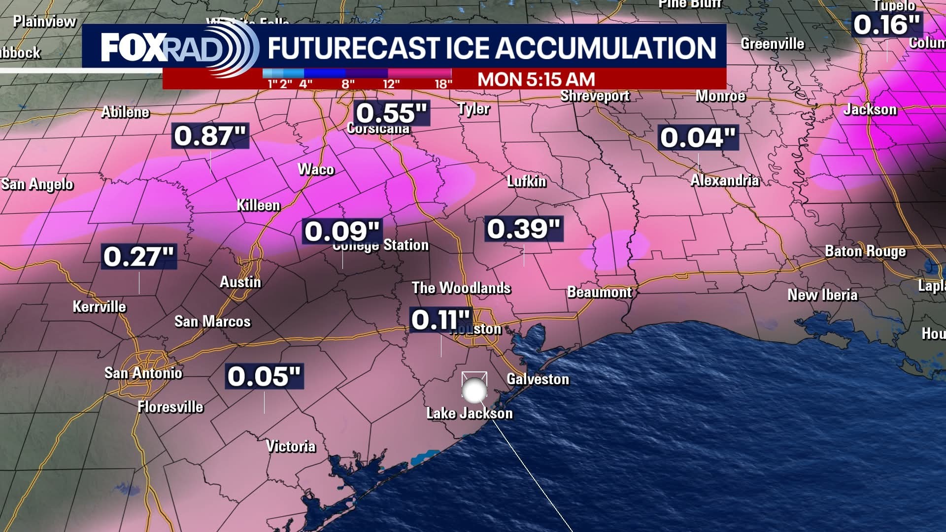
Newest GFS & EURO models are definitely not in agreement yet. The EURO has been a bit more reliable in the past but that's not to say the GFS will be wrong. 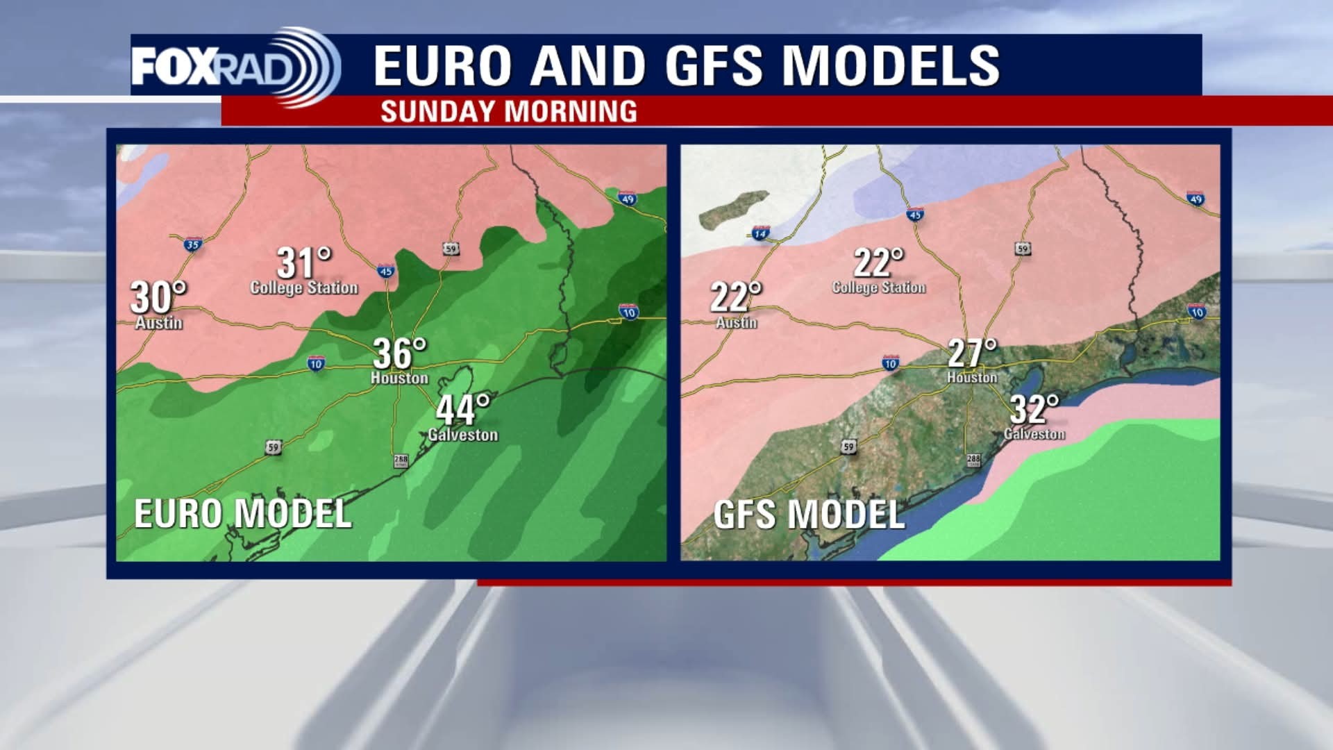 This is what we don't want; ice accumulations. 🧊 This has us getting around a tenth of an inch (or more)
AggieBandMom, SteveT and cbear reacted


I have to go to katy Saturday night 😞
Rolnwithmyhomie, peppermintstick and HappyDay2016 + 2 more reacted
|
|
Newest GFS & EURO models are definitely not in agreement yet. The EURO has been a bit more reliable in the past but that's not to say the GFS will be wrong. This is what we don't want; ice accumulations. 🧊 This has us getting around a tenth of an inch (or more)
StormChaser : I went out and bought a space heater yesterday. My shower is all tile and glass and it is already cold so, I bought it to warm things up on these 20 degree mornings etc. My pipes stay wrapped so I just need to pile some blankets over top, drip faucets and run the pool motor continuously until it gets back over 32.
StormChaser : Oh thank goodness! Looks like I will get home from my trip on Thursday night before all of this hits. Dallas is going to be a mess! Do not want to get stuck there!
As with a hurricane, a very slight difference in the storm's intensity and track will make all the difference. We could be frozen over with a glaze of ice, have nothing but cold rain -- or have virtually no precipitation at all, just cold air. We may just have to wait & see.
teatime, peppermintstick and SteveT + 2 more reacted
|
|
StormChaser : Thank you for the forecast and updates as usual. Time to get ready to hibernate for the weekend. If we don't have what we want in our house by Friday, we don't need it. Lol. I am not looking forward to any of this, at all.
|
|
StormChaser : Oh thank goodness! Looks like I will get home from my trip on Thursday night before all of this hits. Dallas is going to be a mess! Do not want to get stuck there!
bigla : Yikes!! You are right. I would have for you to get stuck up there in that mess! Safe travels friend!
|
|
I have to go to katy Saturday night 😞
Txbutterfly :
|
|
As with a hurricane, a very slight difference in the storm's intensity and track will make all the difference. We could be frozen over with a glaze of ice, have nothing but cold rain -- or have virtually no precipitation at all, just cold air. We may just have to wait & see.
jwardl :
|
|
Jeff Lindner. I like him and his forecasts so here's his take. 1-20-26 650am Arctic Front will arrive across Texas on Friday
A significant winter storm will likely impact large portions of the state this weekend
Very cold temperatures and wind chills likely this weekend
Winterization protection measures for hard freezes and prolonged cold should be completed by Friday afternoon.
Strong arctic cold front driven by sprawling surface high pressure in the 1048-1051mb range will move out of Canada late this week with the boundary arriving in Texas on Friday. Classic arctic front will progress across the state on Friday with significant post frontal temperature falls and rapid advancement of the freezing line southward. Front looks to reach SE TX in the evening hours on Friday, but this may be too slow given these fronts tend to move south faster than guidance suggests (probably wont have a better idea on frontal timing until Thursday when we get into range of the high resolution guidance). Temperatures will quickly fall Friday night into Saturday morning with the freezing line advancing toward the Columbus to Conroe corridor by sunrise on Saturday…this also may need to be adjusted southward some in the coming days. Cold air continues to pour southward Saturday with likely slowly falling temperatures through the day with the freezing line advancing toward the I-10 corridor Saturday evening and likely toward the coast by Sunday morning. Again…will need to watch temperature trends closely as this current timeline could be too slow bringing the freezing line south.
Hard freezes look increasing likely for areas north of I-10 Sunday AM and for a larger part of the area Mon AM including the Houston metro area. National Blend of Models has continued a slow decrease in both highs and lows for this period with potential for mid to upper 20's Sunday AM for much of the metro area and low 20's Mon AM (see graphics below). Highs on Sunday may struggle to reach the mid 30's and this would only be for a few hours…some places will likely not reach above freezing on Sunday…yielding a prolonged period of sub-freezing temperatures. Wind chills Saturday into Sunday are likely to fall into the 10's and 20's across much of the area with north winds of 10-20mph.
Precipitation:
A significant winter storm looks to impact much of the state late Friday into Sunday with accumulations of ice and snow.
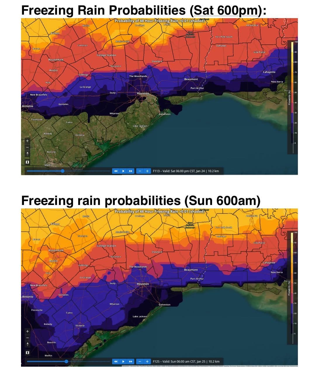
SE TX is likely to lie on the southern edge of an upcoming winter storm with widespread post frontal precipitation occurring from Friday night through Sunday morning. Forecast sounding suggest a warm layer of air above the cold dense surface air resulting in a profile favorable for the production of freezing rain where surface temperatures fall to 32 and below. By Saturday morning this line is roughly from Columbus to Conroe (maybe a bit further south) with locations north of this line potentially experiencing freezing rain and icing. Through the day Saturday into Saturday evening with the freezing line sinking southward the freezing rain/drizzle could move toward the I-10 corridor although there is a fair amount of uncertainty on how quickly the moisture begins to move out and does that happen before the surface air is cold enough to support freezing rain further southward into the metro area. For what it is worth at this point the National Blend of Models has freezing rain probabilities Saturday night into Sunday morning of 30-40% in NW Harris County and 20-30% as far south as the US 59 corridor (see graphics below).
It should be noted that travel across large portions of the state from late Friday through much of the weekend will become extremely dangerous due to winter precipitation accumulations and brutal cold.
Preparations:
Proper winterization of any exposed pipes/plumbing will be needed to prevent infrastructure damage. Sprinkler systems must be shut off and properly drained.
Pets/livestock will require proper shelter to protect from the cold temperatures and wind chills.
Tropical plants/vegetation will require maximum freeze protection. Unprotected tropical vegetation will be killed and even protect vegetation will likely suffer heavy damage.
Persons should limit outdoor exposure during the cold. Utilize heating sources properly to reduce the risk of fire and carbon monoxide poisoning.
All cold weather preparations should be completed by Friday afternoon prior to the arrival of the cold front. 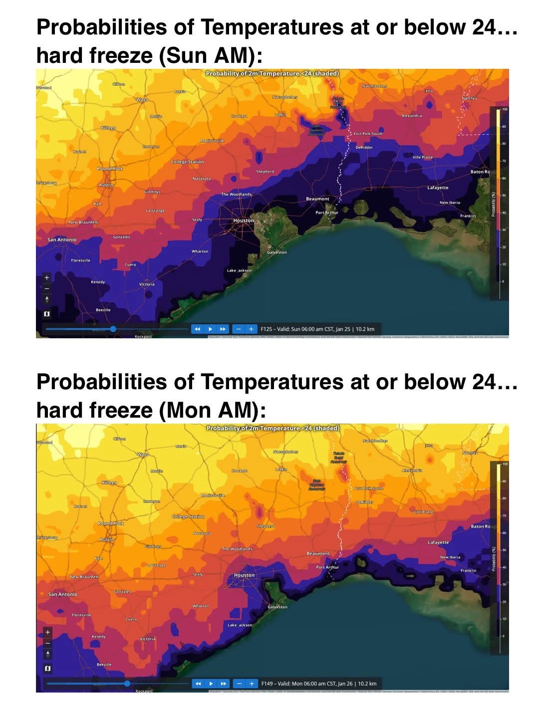
peppermintstick, AggieBandMom and HappyinTX reacted A significant winter storm will likely impact large portions of the state this weekend
Very cold temperatures and wind chills likely this weekend
Winterization protection measures for hard freezes and prolonged cold should be completed by Friday afternoon.
Strong arctic cold front driven by sprawling surface high pressure in the 1048-1051mb range will move out of Canada late this week with the boundary arriving in Texas on Friday. Classic arctic front will progress across the state on Friday with significant post frontal temperature falls and rapid advancement of the freezing line southward. Front looks to reach SE TX in the evening hours on Friday, but this may be too slow given these fronts tend to move south faster than guidance suggests (probably wont have a better idea on frontal timing until Thursday when we get into range of the high resolution guidance). Temperatures will quickly fall Friday night into Saturday morning with the freezing line advancing toward the Columbus to Conroe corridor by sunrise on Saturday…this also may need to be adjusted southward some in the coming days. Cold air continues to pour southward Saturday with likely slowly falling temperatures through the day with the freezing line advancing toward the I-10 corridor Saturday evening and likely toward the coast by Sunday morning. Again…will need to watch temperature trends closely as this current timeline could be too slow bringing the freezing line south.
Hard freezes look increasing likely for areas north of I-10 Sunday AM and for a larger part of the area Mon AM including the Houston metro area. National Blend of Models has continued a slow decrease in both highs and lows for this period with potential for mid to upper 20's Sunday AM for much of the metro area and low 20's Mon AM (see graphics below). Highs on Sunday may struggle to reach the mid 30's and this would only be for a few hours…some places will likely not reach above freezing on Sunday…yielding a prolonged period of sub-freezing temperatures. Wind chills Saturday into Sunday are likely to fall into the 10's and 20's across much of the area with north winds of 10-20mph.
Precipitation:
A significant winter storm looks to impact much of the state late Friday into Sunday with accumulations of ice and snow.
SE TX is likely to lie on the southern edge of an upcoming winter storm with widespread post frontal precipitation occurring from Friday night through Sunday morning. Forecast sounding suggest a warm layer of air above the cold dense surface air resulting in a profile favorable for the production of freezing rain where surface temperatures fall to 32 and below. By Saturday morning this line is roughly from Columbus to Conroe (maybe a bit further south) with locations north of this line potentially experiencing freezing rain and icing. Through the day Saturday into Saturday evening with the freezing line sinking southward the freezing rain/drizzle could move toward the I-10 corridor although there is a fair amount of uncertainty on how quickly the moisture begins to move out and does that happen before the surface air is cold enough to support freezing rain further southward into the metro area. For what it is worth at this point the National Blend of Models has freezing rain probabilities Saturday night into Sunday morning of 30-40% in NW Harris County and 20-30% as far south as the US 59 corridor (see graphics below).
It should be noted that travel across large portions of the state from late Friday through much of the weekend will become extremely dangerous due to winter precipitation accumulations and brutal cold.
Preparations:
Proper winterization of any exposed pipes/plumbing will be needed to prevent infrastructure damage. Sprinkler systems must be shut off and properly drained.
Pets/livestock will require proper shelter to protect from the cold temperatures and wind chills.
Tropical plants/vegetation will require maximum freeze protection. Unprotected tropical vegetation will be killed and even protect vegetation will likely suffer heavy damage.
Persons should limit outdoor exposure during the cold. Utilize heating sources properly to reduce the risk of fire and carbon monoxide poisoning.
All cold weather preparations should be completed by Friday afternoon prior to the arrival of the cold front.
|
|
StormChaser : Well finally started the heater just to make sure it's good to go. Will put covers over all outside faucets, left the water pipe wrapped so it's good. Already drained sprinklers. So I feel good about the prep work. Wrap the plants this weekend too. I'm not looking forward to driving 99 Grand Parkway Saturday
|
|
HappyDay2016 : I would think we should get ready Thursday evening or Friday morning, before the rains come. For now, rain showers possible on Friday, but steady rain coming that night.
 May change! Thank you, StormChaser!
|
|
When are you all covering your plants? On Thursday night?
HappyDay2016 : I'm covering plants on Friday afternoon « Back to Chat
Views: 2,287
# Replies: 50