


Severe weather update
Severe weather update


Joined:
X days ago
# Posts:
X,XXX
Contributor Points:
X


Severe weather update Looks like we'll now have 2 opportunities for severe storms today. ⏰️ Timing: 3-4PM this afternoon &
10-11PM tonight. The threat has increased a bit, but the worst of the weather is still expected to be to our north. Kingwood is not in the level 2 risk area (yellow in map #1) but we're close. If the sun doesn't come out today, our atmosphere will have a hard time getting storms going, so we'll see how that plays out. As always, I'll update as needed! Stay safe 💚 From Jeff Lindner: 01-09-2026
7:20am Severe threat has been increased north of the metro area. Most of the metro area is in a level 1 out of 5 risk with areas northwest in a level 2 out of 5. This includes areas from around Splendora ➡️ north. (See map #1) Photo #1:
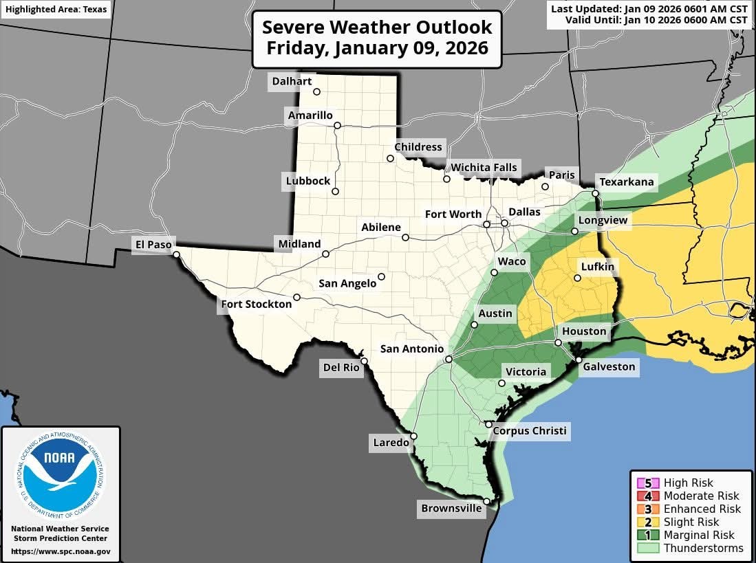 Main threats: Large hail.
Damaging winds.
Isolated tornado. 🌪 The higher tornado risk likely over Louisiana. Tornado;
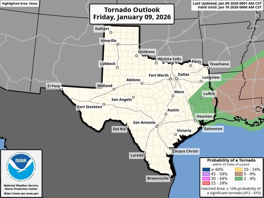 Wind:
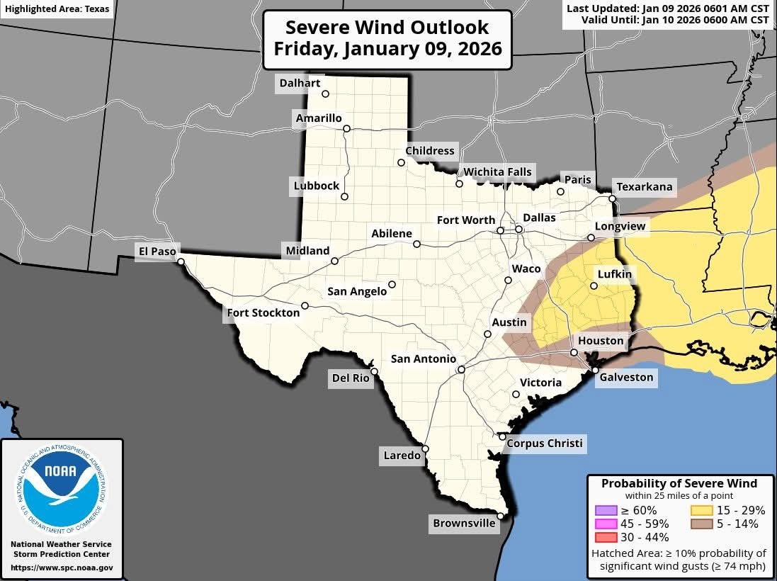 Hail:
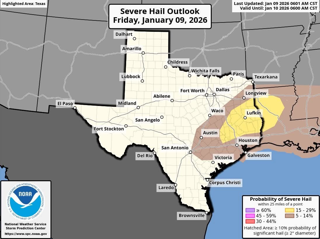 ☀️ Threat is somewhat conditional on the amount of heating today so the more sun and heating the higher the threat. ⏰️ Highest threat period will be from 3 to 4pm and 10-11pm tonight; coming from NW to SE over the area.


Wingsofwonder, HappyDay2016 and peppermintstick + 9 more reacted 10-11PM tonight.
7:20am
Damaging winds.
Isolated tornado.
Replies:

|
Severe weather update Looks like we'll now have 2 opportunities for severe storms today. ⏰️ Timing: 3-4PM this afternoon & 10-11PM tonight. The threat has increased a bit, but the worst of the weather is still expected to be to our north. Kingwood is not in the level 2 risk area (yellow in map #1) but we're close. If the sun doesn't come out today, our atmosphere will have a hard time getting storms going, so we'll see how that plays out. As always, I'll update as needed! Stay safe 💚 From Jeff Lindner: 01-09-2026 7:20am Severe threat has been increased north of the metro area. Most of the metro area is in a level 1 out of 5 risk with areas northwest in a level 2 out of 5. This includes areas from around Splendora ➡️ north. (See map #1) Photo #1: Main threats: Large hail. Damaging winds. Isolated tornado. 🌪 The higher tornado risk likely over Louisiana. Tornado; Wind: Hail: ☀️ Threat is somewhat conditional on the amount of heating today so the more sun and heating the higher the threat. ⏰️ Highest threat period will be from 3 to 4pm and 10-11pm tonight; coming from NW to SE over the area.
StormChaser : Thanks for the heads up.
|
|


Severe weather update Looks like we'll now have 2 opportunities for severe storms today. ⏰️ Timing: 3-4PM this afternoon & 10-11PM tonight. The threat has increased a bit, but the worst of the weather is still expected to be to our north. Kingwood is not in the level 2 risk area (yellow in map #1) but we're close. If the sun doesn't come out today, our atmosphere will have a hard time getting storms going, so we'll see how that plays out. As always, I'll update as needed! Stay safe 💚 From Jeff Lindner: 01-09-2026 7:20am Severe threat has been increased north of the metro area. Most of the metro area is in a level 1 out of 5 risk with areas northwest in a level 2 out of 5. This includes areas from around Splendora ➡️ north. (See map #1) Photo #1: Main threats: Large hail. Damaging winds. Isolated tornado. 🌪 The higher tornado risk likely over Louisiana. Tornado; Wind: Hail: ☀️ Threat is somewhat conditional on the amount of heating today so the more sun and heating the higher the threat. ⏰️ Highest threat period will be from 3 to 4pm and 10-11pm tonight; coming from NW to SE over the area.
StormChaser : Thank you!
|
|
StormChaser : Thanks for the heads up! Of course one of the threats is at the time the kids get out of school. Lol
|
|
Space City Weather Matt Lanza · Friday, January 9, 2026 8:52 AM In brief: *Scattered showers and thunderstorms are likely today with a couple storms possibly becoming a little on the stronger to severe side.
*Cooler air follows this weekend along with breezy conditions again.
*Temps stay more seasonable into next week. Today & Saturday - The area is highlighted in a marginal (1/5) and slight (2/5) risk for severe storms today, with the higher risks the farther north you go. *Today's severe threat is not a slam dunk case but rather somewhat of a conditional case. 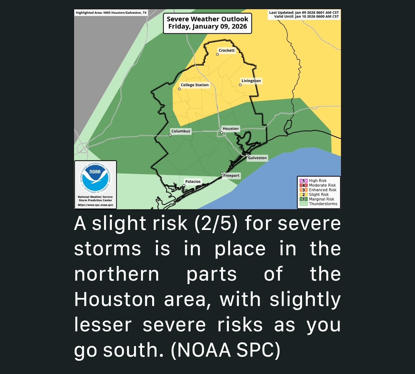 *In other words, not everyone is going to see severe weather, but if the right set of circumstances can come together, we will see a couple severe storms, particularly north of Houston.
*All severe modes are on the table today, but gusty winds and potential hail seem like the higher risks.
*The tornado risk has been highlighted more into northern Louisiana. *Look for scattered showers to pop up over the next few hours this morning.
*Round one of storms would potentially occur between about 11 AM and 4 PM with isolated storms lifting northward from Harris County or Waller County into Grimes, Montgomery, Walker, Liberty, and San Jacinto Counties.
*Those are the storms that could turn strong to severe in a couple locations.
*Things should quiet down before a broken line of thunderstorms moves across the entire region this evening, probably before midnight.
*With those storms, we don't expect severe weather but we will probably see some gusty winds and lightning.
*Also, given that it's a broken line of storms, some of you may not see anything at all.
*Let's hope most of us get a little rain today, as we need it! *It'll turn breezy tonight behind that front. The winds may lag the line of storms by a few hours, but by Saturday morning we should see 30-35 mph wind gusts across most of the area.
*A few 40 mph gusts are possible Saturday with the initial onset of winds.
*Winds should slow down a bit in the afternoon and evening. 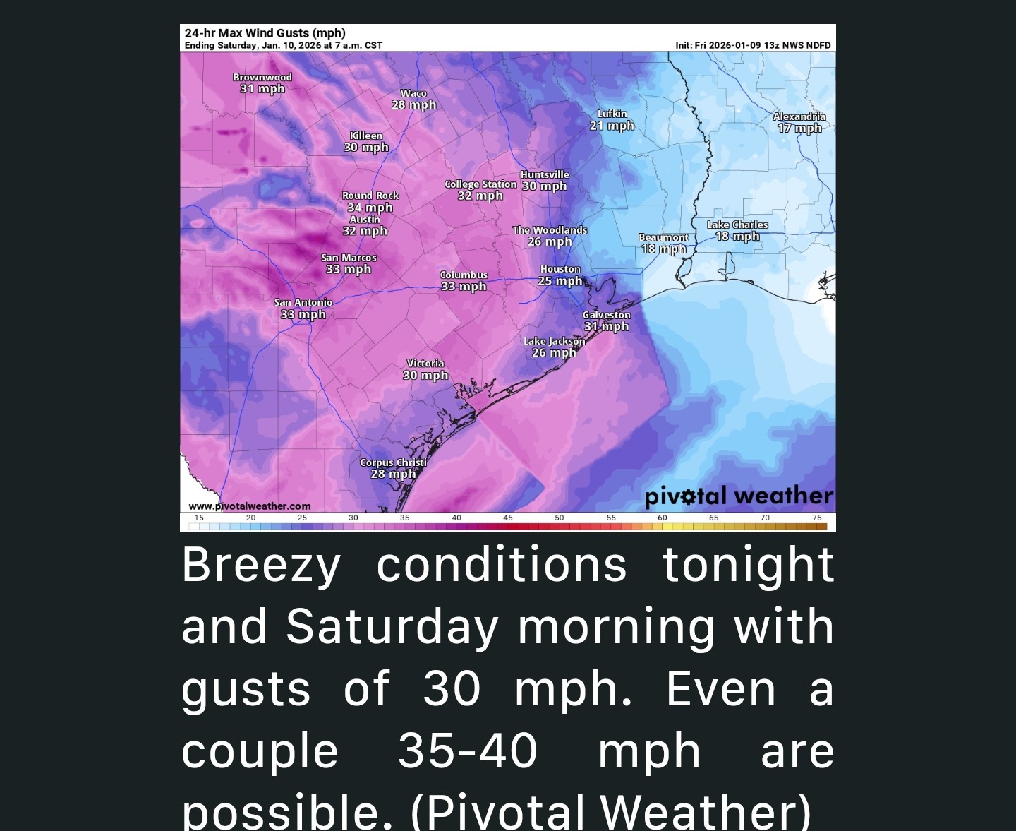 *Otherwise, expect cooler temperatures.
*After mid to upper 70s today, we'll drop into the 60s tonight and 50s for most of tomorrow.
peppermintstick reacted *Cooler air follows this weekend along with breezy conditions again.
*Temps stay more seasonable into next week.
*All severe modes are on the table today, but gusty winds and potential hail seem like the higher risks.
*The tornado risk has been highlighted more into northern Louisiana.
*Round one of storms would potentially occur between about 11 AM and 4 PM with isolated storms lifting northward from Harris County or Waller County into Grimes, Montgomery, Walker, Liberty, and San Jacinto Counties.
*Those are the storms that could turn strong to severe in a couple locations.
*Things should quiet down before a broken line of thunderstorms moves across the entire region this evening, probably before midnight.
*With those storms, we don't expect severe weather but we will probably see some gusty winds and lightning.
*Also, given that it's a broken line of storms, some of you may not see anything at all.
*Let's hope most of us get a little rain today, as we need it!
*A few 40 mph gusts are possible Saturday with the initial onset of winds.
*Winds should slow down a bit in the afternoon and evening.
*After mid to upper 70s today, we'll drop into the 60s tonight and 50s for most of tomorrow.
|
|
HRRR Models show lots of activity at 4pm with some discrete supercells. If we do see severe storms, it will be between now and sunset. We'll see. 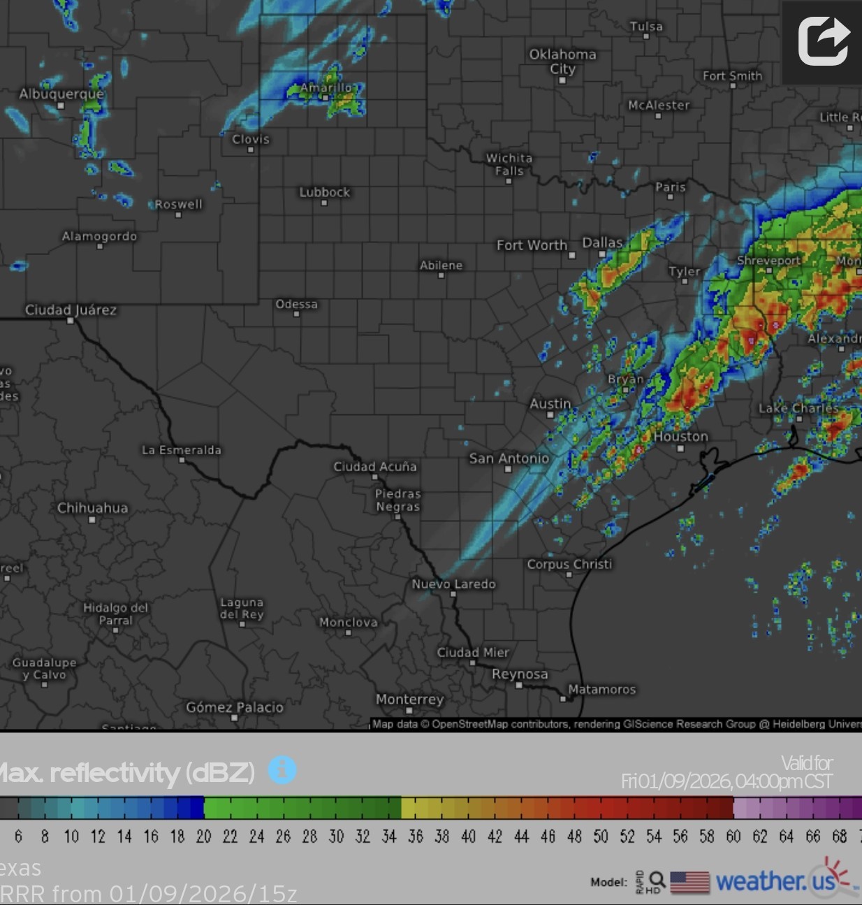
cbear reacted
|
|
StormChaser : hopefully all we get is some much needed rain and cooler weather. I don't want anything severe.
|
|
StormChaser : Thanks for the heads up! Of course one of the threats is at the time the kids get out of school. Lol
Looks like Kingwood will be right on the edge for getting the nasty stuff.
cbear and StormChaser reacted
StormChaser : Thanks for keeping us updated. Weather is ever changing.
|
|
11:10AM Scattered storms are starting to form in the area. Individual cells are moving south ➡️ north. So far, nothing severe. 👍 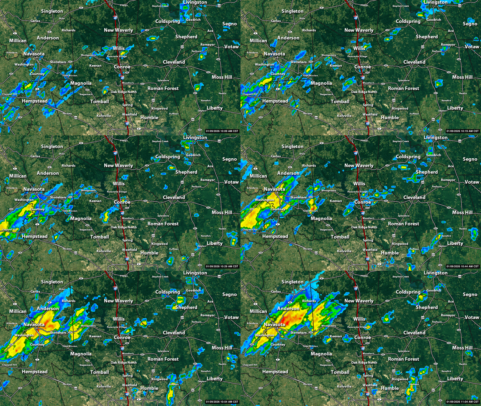
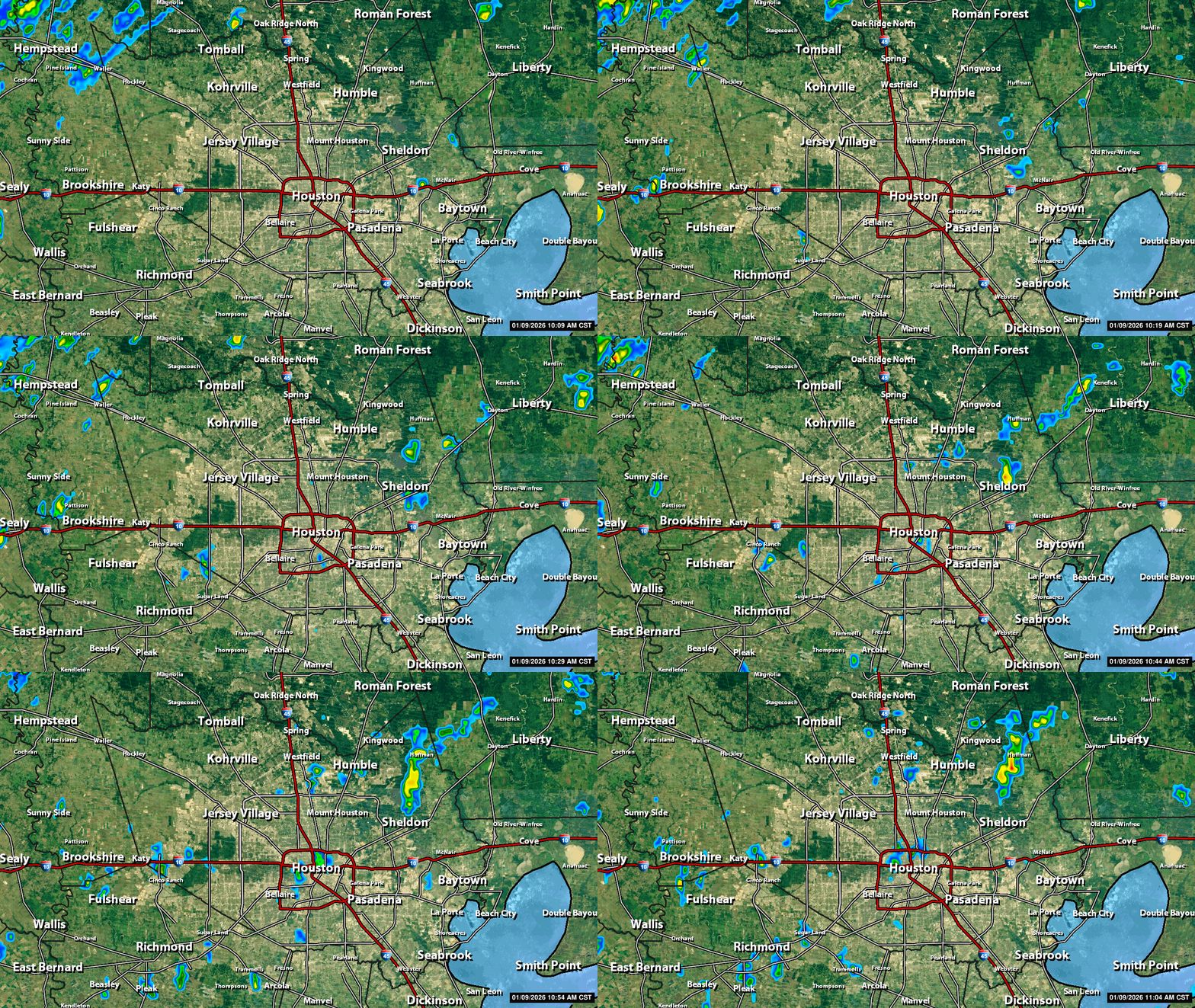 sebastian2 : Not necessarily bad but it does increase our chances of stronger cells forming this afternoon. The storms late this evening should not be severe. They'll be kinda scattered with the line so not everyone will see rain tonight.
peppermintstick reacted StormChaser : As I type the sun is coming out. Bad news?
sebastian2 : Not necessarily bad but it does increase our chances of stronger cells forming this afternoon.
|
|
 StormChaser: Thanks for keeping us updated. I'm hoping for some rain without the severe level. Looking forward to cooler.
|
|
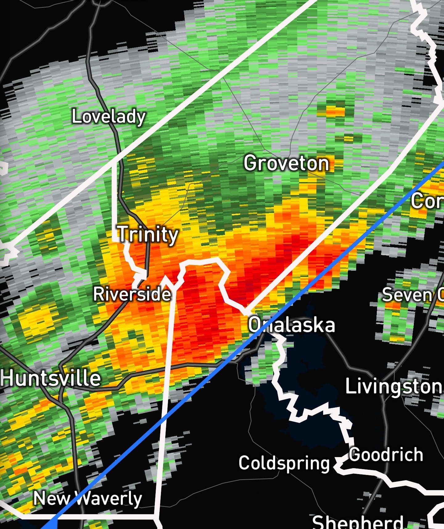
1220 The sun is out and the radar is becoming more active. That single cell to our north (that's been riding the other side of the front) has stayed just below severe limits but I don't think that trend will continue. (That cell is moving away from us) Again, north and east of here has the greatest severe threat but we could certainly see some bumpy weather this afternoon 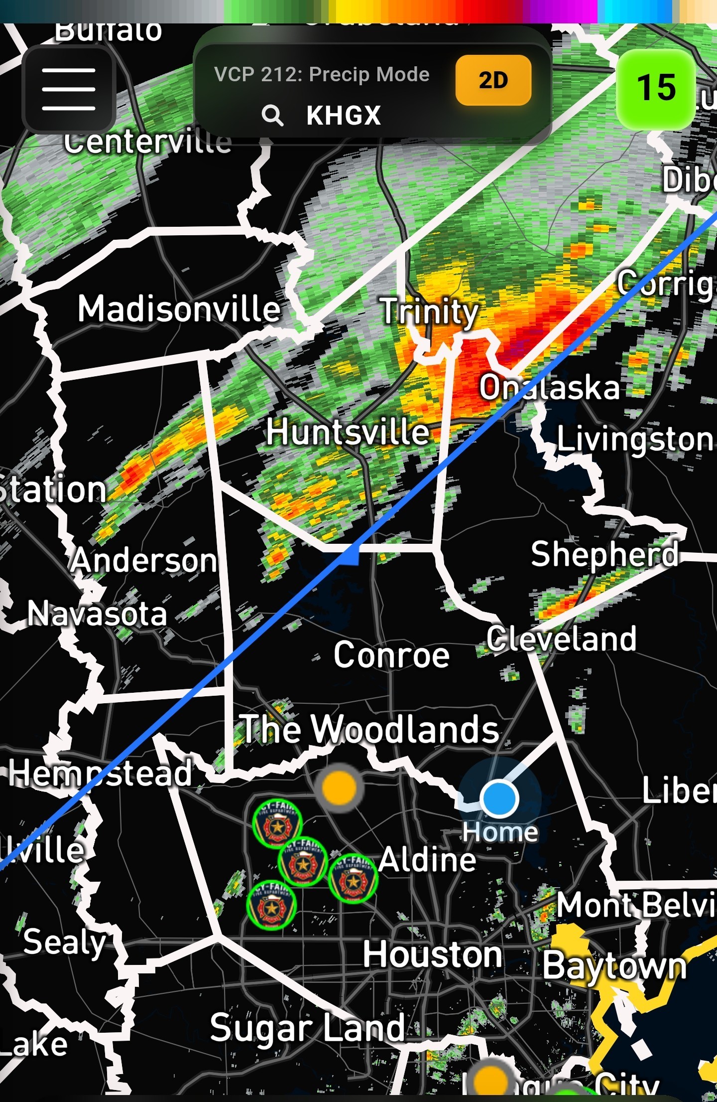
peppermintstick, Babieborris and sellbuy reacted
|
|
StormChaser : Bring it on! I'm hoping it'll cause me to go into labor. 🤣
Babieborris : « Back to Chat
Views: 725
# Replies: 28