


Arctic blast (Thurs update Pg 4)
Arctic blast (Thurs update Pg 4)


Joined:
X days ago
# Posts:
X,XXX
Contributor Points:
X


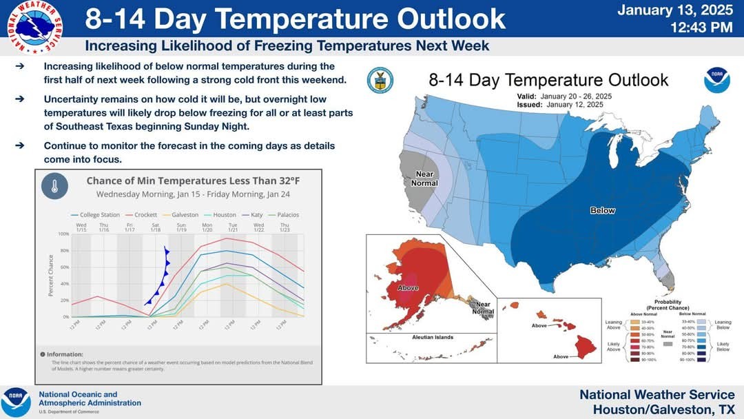
Arctic blast next week ❄️ ❄️❄️❄️❄️❄️❄️ Thursday update on Page 4! ......... The forecast for early next week looks interesting with another arctic blast with a possibility of winter precipitation. ❄️ At this point, the upcoming period of colder weather looks like it could be sharper than the first one in early January, with a hard freeze possible for much of the Houston metro area. ❄️❄️❄️❄️ 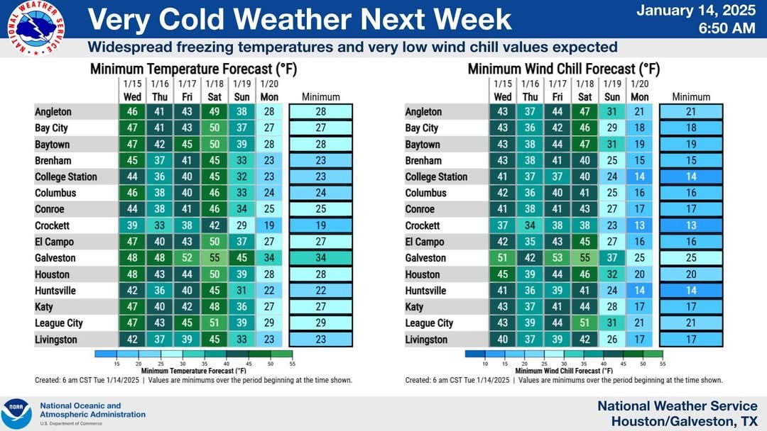 ❄️ The cold front is on schedule to arrive on Saturday, perhaps sometime around the middle of the day.
❄️ We'll be reasonably warm ahead of the front, and it looks like colder air will lag a bit behind the frontal passage.
❄️ So with partly to mostly sunny skies, we could see some highs in the upper 60s. However as evening rolls around the northerly winds will start to really ramp up, ushering in colder and drier air.
❄️ Look for overnight lows to fall to around 40 degrees in Houston, or a bit lower. 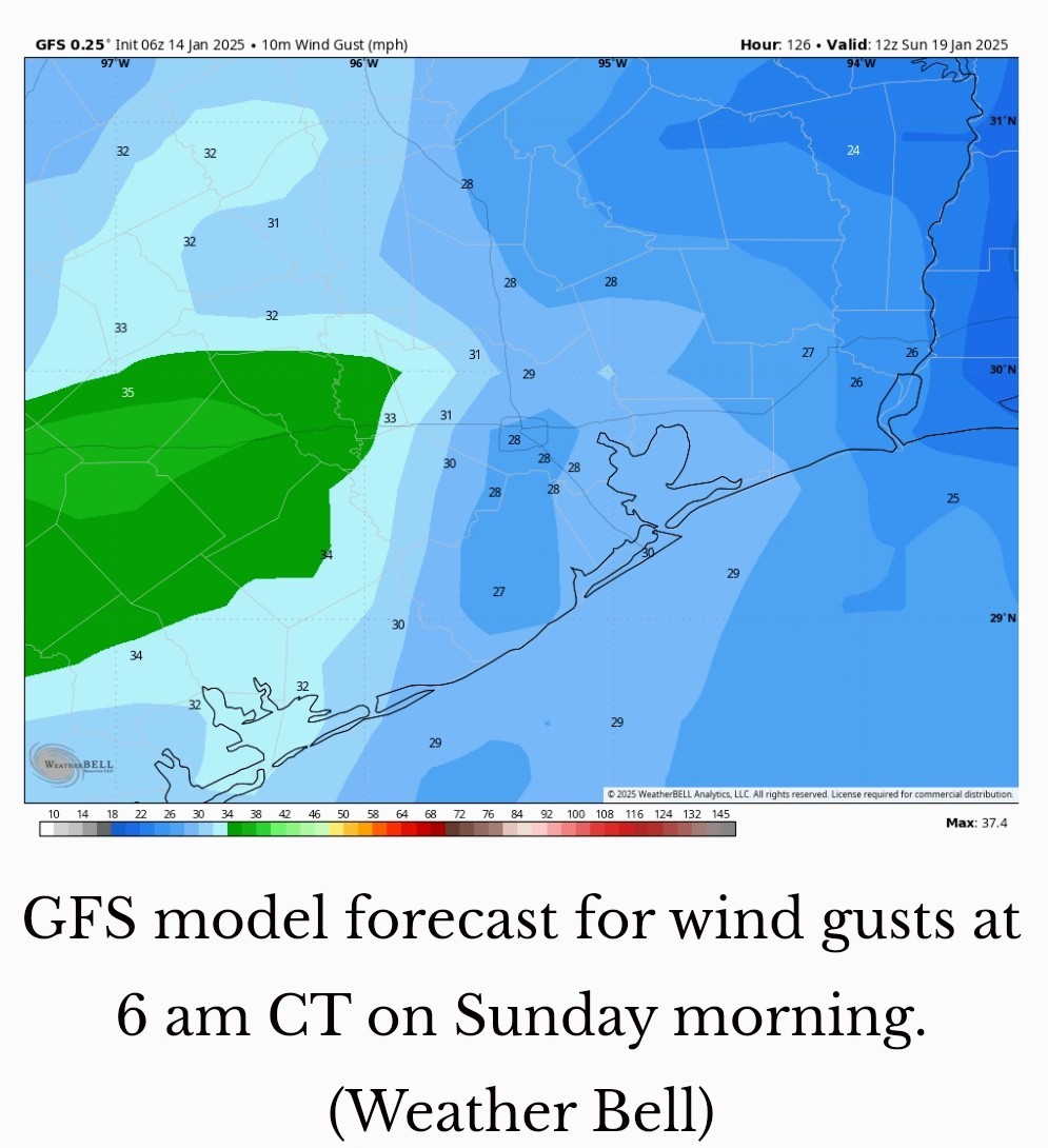 SUNDAY ❄️ If you're going to be on the start line of the Houston Marathon on Sunday morning like me, you're going to want to prepare for colder temperatures.
❄️ The good news is that I don't expect any precipitation, and skies most likely will be partly to mostly sunny. The bad news is that winds will bring an additional chill into the air.
❄️ I expect sunrise temperatures to be in the upper 30s in downtown Houston, with the likelihood of wind gusts of 20 to 30 mph, so it will feel really cold - especially in downtown with the tunneling effect between buildings.
❄️ Even for people who like to run in cold weather, like me, this is pretty chilly. ❄️ Highs will reach about 50 degrees later on Sunday before temperatures plunge on Sunday night. NEXT WEEK ❄️ So how cold will things get next week? We just cannot say for certain yet. ❄️ I think we are probably looking at lows in metro Houston anywhere from the low-20s at the low end, to low-30s at the higher end of the forecast.
❄️ The coldest days look to be Monday, Tuesday, and Wednesday before temperatures moderate toward the end of the week. 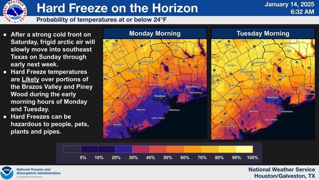
 ❄️ As for precipitation, there's a non-zero chance of snow or sleet on Monday, Monday night, or Tuesday.
❄️ I do think snow is at least a possibility, because the atmosphere looks to be freezing all the way down to the ground but it will depend on whether we get any precipitation, how much, and at what hours of the day or night. 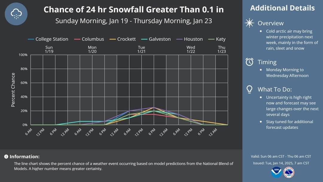 ❄️ I think the bottom line is that we might expect the possibility of some travel disruptions on Monday or Tuesday of next week, but that does not mean serious issues are likely. ❄️ We're just going to have to see how the forecast plays out over the next couple of days.





❄️ We'll be reasonably warm ahead of the front, and it looks like colder air will lag a bit behind the frontal passage.
❄️ So with partly to mostly sunny skies, we could see some highs in the upper 60s. However as evening rolls around the northerly winds will start to really ramp up, ushering in colder and drier air.
❄️ Look for overnight lows to fall to around 40 degrees in Houston, or a bit lower.
❄️ The good news is that I don't expect any precipitation, and skies most likely will be partly to mostly sunny. The bad news is that winds will bring an additional chill into the air.
❄️ I expect sunrise temperatures to be in the upper 30s in downtown Houston, with the likelihood of wind gusts of 20 to 30 mph, so it will feel really cold - especially in downtown with the tunneling effect between buildings.
❄️ Even for people who like to run in cold weather, like me, this is pretty chilly. ❄️ Highs will reach about 50 degrees later on Sunday before temperatures plunge on Sunday night.
❄️ The coldest days look to be Monday, Tuesday, and Wednesday before temperatures moderate toward the end of the week.
❄️ I do think snow is at least a possibility, because the atmosphere looks to be freezing all the way down to the ground but it will depend on whether we get any precipitation, how much, and at what hours of the day or night.
Discussion Summary:
"Upcoming Arctic Blast: Cold Temperatures and Possible Winter Precipitation in Houston Next Week"
"Upcoming Arctic Blast: Cold Temperatures and Possible Winter Precipitation in Houston Next Week"
Discussion Insights:
Ask a question about this discussion and an AI bot will try to give an answer.
Ask a question about this discussion and an AI bot will try to give an answer.
Replies:

|
 StormChaser :
 Thanks for the forecast. Yikes! I love how even they don't like to use the S word. As in... "another arctic blast with a possibility of winter precipitation." :lol"
|
|
Looking perfect for Marathon Day Sunday, cold dry and sunny, I couldnt ask for a better forecast. I just hope it doesnt change.
ZMAN : Really? He painted a pretty negative picture of the cold for the marathon. But if that works for you, then great!! Run, Z, Run!
|
|
SandyKnee : He must not be a runner then. 40 degrees feels amazing
ZMAN : Well he did mention he'd be on the starting line....
|
|
SandyKnee : He must not be a runner then. 40 degrees feels amazing
ZMAN : You need to find him on Sunday and tell him he's a wuss.  Then just make sure you outrun him.
ZMAN : Well he did mention he'd be on the starting line....
SandyKnee : It's a good forecast for running. The only cold parts will be waiting in the starting corral, and then turning north on Post Oak by the Galleria.
|
|
Arctic blast next week ❄️ The forecast for early next week looks interesting with another arctic blast with a possibility of winter precipitation. ❄️ At this point, the upcoming period of colder weather looks like it could be sharper than the first one in early January, with a hard freeze possible for much of the Houston metro area. ❄️❄️❄️❄️ ❄️ The cold front is on schedule to arrive on Saturday, perhaps sometime around the middle of the day. ❄️ We'll be reasonably warm ahead of the front, and it looks like colder air will lag a bit behind the frontal passage. ❄️ So with partly to mostly sunny skies, we could see some highs in the upper 60s. However as evening rolls around the northerly winds will start to really ramp up, ushering in colder and drier air. ❄️ Look for overnight lows to fall to around 40 degrees in Houston, or a bit lower. SUNDAY ❄️ If you're going to be on the start line of the Houston Marathon on Sunday morning like me, you're going to want to prepare for colder temperatures. ❄️ The good news is that I don't expect any precipitation, and skies most likely will be partly to mostly sunny. The bad news is that winds will bring an additional chill into the air. ❄️ I expect sunrise temperatures to be in the upper 30s in downtown Houston, with the likelihood of wind gusts of 20 to 30 mph, so it will feel really cold - especially in downtown with the tunneling effect between buildings. ❄️ Even for people who like to run in cold weather, like me, this is pretty chilly. ❄️ Highs will reach about 50 degrees later on Sunday before temperatures plunge on Sunday night. NEXT WEEK ❄️ So how cold will things get next week? We just cannot say for certain yet. ❄️ I think we are probably looking at lows in metro Houston anywhere from the low-20s at the low end, to low-30s at the higher end of the forecast. ❄️ The coldest days look to be Monday, Tuesday, and Wednesday before temperatures moderate toward the end of the week. ❄️ As for precipitation, there's a non-zero chance of snow or sleet on Monday, Monday night, or Tuesday. ❄️ I do think snow is at least a possibility, because the atmosphere looks to be freezing all the way down to the ground but it will depend on whether we get any precipitation, how much, and at what hours of the day or night. ❄️ I think the bottom line is that we might expect the possibility of some travel disruptions on Monday or Tuesday of next week, but that does not mean serious issues are likely. ❄️ We're just going to have to see how the forecast plays out over the next couple of days.
StormChaser :
Looking perfect for Marathon Day Sunday, cold dry and sunny, I couldnt ask for a better forecast. I just hope it doesnt change.
ZMAN : This is a good forecast for sure. It is similar to last year. Wear a throw-away hoodie or sweater that you can ditch at the start. 
buffaloglenn : Will you be running this year as well?
SandyKnee : Yep - my training has been sub-par as I missed all of September running because of an injured knee. My goal this year is to finish.
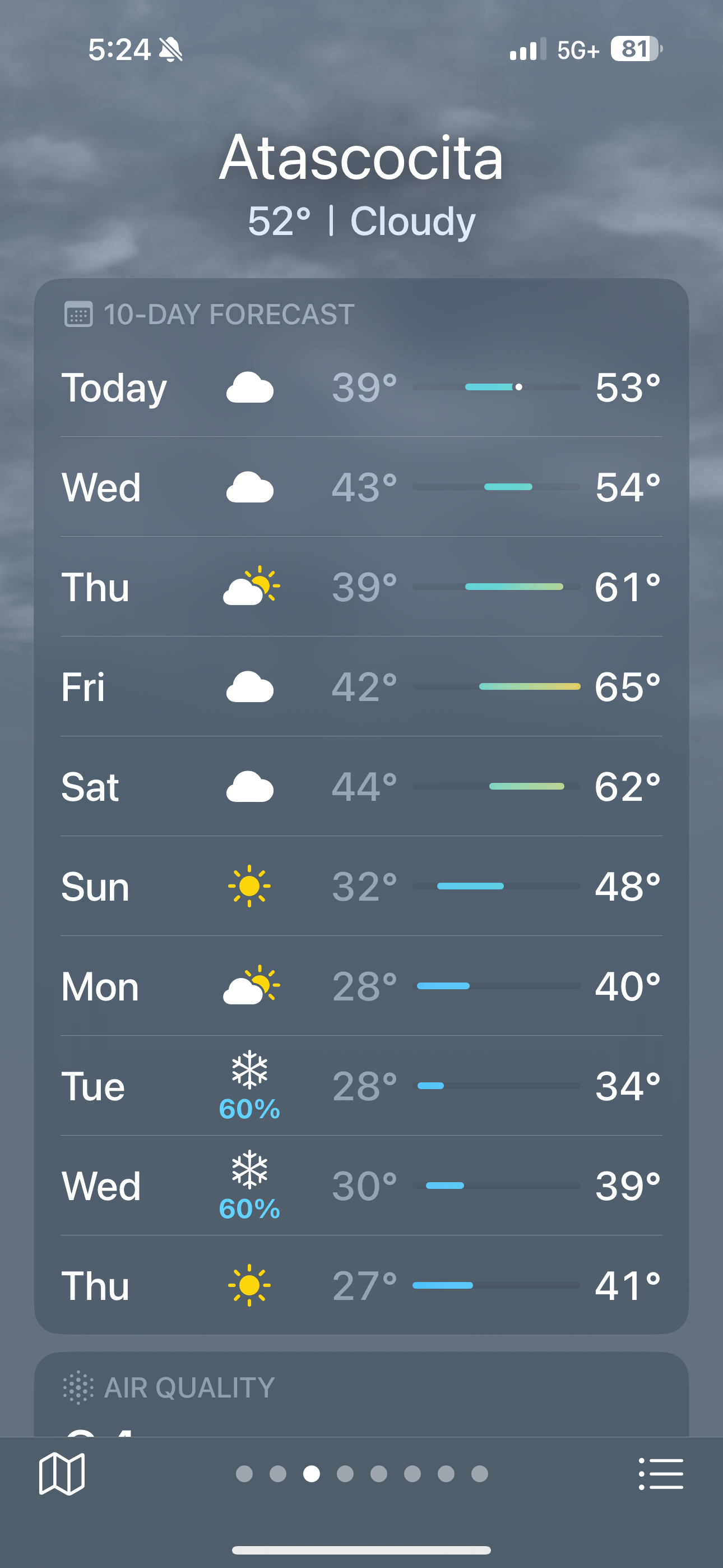
Edit to say Tuesday and Wednesday.
|
|
StormChaser : Thank you for all of this helpful information. I am not looking forward to any of it at all. Good Luck to all of the people here that are running in Sunday's marathon!
« Back to Chat
Views: 3,723
# Replies: 57