


Tropics update invest 92L
Tropics update invest 92L


Joined:
X days ago
# Posts:
X,XXX
Contributor Points:
X


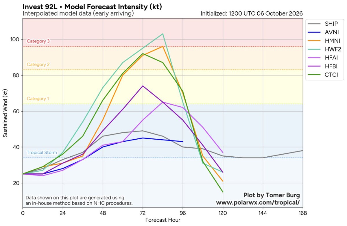
Tropics update invest 92L ❗️Impacts on Texas are slim to none ❗️ The Gulf disturbance just went from 80% to 90%, and it could be a tropical depression by tomorrow. 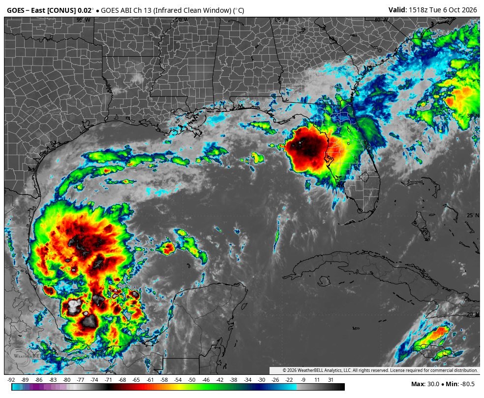 Most of the models are now suggesting the system will be at cat 1 hurricane (the first of 2026) strength by the time it reaches the central Gulf Coast on Saturday.
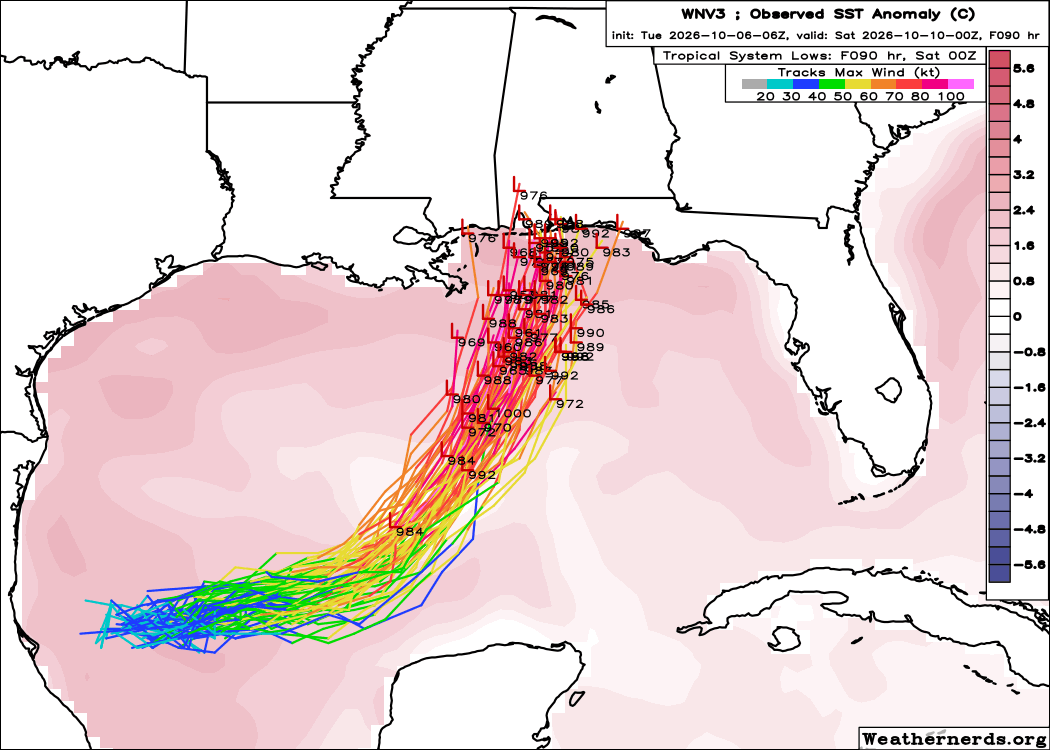
  👉 The name of this storm will be Isaias. (ees-ah-EE-ahs) 1. A tropical depression is likely to form over the next day or so over the southwestern Gulf with further strengthening expected later this week when it turns northward. 2. This system could bring gusty winds and areas of heavy rain to the western portion of the Yucatan Peninsula in a couple of days. 3. It is still too soon to specify the exact location and magnitude of wind and storm surge impacts along the northern Gulf Coast, but interests from the Florida Panhandle to Louisiana should closely monitor the progress of this system. 4. Regardless of development, heavy rainfall and associated flooding impacts could occur over portions of the northern Gulf Coast, the southeastern United States, and Florida later this week and this weekend. The latest track forecast from the Google Deep Mind model, which performed very well last year.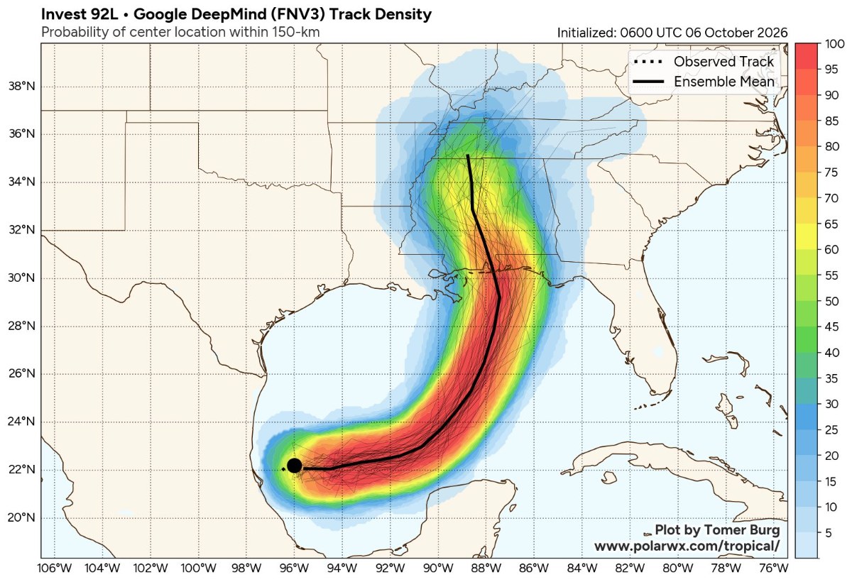


BELIEVE, Aggie89 and wmubronco + 10 more reacted Replies:
 StormChaser :
 Thanks for updating us. You are the best. We could use some rain but thankfully no storm is coming here.

|
#msg6024046Tropics update invest 92L ❗️Impacts on Texas are slim to none ❗️ The Gulf disturbance just went from 80% to 90%, and it could be a tropical depression by tomorrow. Most of the models are now suggesting the system will be at cat 1 hurricane (the first of 2026) strength by the time it reaches the central Gulf Coast on Saturday. 👉 The name of this storm will be Isaias. (ees-ah-EE-ahs) 1. A tropical depression is likely to form over the next day or so over the southwestern Gulf with further strengthening expected later this week when it turns northward. 2. This system could bring gusty winds and areas of heavy rain to the western portion of the Yucatan Peninsula in a couple of days. 3. It is still too soon to specify the exact location and magnitude of wind and storm surge impacts along the northern Gulf Coast, but interests from the Florida Panhandle to Louisiana should closely monitor the progress of this system. 4. Regardless of development, heavy rainfall and associated flooding impacts could occur over portions of the northern Gulf Coast, the southeastern United States, and Florida later this week and this weekend. The latest track forecast from the Google Deep Mind model, which performed very well last year.
StormChaser : I just want a little rain!
#msg6024081StormChaser : I just want a little rain!
TEXASGIRLMAMMA : i wouldn't mind A LOT of rain! we just laid sod
Three inches of slow and steady rain would certainly be nice. thanks for all the great info!
Jeepinbear, Donnawisdom and peppermintstick + 2 more reacted 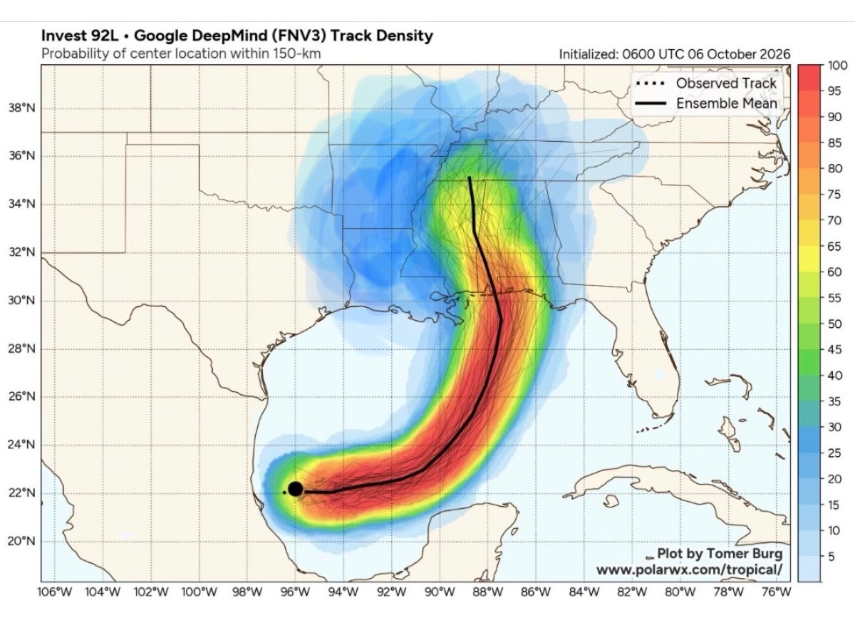
I hope they are right about the path. Just a couple of. Nights ago, no development expected for two days, wind shear would keep it to a tropical depression etc, etc.
|
|
#msg6024087TEXASGIRLMAMMA : i wouldn't mind A LOT of rain! we just laid sod
Ruger5 : Rain would be good!
|
|
Forecast is now for a category 2 hurricane to make landfall near Mobile AL on Friday afternoon! Nola to Panama City needs to prepare. Never ignore a storm in the Gulf! 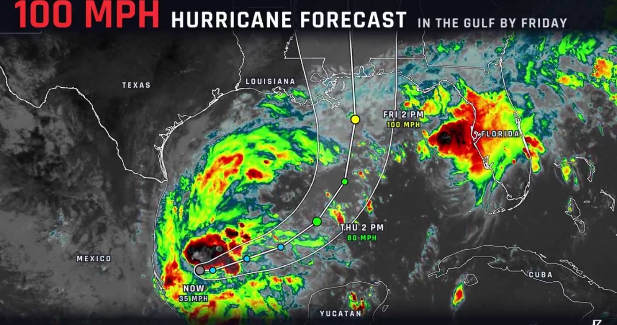
mutton reacted
|
|
Ruger5 : 
« Back to Chat
Views: 421
# Replies: 18