


Sun AM weather update
Sun AM weather update


Joined:
X days ago
# Posts:
X,XXX
Contributor Points:
X


Sun AM weather update Current temp: 33.5° @ 7am. Alright guys - We have some light rain/freezing rain/sleet at the moment but the precipitation is almost out of here. 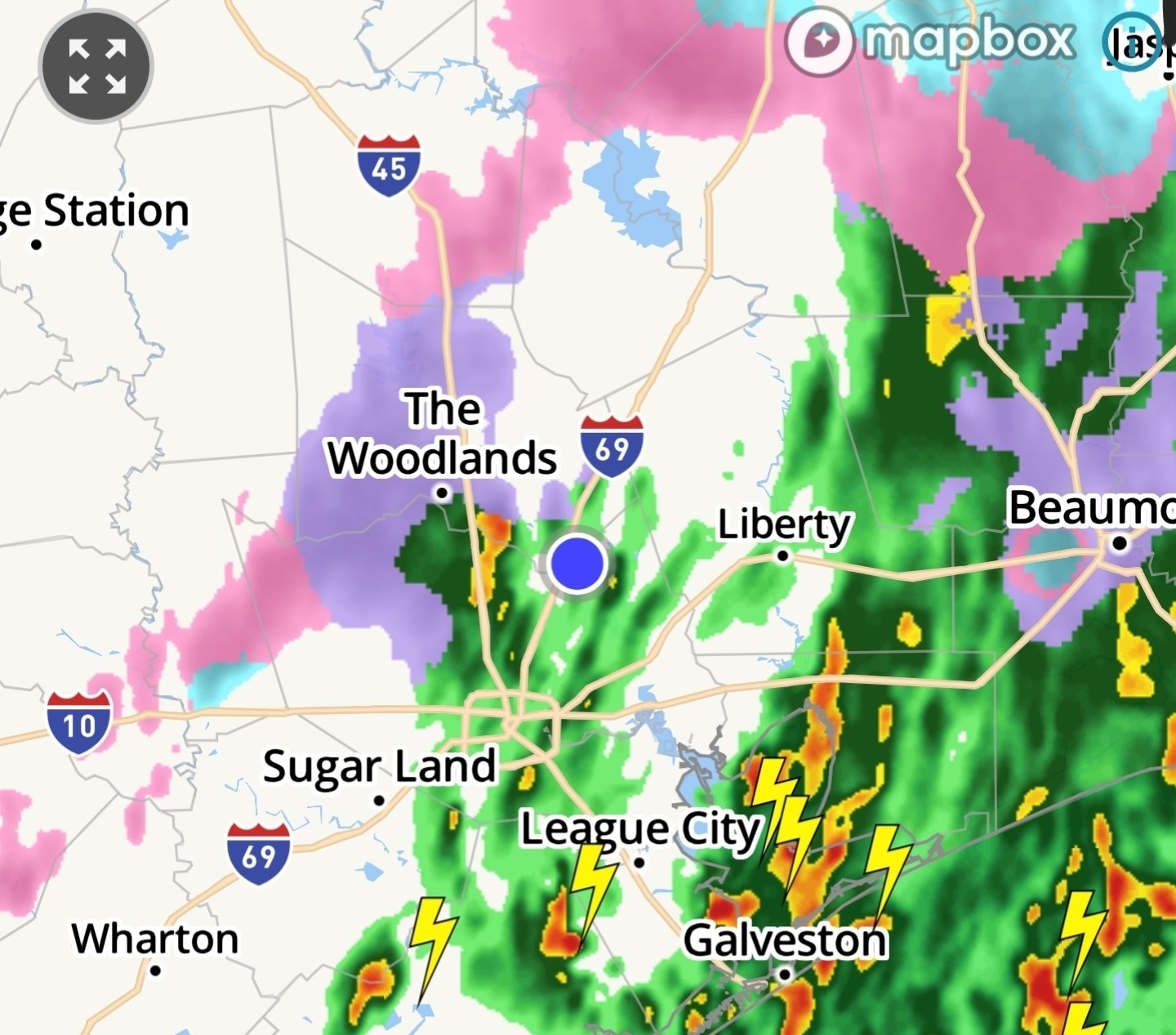
Looks like temps will stay right at 30°-31° for the day.
Bridges and overpasses will likely have issues but our trees and powerlines should be fine. 👍
If you go just north & west of us, you will have bigger issues, as they saw a lot of freezing rain. (Cypress ares ➡️ westward)
All in all - we got lucky. The heavier rain we got this AM warmed the surface air 2° - to 33.5° - due to warmer air aloft being brought to the surface. That kept our precip as rain, not freezing rain, which prevented a pretty hefty ice storm. We do have strong winds to deal with today of 30+ mph. And that could cause some power issues. Hopefully not, but just be aware. We'll have a hard freeze tonight - and whatever is left on the roadways will freeze - but the winds today will help dry things out. Its still unknown though what issues we'll have tomorrow. ........ From Space City Weather: A mix of rain, freezing rain, sleet, and even a few pockets of snow are falling across Houston. Eric Berger · Sunday, January 25, 2026 6:44 AM In brief: *As we have been forecasting for days now about Sunday, it is a very close call out there for freezing precipitation in Houston this morning.
*Temperatures are falling to just about to the freezing level as a line of showers moves through, and accordingly we are seeing everything at the moment: rain, freezing rain, sleet, eve a little snow. Impacts are to be determined. Winter storm status - *Houston is now receiving its second, and final round of precipitation with this winter event.
*The precipitation is continuing as temperatures fall to around the freezing level in the city, and it is leading to varying levels of impacts on roadways.
*Fortunately, much of the precipitation this morning has fallen as rainfall or sleet, and this has spared us from power-line impacts due to ice accumulations. As of 6 am CT only a few thousand CenterPoint customers are without power. *We strongly urge caution with using area roadways this morning.
*Some areas north and west of Houston are ice bound, and there are reports of ice on several Houston area freeways.
*I would treat all overpasses and ramps as suspect as well, with the potential for icy patches.
*However, with air temperatures still in the 31 to 34 degree range, roads in the city are not freezing quickly. Many are still wet rather than icy. Sunday forecast - *The showers (and a few thunderstorms) should exit the region to our east by around 8 am. And that will likely be the end of the precipitation.
*After this, we are going to see gusty winds from the north, perhaps as high as 30 mph this afternoon as Arctic air surges into the region.
*We may also see some sporadic sunshine.
*Temperatures today are unlikely to rise much above freezing.
*Areas along and south of Highway 59/Interstate 69 may reach the mid-30s for a few hours this afternoon, but areas such as Katy, Cypress, and Kingwood may max out at about 30 degrees this afternoon. *All of this raises difficult to answer questions about the state of roads later today.
*On one hand, the precipitation ends, and strong winds will have a drying effect on roads.
*However, the colder temperatures this afternoon, especially for inland areas, will lock any ice into place.
*We will know more in a few hours, but at this point my expectation is for icy patches on roadways, with issues on bridges and overpasses.
*However, we are now unlikely to see a widespread ice storm, which should be favorable for impacts later today and on Monday morning.
*Let's see what happens over the next few hours. *Again, if you can stay home this morning it is highly advisable, because as temperatures fall this morning water on roads can freeze. *With mostly cloudy skies we should see low temperatures tonight drop into the 20 to 25 degree range in Houston.
*Ongoing northerly winds at 15 mph, with higher gusts, will add additional chill to the air.
*Please protect pets from this very cold weather tonight. Monday - *We should see clearing skies on Monday, but temperatures will be slow to warm with the ongoing advection of cold air into the region.
*By around noon, or shortly after, we should see temperatures rise above freezing for a few hours, reaching 35 to possibly 40 degrees for much of the region.
*Lows on Monday night will be similar to Sunday night, still very cold, but with clear skies and lighter winds.


peppermintstick, 4Mom and ForestFinds + 5 more reacted Looks like temps will stay right at 30°-31° for the day.
Bridges and overpasses will likely have issues but our trees and powerlines should be fine. 👍
If you go just north & west of us, you will have bigger issues, as they saw a lot of freezing rain. (Cypress ares ➡️ westward)
All in all - we got lucky. The heavier rain we got this AM warmed the surface air 2° - to 33.5° - due to warmer air aloft being brought to the surface. That kept our precip as rain, not freezing rain, which prevented a pretty hefty ice storm.
*Temperatures are falling to just about to the freezing level as a line of showers moves through, and accordingly we are seeing everything at the moment: rain, freezing rain, sleet, eve a little snow. Impacts are to be determined.
*The precipitation is continuing as temperatures fall to around the freezing level in the city, and it is leading to varying levels of impacts on roadways.
*Fortunately, much of the precipitation this morning has fallen as rainfall or sleet, and this has spared us from power-line impacts due to ice accumulations.
*Some areas north and west of Houston are ice bound, and there are reports of ice on several Houston area freeways.
*I would treat all overpasses and ramps as suspect as well, with the potential for icy patches.
*However, with air temperatures still in the 31 to 34 degree range, roads in the city are not freezing quickly.
*After this, we are going to see gusty winds from the north, perhaps as high as 30 mph this afternoon as Arctic air surges into the region.
*We may also see some sporadic sunshine.
*Temperatures today are unlikely to rise much above freezing.
*Areas along and south of Highway 59/Interstate 69 may reach the mid-30s for a few hours this afternoon, but areas such as Katy, Cypress, and Kingwood may max out at about 30 degrees this afternoon.
*On one hand, the precipitation ends, and strong winds will have a drying effect on roads.
*However, the colder temperatures this afternoon, especially for inland areas, will lock any ice into place.
*We will know more in a few hours, but at this point my expectation is for icy patches on roadways, with issues on bridges and overpasses.
*However, we are now unlikely to see a widespread ice storm, which should be favorable for impacts later today and on Monday morning.
*Let's see what happens over the next few hours.
*Ongoing northerly winds at 15 mph, with higher gusts, will add additional chill to the air.
*Please protect pets from this very cold weather tonight.
*By around noon, or shortly after, we should see temperatures rise above freezing for a few hours, reaching 35 to possibly 40 degrees for much of the region.
*Lows on Monday night will be similar to Sunday night, still very cold, but with clear skies and lighter winds.
Replies:
It just started raining harder here. Maybe freezing rain.
Wingsofwonder, Txbutterfly and StormChaser reacted

|
Jeff Lindner 1-25-26 700am Freezing rain and sleet reported over portions of the area overnight
Hard freezes remain likely tonight and Monday night
Dangerously cold wind chills Monday AM
Any remaining water will freeze tonight even on ground surfaces
Freezing line has been slow to move southeastward overnight and currently extends from Cleveland to The Woodlands to Waller to Bay City or wrapping around the metro area on the west side. Overnight rainfall has helped bring down some warmer air from aloft and the surface temperatures actually increased 1-2 degrees during the heavier rainfall. High resolution guidance continues to insist that the very cold air just to the NW of the metro area will surge into the area over the next few hours (it is 21 in College Station so there is some very cold air just to the northwest). Precipitation will be ending in the next few hours and the question is does the precipitation end before the stronger push of colder air moves into the metro area. If the high resolution guidance is correct a quick icing of bridges and overpasses on the north and west sides of the metro area remains a possibility through mid morning. For the City of Houston and areas to the southeast it looks like the temperatures will be just a degree or two warm enough to keep any icing of bridges and overpasses to a minimum but will have to watch trends closely.
Temperatures:
With temperatures a few degrees warmer this morning it is possible that parts of the area either stay or rise above freezing later today for a few hours. Very cold conditions tonight, but overnight lows have been raised a few degrees with lingering clouds. Monday night and Tuesday morning look to be the coldest morning with clear skies and light winds.
These are dangerously cold temperatures that can result in damage to infrastructure
Additionally, wind chills on Monday morning will be in the upper 1's and low 10's over the region.
North of HWY 105:
Mon AM: 18-20
Tues AM: 12-16
North of I-10
Mon AM: 22-24
Tues AM: 15-22
South of I-10:
Mon AM: 22-25
Tues AM: 17-21 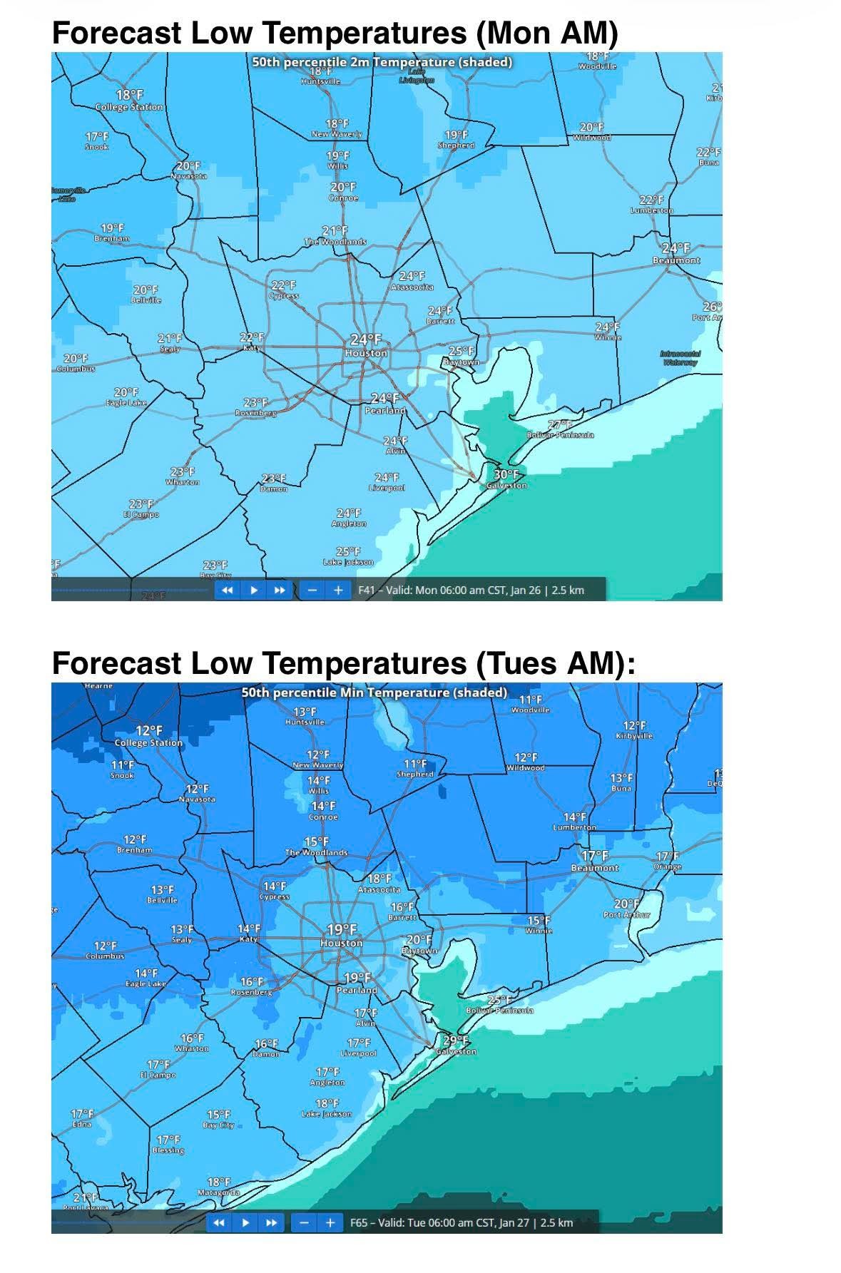
4Mom, HappyinTX and Texasdaughter + 1 more reacted Hard freezes remain likely tonight and Monday night
Dangerously cold wind chills Monday AM
Any remaining water will freeze tonight even on ground surfaces
Freezing line has been slow to move southeastward overnight and currently extends from Cleveland to The Woodlands to Waller to Bay City or wrapping around the metro area on the west side.
Temperatures:
With temperatures a few degrees warmer this morning it is possible that parts of the area either stay or rise above freezing later today for a few hours. Very cold conditions tonight, but overnight lows have been raised a few degrees with lingering clouds. Monday night and Tuesday morning look to be the coldest morning with clear skies and light winds.
These are dangerously cold temperatures that can result in damage to infrastructure
Additionally, wind chills on Monday morning will be in the upper 1's and low 10's over the region.
North of HWY 105:
Mon AM: 18-20
Tues AM: 12-16
North of I-10
Mon AM: 22-24
Tues AM: 15-22
South of I-10:
Mon AM: 22-25
Tues AM: 17-21
|
|
Temperatures are quickly falling the western part of Harris County. Waller fell from 31 to 28 in 20 min and Katy has fallen from 31 to 27 in 30 min. 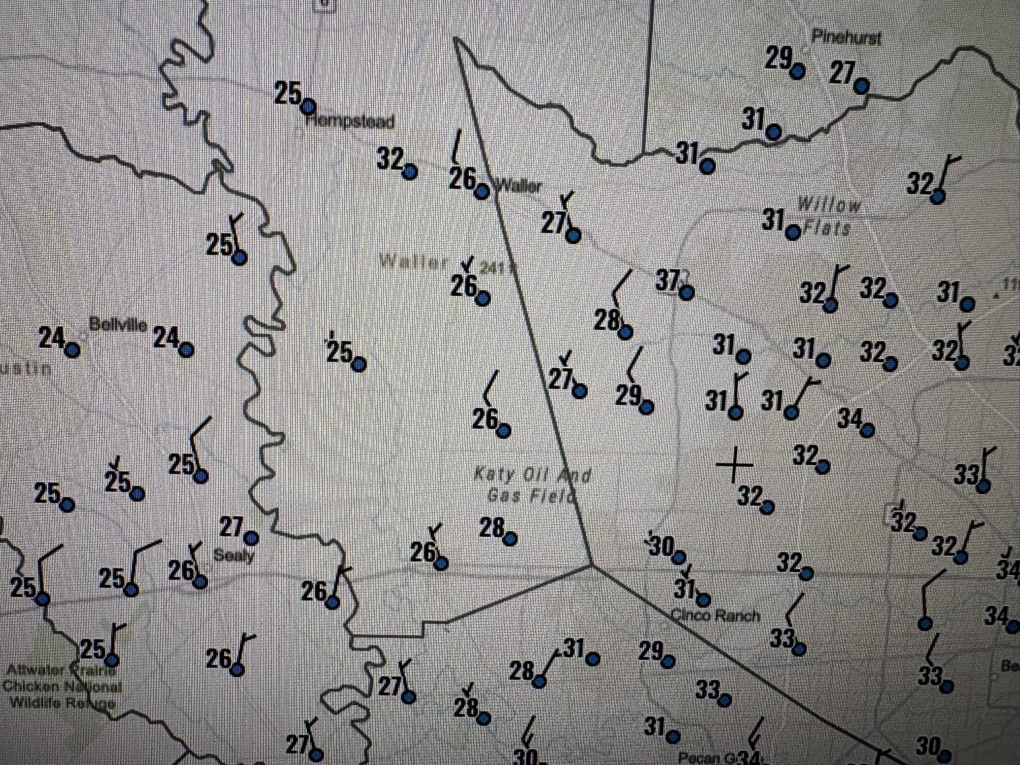 Our temps will be doing the same soon.....just as the moisture moves out.
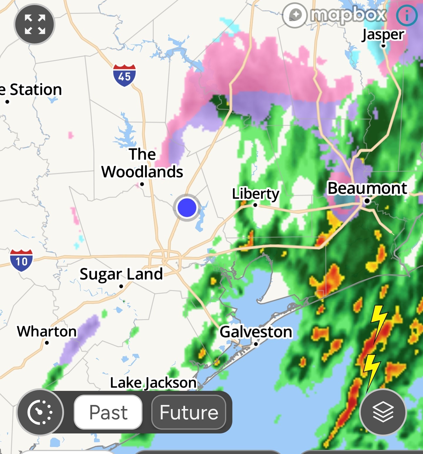 I wanted to play in the ice ******! 😭🧊
4Mom, bigla and Wingsofwonder reacted
|
|

Sun AM weather update Current temp: 33.5° 7am. Alright guys - We have some light rain/freezing rain/sleet at the moment but the precipitation is almost out of here. Looks like temps will stay right at 30°-31° for the day. Bridges and overpasses will likely have issues but our trees and powerlines should be fine. 👍 If you go just north & west of us, you will have bigger issues, as they saw a lot of freezing rain. (Cypress ares ➡️ westward) All in all - we got lucky. The heavier rain we got this AM warmed the surface air 2° - to 33.5° - due to warmer air aloft being brought to the surface. That kept our precip as rain, not freezing rain, which prevented a pretty hefty ice storm. We do have strong winds to deal with today of 30+ mph. And that could cause some power issues. Hopefully not, but just be aware. We'll have a hard freeze tonight - and whatever is left on the roadways will freeze - but the winds today will help dry things out. Its still unknown though what issues we'll have tomorrow. ........ From Space City Weather: A mix of rain, freezing rain, sleet, and even a few pockets of snow are falling across Houston. Eric Berger · Sunday, January 25, 2026 6:44 AM In brief: *As we have been forecasting for days now about Sunday, it is a very close call out there for freezing precipitation in Houston this morning. *Temperatures are falling to just about to the freezing level as a line of showers moves through, and accordingly we are seeing everything at the moment: rain, freezing rain, sleet, eve a little snow. Impacts are to be determined. Winter storm status - *Houston is now receiving its second, and final round of precipitation with this winter event. *The precipitation is continuing as temperatures fall to around the freezing level in the city, and it is leading to varying levels of impacts on roadways. *Fortunately, much of the precipitation this morning has fallen as rainfall or sleet, and this has spared us from power-line impacts due to ice accumulations. As of 6 am CT only a few thousand CenterPoint customers are without power. *We strongly urge caution with using area roadways this morning. *Some areas north and west of Houston are ice bound, and there are reports of ice on several Houston area freeways. *I would treat all overpasses and ramps as suspect as well, with the potential for icy patches. *However, with air temperatures still in the 31 to 34 degree range, roads in the city are not freezing quickly. Many are still wet rather than icy. Sunday forecast - *The showers (and a few thunderstorms) should exit the region to our east by around 8 am. And that will likely be the end of the precipitation. *After this, we are going to see gusty winds from the north, perhaps as high as 30 mph this afternoon as Arctic air surges into the region. *We may also see some sporadic sunshine. *Temperatures today are unlikely to rise much above freezing. *Areas along and south of Highway 59/Interstate 69 may reach the mid-30s for a few hours this afternoon, but areas such as Katy, Cypress, and Kingwood may max out at about 30 degrees this afternoon. *All of this raises difficult to answer questions about the state of roads later today. *On one hand, the precipitation ends, and strong winds will have a drying effect on roads. *However, the colder temperatures this afternoon, especially for inland areas, will lock any ice into place. *We will know more in a few hours, but at this point my expectation is for icy patches on roadways, with issues on bridges and overpasses. *However, we are now unlikely to see a widespread ice storm, which should be favorable for impacts later today and on Monday morning. *Let's see what happens over the next few hours. *Again, if you can stay home this morning it is highly advisable, because as temperatures fall this morning water on roads can freeze. *With mostly cloudy skies we should see low temperatures tonight drop into the 20 to 25 degree range in Houston. *Ongoing northerly winds at 15 mph, with higher gusts, will add additional chill to the air. *Please protect pets from this very cold weather tonight. Monday - *We should see clearing skies on Monday, but temperatures will be slow to warm with the ongoing advection of cold air into the region. *By around noon, or shortly after, we should see temperatures rise above freezing for a few hours, reaching 35 to possibly 40 degrees for much of the region. *Lows on Monday night will be similar to Sunday night, still very cold, but with clear skies and lighter winds.
StormChaser : Thankful. « Back to Chat
Views: 449
# Replies: 4