


Severe weather Monday (now includes Htown)
Severe weather Monday (now includes Htown)


Joined:
X days ago
# Posts:
X,XXX
Contributor Points:
X


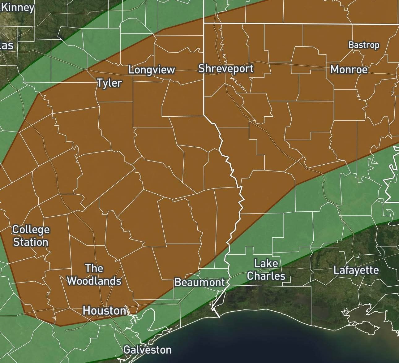
Severe weather possible Monday The severe line has moved south and now includes Houston. Info in comments below. ......... This hasn't been posted or discussed yet by Space City Weather but a statement his been issued by the SPC (Storm Predictions Center) for Monday. (Tomorrow) INCREASING SEVERE RISK: the SPC has introduced a higher severe risk on Monday. All modes of severe weather appear possible. From the SPC (Storm Prediction Center) 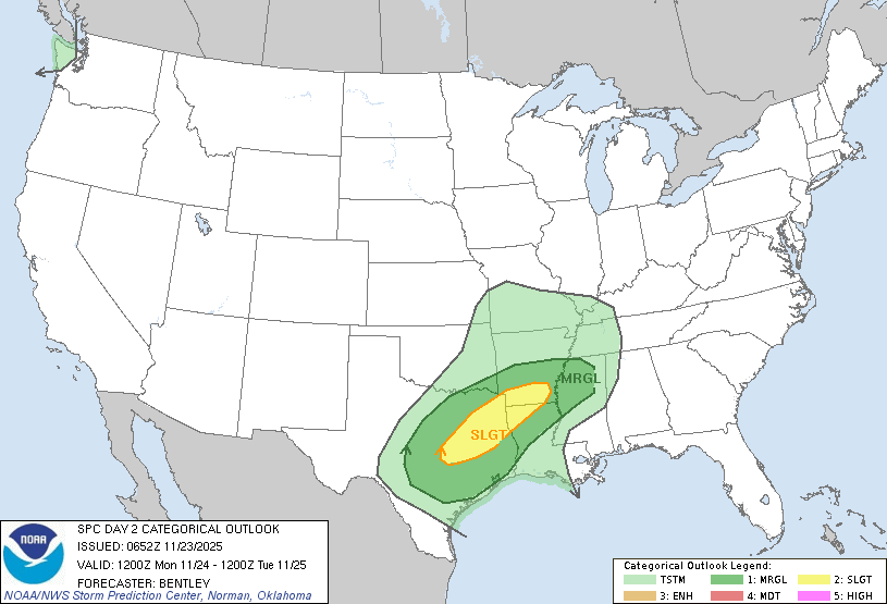 A severe weather event will unfold late Monday over Texas and Arkansas with the possibility of damaging winds, large hail, and a few tornadoes across Texas and the Deep South. Statement from the Storm Prediction Center: Day 2 Convective Outlook
NWS Storm Prediction Center Norman OK
Sun Nov 23 2025 THERE IS A SLIGHT RISK OF SEVERE THUNDERSTORMS IN EAST TEXAS TO FAR SOUTHERN ARKANSAS... SUMMARY: Scattered severe thunderstorms are possible from later Monday afternoon into Monday night across east Texas towards the Ark-La-Miss. A few tornadoes along with large hail and damaging winds are anticipated. SYNOPSIS: A mid-level shortwave trough will traverse the central/southern states on Monday with a second mid-level trough advancing from the Northwest to the northern Plains. At the surface, high pressure will dominate much of the eastern CONUS with broad low pressure across the Plains and Upper Midwest. A warm front near the Gulf Coast Monday morning will lift north through the day. East Texas to southern Arkansas: Elevated thunderstorms will be ongoing at the beginning of the period from north-central Texas to southern Arkansas to the north of a warm front. Isolated large hail is possible with these storms, but a more widespread threat is not expected during the morning. The warm front will advect northward quickly through the day and lead to moderate destabilization across the warm sector. A messy storm mode is expected along the warm front for much of the day with some marginal severe threat. The greatest severe weather threat should begin by mid-afternoon as height falls overspread the warm sector and slight mid-level cooling results in an uncapped warm sector. This should result in scattered supercell development within the open warm-sector by late afternoon. A strengthening low-level jet (40-45 knots) is expected to overspread the warm sector during this same timeframe. This may result in a brief window during the late afternoon to early evening where a few tornadoes (perhaps strong) could occur. A nocturnal wind/tornado threat may persist into the late evening/overnight period as rich low-level moisture will help to maintain an unstable boundary layer into the overnight period where cyclonically curved low-level hodographs will persist. 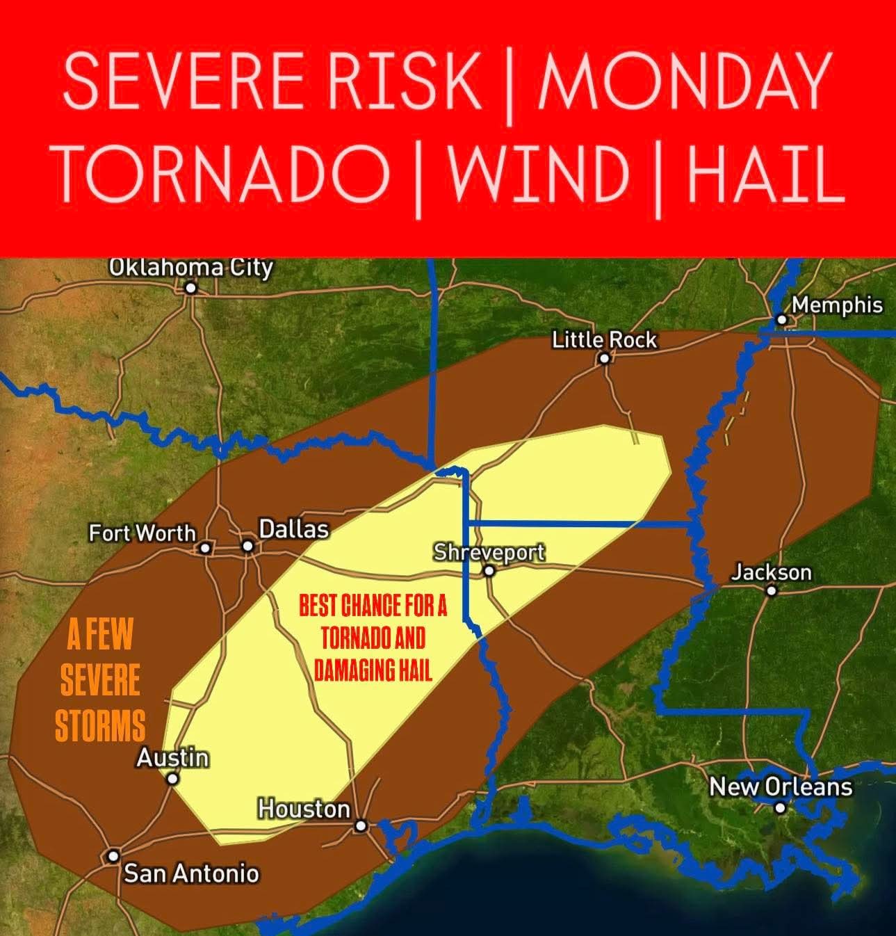


jv339, Kittle and peppermintstick + 6 more reacted NWS Storm Prediction Center Norman OK
Sun Nov 23 2025
Replies:
Space City Weather just made a post about the severe weather risk on Monday: A low-end severe weather risk for Houston on Monday. Matt Lanza · Sunday, November 23, 2025 10:03 AM In brief: There is a low-end risk for a severe storm or two on Monday evening across the area as cooler, drier air builds in. Monday - *We'll start the day off mostly cloudy with a little more humidity and scattered showers developing.
*These showers will be off & on and mostly light throughout the day.
*The much-advertised thunderstorms will arrive in the Brazos Valley and Aggieland during the late afternoon, bringing a chance of strong storms.
*That line will then slide south and east, arriving in the northwest suburbs of Houston by about early evening.
*Most activity will lift to the north from there, bringing more numerous early evening storms up into Montgomery and Walker Counties. 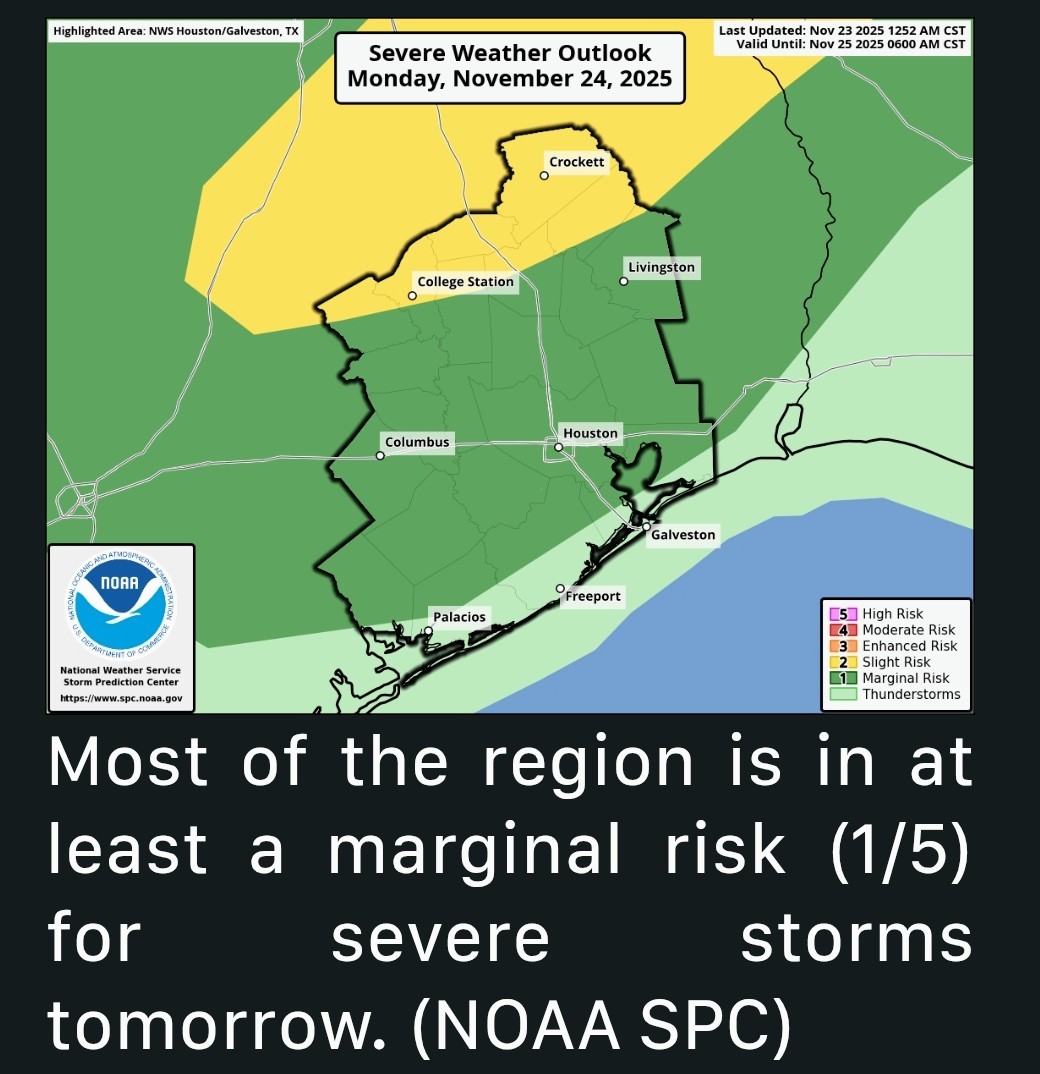 *Then, the front itself pushes into the northwest suburbs with a line of thunderstorms after 8 or 9 PM.
*That will push across the Houston area over the next few hours, arriving at the coast by about 1 to 3 AM.
*Storms will be strong with some gusty winds and lightning possible, along with heavy rain.
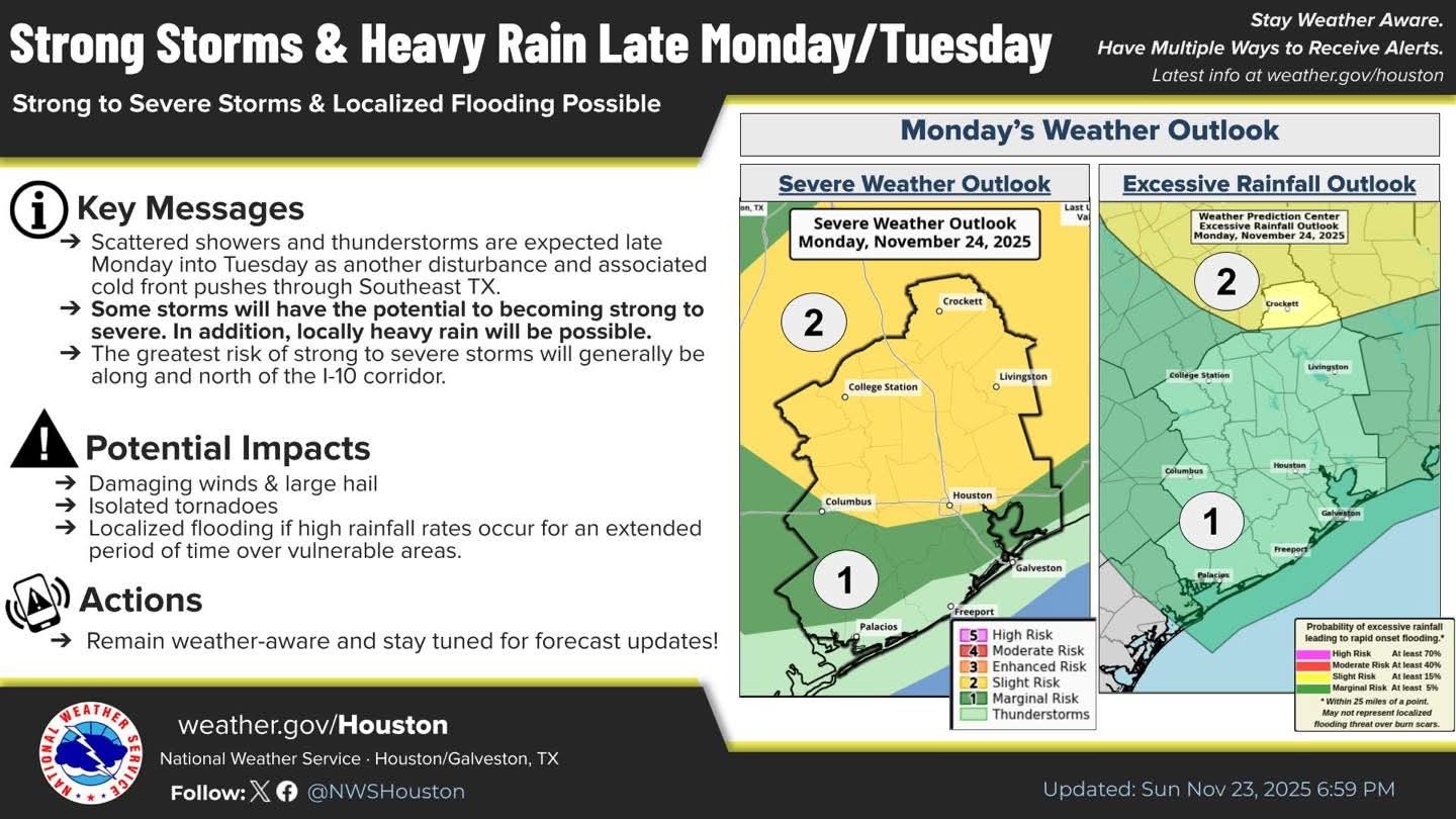
*We are outlined in a marginal risk (1 of 5) for severe weather tomorrow, with a slight risk (2/5) up toward College Station.
peppermintstick reacted *These showers will be off & on and mostly light throughout the day.
*The much-advertised thunderstorms will arrive in the Brazos Valley and Aggieland during the late afternoon, bringing a chance of strong storms.
*That line will then slide south and east, arriving in the northwest suburbs of Houston by about early evening.
*Most activity will lift to the north from there, bringing more numerous early evening storms up into Montgomery and Walker Counties.
*That will push across the Houston area over the next few hours, arriving at the coast by about 1 to 3 AM.
*Storms will be strong with some gusty winds and lightning possible, along with heavy rain.
*We are outlined in a marginal risk (1 of 5) for severe weather tomorrow, with a slight risk (2/5) up toward College Station.
StormChaser : I was going to take a senior to an appointment but it was cancelled. I was not happy because it is my only day off, but looks like I don't want to be driving in rough weather north of here.
Will be looking for your updates on this weather situation; sounds like we might see some rough weather.
peppermintstick, teatime and jv339 + 2 more reacted
StormChaser :
StormChaser : I just hope we get some much needed rain and some cooler temperatures would be welcomed! Nothing severe though.
Weathergirl5 : I am so looking forward to cooler temperatures for sure.
StormChaser : Thanks for the forecast. Please rain without storms!
StormChaser : I am still working outside on Christmas. Please put the KINGWOOD BUBBLE in effect until the following Monday. I am really enjoying working outside today just the way it is.
Annie : Ha I'll do my best!
Annie : Ha I'll do my best! Timing looks to be after 10pm on Monday so at least it won't interfere during your plans during the day.
StormChaser :
Severe weather possible Monday This hasn't been posted or discussed yet by Space City Weather but a statement his been issued by the SPC (Storm Predictions Center) for Monday. (Tomorrow) INCREASING SEVERE RISK: the SPC has introduced a higher severe risk on Monday. All modes of severe weather appear possible. From the SPC (Storm Prediction Center) A severe weather event will unfold late Monday over Texas and Arkansas with the possibility of damaging winds, large hail, and a few tornadoes across Texas and the Deep South. ??? At this time, it looks like the worst of the weather will be to the NORTH of the greater Houston area. This could change - and I'll update if it does - but the cut off line as of right now is around CONROE. ? Statement from the Storm Prediction Center: Day 2 Convective Outlook
NWS Storm Prediction Center Norman OK
Sun Nov 23 2025 THERE IS A SLIGHT RISK OF SEVERE THUNDERSTORMS IN EAST TEXAS TO FAR SOUTHERN ARKANSAS... SUMMARY: Scattered severe thunderstorms are possible from later Monday afternoon into Monday night across east Texas towards the Ark-La-Miss. A few tornadoes along with large hail and damaging winds are anticipated. SYNOPSIS: A mid-level shortwave trough will traverse the central/southern states on Monday with a second mid-level trough advancing from the Northwest to the northern Plains. At the surface, high pressure will dominate much of the eastern CONUS with broad low pressure across the Plains and Upper Midwest. A warm front near the Gulf Coast Monday morning will lift north through the day. East Texas to southern Arkansas: Elevated thunderstorms will be ongoing at the beginning of the period from north-central Texas to southern Arkansas to the north of a warm front. Isolated large hail is possible with these storms, but a more widespread threat is not expected during the morning. The warm front will advect northward quickly through the day and lead to moderate destabilization across the warm sector. A messy storm mode is expected along the warm front for much of the day with some marginal severe threat. The greatest severe weather threat should begin by mid-afternoon as height falls overspread the warm sector and slight mid-level cooling results in an uncapped warm sector. This should result in scattered supercell development within the open warm-sector by late afternoon. A strengthening low-level jet (40-45 knots) is expected to overspread the warm sector during this same timeframe. This may result in a brief window during the late afternoon to early evening where a few tornadoes (perhaps strong) could occur. A nocturnal wind/tornado threat may persist into the late evening/overnight period as rich low-level moisture will help to maintain an unstable boundary layer into the overnight period where cyclonically curved low-level hodographs will persist.
NWS Storm Prediction Center Norman OK
Sun Nov 23 2025
Kittle tipped StormChaser 100 credits for a post in this forum discussion.
Update on severe weather tomorrow. The severe risk area has expanded south to include the Houston area. This is definitely something we'll have to pay attention to. 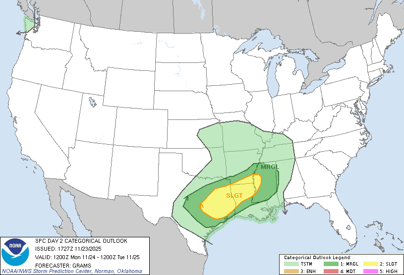 ⏰️ As far as timing goes; *Storms will come thru the northwest suburbs of Houston in the early evening.
*Most activity will lift to the north from there, bringing more numerous early evening storms up into Montgomery and Walker Counties.
*Then, the front itself pushes into the northwest suburbs with a line of thunderstorms after 8 or 9 PM.
*The line will then push across the Houston area over the next few hours, arriving at the coast between 1 & 3 AM. ........ Latest from the SPC - Storm Prediction Center RISK OF SEVERE THUNDERSTORMS IN EAST TX TO THE ARK-LA-MISS SUMMARY: Scattered severe thunderstorms are possible from Monday mid-afternoon into Monday night across east Texas into the Ark-La-Miss. A few tornadoes along with large hail and damaging winds are anticipated. SYNOPSIS: Multiple shortwave impulses embedded within a positive-tilt trough over the central to southern High Plains will move east-northeast towards the Lower OH and TN Valleys through early Tuesday. These impulses will dampen Monday night downstream of a shortwave trough digging from the Pacific Northwest into the northern Great Plains. Weak surface cyclone near the KS/OK border may decay as it tracks into the Ozarks. A warm front will advance north from south-central TX and the central Gulf Coast. 👉 CENTRAL TX TO MS: 🚨 Primary change this outlook has been to shift
expand severe probabilities east/south based on latest guidance trends. Confidence
remains too low for highlighting a mesoscale corridor of strong tornado potential with a level 3-ENHANCED risk. Elevated storms will be ongoing Monday from parts of central Texas to western Arkansas. Marginally severe hail is possible with these storms through midday. Downstream of these storms, the surface warm front will accelerate northward across east TX. Amid a rich boundary-layer moisture south of the front, a plume of moderate buoyancy will become pervasive from south into most of east TX. Primary severe potential should commence around mid-afternoon amid weak mid-level height falls and minimal inhibition. Activity should intensify/increase along the outflow from early-day convection and in confluence bands immediately downstream. Strong southwesterly deep-layer shear will support supercell structures, but convective mode will likely remain quite messy along the progressive outflow that nearly parallels the shear vector. 🧊 The more semi-discrete cells just ahead and trailing southward will have the best potential to produce large hail. 🌪 The tornado threat will be influenced by the degree of discrete convection that forms eastward in the warm sector through early evening where low-level hodograph curvature remains large. ✨️ Nocturnal tornado and some wind threat will persist into the late evening/overnight period as rich low-level moisture is maintained across the Sabine Valley and expands east through MS.
teatime reacted *Most activity will lift to the north from there, bringing more numerous early evening storms up into Montgomery and Walker Counties.
*Then, the front itself pushes into the northwest suburbs with a line of thunderstorms after 8 or 9 PM.
*The line will then push across the Houston area over the next few hours, arriving at the coast between 1 & 3 AM.
expand severe probabilities east/south based on latest guidance trends.
remains too low for highlighting a mesoscale corridor of strong tornado potential with a level 3-ENHANCED risk.
« Back to Chat
Views: 942
# Replies: 16