


Rain chances on the rise with pattern change
Rain chances on the rise with pattern change


Joined:
X days ago
# Posts:
X,XXX
Contributor Points:
X


Rain chances on the rise with pattern change *Isolated showers & thunderstorms possible this afternoon between 3 & 7pm.
*Rain chances start to increase after this weekend with much needed healthy chances every day next week. ....... From Space City Weather: Modest rain chances reenter the forecast, with a pattern change ahead. Eric Berger · Wednesday, September 17, 2025 7:19 AM In brief:
*Houston will see plenty of sunshine through the weekend, but we will also start to see some slightly better rain chances.
*By later Sunday - or more likely Monday - the pattern will change more noticeably, with increased clouds and the potential for widespread showers. A slowly changing pattern - *With one or two exceptions, most of the first half of September has seen sunny days with near zero rain chances.
*This pattern, especially over the last 10 days or so, has seen high pressure dominate our region's weather.
*This is now slowly beginning to change, and by this weekend an upper-level system will shake things up.
*As a result, we will see modest rain chances over the next couple of days before the potential for more widespread showers by Monday, which perhaps will persist for much of next week. 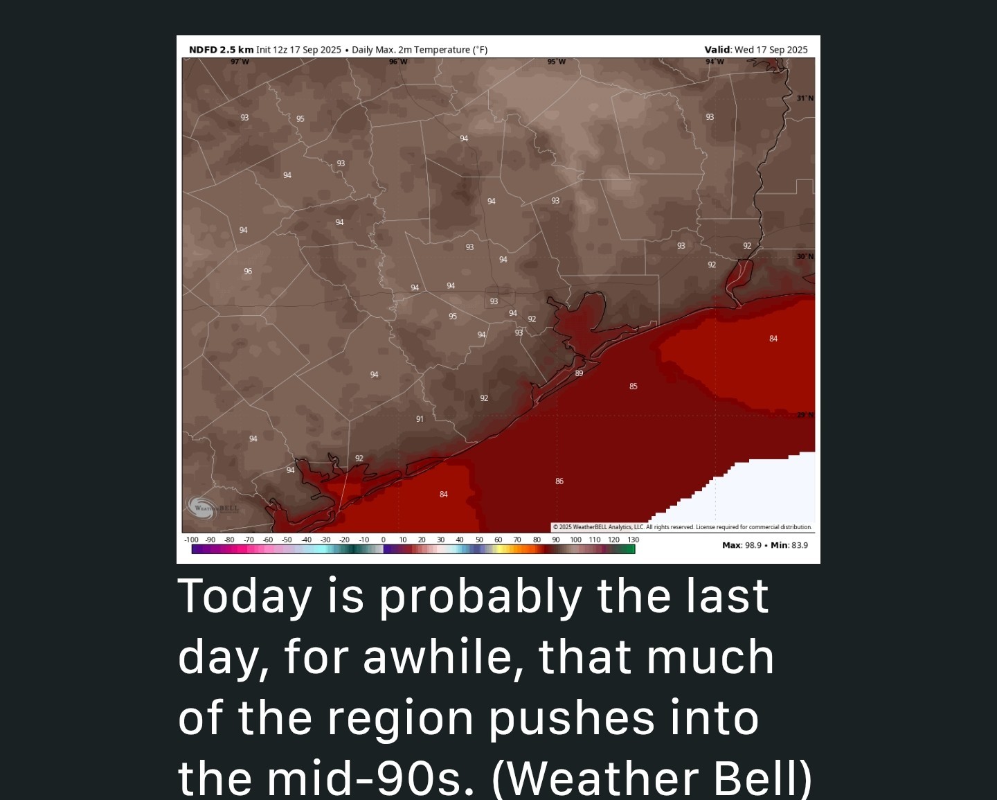 Wednesday (today) - *Today will bring sunny skies into the region with our typical temperatures in the low 90s for much of the central metro area, with inland areas getting a little warmer than this and the coast remaining a little cooler.
*There is some support in high resolution models for the development of scattered showers, and perhaps a few isolated thunderstorms, between about 3 pm and 7 pm this afternoon and early evening, before the loss of daytime heating.
*Lows tonight will drop into the mid-70s for most locations. Thursday and Friday - *Both of these days should see sunny skies.
*I do think high temperatures may be 1 or 2 degrees cooler, but it will still be hot during the afternoon.
*Rain chances both days look a bit lower, perhaps on the order of 10 to 20 percent. Saturday and Sunday - *Most of the region should see highs of around 90 degrees this weekend with mostly sunny skies.
*However, there will be a slight chance of some showers and thunderstorms as the atmosphere starts to become more unsettled.
*I think the more widespread rain chances will probably hold off until Monday, but I'm not sure of that.
*For now, I'll go with about a 20 percent chance of rain on Saturday, and maybe 40 percent on Sunday, but these are kind of fuzzy at this point. 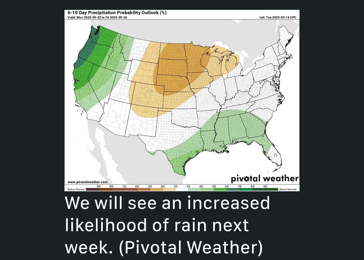 Next week - *By Monday-ish we should see an atmosphere more broadly supportive of showers and potentially some thunderstorms.
*This should set the tone for next week, with something like a 40-60 percent chance of rain each day.
*This should also limit high temperatures to about 90 degrees, or less, on a daily basis.
*As of now, there's no strong signal for the next cold front, but maybe something weaker may back door its way in later next week. We'll have to wait and see.


golfshot, GiggleMugs and larpa + 7 more reacted *Rain chances start to increase after this weekend with much needed healthy chances every day next week.
*Houston will see plenty of sunshine through the weekend, but we will also start to see some slightly better rain chances.
*By later Sunday - or more likely Monday - the pattern will change more noticeably, with increased clouds and the potential for widespread showers.
*This pattern, especially over the last 10 days or so, has seen high pressure dominate our region's weather.
*This is now slowly beginning to change, and by this weekend an upper-level system will shake things up.
*As a result, we will see modest rain chances over the next couple of days before the potential for more widespread showers by Monday, which perhaps will persist for much of next week.
*There is some support in high resolution models for the development of scattered showers, and perhaps a few isolated thunderstorms, between about 3 pm and 7 pm this afternoon and early evening, before the loss of daytime heating.
*Lows tonight will drop into the mid-70s for most locations.
*I do think high temperatures may be 1 or 2 degrees cooler, but it will still be hot during the afternoon.
*Rain chances both days look a bit lower, perhaps on the order of 10 to 20 percent.
*However, there will be a slight chance of some showers and thunderstorms as the atmosphere starts to become more unsettled.
*I think the more widespread rain chances will probably hold off until Monday, but I'm not sure of that.
*For now, I'll go with about a 20 percent chance of rain on Saturday, and maybe 40 percent on Sunday, but these are kind of fuzzy at this point.
*This should set the tone for next week, with something like a 40-60 percent chance of rain each day.
*This should also limit high temperatures to about 90 degrees, or less, on a daily basis.
*As of now, there's no strong signal for the next cold front, but maybe something weaker may back door its way in later next week.
Replies:

Rain chances on the rise with pattern change *Isolated showers & thunderstorms possible this afternoon between 3 & 7pm. *Rain chances start to increase after this weekend with much needed healthy chances every day next week. ....... From Space City Weather: Modest rain chances reenter the forecast, with a pattern change ahead. Eric Berger · Wednesday, September 17, 2025 7:19 AM In brief: *Houston will see plenty of sunshine through the weekend, but we will also start to see some slightly better rain chances. *By later Sunday - or more likely Monday - the pattern will change more noticeably, with increased clouds and the potential for widespread showers. A slowly changing pattern - *With one or two exceptions, most of the first half of September has seen sunny days with near zero rain chances. *This pattern, especially over the last 10 days or so, has seen high pressure dominate our region's weather. *This is now slowly beginning to change, and by this weekend an upper-level system will shake things up. *As a result, we will see modest rain chances over the next couple of days before the potential for more widespread showers by Monday, which perhaps will persist for much of next week. Wednesday (today) - *Today will bring sunny skies into the region with our typical temperatures in the low 90s for much of the central metro area, with inland areas getting a little warmer than this and the coast remaining a little cooler. *There is some support in high resolution models for the development of scattered showers, and perhaps a few isolated thunderstorms, between about 3 pm and 7 pm this afternoon and early evening, before the loss of daytime heating. *Lows tonight will drop into the mid-70s for most locations. Thursday and Friday - *Both of these days should see sunny skies. *I do think high temperatures may be 1 or 2 degrees cooler, but it will still be hot during the afternoon. *Rain chances both days look a bit lower, perhaps on the order of 10 to 20 percent. Saturday and Sunday - *Most of the region should see highs of around 90 degrees this weekend with mostly sunny skies. *However, there will be a slight chance of some showers and thunderstorms as the atmosphere starts to become more unsettled. *I think the more widespread rain chances will probably hold off until Monday, but I'm not sure of that. *For now, I'll go with about a 20 percent chance of rain on Saturday, and maybe 40 percent on Sunday, but these are kind of fuzzy at this point. Next week - *By Monday-ish we should see an atmosphere more broadly supportive of showers and potentially some thunderstorms. *This should set the tone for next week, with something like a 40-60 percent chance of rain each day. *This should also limit high temperatures to about 90 degrees, or less, on a daily basis. *As of now, there's no strong signal for the next cold front, but maybe something weaker may back door its way in later next week. We'll have to wait and see.
StormChaser : Thank goodness. Trying to hold off on watering and adding water to the pool. You know how I am about COH water dept friend!
Rain chances on the rise with pattern change *Isolated showers & thunderstorms possible this afternoon between 3 & 7pm.
*Rain chances start to increase after this weekend with much needed healthy chances every day next week. ....... From Space City Weather: Modest rain chances reenter the forecast, with a pattern change ahead. Eric Berger · Wednesday, September 17, 2025 7:19 AM In brief:
*Houston will see plenty of sunshine through the weekend, but we will also start to see some slightly better rain chances.
*By later Sunday - or more likely Monday - the pattern will change more noticeably, with increased clouds and the potential for widespread showers. A slowly changing pattern - *With one or two exceptions, most of the first half of September has seen sunny days with near zero rain chances.
*This pattern, especially over the last 10 days or so, has seen high pressure dominate our region's weather.
*This is now slowly beginning to change, and by this weekend an upper-level system will shake things up.
*As a result, we will see modest rain chances over the next couple of days before the potential for more widespread showers by Monday, which perhaps will persist for much of next week. Wednesday (today) - *Today will bring sunny skies into the region with our typical temperatures in the low 90s for much of the central metro area, with inland areas getting a little warmer than this and the coast remaining a little cooler.
*There is some support in high resolution models for the development of scattered showers, and perhaps a few isolated thunderstorms, between about 3 pm and 7 pm this afternoon and early evening, before the loss of daytime heating.
*Lows tonight will drop into the mid-70s for most locations. Thursday and Friday - *Both of these days should see sunny skies.
*I do think high temperatures may be 1 or 2 degrees cooler, but it will still be hot during the afternoon.
*Rain chances both days look a bit lower, perhaps on the order of 10 to 20 percent. Saturday and Sunday - *Most of the region should see highs of around 90 degrees this weekend with mostly sunny skies.
*However, there will be a slight chance of some showers and thunderstorms as the atmosphere starts to become more unsettled.
*I think the more widespread rain chances will probably hold off until Monday, but I'm not sure of that.
*For now, I'll go with about a 20 percent chance of rain on Saturday, and maybe 40 percent on Sunday, but these are kind of fuzzy at this point. Next week - *By Monday-ish we should see an atmosphere more broadly supportive of showers and potentially some thunderstorms.
*This should set the tone for next week, with something like a 40-60 percent chance of rain each day.
*This should also limit high temperatures to about 90 degrees, or less, on a daily basis.
*As of now, there's no strong signal for the next cold front, but maybe something weaker may back door its way in later next week. We'll have to wait and see.
*Rain chances start to increase after this weekend with much needed healthy chances every day next week.
*Houston will see plenty of sunshine through the weekend, but we will also start to see some slightly better rain chances.
*By later Sunday - or more likely Monday - the pattern will change more noticeably, with increased clouds and the potential for widespread showers.
*This pattern, especially over the last 10 days or so, has seen high pressure dominate our region's weather.
*This is now slowly beginning to change, and by this weekend an upper-level system will shake things up.
*As a result, we will see modest rain chances over the next couple of days before the potential for more widespread showers by Monday, which perhaps will persist for much of next week.
*There is some support in high resolution models for the development of scattered showers, and perhaps a few isolated thunderstorms, between about 3 pm and 7 pm this afternoon and early evening, before the loss of daytime heating.
*Lows tonight will drop into the mid-70s for most locations.
*I do think high temperatures may be 1 or 2 degrees cooler, but it will still be hot during the afternoon.
*Rain chances both days look a bit lower, perhaps on the order of 10 to 20 percent.
*However, there will be a slight chance of some showers and thunderstorms as the atmosphere starts to become more unsettled.
*I think the more widespread rain chances will probably hold off until Monday, but I'm not sure of that.
*For now, I'll go with about a 20 percent chance of rain on Saturday, and maybe 40 percent on Sunday, but these are kind of fuzzy at this point.
*This should set the tone for next week, with something like a 40-60 percent chance of rain each day.
*This should also limit high temperatures to about 90 degrees, or less, on a daily basis.
*As of now, there's no strong signal for the next cold front, but maybe something weaker may back door its way in later next week.
 larpa tipped StormChaser 100 credits for a post in this forum discussion.
 « Back to Chat
Views: 280
# Replies: 3