


Weekend weather
Weekend weather


Joined:
X days ago
# Posts:
X,XXX
Contributor Points:
X


Weekend weather Houston likely to face showers this weekend as another front sags into the area. Eric Berger · Thursday, September 4, 2025 7:21 AM In brief:
*The region will heat up today and Friday, with moderately drier air in place.
*A combination of factors, including a slow-moving front, will bring elevated rain chances this weekend, particularly on Sunday.
*Slightly cooler weather will follow. Thursday - *A close look at the radar reveals a few showers right along the coast this morning-that's the stalled front that has brought modestly cooler weather into the Houston region this morning.
*Lows at Conroe have dropped all the way into the mid-60s, but most of the metro area has settled into the low 70s.
*Because this dry air warms efficiently, and skies will be sunny, we will see highs today in the midto upper 90s for much of the region away from the coast.
*With dewpoints in the 60s this afternoon it will be a slightly drier heat, but it's still going to be pretty hot.
*Winds will be light, from the west at about 5 mph.
*Lows tonight will be a couple of degrees warmer than this morning. Friday - *This will be another sunny and warm day, with highs in the mid-90s for much of the area.
*However, winds will turn more southerly, with gusts up to 15 or 20 mph, and this will herald the return of the onshore flow.
*This is one factor that will lead to higher rain chances over the weekend, but only one. Friday night will see lows drop into the upper 70s. Saturday - *The first half of the weekend will see a few more clouds in the sky, but there should be enough sunshine to help push temperatures for most into the vicinity of 90 degrees, or just above.
*Rain chances are about 40 percent, but for the most part I think any showers that develop will be light to moderate, and not super impactful.
*With ample humidity in place, look for a warm Saturday night. 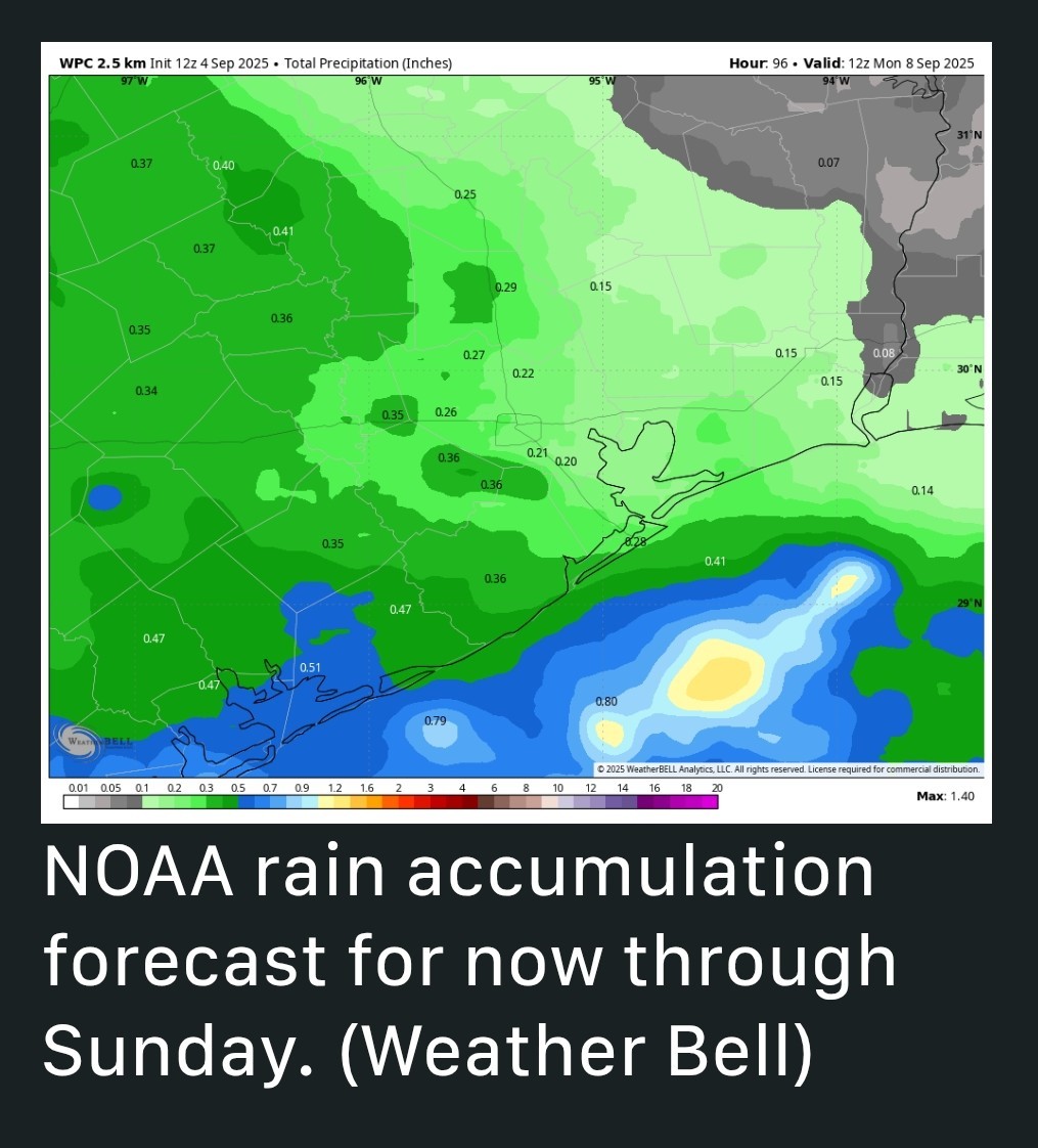 Sunday - *Rain chances will peak on Sunday, likely in the 60 to 80 percent range. Why? *Because the combination of a front dropping down from the north, along with an influx of moisture from the remnants of Hurricane Lorena in the Pacific, should bring a healthy chance of showers across the area.
*We certainly cannot rule out the threat of heavy rainfall BUT at this time I expect most of the region to pick up between 0.25 and 1 inch of rain this weekend, rather than seeing any significant flooding.
*We'll keep an eye on it.
*Highs, for the most part, should top out in the upper 80s. Next week - *At this point it looks like the front will drag into Houston on Sunday-ish, and stall out near the coast. Depending on where the front stops, we could see some lingering showers next week for coastal areas, or they should remain offshosre.
*Regardless, we should see a couple of days in the upper 80s to 90 degrees, with nights in the lower 70s.
*Some inland areas may drop into the upper 60s again, so pretty nice overall. Most of next week should be sunny.


Rocketgirl13, teatime and Wiseowl + 6 more reacted *The region will heat up today and Friday, with moderately drier air in place.
*A combination of factors, including a slow-moving front, will bring elevated rain chances this weekend, particularly on Sunday.
*Slightly cooler weather will follow.
*Lows at Conroe have dropped all the way into the mid-60s, but most of the metro area has settled into the low 70s.
*Because this dry air warms efficiently, and skies will be sunny, we will see highs today in the midto upper 90s for much of the region away from the coast.
*With dewpoints in the 60s this afternoon it will be a slightly drier heat, but it's still going to be pretty hot.
*Winds will be light, from the west at about 5 mph.
*Lows tonight will be a couple of degrees warmer than this morning.
*However, winds will turn more southerly, with gusts up to 15 or 20 mph, and this will herald the return of the onshore flow.
*This is one factor that will lead to higher rain chances over the weekend, but only one. Friday night will see lows drop into the upper 70s.
*Rain chances are about 40 percent, but for the most part I think any showers that develop will be light to moderate, and not super impactful.
*With ample humidity in place, look for a warm Saturday night.
*We certainly cannot rule out the threat of heavy rainfall BUT at this time I expect most of the region to pick up between 0.25 and 1 inch of rain this weekend, rather than seeing any significant flooding.
*We'll keep an eye on it.
*Highs, for the most part, should top out in the upper 80s.
*Regardless, we should see a couple of days in the upper 80s to 90 degrees, with nights in the lower 70s.
*Some inland areas may drop into the upper 60s again, so pretty nice overall.
Replies:
I have beach plans this weekend!! Not exactly what I wanted to see. We will make the best of it tho
Rocketgirl13, teatime and StormChaser reacted
StormChaser : Thank you for the information, as always. I'm happy about the cooler temps in the morning, and the drier air in the afternoons, and I'm ok with the rain chances as long as there is a low chance of flooding.
I have beach plans this weekend!! Not exactly what I wanted to see. We will make the best of it tho
Txbutterfly : Going to beach and probably swimming and getting wet.
So, a little rain now and then will just get you wetter.
And the added bonus is that the rain will wash off the salt water.
ExCTGuyInTX : Doing a 5k on Saturday night then hopefully hanging at resort pool and walking beach on Sunday. I dont usually get in the gulf 😀

« Back to Chat
Views: 352
# Replies: 6