


Friday forecast
Friday forecast


Joined:
X days ago
# Posts:
X,XXX
Contributor Points:
X


Friday forecast ☁️ Today looks to be similar to yesterday with isolated pop up shower chances throughout the day.
💧 Rain chances increase yet again for our weekend with greater than 50% chances each day. ☔️ 💧 Rain chances continue into Monday before we dry out for the remainder of the week.
🌀 Tropics are quiet at this time. ..................................... From Space City Weather - Rain chances persist through the weekend before proper summer heat next week. Eric Berger · Friday, July 11, 2025 7:01 AM In brief:
Houston has enjoyed a relatively mild start to July, thanks to daily rain chances helping to keep a lid on temperatures. That pattern will persist through the weekend before classic summertime heat arrives next week in the region. FRIDAY - *Houston did not see much shower activity on Thursday and I think showers and thunderstorms will be fairly scattered to isolated today as well.
*Mostly sunny skies should allow high temperatures to reach the low 90s for areas closer to the coast, and mid-90s further inland.
*Southerly winds will be a little more pronounced than we have experienced of late, perhaps gusting up to 20 mph.
*Any rains will slacken this evening with a calm night expected in the upper 70s. 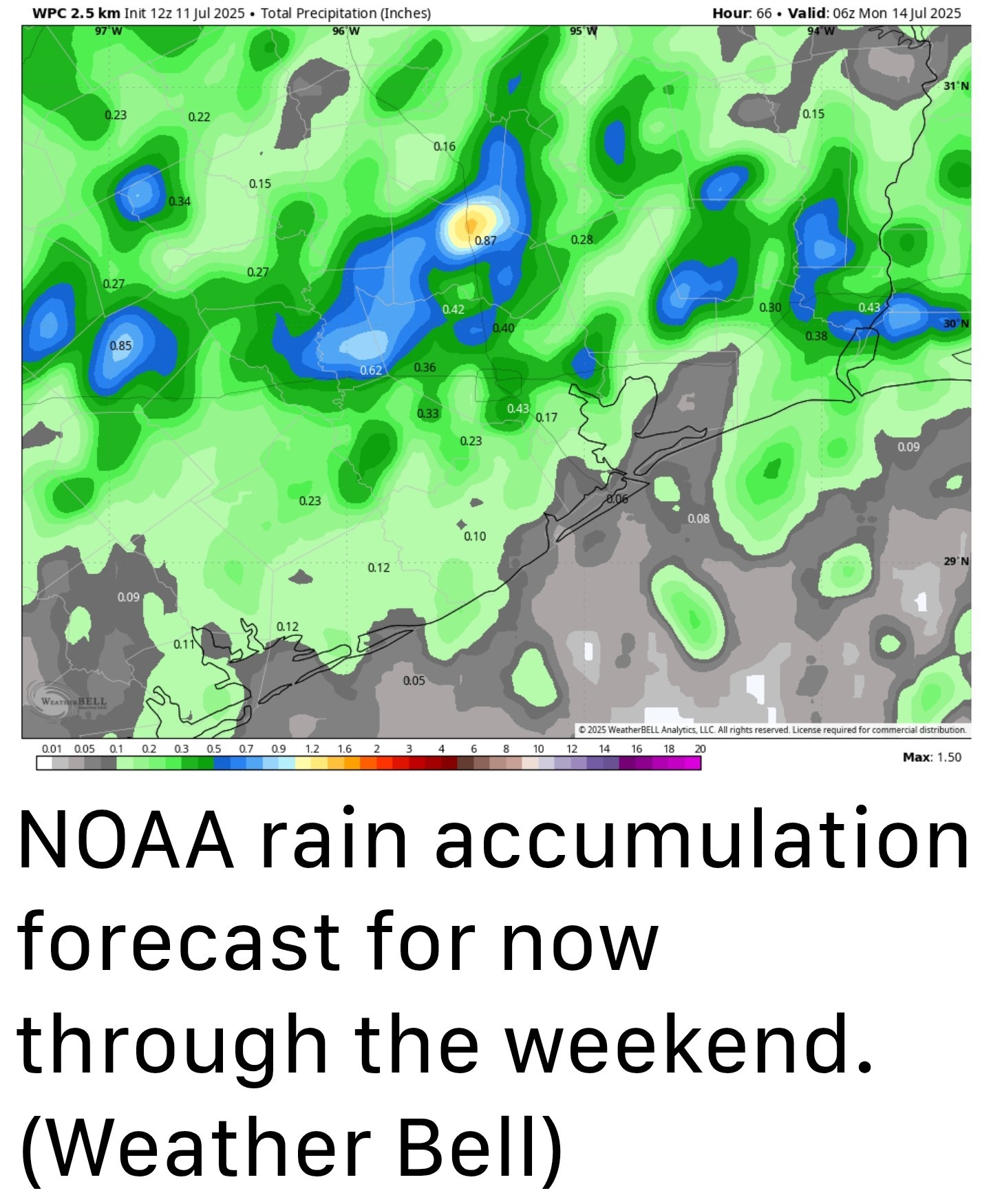 SATURDAY or SUNDAY - *Both weekend days will see healthy rain chances - likely 50 percent or higher.
*This will not be all day showers, and in fact I expect sunshine most of the time.
*It will be the kind of thing where the showers move in and move out.
*Areas along and north of Interstate 10 are most likely to see stronger showers and thunderstorms.
*Some areas may pick up a quick 1 to 2 inches of rain in the heaviest storms but most of us probably will record 0.25 inch of rain over the weekend, or less.
*Like we've been saying for several days, these showers will be hit or miss.
*Highs both days should be in the lower 90s with fairly light southerly winds. MONDAY - *This will be a bit of a transition day with highs maybe holding in the low to mid 90s and perhaps a 40 percent chance of rain.
*This is probably the last day where we can have some expectation of showers and thunderstorms. NEXT WEEK - *Highs will move into the mid to upper 90s for the rest of next week with mostly sunny days and warm, humid nights.
*I don't have much expectation of rainfall before next Saturday or Sunday, and perhaps not even then. Have a wonderful weekend, everyone! ....... A fairly mild start to July - The first 10 days of July have brought fairly mild conditions, with high temperatures generally in the low to mid 90s and overnight lows in the low to mid 70s. Rain showers and thunderstorms peppered here and there have also kept the afternoon heat from really feeling too punishing. We've been enjoying this pattern due to the region lying between two high pressure systems that have baked other parts of the country. Alas, all good things must end. Houston's weather will remain unsettled, but with mild temperatures, through Sunday or Monday. But after that we're headed into the mid and then upper 90s for much of next week as mid July brings proper Houston heat.


💧 Rain chances increase yet again for our weekend with greater than 50% chances each day. ☔️
🌀 Tropics are quiet at this time.
Houston has enjoyed a relatively mild start to July, thanks to daily rain chances helping to keep a lid on temperatures. That pattern will persist through the weekend before classic summertime heat arrives next week in the region.
*Mostly sunny skies should allow high temperatures to reach the low 90s for areas closer to the coast, and mid-90s further inland.
*Southerly winds will be a little more pronounced than we have experienced of late, perhaps gusting up to 20 mph.
*Any rains will slacken this evening with a calm night expected in the upper 70s.
*This will not be all day showers, and in fact I expect sunshine most of the time.
*It will be the kind of thing where the showers move in and move out.
*Areas along and north of Interstate 10 are most likely to see stronger showers and thunderstorms.
*Some areas may pick up a quick 1 to 2 inches of rain in the heaviest storms but most of us probably will record 0.25 inch of rain over the weekend, or less.
*Like we've been saying for several days, these showers will be hit or miss.
*Highs both days should be in the lower 90s with fairly light southerly winds.
*This is probably the last day where we can have some expectation of showers and thunderstorms.
*I don't have much expectation of rainfall before next Saturday or Sunday, and perhaps not even then.
Replies:
Friday forecast ☁️ Today looks to be similar to yesterday with isolated pop up shower chances throughout the day. 💧 Rain chances increase yet again for our weekend with greater than 50% chances each day. ☔️ 💧 Rain chances continue into Monday before we dry out for the remainder of the week. 🌀 Tropics are quiet at this time. ..................................... From Space City Weather - Rain chances persist through the weekend before proper summer heat next week. Eric Berger · Friday, July 11, 2025 7:01 AM In brief: Houston has enjoyed a relatively mild start to July, thanks to daily rain chances helping to keep a lid on temperatures. That pattern will persist through the weekend before classic summertime heat arrives next week in the region. FRIDAY - *Houston did not see much shower activity on Thursday and I think showers and thunderstorms will be fairly scattered to isolated today as well. *Mostly sunny skies should allow high temperatures to reach the low 90s for areas closer to the coast, and mid-90s further inland. *Southerly winds will be a little more pronounced than we have experienced of late, perhaps gusting up to 20 mph. *Any rains will slacken this evening with a calm night expected in the upper 70s. SATURDAY or SUNDAY - *Both weekend days will see healthy rain chances - likely 50 percent or higher. *This will not be all day showers, and in fact I expect sunshine most of the time. *It will be the kind of thing where the showers move in and move out. *Areas along and north of Interstate 10 are most likely to see stronger showers and thunderstorms. *Some areas may pick up a quick 1 to 2 inches of rain in the heaviest storms but most of us probably will record 0.25 inch of rain over the weekend, or less. *Like we've been saying for several days, these showers will be hit or miss. *Highs both days should be in the lower 90s with fairly light southerly winds. MONDAY - *This will be a bit of a transition day with highs maybe holding in the low to mid 90s and perhaps a 40 percent chance of rain. *This is probably the last day where we can have some expectation of showers and thunderstorms. NEXT WEEK - *Highs will move into the mid to upper 90s for the rest of next week with mostly sunny days and warm, humid nights. *I don't have much expectation of rainfall before next Saturday or Sunday, and perhaps not even then. Have a wonderful weekend, everyone! ....... A fairly mild start to July - The first 10 days of July have brought fairly mild conditions, with high temperatures generally in the low to mid 90s and overnight lows in the low to mid 70s. Rain showers and thunderstorms peppered here and there have also kept the afternoon heat from really feeling too punishing. We've been enjoying this pattern due to the region lying between two high pressure systems that have baked other parts of the country. Alas, all good things must end. Houston's weather will remain unsettled, but with mild temperatures, through Sunday or Monday. But after that we're headed into the mid- and then upper-90s for much of next week as mid-July brings proper Houston heat.
StormChaser : Thanks. I was drinking my coffee and wondering (based on the cloudiness) if I have time to get out and get the grass cut this morning. I hate turning on the news anymore as it is all so negative and especially now with the tragedy in the Hill country so...THANKS!
cbear : A lot of these mornings have the clouds until they burn off. Don't see much out there yet, but it can pop up
cbear : A lot of these mornings have the clouds until they burn off. Don't see much out there yet, but it can pop up
Jt88888888 : Right. Most of the Summer ...mornings have started out like today. I don't mind as it is holding temps down and ....the light bill! Haven't hit 100 yet. « Back to Chat
Views: 368
# Replies: 5