


This week's forecast
This week's forecast


Joined:
X days ago
# Posts:
X,XXX
Contributor Points:
X


This week's forecast -Look for showers and storms today as our rain chances increase yet again.
-Tomorrow & Wednesday (Esp Tuesday) look a bit concerning with high rain totals (possible street flooding) so that's something I'm watching closely.
-After Wednesday, the forecast is up in the air a bit as high pressure decides what it wants to do. .............. From Space City Weather: Storm chances return to Houston. July 7, 2025 at 6:57 am by Eric Berger. In brief: *We are going to see the return of fairly widespread showers and thunderstorms for a few days this week before coverage probably wanes some heading into the weekend. MONDAY - *After largely rain-free conditions across the region this weekend in Houston, the atmosphere above our area will become more favorable to showers and thunderstorms for the next several days.
*In the absence of high pressure, with the region open to the Gulf, rain chances will be on the order of 50 percent or higher on Monday, and likely for much of the coming week.
*Chances will peak during the late morning and afternoon hours as showers and thunderstorms spread inland.
*These storms will definitely be hit or miss, but where they "hit" they could quickly produce on the order 1 inch of rain or more.
*High temperatures will be in the low- to mid-90s with lows in the upper 70s. 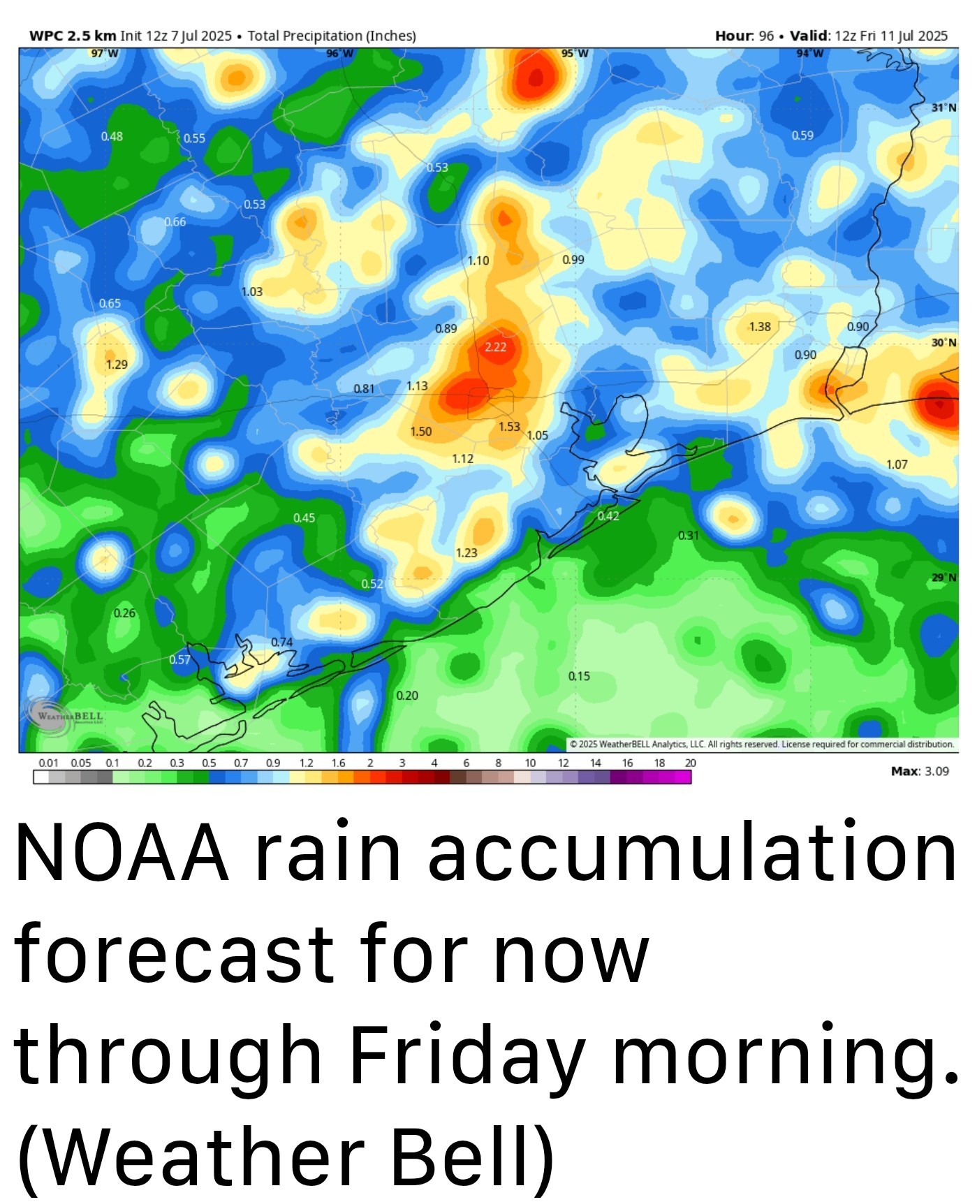 TUESDAY AND WEDNESDAY - *Rains likely peak on Tuesday and Wednesday with chances of 60 percent or higher for most of the area.
*Again, we expect some pockets of heavier rainfall in which 1 to 2 inches may fall, whereas the vast majority of Houston will probably see less.
*Daily shower chances will help to corral high temperatures in the lower 90s for much of Houston.
*Although we don't anticipate significant flooding, we are going to be watching this setup closely. THURSDAY, FRIDAY, SATURDAY, AND SUNDAY - *There is not yet a clear signal for when high pressure will return in force for the greater Houston region.
*It may happen as early as Friday or Saturday, or it may not be until some time next week.
*As a result, the forecast for this weekend is kind of fudged.
*Generally, we can probably expect high temperatures in the mid-90s.
*I estimate a ballpark ~ 30 percent chance of daily showers - but if you ask me how confident I felt in that I would say not very. (We'll likely have to adjust that number upward or downward as we get closer to the coming weekend) Hurricane map ATLANTIC TROPICS - *Tropical Storm Chantal has weakened to become a depression over the eastern United States, and is on its way to dissipating.
*Beyond this, the tropics are quiet.
*With another large plume of Saharan dust moving off of Africa, I think it's most likely that tropical activity remains low over the next week or so.
*In any case, there's nothing I'm watching that is giving me too much concern. 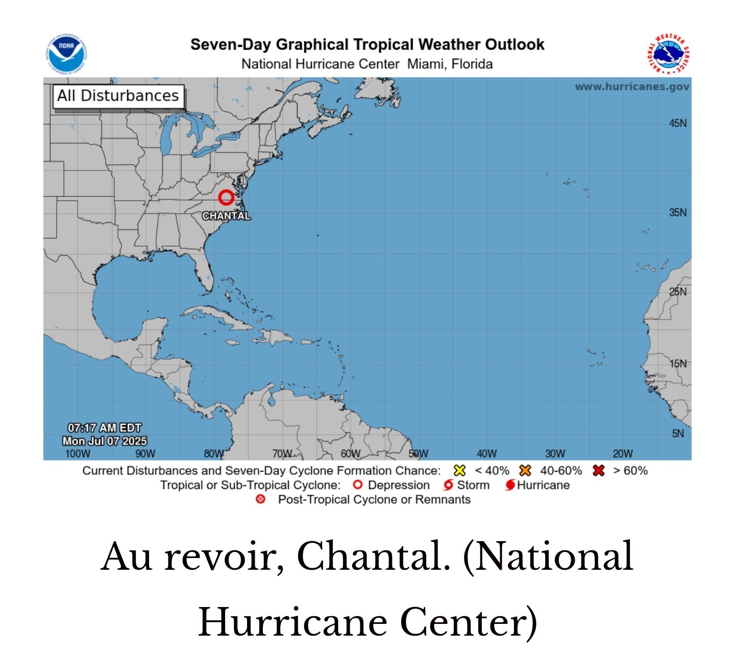 Full article plus SCW thoughts on central TX flooding: spacecityweather.com /storm-chances-retur n-to-houston-and-som e-thoughts-on-t


-Tomorrow & Wednesday (Esp Tuesday) look a bit concerning with high rain totals (possible street flooding) so that's something I'm watching closely.
-After Wednesday, the forecast is up in the air a bit as high pressure decides what it wants to do.
*In the absence of high pressure, with the region open to the Gulf, rain chances will be on the order of 50 percent or higher on Monday, and likely for much of the coming week.
*Chances will peak during the late morning and afternoon hours as showers and thunderstorms spread inland.
*These storms will definitely be hit or miss, but where they "hit" they could quickly produce on the order 1 inch of rain or more.
*High temperatures will be in the low- to mid-90s with lows in the upper 70s.
*Again, we expect some pockets of heavier rainfall in which 1 to 2 inches may fall, whereas the vast majority of Houston will probably see less.
*Daily shower chances will help to corral high temperatures in the lower 90s for much of Houston.
*Although we don't anticipate significant flooding, we are going to be watching this setup closely.
*It may happen as early as Friday or Saturday, or it may not be until some time next week.
*As a result, the forecast for this weekend is kind of fudged.
*Generally, we can probably expect high temperatures in the mid-90s.
*I estimate a ballpark ~ 30 percent chance of daily showers - but if you ask me how confident I felt in that I would say not very. (We'll likely have to adjust that number upward or downward as we get closer to the coming weekend)
*Beyond this, the tropics are quiet.
*With another large plume of Saharan dust moving off of Africa, I think it's most likely that tropical activity remains low over the next week or so.
*In any case, there's nothing I'm watching that is giving me too much concern.
Replies:

This week's forecast -Look for showers and storms today as our rain chances increase yet again. -Tomorrow & Wednesday (Esp Tuesday) look a bit concerning with high rain totals (possible street flooding) so that's something I'm watching closely. -After Wednesday, the forecast is up in the air a bit as high pressure decides what it wants to do. .............. From Space City Weather: Storm chances return to Houston. July 7, 2025 at 6:57 am by Eric Berger. In brief: *We are going to see the return of fairly widespread showers and thunderstorms for a few days this week before coverage probably wanes some heading into the weekend. MONDAY - *After largely rain-free conditions across the region this weekend in Houston, the atmosphere above our area will become more favorable to showers and thunderstorms for the next several days. *In the absence of high pressure, with the region open to the Gulf, rain chances will be on the order of 50 percent or higher on Monday, and likely for much of the coming week. *Chances will peak during the late morning and afternoon hours as showers and thunderstorms spread inland. *These storms will definitely be hit or miss, but where they "hit" they could quickly produce on the order 1 inch of rain or more. *High temperatures will be in the low- to mid-90s with lows in the upper 70s. TUESDAY AND WEDNESDAY - *Rains likely peak on Tuesday and Wednesday with chances of 60 percent or higher for most of the area. *Again, we expect some pockets of heavier rainfall in which 1 to 2 inches may fall, whereas the vast majority of Houston will probably see less. *Daily shower chances will help to corral high temperatures in the lower 90s for much of Houston. *Although we don't anticipate significant flooding, we are going to be watching this setup closely. THURSDAY, FRIDAY, SATURDAY, AND SUNDAY - *There is not yet a clear signal for when high pressure will return in force for the greater Houston region. *It may happen as early as Friday or Saturday, or it may not be until some time next week. *As a result, the forecast for this weekend is kind of fudged. *Generally, we can probably expect high temperatures in the mid-90s. *I estimate a ballpark ~ 30 percent chance of daily showers - but if you ask me how confident I felt in that I would say not very. (We'll likely have to adjust that number upward or downward as we get closer to the coming weekend) Hurricane map ATLANTIC TROPICS - *Tropical Storm Chantal has weakened to become a depression over the eastern United States, and is on its way to dissipating. *Beyond this, the tropics are quiet. *With another large plume of Saharan dust moving off of Africa, I think it's most likely that tropical activity remains low over the next week or so. *In any case, there's nothing I'm watching that is giving me too much concern. Full article plus SCW thoughts on central TX flooding: spacecityweather.com /storm-chances-retur n-to-houston-and-som e-thoughts-on-t
StormChaser : Ugh. On 1 hand, I really need it to dry out to mow. The other hand, I have had to backwash the pool alot (which loses alot of water) and so a top off would be nice. Oh well, first world problems right? « Back to Chat
Views: 308
# Replies: 2