


Wed. forecast - Tropical moisture
Wed. forecast - Tropical moisture


Joined:
X days ago
# Posts:
X,XXX
Contributor Points:
X


Wed. forecast - Tropical moisture Tropical moisture brings more downpours to Houston on Wednesday. ✳️ An area of disorganized tropical moisture (from the eastern gulf) will increase our chances for showers & thunderstorms this morning.
✳️ Rain chances will then drop this afternoon south of I10 but increase north of I-10. Some of these storms will have the chance to be severe.
✳️ This area will stay disorganized and has zero chance for any type of tropical development.
✳️ Rain chances are increasing as tropical moisture surges into Houston overnight.
✳️ This tropical moisture will remain disorganized, but these storms could drop a quick inch or two of rain that floods streets along with frequent lightning strikes that could temporarily knock out the power. ✳️ Timing - *These storms will start before sunrise from Houston to Galveston, and this early onset of the rain will keep highs for most only in the mid-to-upper 80s.
*The rain chances will drop during the afternoon from I-10 south, but the storm chances will climb north of I-10 for the afternoon.
*Those afternoon storms north of Houston could turn a bit stronger like some did late Tuesday. 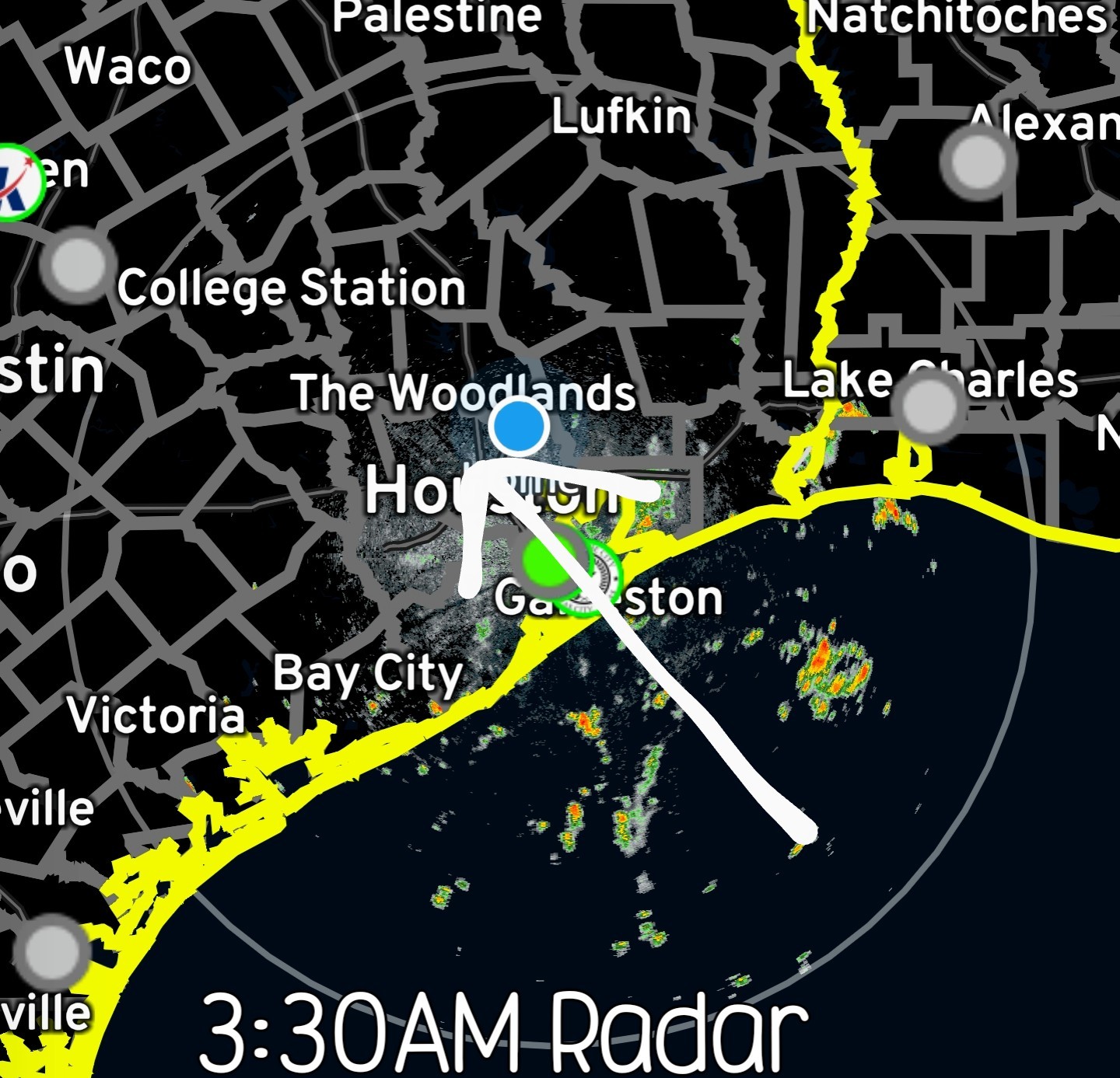 ✳️ How much longer will this wet weather last? *The tropical moisture will start moving away Wednesday night, dropping the rain chance to 40%.
*By Friday & Saturday, drier air will take over dropping the rain chance to 20% or less.
*Another wave of tropical moisture will clip us on Sunday to bring the rain chance up to 40%, then the faucet will shut off for the first days of July. HRRR 9am future radar - 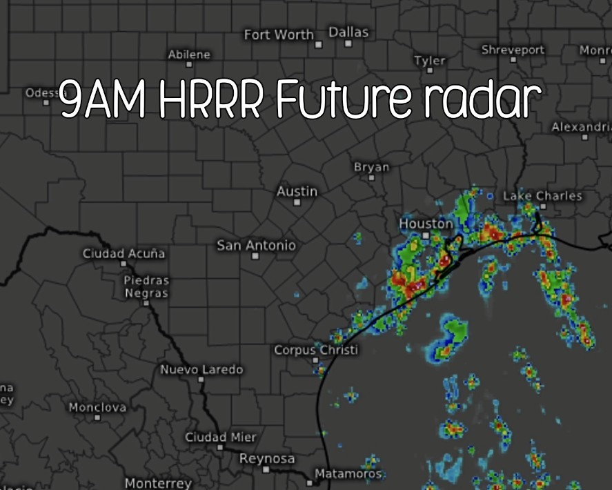


✳️ Rain chances will then drop this afternoon south of I10 but increase north of I-10. Some of these storms will have the chance to be severe.
✳️ This area will stay disorganized and has zero chance for any type of tropical development.
✳️ Rain chances are increasing as tropical moisture surges into Houston overnight.
✳️ This tropical moisture will remain disorganized, but these storms could drop a quick inch or two of rain that floods streets along with frequent lightning strikes that could temporarily knock out the power.
*The rain chances will drop during the afternoon from I-10 south, but the storm chances will climb north of I-10 for the afternoon.
*Those afternoon storms north of Houston could turn a bit stronger like some did late Tuesday.
*By Friday & Saturday, drier air will take over dropping the rain chance to 20% or less.
*Another wave of tropical moisture will clip us on Sunday to bring the rain chance up to 40%, then the faucet will shut off for the first days of July.
Replies:
I'm going to catch a nap 😴 so I'll be back on later on. I don't expect anything too crazy & I think our best chances for any heavy type showers will be this afternoon. I'm hoping we see some decent rainfall this morning as well. We'll see. 🤞 7AM radar is definitely getting a bit busier. 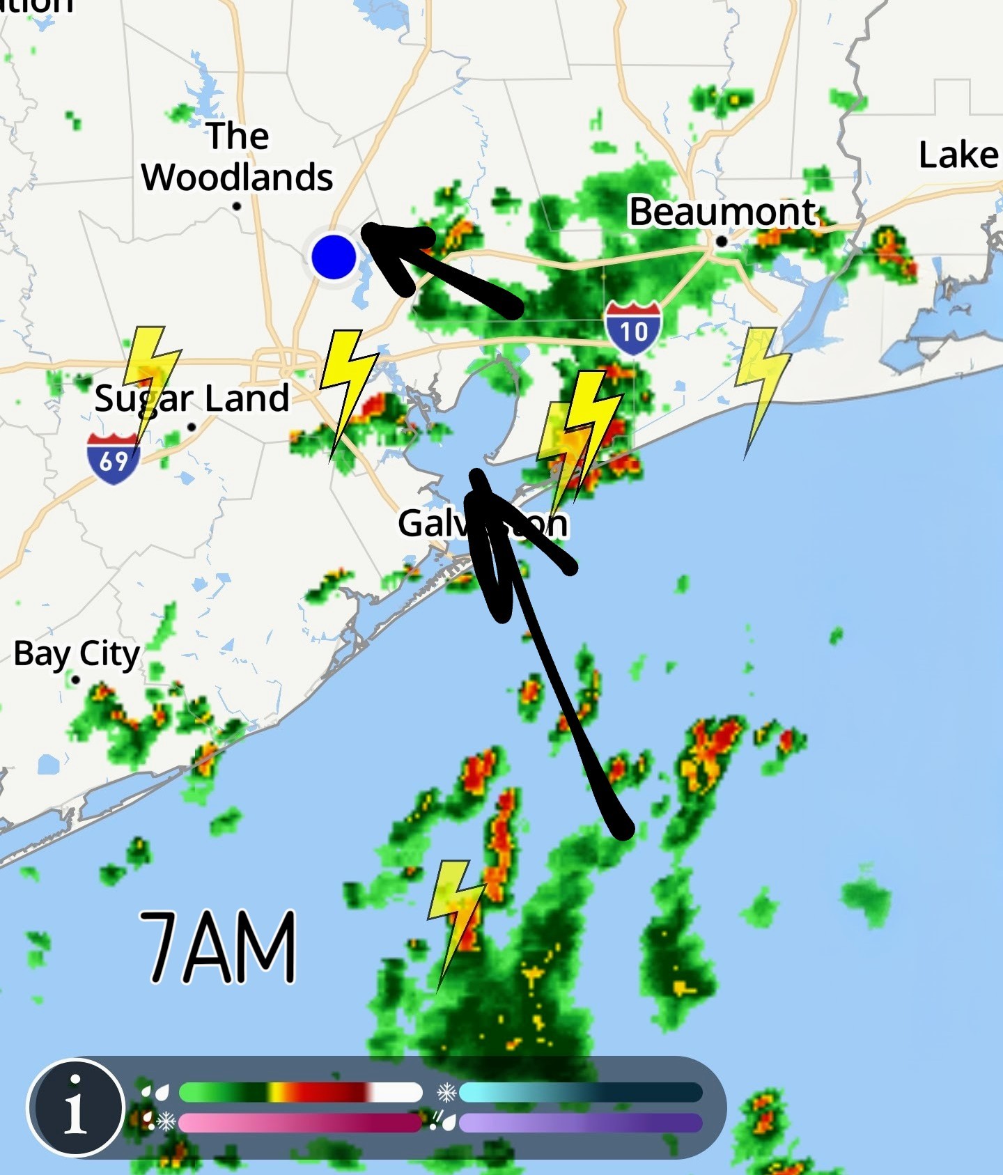 From Space City Weather - Rain and cooler temperatures will persist into this weekend before full-on summer arrives Eric Berger · Wednesday, June 25, 2025 7:01 AM In brief:
*We continue to be in an environment where showers and thunderstorms are possible, and may be numerous during the daytime.
*This pattern will hold through today and possibly Thursday before slightly drier weather.
*Later, some time next week, temperatures appear likely to soar into the mid- or upper-90s. WEDNESDAY - *Showers and thunderstorms on Tuesday were definitely hit or miss: Some areas near Tomball and Sugar Land received in excess of 1 inch, while most of the rest of the region picked up significantly less. Then, last night, more than 1 inch fell in locations near League City. This pattern is likely to continue today, with hit or miss showers and thunderstorms across the region.
*Storms should be more common near the coast this morning before spreading inland later today.
*Overall rain chances are probably on the order of 60 percent with everything from gully washers to light rain to simply ominous skies in your neighborhood.
*Flooding shouldn't be too much of an issue, but we cannot rule out some ponding on streets.
*Highs today will reach the upper 80s for most locations, but areas far inland will see a little more sunshine, and may push into the lower 90s.
*Winds will generally be light.
*Lows tonight will drop into the 70s, with decreasing rain chances.
*We continue to be in an environment where showers and thunderstorms are possible, and may be numerous during the daytime.
*This pattern will hold through today and possibly Thursday before slightly drier weather.
*Later, some time next week, temperatures appear likely to soar into the mid- or upper-90s.
*Storms should be more common near the coast this morning before spreading inland later today.
*Overall rain chances are probably on the order of 60 percent with everything from gully washers to light rain to simply ominous skies in your neighborhood.
*Flooding shouldn't be too much of an issue, but we cannot rule out some ponding on streets.
*Highs today will reach the upper 80s for most locations, but areas far inland will see a little more sunshine, and may push into the lower 90s.
*Winds will generally be light.
*Lows tonight will drop into the 70s, with decreasing rain chances.
Wed. forecast - Tropical moisture Tropical moisture brings more downpours to Houston on Wednesday. ✳️ An area of disorganized tropical moisture (from the eastern gulf) will increase our chances for showers & thunderstorms this morning.
✳️ Rain chances will then drop this afternoon south of I10 but increase north of I-10. Some of these storms will have the chance to be severe.
✳️ This area will stay disorganized and has zero chance for any type of tropical development.
✳️ Rain chances are increasing as tropical moisture surges into Houston overnight.
✳️ This tropical moisture will remain disorganized, but these storms could drop a quick inch or two of rain that floods streets along with frequent lightning strikes that could temporarily knock out the power. ✳️ Timing - *These storms will start before sunrise from Houston to Galveston, and this early onset of the rain will keep highs for most only in the mid-to-upper 80s.
*The rain chances will drop during the afternoon from I-10 south, but the storm chances will climb north of I-10 for the afternoon.
*Those afternoon storms north of Houston could turn a bit stronger like some did late Tuesday. ✳️ How much longer will this wet weather last? *The tropical moisture will start moving away Wednesday night, dropping the rain chance to 40%.
*By Friday & Saturday, drier air will take over dropping the rain chance to 20% or less.
*Another wave of tropical moisture will clip us on Sunday to bring the rain chance up to 40%, then the faucet will shut off for the first days of July. HRRR 9am future radar -
✳️ Rain chances will then drop this afternoon south of I10 but increase north of I-10. Some of these storms will have the chance to be severe.
✳️ This area will stay disorganized and has zero chance for any type of tropical development.
✳️ Rain chances are increasing as tropical moisture surges into Houston overnight.
✳️ This tropical moisture will remain disorganized, but these storms could drop a quick inch or two of rain that floods streets along with frequent lightning strikes that could temporarily knock out the power.
*The rain chances will drop during the afternoon from I-10 south, but the storm chances will climb north of I-10 for the afternoon.
*Those afternoon storms north of Houston could turn a bit stronger like some did late Tuesday.
*By Friday & Saturday, drier air will take over dropping the rain chance to 20% or less.
*Another wave of tropical moisture will clip us on Sunday to bring the rain chance up to 40%, then the faucet will shut off for the first days of July.
 malpalface tipped StormChaser 100 credits for a post in this forum discussion.
I guess I could have napped all day! I was pretty surprised to wake up to a dry ground! So much for all that rain. 🤦♀️ Hey. At least the temps are down! 😁
StormChaser : 
StormChaser : Don't worry. It will rain after my overgrown lawn is sacrificed to the rain gods. Soon...soon...
CountFloyd : I'm counting on you!
StormChaser : Don't count on me. That cat's been overbooked lately. I trust him to get out here but he's a few days off so far. I feel bad. He's been overworked.

Wed. forecast - Tropical moisture Tropical moisture brings more downpours to Houston on Wednesday. ✳️ An area of disorganized tropical moisture (from the eastern gulf) will increase our chances for showers & thunderstorms this morning. ✳️ Rain chances will then drop this afternoon south of I10 but increase north of I-10. Some of these storms will have the chance to be severe. ✳️ This area will stay disorganized and has zero chance for any type of tropical development. ✳️ Rain chances are increasing as tropical moisture surges into Houston overnight. ✳️ This tropical moisture will remain disorganized, but these storms could drop a quick inch or two of rain that floods streets along with frequent lightning strikes that could temporarily knock out the power. ✳️ Timing - *These storms will start before sunrise from Houston to Galveston, and this early onset of the rain will keep highs for most only in the mid-to-upper 80s. *The rain chances will drop during the afternoon from I-10 south, but the storm chances will climb north of I-10 for the afternoon. *Those afternoon storms north of Houston could turn a bit stronger like some did late Tuesday. ✳️ How much longer will this wet weather last? *The tropical moisture will start moving away Wednesday night, dropping the rain chance to 40%. *By Friday & Saturday, drier air will take over dropping the rain chance to 20% or less. *Another wave of tropical moisture will clip us on Sunday to bring the rain chance up to 40%, then the faucet will shut off for the first days of July. HRRR 9am future radar -
StormChaser : Come to mama little storm!!
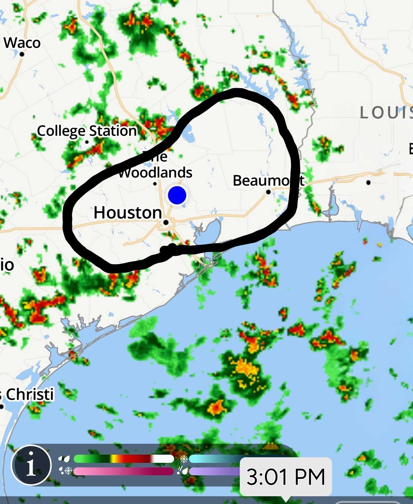

StormChaser : Damn, the Bubble is growing
asasolid2r : asasolid2r : For real.
StormChaser : Nah....I betcha the "Kingwood bubble" will keep it away. Who wants to bet?
⬆️⬆️⬆️⬆️⬆️⬆️⬆️⬆️⬆️⬆️⬆️ This is some serious ********. 🙄 Every. Damn. Day. this spring!
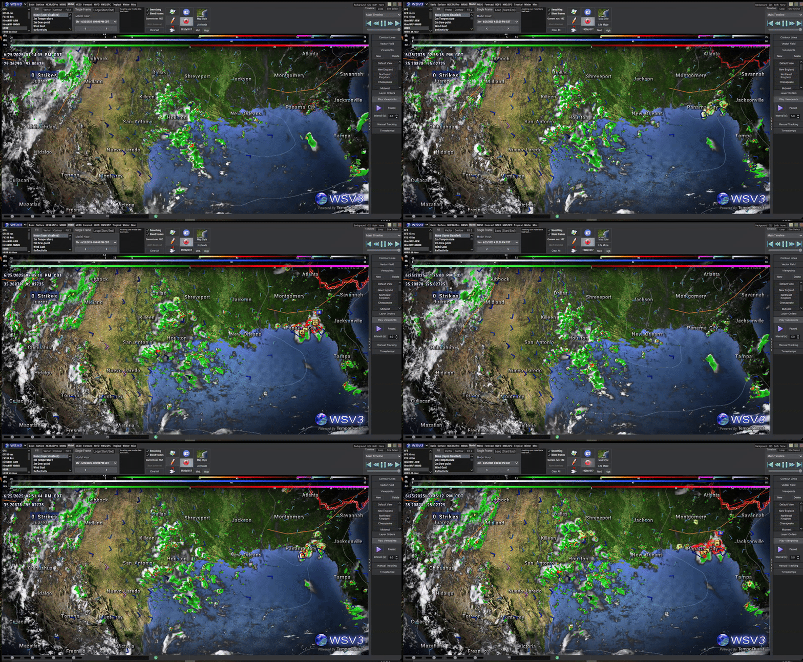 StormChaser : A lot of the wet stuff out there. Just maybe.
StormChaser : A lot of the wet stuff out there. Just maybe.
Slow4x4 : A big ole goose egg! 🥚 Again! 🥹
« Back to Chat
Views: 688
# Replies: 15