


This week's forecast
This week's forecast


Joined:
X days ago
# Posts:
X,XXX
Contributor Points:
X


This week's forecast From Space City Weather: Houston to be warm, windy, and humid for awhile; Rain chances return for the second half of the week. Eric Berger · Monday, April 28, 2025 7:16 AM In brief: *Did you like Sunday's weather? Because that pattern will persist into Wednesday.
*After that point we'll add daily rain chances into the forecast through the weekend.
*However, one thing that won't change is the relatively high temperatures & humidity we've been experiencing. MONDAY: *High pressure will prevail to start the week, so we are likely to see ongoing warm and humid weather for a few days.
*For Monday, this means partly cloudy skies, with high temperatures in the mid-80s.
*Like on Sunday, we will see fairly stiff southerly winds at about 15 mph, with gusts up to 25 mph.
*Rain chances will be low to non-existent. Skies will remain mostly cloudy overnight, with low temperatures dropping to around 70 degrees. TUESDAY: *This should more or less be a carbon copy of Monday, albeit with high and low temperatures perhaps a degree or two higher.
*Again, with high pressure in place, rain chances should remain near zero. WEDNESDAY: *The forecast turns slightly more dynamic on Wednesday as a cool front approaches the region but, more likely than not, stalls out well to the northwest of the metro area.
*Although we will be watching for the possibility that the front pushes into Houston, right now the most probable weather is scattered showers (greater chances north of I-10) on Wednesday afternoon, evening, and overnight. ☔️
*Expect highs generally in the mid-80s with mostly cloudy skies.
*Those pesky, strong southerly winds will remain in place. I don't think we'll see enough oomph from the front to make a meaningful impact on nighttime temperatures. THURSDAY AND FRIDAY: *With clearer skies these days should see highs in the upper 80s to 90 degrees for most of the area, with nighttime lows around 70 degrees.
*However, each day may see some scattered shower activity during the afternoon and evening hours with daytime heating. 🌧
*I'm confident in the heat, but less so in the rain chances. 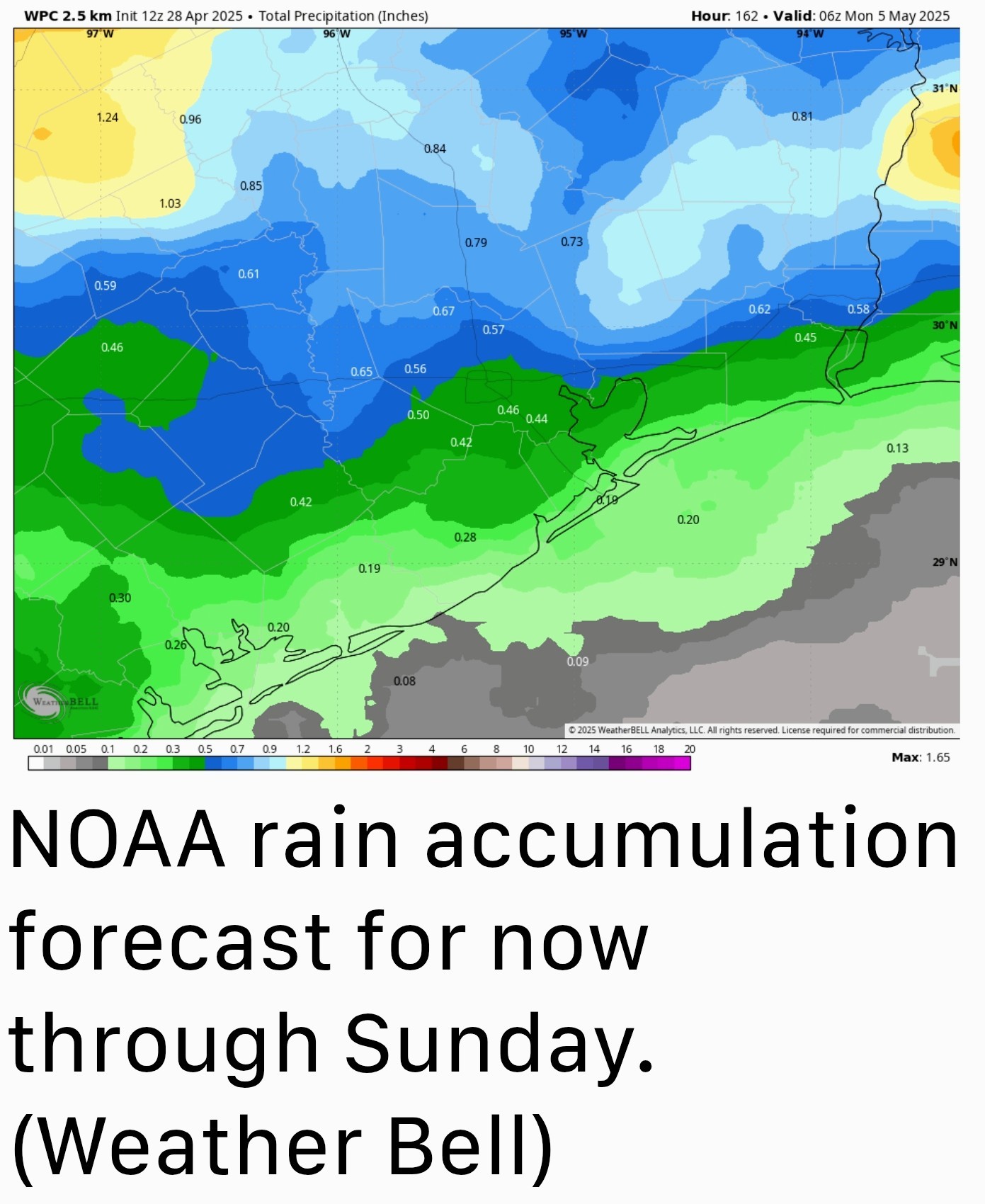 SATURDAY & SUNDAY: *With a fair amount of moisture lingering in the atmosphere, we should continue to see daily rain chances in the vicinity of 30-50 percent this weekend. ☔️💧
*With a few more clouds, high temperatures may back off into the mid-80s, with continued nighttime lows around 70 degrees.
*With dewpoints in the 60s, it will definitely feel humid outside, but not oppressively so like it will in a month or two. NEXT WEEK: *Most of our modeling is showing another system that could bring elevated rain chances by the middle of next week.
*However, as this feature is about 10 days away, it is difficult to place too much confidence in any one outcome at this time. .... A QUICK WORD ON THE SUN: 🌞 *The calendar may still say spring - but in terms of sunshine - we are rapidly approaching the peak of the year. *Nowadays, shortly after 1 pm, the 🌞 reaches an angle of 75 degrees (out of a maximum of 90 degrees) in the sky.
*Of course the 🌞 reaches a maximum height on the summer solstice (June 21 this year, 84 degrees), but the 🌞 is already climbing to the same height as it does in early August. What's your point, Eric? 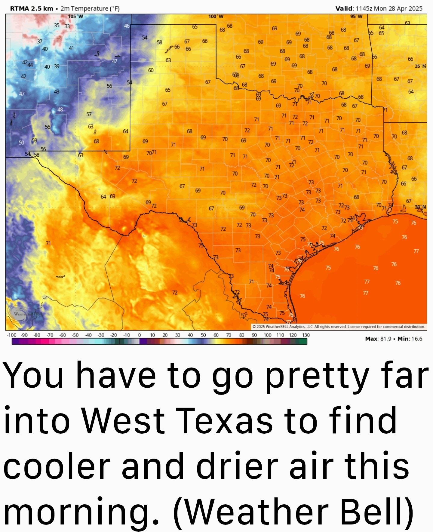 *Well I think a lot of Houston residents associate August with a month when you can pretty quickly get a sunburn outside.
*My point is that similar conditions exist in April, so if you're planning to be outside during the middle of the day, please take some precautions to protect your skin - It will burn quickly. 🥵

*After that point we'll add daily rain chances into the forecast through the weekend.
*However, one thing that won't change is the relatively high temperatures & humidity we've been experiencing.
*For Monday, this means partly cloudy skies, with high temperatures in the mid-80s.
*Like on Sunday, we will see fairly stiff southerly winds at about 15 mph, with gusts up to 25 mph.
*Rain chances will be low to non-existent. Skies will remain mostly cloudy overnight, with low temperatures dropping to around 70 degrees.
*Again, with high pressure in place, rain chances should remain near zero.
*Although we will be watching for the possibility that the front pushes into Houston, right now the most probable weather is scattered showers (greater chances north of I-10) on Wednesday afternoon, evening, and overnight. ☔️
*Expect highs generally in the mid-80s with mostly cloudy skies.
*Those pesky, strong southerly winds will remain in place. I don't think we'll see enough oomph from the front to make a meaningful impact on nighttime temperatures.
*However, each day may see some scattered shower activity during the afternoon and evening hours with daytime heating. 🌧
*I'm confident in the heat, but less so in the rain chances.
*With a few more clouds, high temperatures may back off into the mid-80s, with continued nighttime lows around 70 degrees.
*With dewpoints in the 60s, it will definitely feel humid outside, but not oppressively so like it will in a month or two.
*However, as this feature is about 10 days away, it is difficult to place too much confidence in any one outcome at this time.
*Of course the 🌞 reaches a maximum height on the summer solstice (June 21 this year, 84 degrees), but the 🌞 is already climbing to the same height as it does in early August.
*My point is that similar conditions exist in April, so if you're planning to be outside during the middle of the day, please take some precautions to protect your skin - It will burn quickly. 🥵
Replies:
This week's forecast From Space City Weather: Houston to be warm, windy, and humid for awhile; Rain chances return for the second half of the week. Eric Berger · Monday, April 28, 2025 7:16 AM In brief: *Did you like Sunday's weather? Because that pattern will persist into Wednesday. *After that point we'll add daily rain chances into the forecast through the weekend. *However, one thing that won't change is the relatively high temperatures & humidity we've been experiencing. MONDAY: *High pressure will prevail to start the week, so we are likely to see ongoing warm and humid weather for a few days. *For Monday, this means partly cloudy skies, with high temperatures in the mid-80s. *Like on Sunday, we will see fairly stiff southerly winds at about 15 mph, with gusts up to 25 mph. *Rain chances will be low to non-existent. Skies will remain mostly cloudy overnight, with low temperatures dropping to around 70 degrees. TUESDAY: *This should more or less be a carbon copy of Monday, albeit with high and low temperatures perhaps a degree or two higher. *Again, with high pressure in place, rain chances should remain near zero. WEDNESDAY: *The forecast turns slightly more dynamic on Wednesday as a cool front approaches the region but, more likely than not, stalls out well to the northwest of the metro area. *Although we will be watching for the possibility that the front pushes into Houston, right now the most probable weather is scattered showers (greater chances north of I-10) on Wednesday afternoon, evening, and overnight. ☔️ *Expect highs generally in the mid-80s with mostly cloudy skies. *Those pesky, strong southerly winds will remain in place. I don't think we'll see enough oomph from the front to make a meaningful impact on nighttime temperatures. THURSDAY AND FRIDAY: *With clearer skies these days should see highs in the upper 80s to 90 degrees for most of the area, with nighttime lows around 70 degrees. *However, each day may see some scattered shower activity during the afternoon and evening hours with daytime heating. 🌧 *I'm confident in the heat, but less so in the rain chances. SATURDAY & SUNDAY: *With a fair amount of moisture lingering in the atmosphere, we should continue to see daily rain chances in the vicinity of 30-50 percent this weekend. ☔️💧 *With a few more clouds, high temperatures may back off into the mid-80s, with continued nighttime lows around 70 degrees. *With dewpoints in the 60s, it will definitely feel humid outside, but not oppressively so like it will in a month or two. NEXT WEEK: *Most of our modeling is showing another system that could bring elevated rain chances by the middle of next week. *However, as this feature is about 10 days away, it is difficult to place too much confidence in any one outcome at this time. .... A QUICK WORD ON THE SUN: 🌞 *The calendar may still say spring - but in terms of sunshine - we are rapidly approaching the peak of the year. *Nowadays, shortly after 1 pm, the 🌞 reaches an angle of 75 degrees (out of a maximum of 90 degrees) in the sky. *Of course the 🌞 reaches a maximum height on the summer solstice (June 21 this year, 84 degrees), but the 🌞 is already climbing to the same height as it does in early August. What's your point, Eric? *Well I think a lot of Houston residents associate August with a month when you can pretty quickly get a sunburn outside. *My point is that similar conditions exist in April, so if you're planning to be outside during the middle of the day, please take some precautions to protect your skin - It will burn quickly. 🥵
StormChaser : The only good thing I like about summer is it's ending!

|
The only thing I like about summer is it's ending!
Ruger5 : Ahhhhh remember the humidity is good for the skin haha. 
« Back to Chat
Views: 1,259
# Replies: 2