


Oohhhhh very true!
Oohhhhh very true!


Joined:
X days ago
# Posts:
X,XXX
Contributor Points:
X


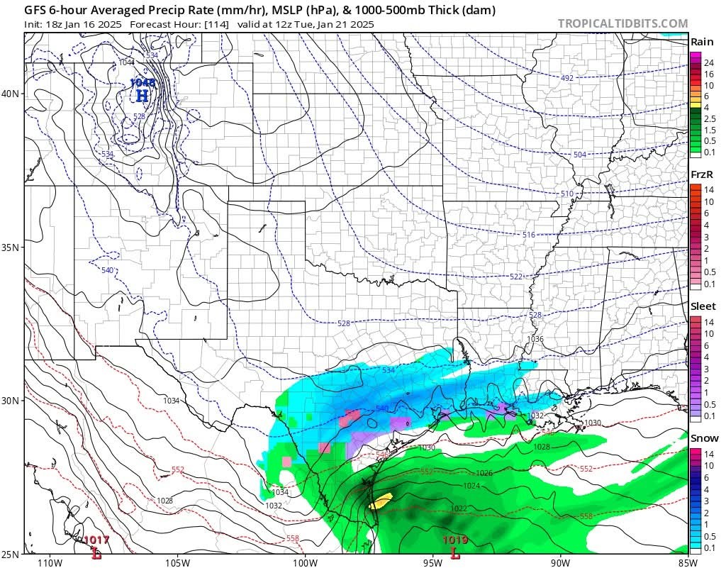
Oohhhhh very true! ❄️❄️❄️ Frank Billingsley brought up a good point. We had a hurricane this season! We had snow the winter following both Ike & Harvey. From Frank: Snow Monday Night into Tuesday Morning? Well....we did have a hurricane this past summer and you know how that works, right? .......... Models are starting to agree and some models show decent accumulations! 1-3"? Maybe more? ❄️ This would happen late Monday night and into Tuesday morning. (Tues AM looks to be our best chance) New Euro & GFS models coming into agreement! 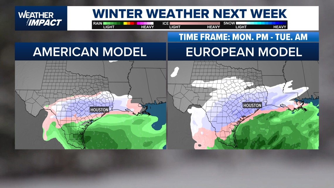


Discussion Summary:
"Discussion on Possible Snow Accumulation Following Hurricane Season: Insights from Frank Billingsley and Weather Models"
"Discussion on Possible Snow Accumulation Following Hurricane Season: Insights from Frank Billingsley and Weather Models"
Discussion Insights:
Ask a question about this discussion and an AI bot will try to give an answer.
Ask a question about this discussion and an AI bot will try to give an answer.
Replies:
It has always been said when we have a hurricane it will snow 🌨️ it's coming true.

My sweet Buddy would love some snow. She is very active in this cooler weather poor furry beast! Lol
Oohhhhh very true! ❄️❄️❄️ Frank Billingsley brought up a good point. We had a hurricane this season! We had snow the winter following both Ike & Harvey. From Frank: Snow Monday Night into Tuesday Morning? Well....we did have a hurricane this past summer and you know how that works, right? .......... Models are starting to agree and some models show decent accumulations! 1-3"? Maybe more? ❄️ This would happen late Monday night and into Tuesday morning. (Tues AM looks to be our best chance) New Euro & GFS models coming into agreement!
StormChaser : That's it then! Im officially praying for snow. For the littles ya know. How very magical for them, many of whom have never seen snow. It'll be a childhood memory they never forget. How awesome. I just pray people don't lose power in below freezing temps 🙏🙏🙏🙏🙏. Thanks for the updates!

|
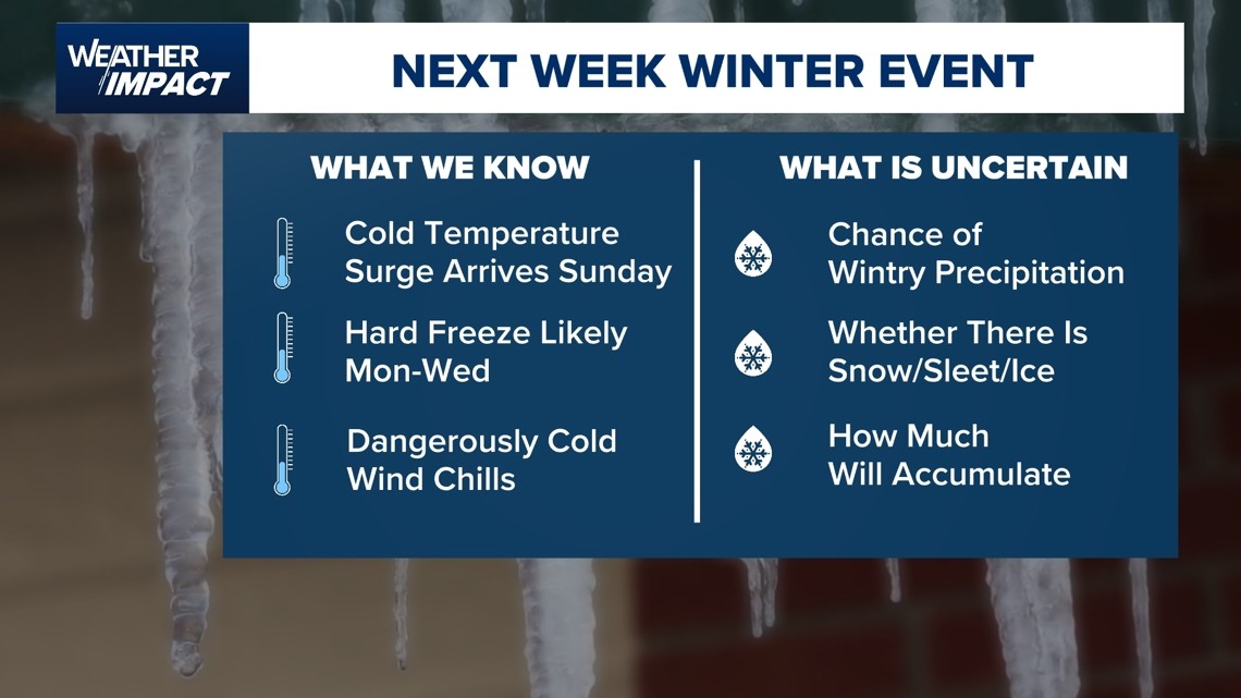
From the National Weather Service Winter Storm and Hard Freeze Risk Grows. ❄️ Chance of frozen precipitation continues to increase during the Monday night to Tuesday time frame.
❄️ In addition, the risk of a hard freeze is expanding southward, especially for Tuesday night into Wednesday morning. ❄️ Worth mentioning that there are a lot of moving parts to this forecast.
❄️ It's also worth mentioning that the storm is not within range of the higher resolution short term model guidance yet.
❄️ Therefore, this forecast could easily change. We will have some short-term higher resolution data later today. More of that data will be available tomorrow. ❄️ This weekend is a good time to prepare and monitor forecast changes. 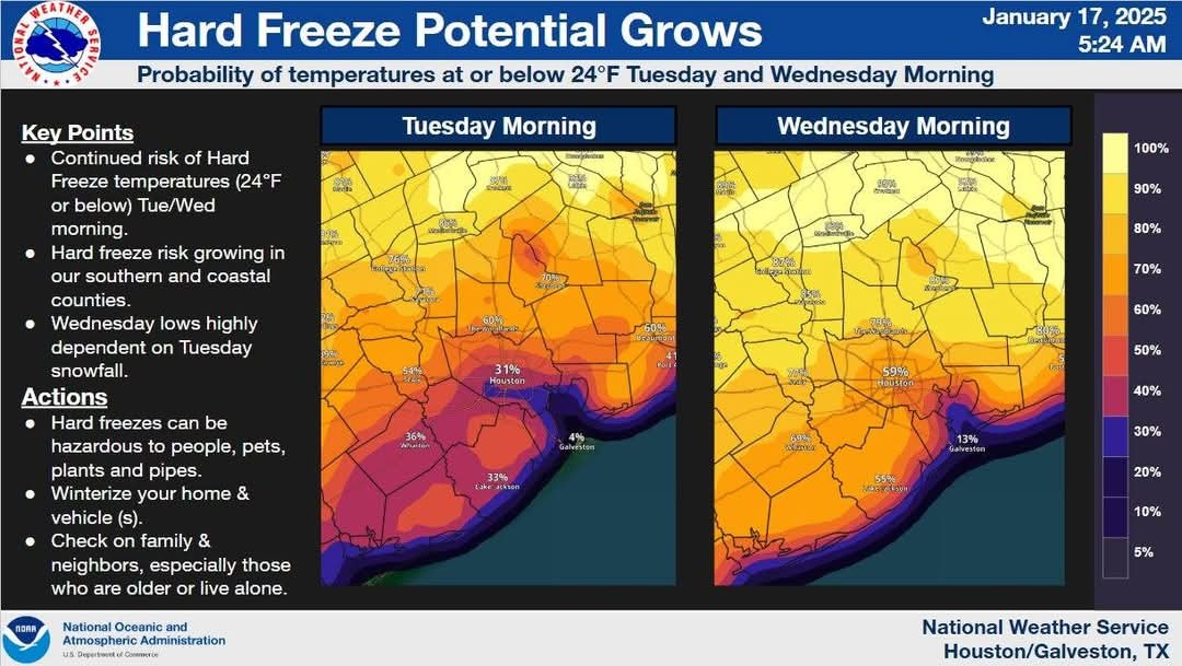
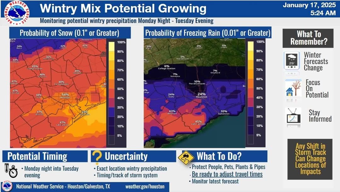
❄️ In addition, the risk of a hard freeze is expanding southward, especially for Tuesday night into Wednesday morning.
❄️ It's also worth mentioning that the storm is not within range of the higher resolution short term model guidance yet.
❄️ Therefore, this forecast could easily change. We will have some short-term higher resolution data later today. More of that data will be available tomorrow.
I have said this for years, since my now grown kids were children. Get a hurricane or tropical storm, our chances go up of having colder weather for a long spell along with sleet or rain.
|
|
Oohhhhh very true! ❄️❄️❄️ Frank Billingsley brought up a good point. We had a hurricane this season! We had snow the winter following both Ike & Harvey. From Frank: Snow Monday Night into Tuesday Morning? Well....we did have a hurricane this past summer and you know how that works, right? .......... Models are starting to agree and some models show decent accumulations! 1-3"? Maybe more? ❄️ This would happen late Monday night and into Tuesday morning. (Tues AM looks to be our best chance) New Euro & GFS models coming into agreement!
StormChaser : I personally believe in this theory of snow following a storm. Lucky us!
|
|
StormChaser : Frank is my guy even in retirement! I'm glad he still continues to look out for us and keep us abreast of the weather.
|
|
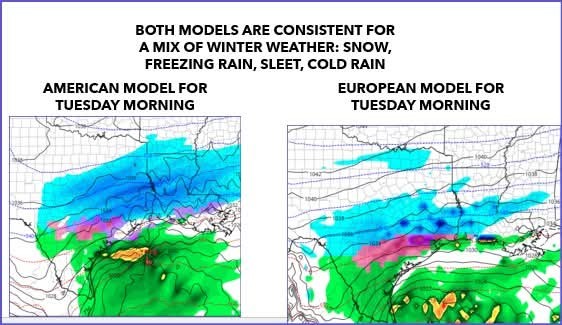
I swear, if we 11 inches of snow?!? 🤦♀️ American GFS models show 7-11 inches over our area while the Euro model shows more of a snow/sleet/ice mix which would make our roads a MESS. American and European models are now consistent (which is good), but overnight runs suggest more of a mix of freezing rain and snow for Houston for Monday night-Tuesday morning which is the worst for driving conditions Tuesday. Snow amounts are significant from the American model. As for temperatures, upper 20s for Houston Monday/Tuesday mornings with mid 20s Wednesday morning, then warming up.
Chevron Houston marathon: Cold upper 30s with a 15-20mph north wind bringing wind chills to the upper 20s. Dry.
MLK Day parades: Mid 30s feeling like mid 20s and still a strong north wind, but dry. Bundle up! 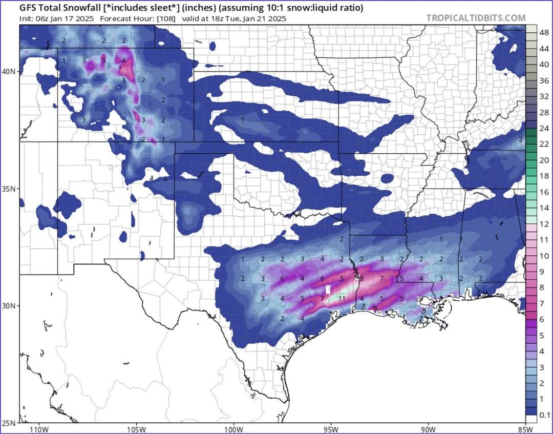
Chevron Houston marathon: Cold upper 30s with a 15-20mph north wind bringing wind chills to the upper 20s. Dry.
MLK Day parades: Mid 30s feeling like mid 20s and still a strong north wind, but dry. Bundle up!
|
|
e : I was thinking we didn't have a hurricane in 2020, but that was very ecocentric of me...poor Lake Charles that year.
Channel 13 weather predicting 19 degrees Wednesday morning?!? Whoa!!

« Back to Chat
Views: 1,144
# Replies: 18