


Removed By Request.
Removed By Request.

This discussion has been locked.

Joined:
X days ago
# Posts:
X,XXX
Contributor Points:
X


Discussion Summary:
Houston Weekend Storm Forecast: Potential for Heavy Rain and Flooding, Cooler Weather Ahead
Houston Weekend Storm Forecast: Potential for Heavy Rain and Flooding, Cooler Weather Ahead
Discussion Insights:
Ask a question about this discussion and an AI bot will try to give an answer.
Ask a question about this discussion and an AI bot will try to give an answer.
Replies:


City of Houston getting ready according to KHOU, Channel 11: " With heavy rain in the forecast, city plans to drop water levels at Lake Houston Beginning Saturday morning at 4 a.m., the water level at Lake Houston will be dropped by 12 inches. People living along the lake should secure their belongings."
www.khou.com/article /weather/heavy-rain- lake-houston-lowered -texas-weather/
www.khou.com/article /weather/heavy-rain- lake-houston-lowered -texas-weather/
 StormChaser :
yep, just when I have something to go and do, and I do Not want to be a fuzzy hairball...; D

|
Good. Did some damage at Warren's today. Need more rain.
Storm forecast; late Sat PM - Sun AM. 💧Weekend storm forecast for late Sat afternoon - Sun AM with a flooding potential setting up to the north of Houston.
💧Our biggest hazards here will be gusty winds, possibly some small hail and heavy rainfall at times. ........... From Space City Weather: Pleasant weather is in sight for a couple days, but first Houston must deal with some rain and storms this weekend. April 19, 2024 at 6:46 am by Matt Lanza Summary: - Cooler weather is in sight as we head later into the weekend.
- Until then, it will be warm (hot) and humid, and there will likely be heavy rain and strong storms north and northwest of Houston on Saturday evening.
- If you're traveling north and west toward Austin, Waco, or Dallas Saturday afternoon or evening, use caution. â›ˆï¸ SATURDAY - INTO SUNDAY AM The forecast gets interesting here. â›ˆï¸ As of now, Saturday morning looks warm, humid, but otherwise fine.
â›ˆï¸ An isolated shower or storm is possible from late morning into early afternoon.
â›ˆï¸ By mid to late afternoon, storm coverage should increase. Here's how we expect it to go down right now: â›ˆï¸ Storms could develop in the Houston area, along and north or west of US59/I69 after 2 to 3 PM.
â›ˆï¸ I suspect those storms will lift north and west a bit and eventually line up robustly between College Station and Huntsville.
â›ˆï¸ There is some signal within the models of training storms up that way, so rain could continue to repetitively cycle over the same areas a bit.
â›ˆï¸ Eventually, as the front plows south and east, all of those storms will come with it. â›ˆï¸ This should sweep back through the Greater Houston area between midnight and 5 AM or so & will continue to progress east and out of our area on Sunday. 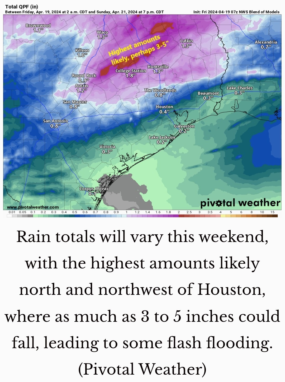 How much rain? 💦 I think we're going to see a lot of variability, truthfully.
💦 From Houston south and east, probably a half-inch or less, unless the overnight storms pack more punch than we currently expect.
💦 Within Houston and the immediate suburbs north and west (Katy through Cypress and The Woodlands), we will probably see anywhere from a quarter-inch to an inch (or more) in an isolated spot or two.
💦 Further north & west (along a line from about La Grange through College Station through Huntsville) rain totals will likely average 1 - 3 inches.
💦💧 I would not be the least bit shocked to see someone end up with 5 inches or even a little more out of this.
💧◠Flash flooding is a definite possibility up that way, and if you're traveling between Houston and Dallas, Waco, or Austin tomorrow afternoon or evening, just be aware of this potential. â˜€ï¸ Saturday's highs will again be in the 80's with morning lows in the 70's.
â˜€ï¸ Temperatures should drop into the 60's with the storms Sunday morning before recovering back to near 70 degrees in the afternoon.
â˜€ï¸ It will be noticeably cooler and breezy. â˜€ï¸ By Sunday afternoon things will clear out & the humidity will take a plunge! NEXT WEEK â˜€ï¸ Monday looks absolutely spectacular for late April.
â˜€ï¸ Expect lows in the 50's (or even a handful of 40's!), highs in the low to mid 70s, and plentiful sunshine. 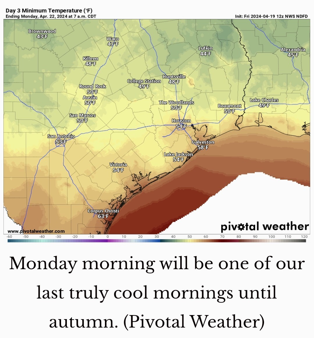
💧Our biggest hazards here will be gusty winds, possibly some small hail and heavy rainfall at times.
- Until then, it will be warm (hot) and humid, and there will likely be heavy rain and strong storms north and northwest of Houston on Saturday evening.
- If you're traveling north and west toward Austin, Waco, or Dallas Saturday afternoon or evening, use caution.
â›ˆï¸ An isolated shower or storm is possible from late morning into early afternoon.
â›ˆï¸ By mid to late afternoon, storm coverage should increase.
â›ˆï¸ I suspect those storms will lift north and west a bit and eventually line up robustly between College Station and Huntsville.
â›ˆï¸ There is some signal within the models of training storms up that way, so rain could continue to repetitively cycle over the same areas a bit.
â›ˆï¸ Eventually, as the front plows south and east, all of those storms will come with it.
💦 From Houston south and east, probably a half-inch or less, unless the overnight storms pack more punch than we currently expect.
💦 Within Houston and the immediate suburbs north and west (Katy through Cypress and The Woodlands), we will probably see anywhere from a quarter-inch to an inch (or more) in an isolated spot or two.
💦 Further north & west (along a line from about La Grange through College Station through Huntsville) rain totals will likely average 1 - 3 inches.
💦💧 I would not be the least bit shocked to see someone end up with 5 inches or even a little more out of this.
💧◠Flash flooding is a definite possibility up that way, and if you're traveling between Houston and Dallas, Waco, or Austin tomorrow afternoon or evening, just be aware of this potential.
â˜€ï¸ Temperatures should drop into the 60's with the storms Sunday morning before recovering back to near 70 degrees in the afternoon.
â˜€ï¸ It will be noticeably cooler and breezy.
â˜€ï¸ Expect lows in the 50's (or even a handful of 40's!), highs in the low to mid 70s, and plentiful sunshine.
 Joe tipped StormChaser 100 credits for a post in this forum discussion.
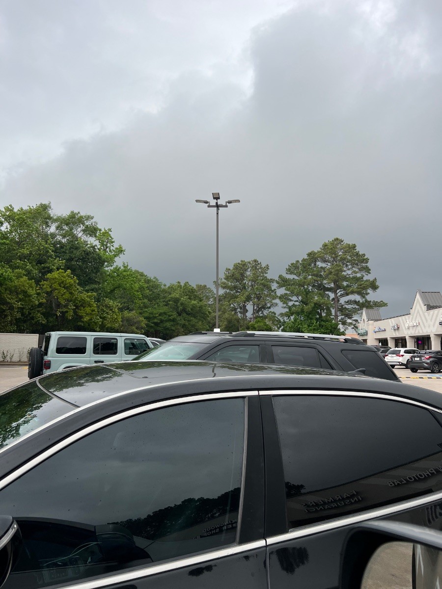
. Dang it video didn't post 😡
This discussion has been locked.
« Back to ChatViews: 1,983
# Replies: 19