


Removed By Request.
Removed By Request.

This discussion has been locked.

Joined:
X days ago
# Posts:
X,XXX
Contributor Points:
X


Discussion Summary:
2024 Hurricane Forecast: Colorado State University Predicts Extremely Active Season
2024 Hurricane Forecast: Colorado State University Predicts Extremely Active Season
Discussion Insights:
Ask a question about this discussion and an AI bot will try to give an answer.
Ask a question about this discussion and an AI bot will try to give an answer.
Replies:

 StormChaser :
Oh, wow! I am not looking forward to this year's hurricane season. Thank you for the warning!

Official 2024 hurricane forecast 2024 forecast from Colorado State University. 🌀 This is the considered the "official" forecast by the NWS. We can easily get complacent when we go years without a storm but I would strongly suggest you prepare for an active year come late Summer. We are overdue for a hurricane as Ike was the last direct hit (2008; 16 years) and Harvey was 7 years ago. (Not a direct hit) It's not about panic - just be prepared. 👠................ 2024 Atlantic hurricane season could be among most active on record, experts predict Colorado State University (CSU) hurricane researchers have released their initial outlook for the upcoming 2024 hurricane season, which they believe promises to be an extremely active year, courtesy of an impending La Niña. The team is calling for 23 named storms, with 11 that are expected to become hurricanes and five that could reach major hurricane status, with winds of at least 115 mph (Category 3 or higher). Forecasters noted that the 2024 outlook was the highest prediction for named storms that CSU has ever issued. And if the prediction were to be accurate, it would mean the National Hurricane Center (NHC) would use all the names on the 2024 Atlantic storm list and have to resort to a supplemental list of tropical cyclone names - a situation that hasn't happened since 2020. 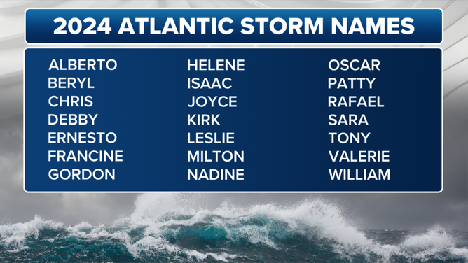 "The Atlantic is still record warm in the tropical Atlantic, providing more fuel for storms," Dr. Phil Klotzbach, a senior research scientist at CSU, told FOX Weather. "The El Niño is weakening, likely to transition to a La Niña. That's colder water in the eastern and central tropical Pacific, typically in the more hurricane-favorable upper-level wind patterns in the Atlantic." www.foxweather.com/w eather-news/hurrican e-researchers-releas e-stunning-pred
 BrendaT tipped StormChaser 100 credits for a post in this forum discussion.
Y'all get prepped and stay safe. I read an article yesterday that broke down landfalls by percentages. The Gulf Coast from TX/MX border to the panhandle of FL.had a 42% chance of landfall. Something about the development of La Niña increases chances for storms to go into the Gulf. So Aug-Oct might be a crazy time!
Official 2024 hurricane forecast 2024 forecast from Colorado State University. 🌀 This is the considered the "official" forecast by the NWS. We can easily get complacent when we go years without a storm but I would strongly suggest you prepare for an active year come late Summer. We are overdue for a hurricane as Ike was the last direct hit (2008; 16 years) and Harvey was 7 years ago. (Not a direct hit) It's not about panic - just be prepared. 👠................ 2024 Atlantic hurricane season could be among most active on record, experts predict Colorado State University (CSU) hurricane researchers have released their initial outlook for the upcoming 2024 hurricane season, which they believe promises to be an extremely active year, courtesy of an impending La Niña. The team is calling for 23 named storms, with 11 that are expected to become hurricanes and five that could reach major hurricane status, with winds of at least 115 mph (Category 3 or higher). Forecasters noted that the 2024 outlook was the highest prediction for named storms that CSU has ever issued. And if the prediction were to be accurate, it would mean the National Hurricane Center (NHC) would use all the names on the 2024 Atlantic storm list and have to resort to a supplemental list of tropical cyclone names - a situation that hasn't happened since 2020. "The Atlantic is still record warm in the tropical Atlantic, providing more fuel for storms," Dr. Phil Klotzbach, a senior research scientist at CSU, told FOX Weather. "The El Niño is weakening, likely to transition to a La Niña. That's colder water in the eastern and central tropical Pacific, typically in the more hurricane-favorable upper-level wind patterns in the Atlantic." www.foxweather.com/w eather-news/hurrican e-researchers-releas e-stunning-pred
StormChaser : While this is good for the type of business I'm in,I hope for nothing
Official 2024 hurricane forecast 2024 forecast from Colorado State University. 🌀 This is the considered the "official" forecast by the NWS. We can easily get complacent when we go years without a storm but I would strongly suggest you prepare for an active year come late Summer. We are overdue for a hurricane as Ike was the last direct hit (2008; 16 years) and Harvey was 7 years ago. (Not a direct hit) It's not about panic - just be prepared. 👠................ 2024 Atlantic hurricane season could be among most active on record, experts predict Colorado State University (CSU) hurricane researchers have released their initial outlook for the upcoming 2024 hurricane season, which they believe promises to be an extremely active year, courtesy of an impending La Niña. The team is calling for 23 named storms, with 11 that are expected to become hurricanes and five that could reach major hurricane status, with winds of at least 115 mph (Category 3 or higher). Forecasters noted that the 2024 outlook was the highest prediction for named storms that CSU has ever issued. And if the prediction were to be accurate, it would mean the National Hurricane Center (NHC) would use all the names on the 2024 Atlantic storm list and have to resort to a supplemental list of tropical cyclone names - a situation that hasn't happened since 2020. "The Atlantic is still record warm in the tropical Atlantic, providing more fuel for storms," Dr. Phil Klotzbach, a senior research scientist at CSU, told FOX Weather. "The El Niño is weakening, likely to transition to a La Niña. That's colder water in the eastern and central tropical Pacific, typically in the more hurricane-favorable upper-level wind patterns in the Atlantic." www.foxweather.com/w eather-news/hurrican e-researchers-releas e-stunning-pred
 Ruger5 tipped StormChaser 100 credits for a post in this forum discussion.
Official 2024 hurricane forecast 2024 forecast from Colorado State University. 🌀 This is the considered the "official" forecast by the NWS. We can easily get complacent when we go years without a storm but I would strongly suggest you prepare for an active year come late Summer. We are overdue for a hurricane as Ike was the last direct hit (2008; 16 years) and Harvey was 7 years ago. (Not a direct hit) It's not about panic - just be prepared. 👠................ 2024 Atlantic hurricane season could be among most active on record, experts predict Colorado State University (CSU) hurricane researchers have released their initial outlook for the upcoming 2024 hurricane season, which they believe promises to be an extremely active year, courtesy of an impending La Niña. The team is calling for 23 named storms, with 11 that are expected to become hurricanes and five that could reach major hurricane status, with winds of at least 115 mph (Category 3 or higher). Forecasters noted that the 2024 outlook was the highest prediction for named storms that CSU has ever issued. And if the prediction were to be accurate, it would mean the National Hurricane Center (NHC) would use all the names on the 2024 Atlantic storm list and have to resort to a supplemental list of tropical cyclone names - a situation that hasn't happened since 2020. "The Atlantic is still record warm in the tropical Atlantic, providing more fuel for storms," Dr. Phil Klotzbach, a senior research scientist at CSU, told FOX Weather. "The El Niño is weakening, likely to transition to a La Niña. That's colder water in the eastern and central tropical Pacific, typically in the more hurricane-favorable upper-level wind patterns in the Atlantic." www.foxweather.com/w eather-news/hurrican e-researchers-releas e-stunning-pred
StormChaser : I've read several articles that raise concern for the water temps. This is unchartered territory they say - and that is most concerning given that warm waters are the primary food source of mega storms. Going to be an interesting, busy season.
Ruger5 : Yeah it's not a good scenario. I've been looking at models for months and they continue to show a 2020 type setup. Don't let the quiet summer fool you. The setup shows this to take place in late Aug/early September. After that, all bets are off. It could be a very long September & October for the Gulf coast. This obviously doesn't guarantee we are going to get storm here. SE Texas but the likelihood is higher than many many years in the past.
StormChaser : I remember Alicia and Ike and the mortal fear of a Rita hit ….or was that Katrina? One of them was so close to hitting here but wobbled East at last minute. I remember attempting to evacuate - had to turn around. Thank God we were spared. A mass evacuation from our area would be nearly impossible with the past few years population explosion. It would be a pretty bad scenario. We're over due to be sure BUT I'll pass on one hitting this year. They will be ferocious storms fermenting in power from the hot water out thar. In such an awful economy there will be a number of states who suffer terribly. This discussion has been locked.
« Back to ChatViews: 1,084
# Replies: 9