


Arctic blast (Thurs update Pg 4)
Arctic blast (Thurs update Pg 4)


Joined:
X days ago
# Posts:
X,XXX
Contributor Points:
X
Discussion Summary:
"Upcoming Arctic Blast: Cold Temperatures and Possible Winter Precipitation in Houston Next Week"
"Upcoming Arctic Blast: Cold Temperatures and Possible Winter Precipitation in Houston Next Week"
Discussion Insights:
Ask a question about this discussion and an AI bot will try to give an answer.
Ask a question about this discussion and an AI bot will try to give an answer.
Replies:


buffaloglenn : They need to give me one to review.
 ZMAN : You could give it the Dwight baby stroller test!
Dang...gonna have a high gas bill and then...a higher than normal electric bill.
 cbear : My heater keeps running now so I can imagine that when the mail delivers my next electric and natural gas bill, it will be a Wells Fargo truck demanding payment.

|
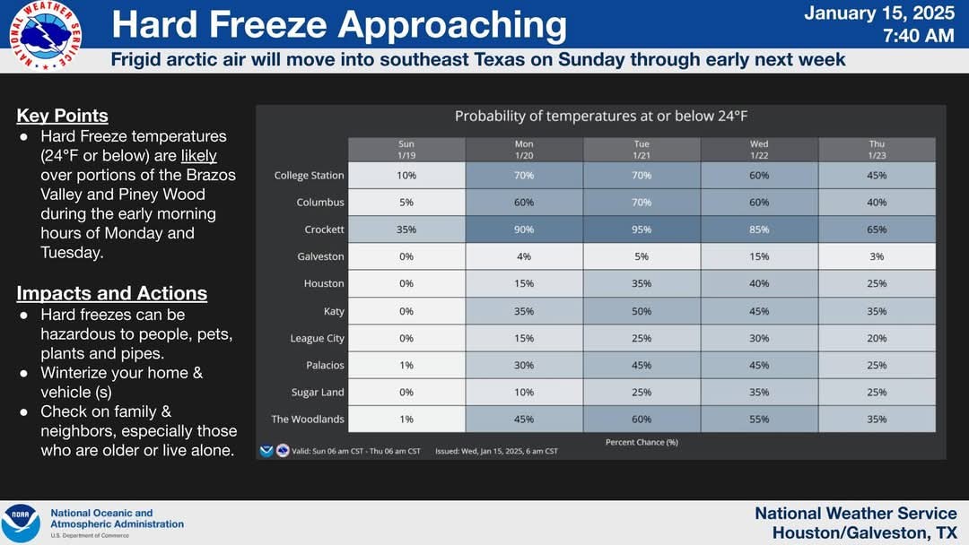
Latest update on upcoming winter weather next week: ❄️ Hard Freeze across SE Texas with incoming front on Saturday afternoon. ❄️ Increasing chance of winter precipitation or ICE. ❄️🌨️🥶 Ice looks like it could be our greatest threat, which would NOT be good as our city comes to a hault with 🧊🧊🧊 ❄️ It's still too early to say what type of wintery precip (snow, sleet, ice) how much we could get or what area has the best chances. ❄️ We'll get a better idea on what will occur by the weekend. ❄️ If we do see snow/sleet/ice, its looking more and more likely that it would occur anytime Tuesday or Wednesday. 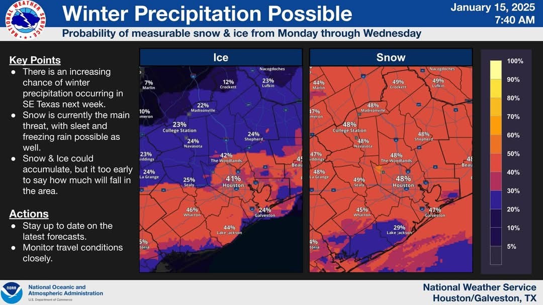
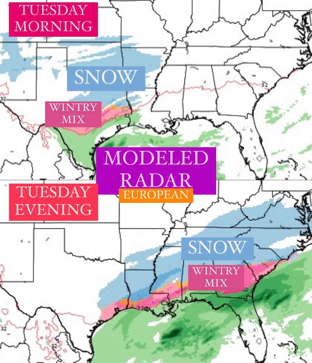 Here is what Space City has to say about it: Here's the reality from a forecaster's standpoint. *Yes, there is an increasing possibility of snow or sleet beginning next Monday night and Tuesday, but this is still nearly six days away. This means our confidence in forecasting any wintry precipitation remains very low.
*There is probably about a 50-50 chance we see some kind of wintry mix, so set your expectations accordingly. Our confidence in the forecast will increase as we get closer. 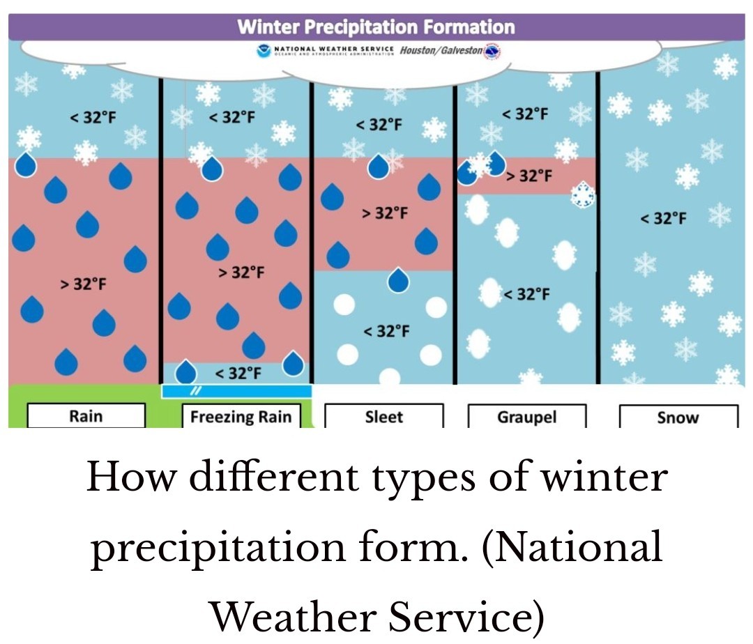 SATURDAY *This will be a partly sunny day, with highs in the low 60s ahead of a strong cold front.
*A few showers and thunderstorms may be possible just ahead of the front as it moves through, but for many people this could be a dry passage.
*I expect the front to reach central Houston by around noon, and push off the coast shortly afterward.
*We may hold on to temperatures in the 50s for a few hours after the front passes, but as the sun sets and northwesterly winds blow, much drier and colder air will be pushing in.
*Lows on Saturday night will drop into the 30s. SUNDAY ❗ You read that right, marathon runners. 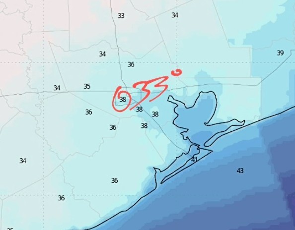 *I now expect start-line temperatures in Houston to be in the vicinity of the mid-30s.
*We don't need to worry about precipitation, fortunately, and skies should be mostly clear.
*What I'm watching mostly closely is winds. Right now they're likely to be out of the north at 10 to 15 mph. The trend in gusts has been slightly lower, so for now I'd anticipate gusting up to about 25 mph. That is certainly no picnic, but it beats 30 or 35 mph.
*The bottom line is that if you're running, I recommend bundling up. I'll be wearing my warmer gloves for this one.
*Highs on Sunday will reach the mid- to upper-40s most likely before a possible freeze on Sunday night. 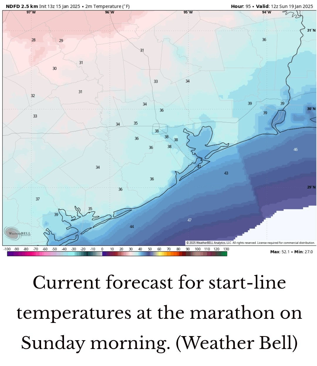 MONDAY *The forecast models have, in recent runs, backed off some of the extreme cold anticipated for next week.
*The caveat at the beginning of this post about snow uncertainty still applies to temperatures as well.
*At this point I would expect most of Houston to experience a light freeze on Monday morning, with partly sunny skies.
*Highs will only reach 40 degrees so if you're participating or watching a parade, please dress warmly. THE REST OF THE WEEK: ❄️ Beginning Monday evening, through Wednesday morning is when the Houston region will experience the best chance of a wintry mix and coldest temperatures. 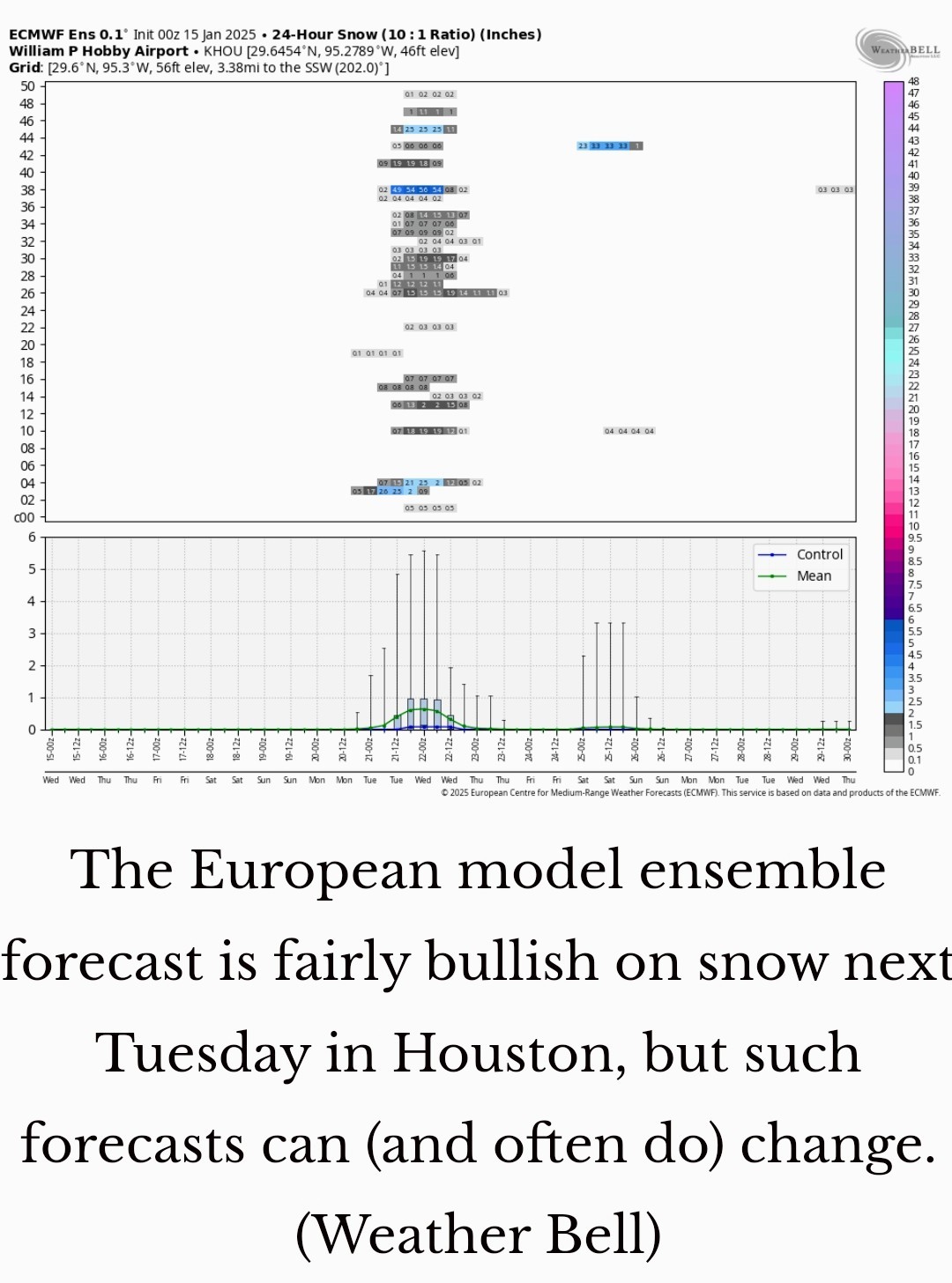 ❄️ We'll start with temperatures: At this point, I think we'll probably bottom out on Tuesday and Wednesday mornings.
❄️ For Houston, the likely range of temperatures on these mornings is probably 25 to 30 degrees, with a hard freeze possible for inland areas, and the immediate coast possibly remaining just above freezing.
❄️ High temperatures through Wednesday will likely be on the order of 40 degrees. Again we'll have to fine-tune the temperature forecast as we get closer. ❄️ With regard to precipitation, we'll start to see an influx of moisture beginning later on Monday and Monday night, and this will bring a modest chance of precipitation on Monday night, Tuesday, and Tuesday night.
❄️ With the colder air this brings the possibility of snow (most likely at this time), sleet, or freezing rain into the forecast.
❄️ Because slight temperature differences in the atmosphere will determine the type of precipitation, we just cannot make a call on whether it will snow, sleet, or rain in Houston during the first half of next week but it's s A DISTINCT POSSIBILITY.
❄️ Mobility issues possible on Tuesday and Wednesday morning.
❄️ We'll be watching all of this closely over the weekend for you, with regular updates. A warming trend begins Thursday. spacecityweather.com /colder-weather-arri ves-on-sunday-with-t he-possibility-
*There is probably about a 50-50 chance we see some kind of wintry mix, so set your expectations accordingly. Our confidence in the forecast will increase as we get closer.
*A few showers and thunderstorms may be possible just ahead of the front as it moves through, but for many people this could be a dry passage.
*I expect the front to reach central Houston by around noon, and push off the coast shortly afterward.
*We may hold on to temperatures in the 50s for a few hours after the front passes, but as the sun sets and northwesterly winds blow, much drier and colder air will be pushing in.
*Lows on Saturday night will drop into the 30s.
*We don't need to worry about precipitation, fortunately, and skies should be mostly clear.
*What I'm watching mostly closely is winds. Right now they're likely to be out of the north at 10 to 15 mph. The trend in gusts has been slightly lower, so for now I'd anticipate gusting up to about 25 mph. That is certainly no picnic, but it beats 30 or 35 mph.
*The bottom line is that if you're running, I recommend bundling up. I'll be wearing my warmer gloves for this one.
*Highs on Sunday will reach the mid- to upper-40s most likely before a possible freeze on Sunday night.
*The caveat at the beginning of this post about snow uncertainty still applies to temperatures as well.
*At this point I would expect most of Houston to experience a light freeze on Monday morning, with partly sunny skies.
*Highs will only reach 40 degrees so if you're participating or watching a parade, please dress warmly.
❄️ For Houston, the likely range of temperatures on these mornings is probably 25 to 30 degrees, with a hard freeze possible for inland areas, and the immediate coast possibly remaining just above freezing.
❄️ High temperatures through Wednesday will likely be on the order of 40 degrees.
❄️ With the colder air this brings the possibility of snow (most likely at this time), sleet, or freezing rain into the forecast.
❄️ Because slight temperature differences in the atmosphere will determine the type of precipitation, we just cannot make a call on whether it will snow, sleet, or rain in Houston during the first half of next week but it's s A DISTINCT POSSIBILITY.
❄️ Mobility issues possible on Tuesday and Wednesday morning.
❄️ We'll be watching all of this closely over the weekend for you, with regular updates.
|
|

Latest update on upcoming winter weather next week: ❄️ Hard Freeze across SE Texas with incoming front on Saturday afternoon. ❄️ Increasing chance of winter precipitation or ICE. ❄️🌨️🥶 Ice looks like it could be our greatest threat, which would NOT be good as our city comes to a hault with 🧊🧊🧊 ❄️ It's still too early to say what type of wintery precip (snow, sleet, ice) how much we could get or what area has the best chances. ❄️ We'll get a better idea on what will occur by the weekend. ❄️ If we do see snow/sleet/ice, its looking more and more likely that it would occur anytime Tuesday or Wednesday. Here is what Space City has to say about it: Here's the reality from a forecaster's standpoint. *Yes, there is an increasing possibility of snow or sleet beginning next Monday night and Tuesday, but this is still nearly six days away. This means our confidence in forecasting any wintry precipitation remains very low. *There is probably about a 50-50 chance we see some kind of wintry mix, so set your expectations accordingly. Our confidence in the forecast will increase as we get closer. SATURDAY *This will be a partly sunny day, with highs in the low 60s ahead of a strong cold front. *A few showers and thunderstorms may be possible just ahead of the front as it moves through, but for many people this could be a dry passage. *I expect the front to reach central Houston by around noon, and push off the coast shortly afterward. *We may hold on to temperatures in the 50s for a few hours after the front passes, but as the sun sets and northwesterly winds blow, much drier and colder air will be pushing in. *Lows on Saturday night will drop into the 30s. SUNDAY ❗ You read that right, marathon runners. *I now expect start-line temperatures in Houston to be in the vicinity of the mid-30s. *We don't need to worry about precipitation, fortunately, and skies should be mostly clear. *What I'm watching mostly closely is winds. Right now they're likely to be out of the north at 10 to 15 mph. The trend in gusts has been slightly lower, so for now I'd anticipate gusting up to about 25 mph. That is certainly no picnic, but it beats 30 or 35 mph. *The bottom line is that if you're running, I recommend bundling up. I'll be wearing my warmer gloves for this one. *Highs on Sunday will reach the mid- to upper-40s most likely before a possible freeze on Sunday night. MONDAY *The forecast models have, in recent runs, backed off some of the extreme cold anticipated for next week. *The caveat at the beginning of this post about snow uncertainty still applies to temperatures as well. *At this point I would expect most of Houston to experience a light freeze on Monday morning, with partly sunny skies. *Highs will only reach 40 degrees so if you're participating or watching a parade, please dress warmly. THE REST OF THE WEEK: ❄️ Beginning Monday evening, through Wednesday morning is when the Houston region will experience the best chance of a wintry mix and coldest temperatures. ❄️ We'll start with temperatures: At this point, I think we'll probably bottom out on Tuesday and Wednesday mornings. ❄️ For Houston, the likely range of temperatures on these mornings is probably 25 to 30 degrees, with a hard freeze possible for inland areas, and the immediate coast possibly remaining just above freezing. ❄️ High temperatures through Wednesday will likely be on the order of 40 degrees. Again we'll have to fine-tune the temperature forecast as we get closer. ❄️ With regard to precipitation, we'll start to see an influx of moisture beginning later on Monday and Monday night, and this will bring a modest chance of precipitation on Monday night, Tuesday, and Tuesday night. ❄️ With the colder air this brings the possibility of snow (most likely at this time), sleet, or freezing rain into the forecast. ❄️ Because slight temperature differences in the atmosphere will determine the type of precipitation, we just cannot make a call on whether it will snow, sleet, or rain in Houston during the first half of next week but it's s A DISTINCT POSSIBILITY. ❄️ Mobility issues possible on Tuesday and Wednesday morning. ❄️ We'll be watching all of this closely over the weekend for you, with regular updates. A warming trend begins Thursday. spacecityweather.com /colder-weather-arri ves-on-sunday-with-t he-possibility-
 StormChaser : I have been using Space City the last few years, especially during hurricane season. Love them!
|
|
cbear : My heater keeps running now so I can imagine that when the mail delivers my next electric and natural gas bill, it will be a Wells Fargo truck demanding payment.
Gigix4 : Funny you!!!!!
|
|
cbear : Maybe look into a heated toilet seat! Self-cleaning, too! www.wayfair.com/home -improvement/pdp/ray s-smart-heated-bidet -toilet-seat-wi
 buffaloglenn : I think I will have to make my "prefered toilet" the half bath which is in the center of the house until this passes! LOL!
|
|
cbear : No kidding about the seat being cold. Sometimes it seems so cold, it almost makes you forget why you sat down on it in the first place! LOL
Gigix4 : Oh I don't forget but..... I don't linger either! LOL! My dad always did that. Went to the bathroom, took the paper....didn't see him for 30 minutes!
|
|
yankeejessica : Oh I hope you are ok !
cbear : I'll just keep it running for a day or 2. I'm sure it'll be just fine fingers crossed 🤞🏻
ZMAN : Okay, I just stayed at a really nice hotel, and they had a Toto Toilet; a sought after brand from Japan. It had a heated seat, warm or cool water bidet, a Remote Control, color changing lights under the rim, and had different little tunes that played, for each feature. I did Not want to leave that thing behind...no pun intended!
|
|
cbear : I'll just keep it running for a day or 2. I'm sure it'll be just fine fingers crossed 🤞🏻
 yankeejessica : Me too. I will run it constantly until temps get above freezing.
 « Back to Chat
Views: 3,724
# Replies: 57