


Tropics
Tropics


Joined:
X days ago
# Posts:
X,XXX
Contributor Points:
X


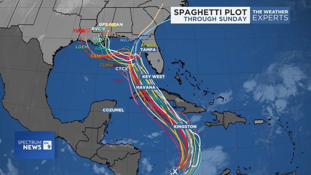
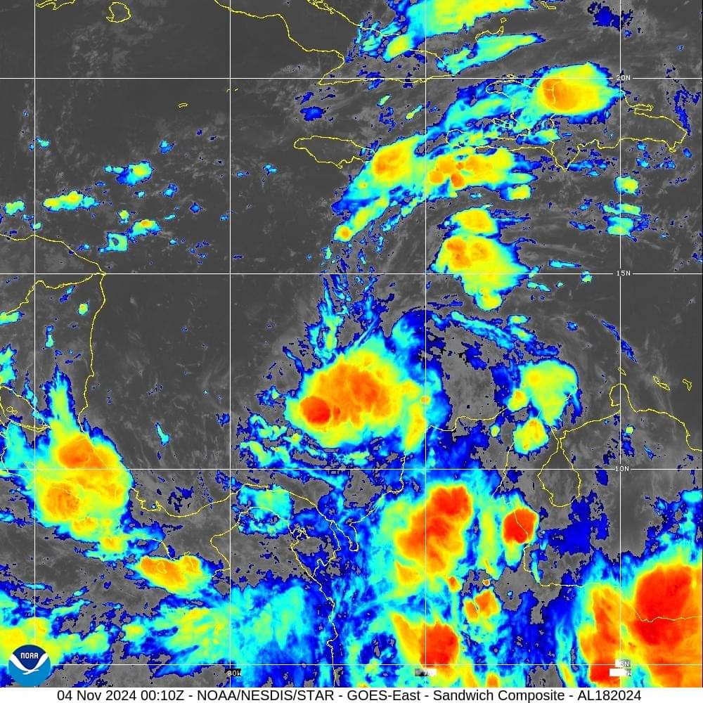
Tropics If anything, a good reminder that hurricane season is not over until November 30th. Key Messages for Potential Tropical Cyclone Number Eighteen. 4:00 PM EST Sun November 3, 2024 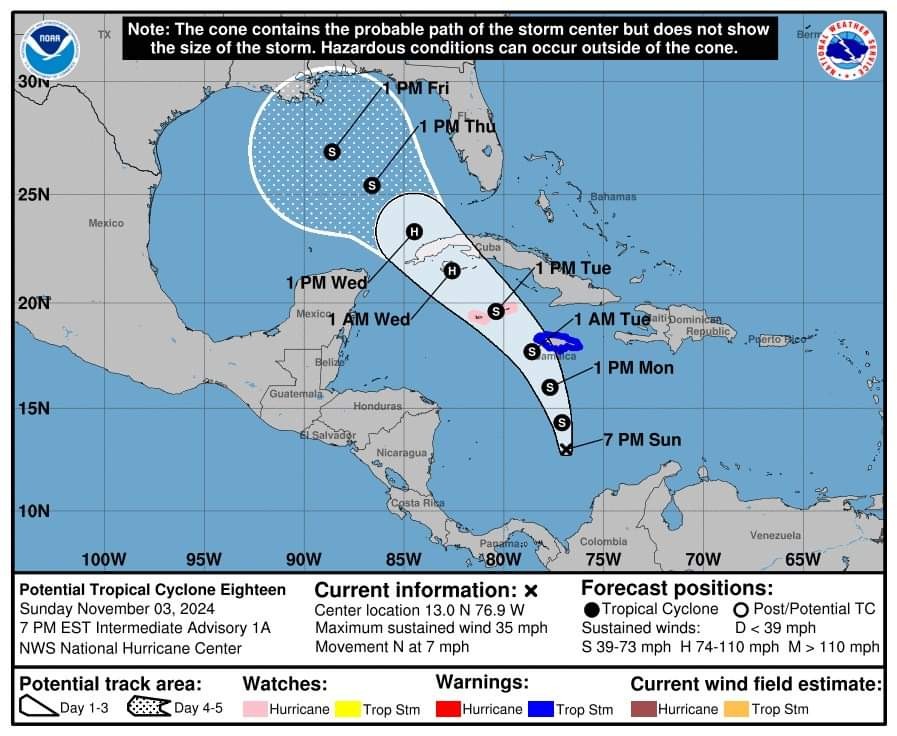 ➡️ Most global model ensemble members show a weak tropical storm, mostly a rainmaker, in the central Gulf of Mexico in 5-7 days with a position anywhere from the Central Gulf Coast (NOLA) to the coast of Mexico. ➡️ It is simply too early to know the track or intensity, but for now we are NOT expecting this to become a hurricane based on the forecast upper air pattern and the ocean heat content. ➡️ Best possible case for the Deep South is a system that brings beneficial rain in 6-7 days, but that is just one of many possibilities.
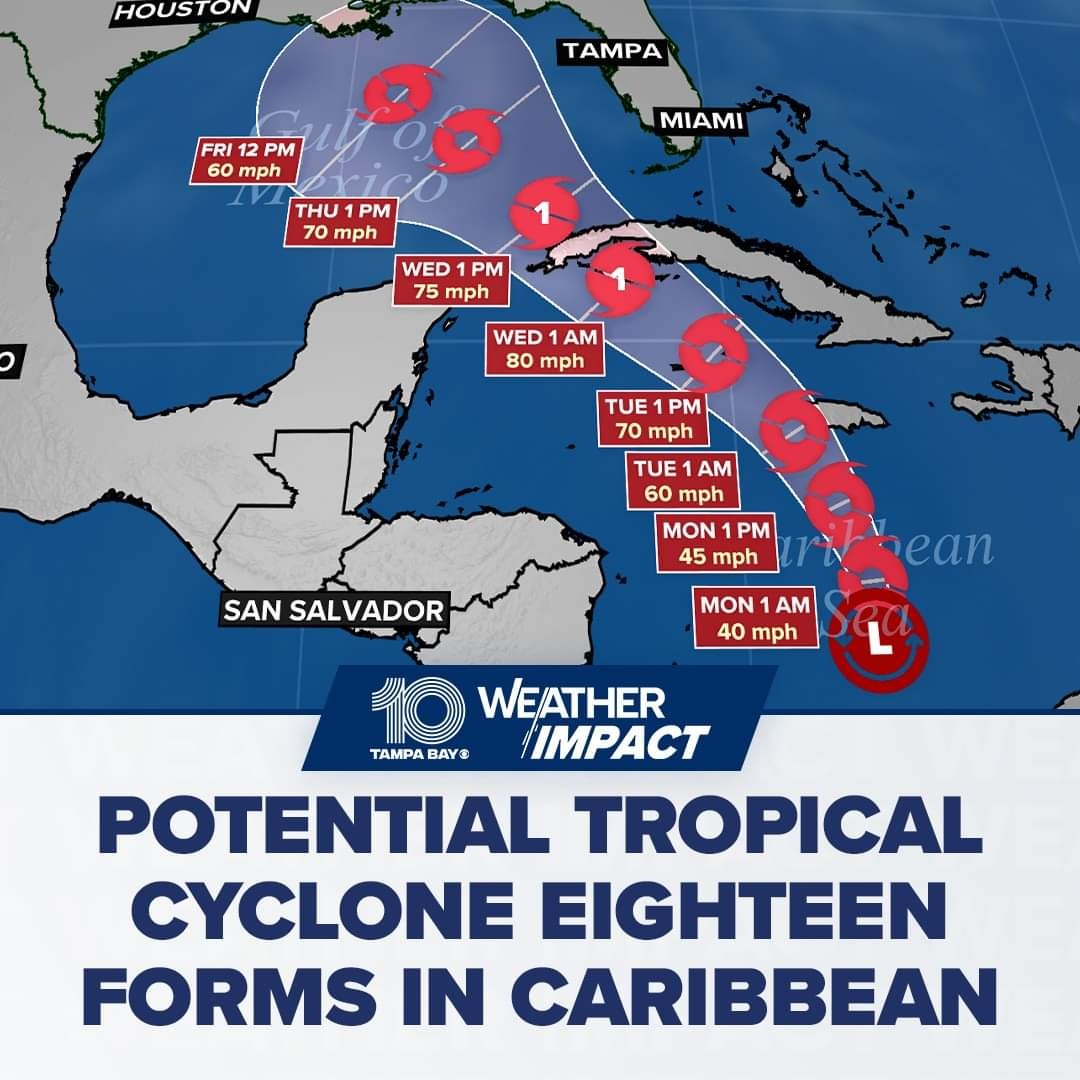
  ➡️ The disturbance is expected to become a tropical storm Monday and pass near Jamaica on Monday night and Tuesday where a Tropical Storm Warning is now in effect. The system is forecast to become a hurricane by Tuesday night and there is a risk of dangerous impacts from hurricane-force winds and storm surge in the Cayman Islands and portions of Cuba. ➡️ Interests in the Florida Keys should closely monitor this system as tropical storm watches could be required for portions of the Florida Keys tonight or early Monday. ➡️ The system is forecast to approach the northern Gulf Coast as a tropical storm later this week, but given uncertainties in the long-range forecast, it is too soon to determine what, if any, impacts could occur. Residents in this area should regularly monitor updates to the forecast. ➡️ The system will bring areas of heavy rain across portions of the western Caribbean, including Jamaica and the southern and western portions of Cuba through mid-week. Flooding could occur over portions of Jamaica and Cuba, with mudslides possible. Heavy rainfall could then spread northward into Florida and adjacent areas of the Southeast United States during the middle to late portions of the week.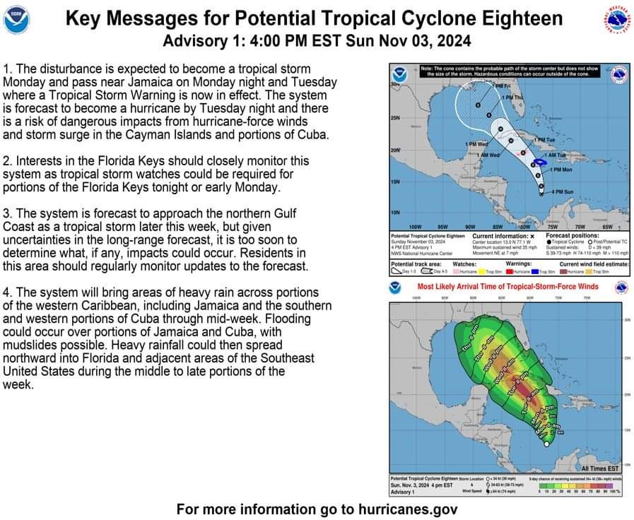


Discussion Summary:
Potential Tropical Cyclone Eighteen: Monitoring Impacts and Uncertainties for the Gulf Coast and Caribbean
Potential Tropical Cyclone Eighteen: Monitoring Impacts and Uncertainties for the Gulf Coast and Caribbean
Discussion Insights:
Ask a question about this discussion and an AI bot will try to give an answer.
Ask a question about this discussion and an AI bot will try to give an answer.
Replies:

 StormChaser :
 Thank you! It is good see your report. It's highly unlikely we will get a hurricane this month however we can not afford to be lackadaisical. Anything is possible.

|
StormChaser : Doing my best to prepare a senior for this rain and wind event. Will pick up more preparedness supplies today.
|
|

Tropics If anything, a good reminder that hurricane season is not over until November 30th. Key Messages for Potential Tropical Cyclone Number Eighteen. 4:00 PM EST Sun November 3, 2024 ➡️ Most global model ensemble members show a weak tropical storm, mostly a rainmaker, in the central Gulf of Mexico in 5-7 days with a position anywhere from the Central Gulf Coast (NOLA) to the coast of Mexico. ➡️ It is simply too early to know the track or intensity, but for now we are NOT expecting this to become a hurricane based on the forecast upper air pattern and the ocean heat content. ➡️ Best possible case for the Deep South is a system that brings beneficial rain in 6-7 days, but that is just one of many possibilities. ➡️ The disturbance is expected to become a tropical storm Monday and pass near Jamaica on Monday night and Tuesday where a Tropical Storm Warning is now in effect. The system is forecast to become a hurricane by Tuesday night and there is a risk of dangerous impacts from hurricane-force winds and storm surge in the Cayman Islands and portions of Cuba. ➡️ Interests in the Florida Keys should closely monitor this system as tropical storm watches could be required for portions of the Florida Keys tonight or early Monday. ➡️ The system is forecast to approach the northern Gulf Coast as a tropical storm later this week, but given uncertainties in the long-range forecast, it is too soon to determine what, if any, impacts could occur. Residents in this area should regularly monitor updates to the forecast. ➡️ The system will bring areas of heavy rain across portions of the western Caribbean, including Jamaica and the southern and western portions of Cuba through mid-week. Flooding could occur over portions of Jamaica and Cuba, with mudslides possible. Heavy rainfall could then spread northward into Florida and adjacent areas of the Southeast United States during the middle to late portions of the week.
StormChaser : Thank you. I have found 2 really good YT channels that have been accurate all Summer. "Mr. Weatherman" with Brian Shields and "Weatherman Plus" with someone named Mark. So many of the storms this year made landfall. Hope 2025 is quiet. Thanks again for all you do for KDC friend!
Tropics If anything, a good reminder that hurricane season is not over until November 30th. Key Messages for Potential Tropical Cyclone Number Eighteen. 4:00 PM EST Sun November 3, 2024 ➡️ Most global model ensemble members show a weak tropical storm, mostly a rainmaker, in the central Gulf of Mexico in 5-7 days with a position anywhere from the Central Gulf Coast (NOLA) to the coast of Mexico. ➡️ It is simply too early to know the track or intensity, but for now we are NOT expecting this to become a hurricane based on the forecast upper air pattern and the ocean heat content. ➡️ Best possible case for the Deep South is a system that brings beneficial rain in 6-7 days, but that is just one of many possibilities. ➡️ The disturbance is expected to become a tropical storm Monday and pass near Jamaica on Monday night and Tuesday where a Tropical Storm Warning is now in effect. The system is forecast to become a hurricane by Tuesday night and there is a risk of dangerous impacts from hurricane-force winds and storm surge in the Cayman Islands and portions of Cuba. ➡️ Interests in the Florida Keys should closely monitor this system as tropical storm watches could be required for portions of the Florida Keys tonight or early Monday. ➡️ The system is forecast to approach the northern Gulf Coast as a tropical storm later this week, but given uncertainties in the long-range forecast, it is too soon to determine what, if any, impacts could occur. Residents in this area should regularly monitor updates to the forecast. ➡️ The system will bring areas of heavy rain across portions of the western Caribbean, including Jamaica and the southern and western portions of Cuba through mid-week. Flooding could occur over portions of Jamaica and Cuba, with mudslides possible. Heavy rainfall could then spread northward into Florida and adjacent areas of the Southeast United States during the middle to late portions of the week.
StormChaser : Hopefully, it will be nothing, just rain.
Tropics If anything, a good reminder that hurricane season is not over until November 30th. Key Messages for Potential Tropical Cyclone Number Eighteen. 4:00 PM EST Sun November 3, 2024 ➡️ Most global model ensemble members show a weak tropical storm, mostly a rainmaker, in the central Gulf of Mexico in 5-7 days with a position anywhere from the Central Gulf Coast (NOLA) to the coast of Mexico. ➡️ It is simply too early to know the track or intensity, but for now we are NOT expecting this to become a hurricane based on the forecast upper air pattern and the ocean heat content. ➡️ Best possible case for the Deep South is a system that brings beneficial rain in 6-7 days, but that is just one of many possibilities. ➡️ The disturbance is expected to become a tropical storm Monday and pass near Jamaica on Monday night and Tuesday where a Tropical Storm Warning is now in effect. The system is forecast to become a hurricane by Tuesday night and there is a risk of dangerous impacts from hurricane-force winds and storm surge in the Cayman Islands and portions of Cuba. ➡️ Interests in the Florida Keys should closely monitor this system as tropical storm watches could be required for portions of the Florida Keys tonight or early Monday. ➡️ The system is forecast to approach the northern Gulf Coast as a tropical storm later this week, but given uncertainties in the long-range forecast, it is too soon to determine what, if any, impacts could occur. Residents in this area should regularly monitor updates to the forecast. ➡️ The system will bring areas of heavy rain across portions of the western Caribbean, including Jamaica and the southern and western portions of Cuba through mid-week. Flooding could occur over portions of Jamaica and Cuba, with mudslides possible. Heavy rainfall could then spread northward into Florida and adjacent areas of the Southeast United States during the middle to late portions of the week.
Steppingout tipped StormChaser 100 credits for a post in this forum discussion.
Tropics If anything, a good reminder that hurricane season is not over until November 30th. Key Messages for Potential Tropical Cyclone Number Eighteen. 4:00 PM EST Sun November 3, 2024 ➡️ Most global model ensemble members show a weak tropical storm, mostly a rainmaker, in the central Gulf of Mexico in 5-7 days with a position anywhere from the Central Gulf Coast (NOLA) to the coast of Mexico. ➡️ It is simply too early to know the track or intensity, but for now we are NOT expecting this to become a hurricane based on the forecast upper air pattern and the ocean heat content. ➡️ Best possible case for the Deep South is a system that brings beneficial rain in 6-7 days, but that is just one of many possibilities. ➡️ The disturbance is expected to become a tropical storm Monday and pass near Jamaica on Monday night and Tuesday where a Tropical Storm Warning is now in effect. The system is forecast to become a hurricane by Tuesday night and there is a risk of dangerous impacts from hurricane-force winds and storm surge in the Cayman Islands and portions of Cuba. ➡️ Interests in the Florida Keys should closely monitor this system as tropical storm watches could be required for portions of the Florida Keys tonight or early Monday. ➡️ The system is forecast to approach the northern Gulf Coast as a tropical storm later this week, but given uncertainties in the long-range forecast, it is too soon to determine what, if any, impacts could occur. Residents in this area should regularly monitor updates to the forecast. ➡️ The system will bring areas of heavy rain across portions of the western Caribbean, including Jamaica and the southern and western portions of Cuba through mid-week. Flooding could occur over portions of Jamaica and Cuba, with mudslides possible. Heavy rainfall could then spread northward into Florida and adjacent areas of the Southeast United States during the middle to late portions of the week.
StormChaser : Oh 💩!!! I don't look forward to that at all. And welcome back. !! « Back to Chat
Views: 1,052
# Replies: 11