


Removed By Request.
Removed By Request.

This discussion has been locked.

Joined:
X days ago
# Posts:
X,XXX
Contributor Points:
X


Discussion Summary:
Expectations for Rainfall and Weather Conditions in Space City on Christmas Eve and Christmas Day
Expectations for Rainfall and Weather Conditions in Space City on Christmas Eve and Christmas Day
Discussion Insights:
Ask a question about this discussion and an AI bot will try to give an answer.
Ask a question about this discussion and an AI bot will try to give an answer.
Replies:


Space City update - Sat AM Setting Expectations For Rainfall Later Today, And On Christmas Eve Eric Berger · Saturday, December 23, 2023 SATURDAY *We're not going to see much, if any sunshine today, and the clouds will help corral high temperatures to around 70 degrees. *I also think we'll remain rain free for most of today, with only the potential for some scattered, light showers through the afternoon hours. *However, by late this afternoon or by around sunset, we should see the development of showers and thunderstorms to the south and southwest of Houston, pushing into the metro area. This may put a damper on outdoor activities this evening. *The bulk of this system should move through Houston by the early morning hours of Sunday. *After that? We may see a break until a second round of storms on Sunday. I think this is the most likely scenario for inland areas. *However, areas closer to the coast and south of Interstate 10 may see additional showers and thunderstorms developing through Sunday morning. *Lows tonight will only drop into the low 60s for most. CHRISTMAS EVE 🎄 *As noted above we're going to continue to see the potential for scattered showers on Sunday morning, with the possibility of thunderstorms. *By mid- or late-morning we should see a more organized system-probably a line of showers, but maybe just a congealed mass-move in from the west ahead of the cold front. *These showers will work their way through Houston during the afternoon hours before finally clearing to the east by around sunset, give or take a couple of hours. *I don't anticipate significant flooding, and at this time we're not going to declare a Stage 1 flood alert. However, conditions during the daytime on Sunday will at times be messy, and you'll need to be wary of the potential for thunderstorms. Take care if you're going to be out and about. *Most locations will pick up 1 to 3 inches of rainfall, but there is the potential for isolated areas to see greater totals. *Temperature wise, Christmas Eve will feel fairly muggy, with highs around 70 degrees. Lows, in the wake of the front, will drop into the 50s overnight. CHRISTMAS DAY 🎅 *Christmas Day, itself, brings no concerns about severe weather. *We're going to see mostly sunny skies, with highs perhaps holding in the upper 50s. With a northerly breeze it will feel rather brisk. *Lows on Christmas night will fall down to around 40 in Houston, with cooler conditions for inland areas.

 StormChaser : Oh my gosh what a delightful Christmas Day forecast!
Space City update - Sat AM Setting Expectations For Rainfall Later Today, And On Christmas Eve Eric Berger · Saturday, December 23, 2023 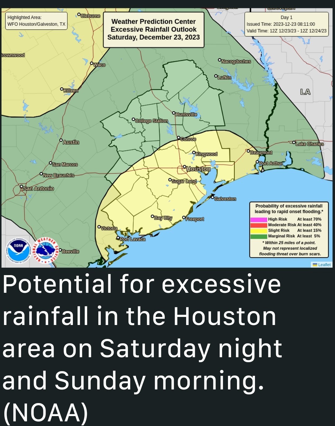 SATURDAY *We're not going to see much, if any sunshine today, and the clouds will help corral high temperatures to around 70 degrees.
*I also think we'll remain rain free for most of today, with only the potential for some scattered, light showers through the afternoon hours.
*However, by late this afternoon or by around sunset, we should see the development of showers and thunderstorms to the south and southwest of Houston, pushing into the metro area. This may put a damper on outdoor activities this evening.
*The bulk of this system should move through Houston by the early morning hours of Sunday. *After that? We may see a break until a second round of storms on Sunday. I think this is the most likely scenario for inland areas. *However, areas closer to the coast and south of Interstate 10 may see additional showers and thunderstorms developing through Sunday morning.
*Lows tonight will only drop into the low 60s for most. CHRISTMAS EVE 🎄 *As noted above we're going to continue to see the potential for scattered showers on Sunday morning, with the possibility of thunderstorms.
*By mid- or late-morning we should see a more organized system-probably a line of showers, but maybe just a congealed mass-move in from the west ahead of the cold front. *These showers will work their way through Houston during the afternoon hours before finally clearing to the east by around sunset, give or take a couple of hours.
*I don't anticipate significant flooding, and at this time we're not going to declare a Stage 1 flood alert. However, conditions during the daytime on Sunday will at times be messy, and you'll need to be wary of the potential for thunderstorms. Take care if you're going to be out and about. *Most locations will pick up 1 to 3 inches of rainfall, but there is the potential for isolated areas to see greater totals. *Temperature wise, Christmas Eve will feel fairly muggy, with highs around 70 degrees. Lows, in the wake of the front, will drop into the 50s overnight. CHRISTMAS DAY 🎅 *Christmas Day, itself, brings no concerns about severe weather. *We're going to see mostly sunny skies, with highs perhaps holding in the upper 50s. With a northerly breeze it will feel rather brisk. *Lows on Christmas night will fall down to around 40 in Houston, with cooler conditions for inland areas.
*I also think we'll remain rain free for most of today, with only the potential for some scattered, light showers through the afternoon hours.
*However, by late this afternoon or by around sunset, we should see the development of showers and thunderstorms to the south and southwest of Houston, pushing into the metro area. This may put a damper on outdoor activities this evening.
*The bulk of this system should move through Houston by the early morning hours of Sunday.
*Lows tonight will only drop into the low 60s for most.
*By mid- or late-morning we should see a more organized system-probably a line of showers, but maybe just a congealed mass-move in from the west ahead of the cold front. *These showers will work their way through Houston during the afternoon hours before finally clearing to the east by around sunset, give or take a couple of hours.
*I don't anticipate significant flooding, and at this time we're not going to declare a Stage 1 flood alert. However, conditions during the daytime on Sunday will at times be messy, and you'll need to be wary of the potential for thunderstorms.
@NullAmpersand tipped
StormChaser 100 credits for a post in this forum discussion. This discussion has been locked.
« Back to ChatViews: 710
# Replies: 10