


This week's forecast
This week's forecast


Joined:
X days ago
# Posts:
X,XXX
Contributor Points:
X


This week's forecast From Space City Weather : Houston records its first night in the 40s this fall, and tonight will be even colder. Eric Berger · Monday, November 16, 2026 7:04 AM 👉In brief: *It's a new week, and we're starting it off with our coldest weather of the season.
*Houston dipped into the 40s for the first time this season, and we discuss how late that is.
*Also, we should get even colder tonight, followed by a pleasant fall week. 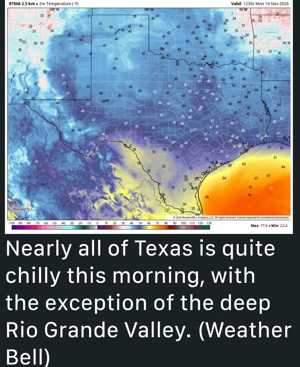 👉Lordy, lordy, we're finally in the forties - *I ran the numbers this morning to find out if we're late for this kind of cold weather, and it turns out yes, we are.
*On average, Houston records its first sub-50 degree night on October 21, so more than three weeks ago.
*The latest ever mark for the first fall night in the 40s came back in 1958, on November 19.
*So we're going to scrape under that record, if only barely. 👉MONDAY - *The low temperature at Bush Intercontinental Airport this morning is 49 degrees, and we may tick a degree lower before we start rising.
*Overall it should be a chilly day, highs rising to only around 60 degrees, or slightly higher, with cloudy skies becoming at least partly sunny this afternoon.
*North-northeast winds gusting to 15 to 20 mph will add to the chill in the air.
*The rains are over, however, probably at least until the weekend.
*With clearing skies we should see lows tonight fall a couple of degrees lower, so some inland locations will fall into the low to mid-40s, whereas urban Houston should stay in the upper 40s. 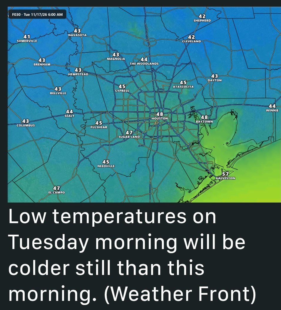 👉TUESDAY - *This will be a splendid, sunny day with highs in the upper 60s and light northeasterly winds.
*Overnight lows will drop into the lower 50s in Houston. 👉WEDNESDAY, THURSDAY, and FRIDAY - *These days will bring mild weather, with partly to sunny skies, thanks to high pressure holding sway.
*Highs on Wednesday will likely be in the the mid-70s, rising to the upper 70s by Friday.
*Nights will see lows in the upper 50s to about 60 degrees in Houston, with cooler conditions for outlying areas, and slightly warmer nights near the coast.
*Rain chances remain near zero. 👉SATURDAY and SUNDAY - *We'll see a mix of sunshine and clouds this weekend, with highs in the vicinity of 75 to 80 degrees.
*Lows will be in the vicinity of 60 degrees, with some humidity.
*The overall pattern is not super clear, but with increasing atmospheric moisture levels we could see some spotty rain showers on Saturday or Sunday.
*However, I'm not ready to make any firm predictions yet. 👉NEXT WEEK - *Then we get to the week of Thanksgiving. I'll do a deeper dive into this in tomorrow's post.
*At some point early next week, perhaps Monday night, perhaps Tuesday, a front will arrive and likely bring some precipitation with it.
*This will bring temperatures down toward more normal levels for the mid and late part of next week.
*By the period of Thanksgiving, I think we'll be somewhere in the range of highs in the 60s and lows in the 50s.
*Again, I'll delve deeper into the data tomorrow to see if there's anything we can confidently forecast.


Jeepinbear, Rocketgirl13 and teatime + 1 more reacted *Houston dipped into the 40s for the first time this season, and we discuss how late that is.
*Also, we should get even colder tonight, followed by a pleasant fall week.
*On average, Houston records its first sub-50 degree night on October 21, so more than three weeks ago.
*The latest ever mark for the first fall night in the 40s came back in 1958, on November 19.
*So we're going to scrape under that record, if only barely.
*Overall it should be a chilly day, highs rising to only around 60 degrees, or slightly higher, with cloudy skies becoming at least partly sunny this afternoon.
*North-northeast winds gusting to 15 to 20 mph will add to the chill in the air.
*The rains are over, however, probably at least until the weekend.
*With clearing skies we should see lows tonight fall a couple of degrees lower, so some inland locations will fall into the low to mid-40s, whereas urban Houston should stay in the upper 40s.
*Overnight lows will drop into the lower 50s in Houston.
*Highs on Wednesday will likely be in the the mid-70s, rising to the upper 70s by Friday.
*Nights will see lows in the upper 50s to about 60 degrees in Houston, with cooler conditions for outlying areas, and slightly warmer nights near the coast.
*Rain chances remain near zero.
*Lows will be in the vicinity of 60 degrees, with some humidity.
*The overall pattern is not super clear, but with increasing atmospheric moisture levels we could see some spotty rain showers on Saturday or Sunday.
*However, I'm not ready to make any firm predictions yet.
*At some point early next week, perhaps Monday night, perhaps Tuesday, a front will arrive and likely bring some precipitation with it.
*This will bring temperatures down toward more normal levels for the mid and late part of next week.
*By the period of Thanksgiving, I think we'll be somewhere in the range of highs in the 60s and lows in the 50s.
*Again, I'll delve deeper into the data tomorrow to see if there's anything we can confidently forecast.
Replies:

 StormChaser :
Maybe Now I can wash my car, and not be a sweaty mess. I love it. Thanks for the great info!
« Back to Chat
Views: 107
# Replies: 2