


Weekend forecast - winter weather update
Weekend forecast - winter weather update


Joined:
X days ago
# Posts:
X,XXX
Contributor Points:
X


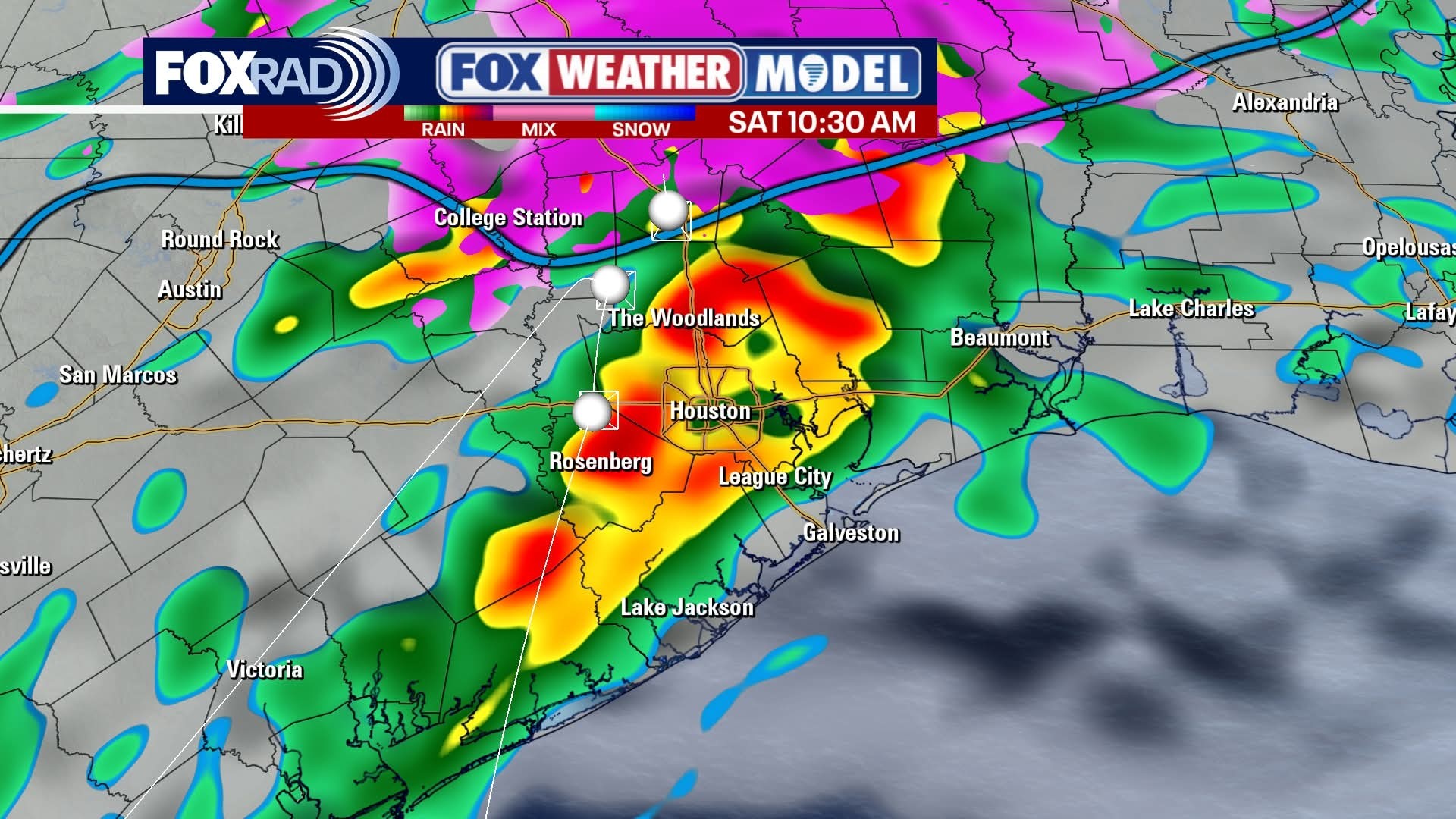
Weekend forecast - winter weather update Lots of info - *The biggest change is that we'll see thunderstorm tomorrow morning with up to 1.5" of rain possible. Temps will be well above freezing at the time, but the roads will be very wet afterwards & the temps will drop into the 20s late Saturday evening. Elevated surfaces will likely have big issues overnight Saturday and all day Sunday.
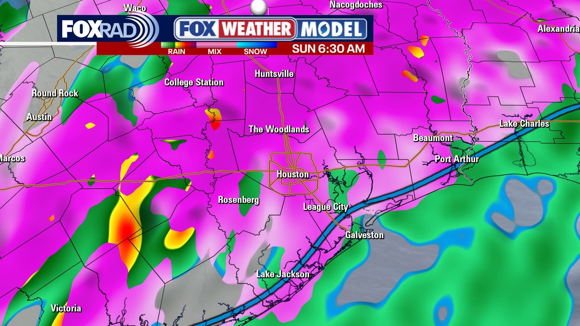
*Sunday still had lots of what ifs but I think we could see a little of everything; even a bit of snow. (NO accumulation likely)
*Monday morning will all be determined by if we get above freezing on Sunday. It's going to be close so we'll see. I wouldn't be surprised if there were issues on the roadways Monday AM.
*We have ANOTHER Arctic front coming next weekend and the models show an increased snow chance in SE Texas, but it's way too early to forecast. We'll see. ❄️ ......... From Space City Weather: The Arctic front is now nearing Texas. Here's the latest on what it means for the greater Houston area. Eric Berger · Friday, January 23, 2026 6:57 AM In brief:
*In today's post we dive into the latest data about the impending winter storm and share our thoughts about freezing rain, hard freezes, and more in Houston.
*There is also a new wrinkle, with the potential for thunderstorms on Saturday morning. Because, why not? 🤦♀️ Winter Storm overview - *We continue to monitor the impacts from an Arctic front that will arrive this weekend in the Houston region.
*Friday and Saturday should be fine for getting around, although in a new wrinkle we now anticipate the potential for some thunderstorms on Saturday morning.
*Fortunately, this will fall just as rain.
*We are still watching closely for when temperatures reach the freezing mark in the metro area, as that will make all the difference as to whether we see freezing rain and icy roads on Sunday morning. See below for a full discussion of all this. FRIDAY - *We are seeing plenty of fog across the area this morning, with light winds, and temperatures and dewpoints both settling at about 60 degrees.
*Highs today will push into the upper 60s, with mostly cloudy skies.
*We could see a few light showers, but these should be nothing to write home about.
*Lows tonight should drop into the 50s, area-wide, as the initial push of colder air arrives from the cold front. Radar pic SATURDAY - *There's a new threat to talk about on Saturday.
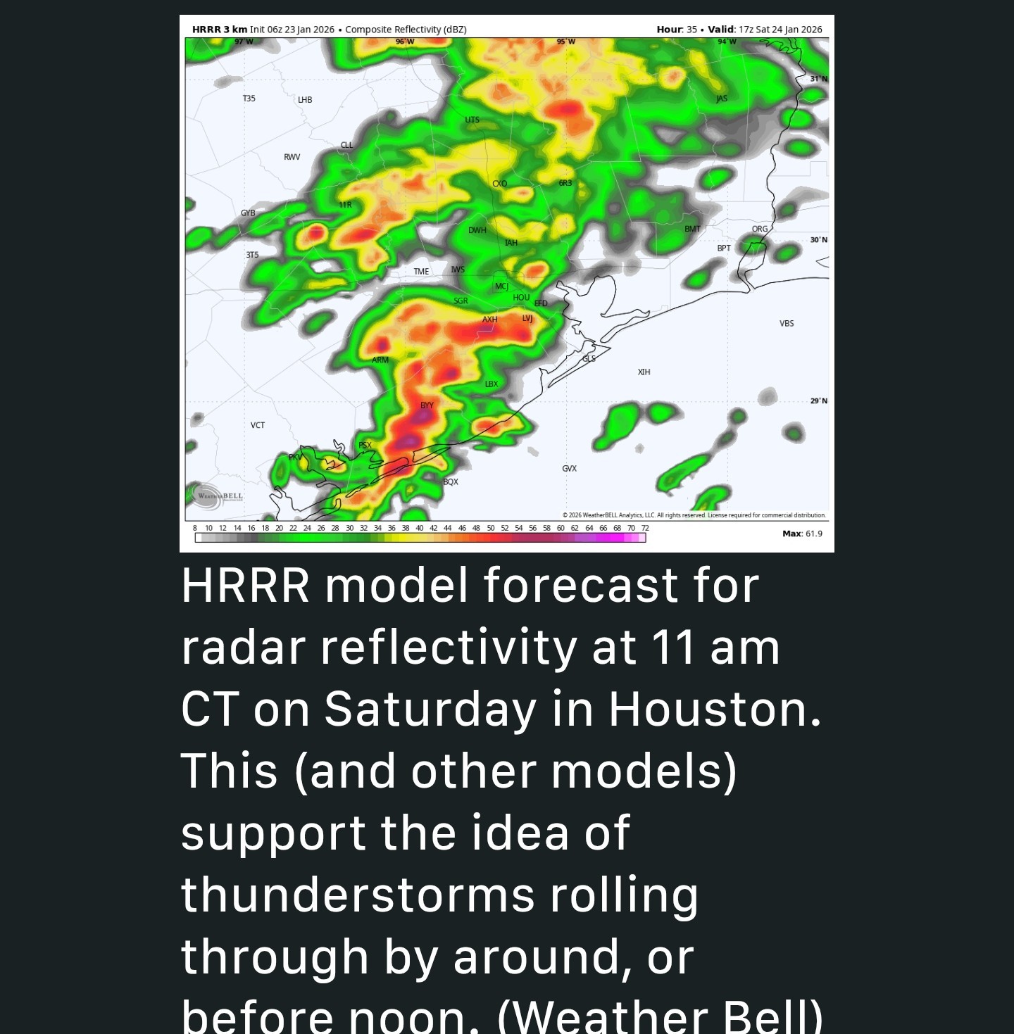
*There will be an interesting setup with very moist, and warm air offshore and much colder air over inland parts of Texas. This could well lead to the development of some thunderstorms during the mid-morning hours on Saturday, as essentially a line of storms pushes through.
*This is likely to drop 0.5 to 1.0 inch of rain pretty quickly, and I hope the city's efforts to treat bridges and overpasses for ice (which may come later) takes this rainfall into account.
*With temperatures likely around 50 degrees in Houston on Saturday, this will indeed just fall as rain.
*After these showers and storms move through, we could see an end to precipitation for awhile on Saturday afternoon, although our skies will remain mostly cloudy.
*Temperatures likely will hover in the 40s during the afternoon hours, with modest northerly winds. At some point on Saturday evening, to Saturday night, freezing temperatures will start to get closer to the area. *They could arrive in Montgomery County by around 9 pm to midnight, and likely not moving into Harris and counties closer to the coast until after midnight or later.
*I expect area roadways to remain passable, at the very least, through Saturday evening. SUNDAY - Ahh, Sunday. This day remains the bane of a forecaster's existence. We really need to know precise temperatures throughout the day, literally to within a degree, and as of yet we still don't have that kind of certainty. *With that said, I expect to see additional light showers overnight on Saturday into Sunday, followed by what may be a second line of showers and thunderstorms around sunrise on Sunday, or shortly thereafter.
*Then, the rain should exit to our east, for good. 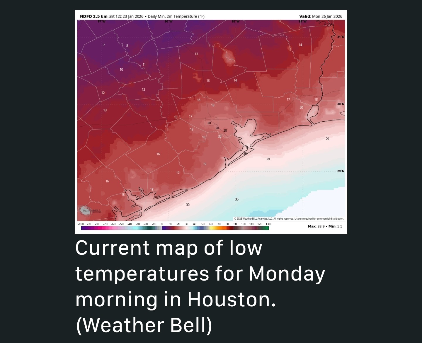 MONDAY - *What roads look like on Monday morning will depend on what they looked like Sunday evening.
*We are not going to see any additional precipitation, so if they're dry on Sunday night, they'll be dry on Monday morning.
*We should see temperatures climb to highs between 35 and 40 degrees on Monday, and with clear skies and light winds, we can expect another very cold night.
*Temperatures likely only be 1 to 3 degrees above conditions on Sunday night. ➡️Question no. 1 is: How cold will temperatures be across the metro area at sunrise on Sunday? If they're below freezing at your location, there's a decent chance of some minor ice accumulation. If they're above freezing at your location, it's just very cold rain. I think there's about a 50 percent chance of freezing temperatures in a location such as The Woodlands at this time, and perhaps less than 50 percent along the I-10 corridor in Houston, and less still south of there. So when you wake up on Sunday, and consider going out and about, you're going to need to be weather aware. Check local temperatures. See if the precipitation has moved on. Read what we're saying here. Roads on Sunday morning may be fine. They may be mostly OK with some issues on elevated surfaces. Or it may be pretty icy out there and you should stay inside. For now our best guess (emphasis on guess) is this: 🧊There could be up to 0.2 inch of ice accumulation in Montgomery County, especially along and north of Highway 105.
🧊Areas of northwest Harris County, as well as Waller and Austin counties, may see some minor ice accumulations.
*Areas closer to the coast probably will not. Pick and white Pic ➡️ Question no. 2 is: How warm will temperatures get on Sunday afternoon? As precipitation exits to the east, we should see some partially clearing skies on Sunday. With gusty northwesterly winds (perhaps up to 25 mph from the north) we are going to see a lot of very cold air advecting in. If temperatures are above freezing in your location for a couple of hours, with a little sunshine and these winds, we are going to see good conditions to dry out roads. However, if temperatures remain at or below freezing at your location, any ice is going to stick around. My general guess is that we are going to see roads dry out, at least in non-shadowed areas. But an alternative possibility is that we don't get enough heat or sunlight before frigid temperatures descend Sunday evening. Again this is going to have to be a game time decision. We remain highly confident in temperatures plunging on Sunday night, probably down to the 20-25 degree range in urban Houston, with conditions a little warmer closer to the coast, and a little cooler in places like Katy and The Woodlands (15 to 25 degrees). Note there still is some uncertainty about how cold it will get. Continued below ⬇️


Wingsofwonder, Mimilane and peppermintstick + 4 more reacted *Sunday still had lots of what ifs but I think we could see a little of everything; even a bit of snow. (NO accumulation likely)
*Monday morning will all be determined by if we get above freezing on Sunday. It's going to be close so we'll see. I wouldn't be surprised if there were issues on the roadways Monday AM.
*We have ANOTHER Arctic front coming next weekend and the models show an increased snow chance in SE Texas, but it's way too early to forecast.
*In today's post we dive into the latest data about the impending winter storm and share our thoughts about freezing rain, hard freezes, and more in Houston.
*There is also a new wrinkle, with the potential for thunderstorms on Saturday morning.
*Friday and Saturday should be fine for getting around, although in a new wrinkle we now anticipate the potential for some thunderstorms on Saturday morning.
*Fortunately, this will fall just as rain.
*We are still watching closely for when temperatures reach the freezing mark in the metro area, as that will make all the difference as to whether we see freezing rain and icy roads on Sunday morning.
*Highs today will push into the upper 60s, with mostly cloudy skies.
*We could see a few light showers, but these should be nothing to write home about.
*Lows tonight should drop into the 50s, area-wide, as the initial push of colder air arrives from the cold front.
*There will be an interesting setup with very moist, and warm air offshore and much colder air over inland parts of Texas. This could well lead to the development of some thunderstorms during the mid-morning hours on Saturday, as essentially a line of storms pushes through.
*This is likely to drop 0.5 to 1.0 inch of rain pretty quickly, and I hope the city's efforts to treat bridges and overpasses for ice (which may come later) takes this rainfall into account.
*With temperatures likely around 50 degrees in Houston on Saturday, this will indeed just fall as rain.
*After these showers and storms move through, we could see an end to precipitation for awhile on Saturday afternoon, although our skies will remain mostly cloudy.
*Temperatures likely will hover in the 40s during the afternoon hours, with modest northerly winds.
*I expect area roadways to remain passable, at the very least, through Saturday evening.
*Then, the rain should exit to our east, for good.
*We are not going to see any additional precipitation, so if they're dry on Sunday night, they'll be dry on Monday morning.
*We should see temperatures climb to highs between 35 and 40 degrees on Monday, and with clear skies and light winds, we can expect another very cold night.
*Temperatures likely only be 1 to 3 degrees above conditions on Sunday night.
🧊Areas of northwest Harris County, as well as Waller and Austin counties, may see some minor ice accumulations.
*Areas closer to the coast probably will not.
Replies:

|
Continued (Sunday info) ➡️Question no. 1 is: How cold will temperatures be across the metro area at sunrise on Sunday? If they're below freezing at your location, there's a decent chance of some minor ice accumulation. If they're above freezing at your location, it's just very cold rain. I think there's about a 50 percent chance of freezing temperatures in a location such as The Woodlands at this time, and perhaps less than 50 percent along the I-10 corridor in Houston, and less still south of there. So when you wake up on Sunday, and consider going out and about, you're going to need to be weather aware. Check local temperatures. See if the precipitation has moved on. Read what we're saying here. Roads on Sunday morning may be fine. They may be mostly OK with some issues on elevated surfaces. Or it may be pretty icy out there and you should stay inside. For now our best guess (emphasis on guess) is this: 🧊There could be up to 0.2 inch of ice accumulation in Montgomery County, especially along and north of Highway 105.
🧊Areas of northwest Harris County, as well as Waller and Austin counties, may see some minor ice accumulations.
*Areas closer to the coast probably will not. 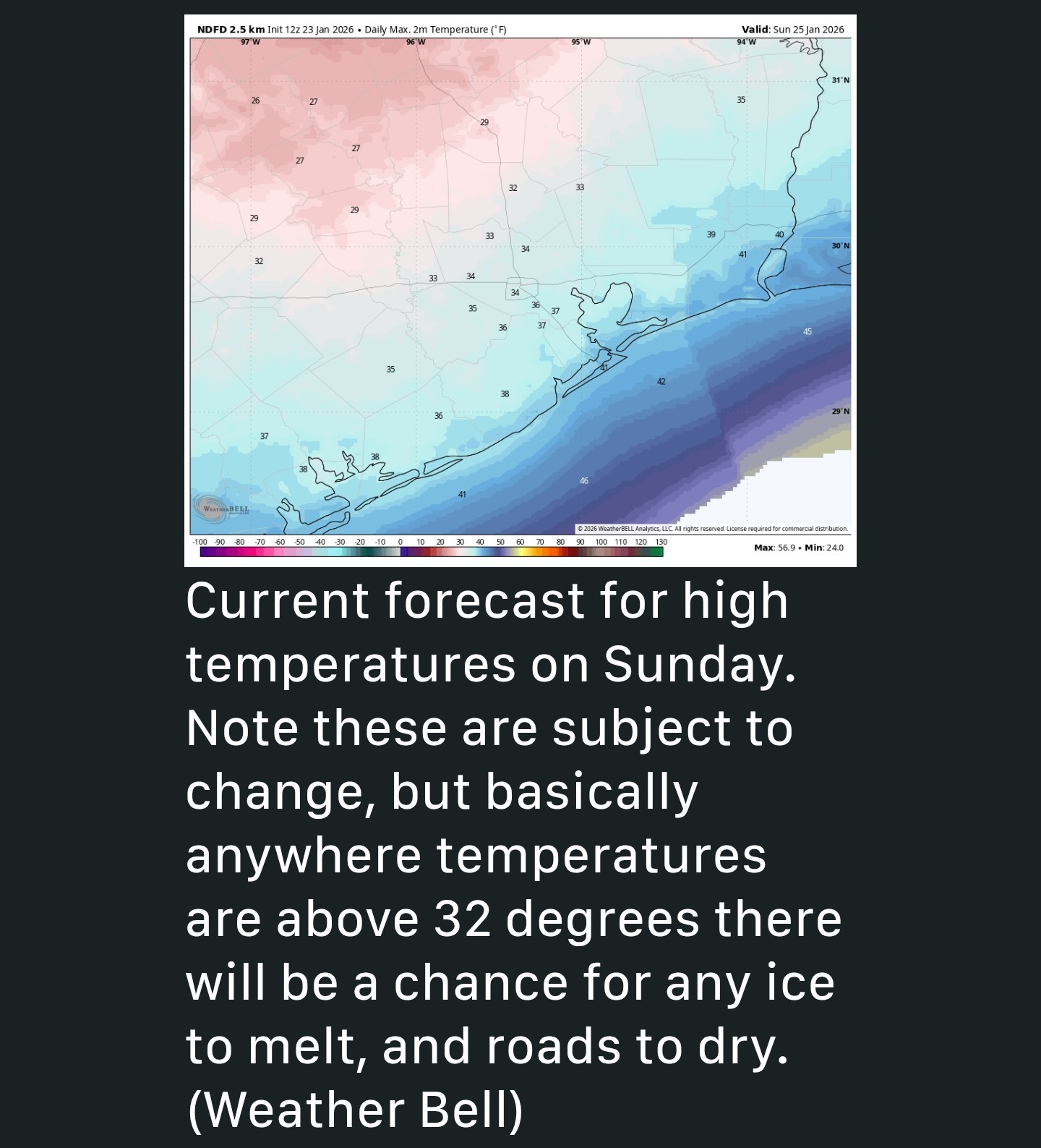 ➡️ Question no. 2 is: How warm will temperatures get on Sunday afternoon? As precipitation exits to the east, we should see some partially clearing skies on Sunday. With gusty northwesterly winds (perhaps up to 25 mph from the north) we are going to see a lot of very cold air advecting in. If temperatures are above freezing in your location for a couple of hours, with a little sunshine and these winds, we are going to see good conditions to dry out roads. However, if temperatures remain at or below freezing at your location, any ice is going to stick around. My general guess is that we are going to see roads dry out, at least in non-shadowed areas. But an alternative possibility is that we don't get enough heat or sunlight before frigid temperatures descend Sunday evening. Again this is going to have to be a game time decision. We remain highly confident in temperatures plunging on Sunday night, probably down to the 20-25 degree range in urban Houston, with conditions a little warmer closer to the coast, and a little cooler in places like Katy and The Woodlands (15 to 25 degrees). Note there still is some uncertainty about how cold it will get.
Texasdaughter, Wingsofwonder and golfshot + 2 more reacted 🧊Areas of northwest Harris County, as well as Waller and Austin counties, may see some minor ice accumulations.
*Areas closer to the coast probably will not.

Oooo I have hot chocolate run next weekend!!! Cold is welcome but not ice!!
Wingsofwonder, peppermintstick and StormChaser reacted
|
|
Oooo I have hot chocolate run next weekend!!! Cold is welcome but not ice!!
Txbutterfly : A few models for next weekend show snow, not ice. 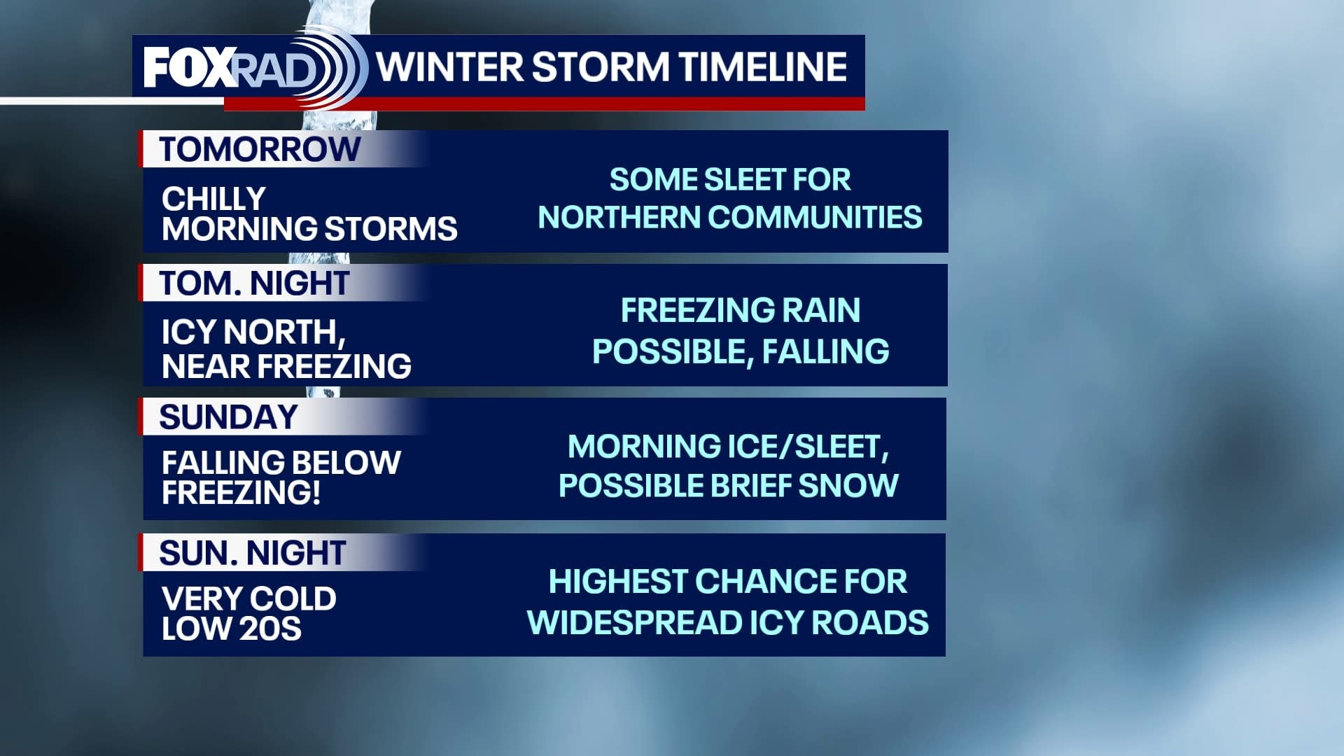
|
|
Oof. 9AM future radar tomorrow morning (Sat) The heaviest rain is supposed to fall south of us but it will be close. We could definitely see some locally heavy amounts. A few strong/severe storms aren't out of the question. This weekends bingo card has just about everything on it. 😆 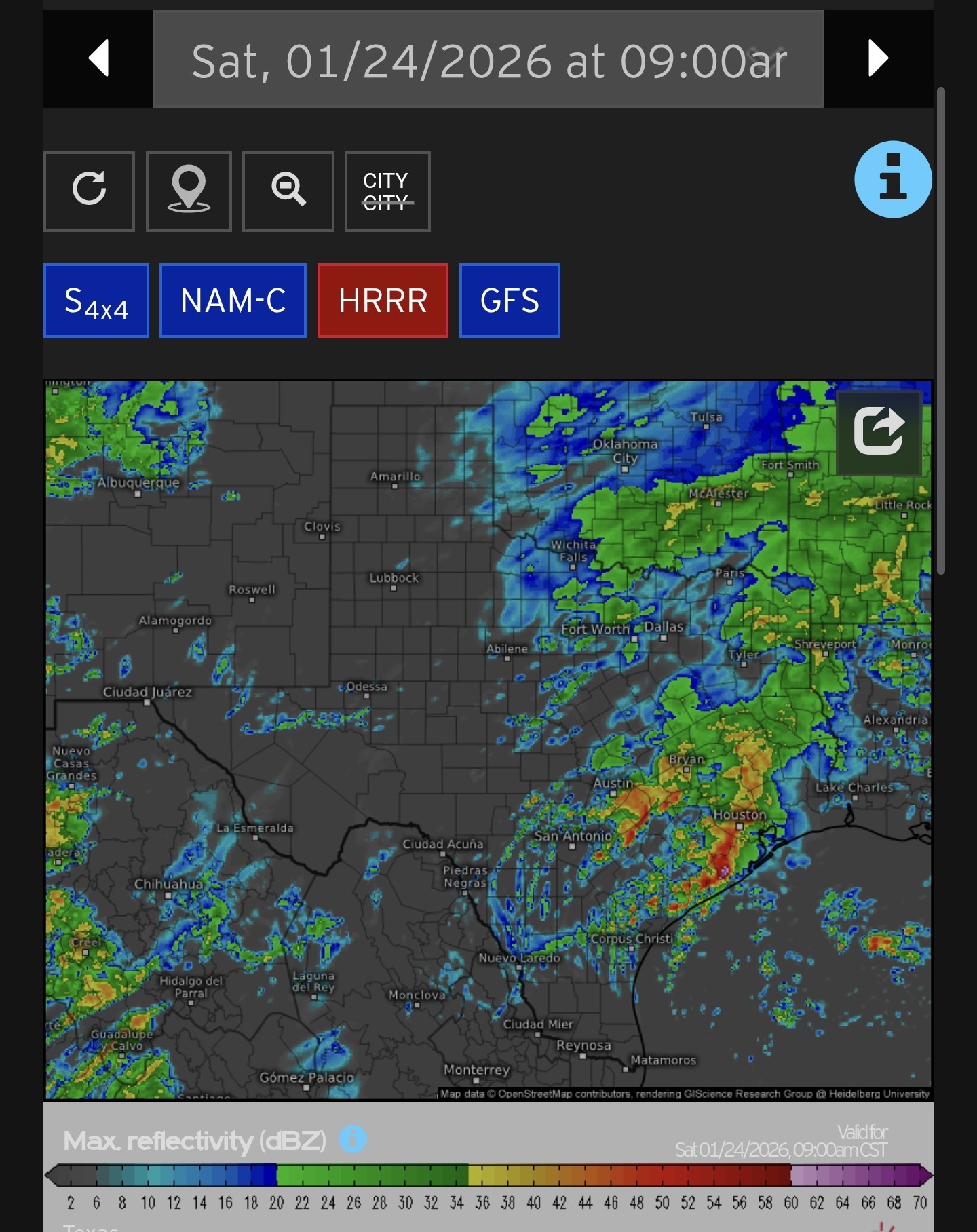
Wingsofwonder and peppermintstick reacted 
|
|
New models are starting to push the freezing rain line a bit more to the southwest. Interesting take on the new data. We'll see if this trend continues. ⬇️ After scrutinizing the latest guidance. its trends, the strength of the arctic air mass, its tendency to move southwestward initially (rather than due south) and the climatology of such events, I think the most reasonable forecast is the finalized NWS forecast provided in the National Digitial Forecast Database (NDFD). I think there is a greater than even chance that the north and western Houston burbs get cold enough on Sunday AM for a few hours of light to moderate freezing rain. This is really a forecast for how quickly temperatures drop below 30F. Areas where that happens prior to the band of precipitation moving east will get more ice accumulation from primarily freezing rain. This is most likely to happen northwest of a Sugarland to Kingwood line, which would include much of western and northern Harris county In these areas travel could become rather hazardous by Sunday morning. With temperatures remaining near or below freezing that day, patchy ice would persist. Current Weather Company probabilistic forecasts imply a 25-30% chance of freezing rain in the areas I've mentioned above, primarily driven by an overweighting of the ECMWF forecast, which is likely too warm. The real chance may be closer to 50%+. Thus plan to stay off the roads from early Sunday AM until skies clear and some melting occurs.
Wingsofwonder, SteveT and golfshot + 1 more reacted
So it seems to winding up a bit early. It wasn't supposed to rain here until tomorrow but we've already had bands of sprinkles move through. Lots of rain to our SE. Not sure how that will impact y'all
Wingsofwonder, SteveT and StormChaser reacted
|
|
StormChaser: Thanks for keeping us updated. Like all the seasons in one day looks like a bingo card for weather this weekend. Think I would rather have the seasons.
bigcity : The ground is going to be pretty dang saturated with no time to dry out with the cooler weather. The ground might be hard enough to be fine, who knows...I am jealous though.
New models are starting to push the freezing rain line a bit more to the southwest. Interesting take on the new data. We'll see if this trend continues. ⬇️ After scrutinizing the latest guidance. its trends, the strength of the arctic air mass, its tendency to move southwestward initially (rather than due south) and the climatology of such events, I think the most reasonable forecast is the finalized NWS forecast provided in the National Digitial Forecast Database (NDFD). I think there is a greater than even chance that the north and western Houston burbs get cold enough on Sunday AM for a few hours of light to moderate freezing rain. This is really a forecast for how quickly temperatures drop below 30F. Areas where that happens prior to the band of precipitation moving east will get more ice accumulation from primarily freezing rain. This is most likely to happen northwest of a Sugarland to Kingwood line, which would include much of western and northern Harris county In these areas travel could become rather hazardous by Sunday morning. With temperatures remaining near or below freezing that day, patchy ice would persist. Current Weather Company probabilistic forecasts imply a 25-30% chance of freezing rain in the areas I've mentioned above, primarily driven by an overweighting of the ECMWF forecast, which is likely too warm. The real chance may be closer to 50%+. Thus plan to stay off the roads from early Sunday AM until skies clear and some melting occurs.
 AggieBandMom tipped StormChaser 100 credits for a post in this forum discussion.
|
|
Do I need to cancel by 12:30 tee time on Tuesday?
bigcity : It will be cold but the ice will be gone by then. « Back to Chat
Views: 1,835
# Replies: 27