


Space City 01/21: Pg 2 update
Space City 01/21: Pg 2 update


Joined:
X days ago
# Posts:
X,XXX
Contributor Points:
X


Space City update 01/21 ***Page 2 forecast update; Wed 3pm ....... Lots of info this morning; but the bottom line is: ➡️ They are still unsure if we'll get a little ice.....or a lot. It all depends on what the temperature is when the rain arrives & also how much moisture is left on the roadways. Either way, we're going to have a very hard freeze Saturday night through Tuesday AM (not continously) with lows reaching the low-mid 20s on Sunday, Monday and Tuesday mornings. Preparations should be completed by Saturday morning at the latest as temperatures will begin to fall during the day Saturday. ..................... From Space City Weather: Houston now very likely to experience a hard freeze this weekend, with the potential for freezing rain and icy roads. Eric Berger · Wednesday, January 21, 2026 6:59 AM In brief: *In today's post, we go in depth on the timing, and potential impacts of a winter storm this weekend. TODAY: *At sunrise this morning, we have a mass of moderate showers to the northwest of the region, having just passed through College Station.
*These are associated with a weak (and dying) front that will sag into Houston today.
*Accordingly, I expect light to moderate showers throughout the day in our region, although accumulations for most will be on the order of a few tenths of an inch.
*So expect no serious impacts.
*Highs will near 70 degrees for most locations, with cloudy skies, and light southerly winds.
*Rain chances slacken this evening with lows tonight only dropping to around 60 degrees. WINTER STORM STATUS - 🧊 Based upon the latest modeling data, we are increasingly confident in a hard freeze for the majority of the Houston metro area this weekend, for all but the immediate coast.
🧊 It now appears likely that Texas will see a direct shot of Arctic air, rather than a glancing blow.
🧊 A large parts of the region will likely experience temperatures of 25 degrees - or below - on Saturday, Sunday, and possibly Monday nights.
🧊 For some inland areas, such as Katy, Cypress, and The Woodlands, temperatures in the upper teens are possible.
🧊 Actions to protect pipes and vegetation should be taken. 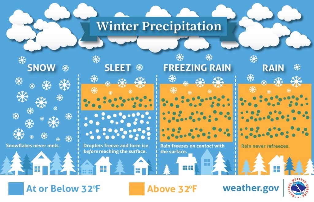 🧊 As for freezing precipitation, it remains a close call, but we think mobility impacts are increasingly likely around and within Houston.
🧊 Freezing rain will be likely to the west and north of Houston, in Waller, Grimes, Montgomery and Liberty counties.
🧊 I think the jury is still out on Harris County and points closer to the coast.
🧊 However, by Saturday afternoon, or early evening, this will be a distinct possibility and you should factor that into your travel plans around the area - i.e. have a contingency plan to remain in place. More on the timing of this below. FRIDAY - *This will be another warm day with a fair bit of humidity.
*The morning hours will likely be rain free, but we should see some scattered showers later in the day.
*These chances will increase on Friday evening and overnight as the front approaches.
*Highs on Friday will be in the range of 70 degrees, with temperatures falling sharply as the front moves through.
*If you're planning to drive to the Dallas or Austin areas this weekend, I would advise you to arrive there by or before midnight on Friday evening, at which time ice could start to accumulate on streets. 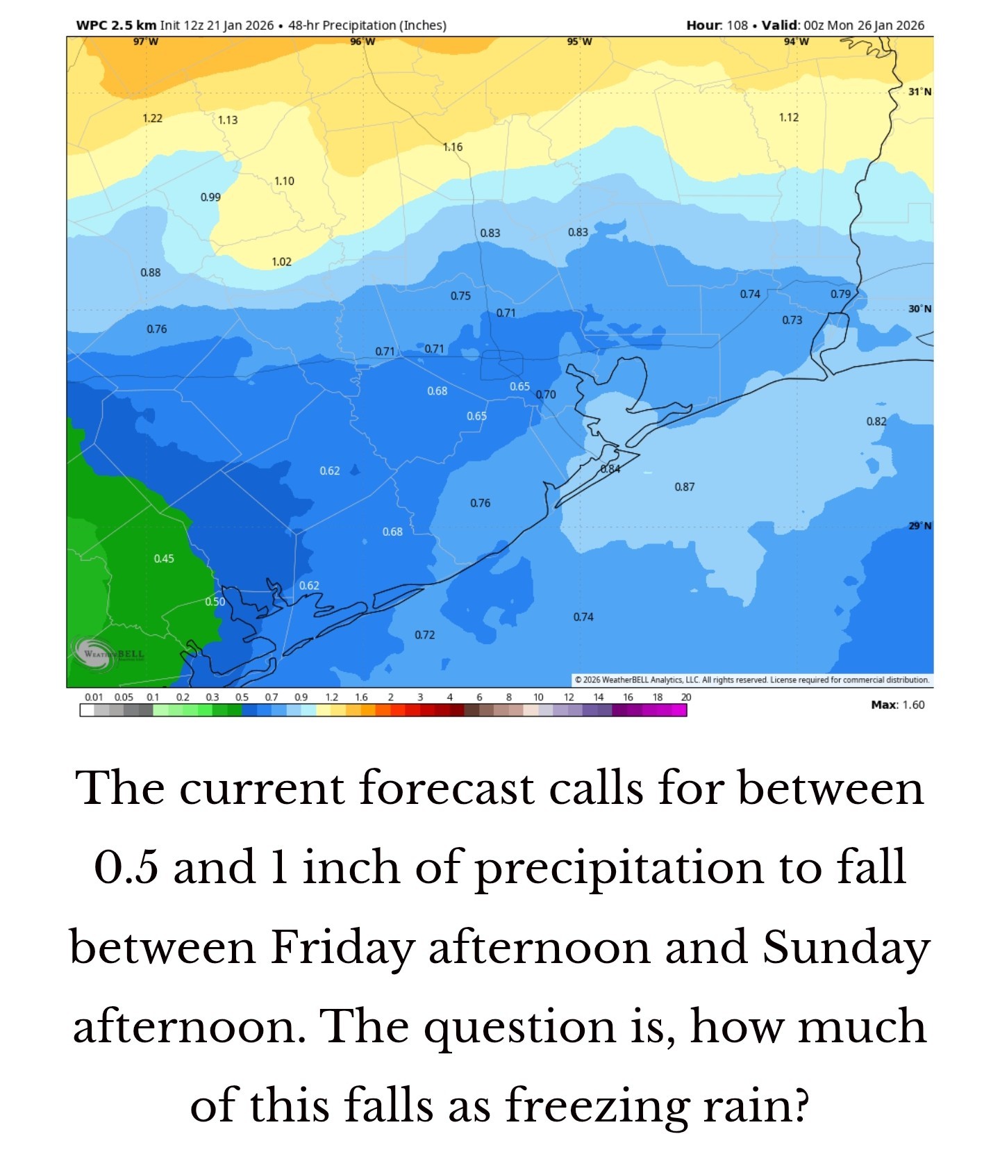 SATURDAY - 🧊 One of the big uncertainties I still have concerns the timing of the front moving into the Houston region.
🧊 There is a world in which the colder air does not arrive in the city itself until midday Saturday, but I think it is more likely to move in earlier, perhaps around sunrise. We'll see.
🧊🚗 I think air temperatures will remain above freezing throughout the daytime in the city, allowing for normal mobility despite widespread showers.
🧊🚗 For areas west and north of the city, such as Montgomery and Waller counties, freezing temperatures appear to be possible starting Saturday afternoon, so please be flexible in terms of your plans this weekend.
🧊🚗 Whether we see freezing rain on Saturday afternoon and Saturday night depends on how quickly the cold air moves in, and how quickly the precipitation exits to the east.
🧊🚗 I think the best advice I can give you is to be prepared for the possibility of ice on roads in Houston from late Saturday afternoon onward.
🧊🚗 That does not mean it is for certain, but it is distinctly possible with wet roads and falling temperatures.
🧊 Lows on Saturday night will fall into the 20s, most likely, but whether that's the low 20s or upper 20s will depend on how close you live to the coast. 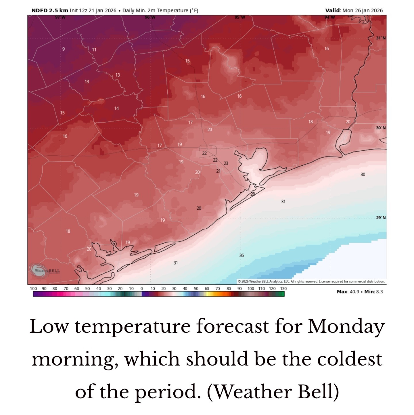 SUNDAY - This will be a very cold day 🥶 ➡️🧊 Highs for many locations may not reach above freezing (32 degrees), or do so only briefly.
🧊 My best guess is that the precipitation will exit our region some time between midnight on Saturday and noon on Sunday.
🧊🚗 Given the confluence of freezing air and moisture on roadways, I think it reasonable to expect, at a minimum, icy patches on roadways on Sunday.
‼️ It could be worse, and we could have a full blown ice rink out there.
🧊🚗 For now, we can't say for sure, but the bottom line is that mobility on Sunday, in Houston, will be a big question mark.
🧊 Sunday night looks to be the coldest night of the period, with lows dropping to 20 - 25 degrees in urban parts of Houston, with cooler temperatures outside the city. MONDAY - 🧊 We will finally see some sunshine on Monday.
🧊🚗 I know everyone would like to know what the roads will look like on Monday, but that will depend on a lot of factors that are difficult to predict.
🧊🚗 If you're trying to make plans for school, or work, or otherwise on Monday morning, it is definitely possible that there is some lingering ice from the weekend's rain.
🧊🚗 It will depend on the amount of precipitation, how warm temperatures get Sunday, efforts to clear streets, and other factors I don't feel confident in predicting.
🧊🚗 Yes, there's the potential for impacts.
🧊 Expect mostly sunny skies and highs in at least the upper 30s on Monday.
🧊 I think we can finally clear most ice impacts later in the day.
🧊 Monday night will be very cold again with temperatures likely dropping into the low to mid 20s again. NEXT WEEK - *The rest of next week should see conditions moderate a little, with highs in the 50s and lows in the 30s, or thereabouts. The bottom line is that it will remain quite cold for the remainder of January. Our next update will be published by 3 pm CT today.


rena, Txbutterfly and Miro2019 + 9 more reacted *These are associated with a weak (and dying) front that will sag into Houston today.
*Accordingly, I expect light to moderate showers throughout the day in our region, although accumulations for most will be on the order of a few tenths of an inch.
*So expect no serious impacts.
*Highs will near 70 degrees for most locations, with cloudy skies, and light southerly winds.
*Rain chances slacken this evening with lows tonight only dropping to around 60 degrees.
🧊 It now appears likely that Texas will see a direct shot of Arctic air, rather than a glancing blow.
🧊 A large parts of the region will likely experience temperatures of 25 degrees - or below - on Saturday, Sunday, and possibly Monday nights.
🧊 For some inland areas, such as Katy, Cypress, and The Woodlands, temperatures in the upper teens are possible.
🧊 Actions to protect pipes and vegetation should be taken.
🧊 Freezing rain will be likely to the west and north of Houston, in Waller, Grimes, Montgomery and Liberty counties.
🧊 I think the jury is still out on Harris County and points closer to the coast.
🧊 However, by Saturday afternoon, or early evening, this will be a distinct possibility and you should factor that into your travel plans around the area - i.e. have a contingency plan to remain in place.
*The morning hours will likely be rain free, but we should see some scattered showers later in the day.
*These chances will increase on Friday evening and overnight as the front approaches.
*Highs on Friday will be in the range of 70 degrees, with temperatures falling sharply as the front moves through.
*If you're planning to drive to the Dallas or Austin areas this weekend, I would advise you to arrive there by or before midnight on Friday evening, at which time ice could start to accumulate on streets.
🧊 There is a world in which the colder air does not arrive in the city itself until midday Saturday, but I think it is more likely to move in earlier, perhaps around sunrise. We'll see.
🧊🚗 I think air temperatures will remain above freezing throughout the daytime in the city, allowing for normal mobility despite widespread showers.
🧊🚗 For areas west and north of the city, such as Montgomery and Waller counties, freezing temperatures appear to be possible starting Saturday afternoon, so please be flexible in terms of your plans this weekend.
🧊🚗 Whether we see freezing rain on Saturday afternoon and Saturday night depends on how quickly the cold air moves in, and how quickly the precipitation exits to the east.
🧊🚗 I think the best advice I can give you is to be prepared for the possibility of ice on roads in Houston from late Saturday afternoon onward.
🧊🚗 That does not mean it is for certain, but it is distinctly possible with wet roads and falling temperatures.
🧊 Lows on Saturday night will fall into the 20s, most likely, but whether that's the low 20s or upper 20s will depend on how close you live to the coast.
🧊 My best guess is that the precipitation will exit our region some time between midnight on Saturday and noon on Sunday.
🧊🚗 Given the confluence of freezing air and moisture on roadways, I think it reasonable to expect, at a minimum, icy patches on roadways on Sunday.
‼️ It could be worse, and we could have a full blown ice rink out there.
🧊🚗 For now, we can't say for sure, but the bottom line is that mobility on Sunday, in Houston, will be a big question mark.
🧊 Sunday night looks to be the coldest night of the period, with lows dropping to 20 - 25 degrees in urban parts of Houston, with cooler temperatures outside the city.
🧊🚗 I know everyone would like to know what the roads will look like on Monday, but that will depend on a lot of factors that are difficult to predict.
🧊🚗 If you're trying to make plans for school, or work, or otherwise on Monday morning, it is definitely possible that there is some lingering ice from the weekend's rain.
🧊🚗 It will depend on the amount of precipitation, how warm temperatures get Sunday, efforts to clear streets, and other factors I don't feel confident in predicting.
🧊🚗 Yes, there's the potential for impacts.
🧊 Expect mostly sunny skies and highs in at least the upper 30s on Monday.
🧊 I think we can finally clear most ice impacts later in the day.
🧊 Monday night will be very cold again with temperatures likely dropping into the low to mid 20s again.
Replies:

|
StormChaser : Thanks so much for your report. So much of the "sky is falling" tv weather reports leave me frustrated with deciding what to do.
|
|
 StormChaser :
Thank you for the update. I really hope it's not as bad as they are saying it could be. I'd rather have much to do about nothing than get hammered. Regardless, I'm still going to prepare as if it's going to be bad.
Space City update 01/21 Lots of info this morning; but the bottom line is: ➡️ They are still unsure if we'll get a little ice.....or a lot. It all depends on what the temperature is when the rain arrives & also how much moisture is left on the roadways. Either way, we're going to have a very hard freeze Saturday night through Tuesday AM (not continously) with lows reaching the low-mid 20s on Sunday, Monday and Tuesday mornings. Preparations should be completed by Saturday morning at the latest as temperatures will begin to fall during the day Saturday. ..................... From Space City Weather: Houston now very likely to experience a hard freeze this weekend, with the potential for freezing rain and icy roads. Eric Berger · Wednesday, January 21, 2026 6:59 AM In brief: *In today's post, we go in depth on the timing, and potential impacts of a winter storm this weekend. TODAY: *At sunrise this morning, we have a mass of moderate showers to the northwest of the region, having just passed through College Station.
*These are associated with a weak (and dying) front that will sag into Houston today.
*Accordingly, I expect light to moderate showers throughout the day in our region, although accumulations for most will be on the order of a few tenths of an inch.
*So expect no serious impacts.
*Highs will near 70 degrees for most locations, with cloudy skies, and light southerly winds.
*Rain chances slacken this evening with lows tonight only dropping to around 60 degrees. WINTER STORM STATUS - ? Based upon the latest modeling data, we are increasingly confident in a hard freeze for the majority of the Houston metro area this weekend, for all but the immediate coast.
? It now appears likely that Texas will see a direct shot of Arctic air, rather than a glancing blow.
? A large parts of the region will likely experience temperatures of 25 degrees - or below - on Saturday, Sunday, and possibly Monday nights.
? For some inland areas, such as Katy, Cypress, and The Woodlands, temperatures in the upper teens are possible.
? Actions to protect pipes and vegetation should be taken. ? As for freezing precipitation, it remains a close call, but we think mobility impacts are increasingly likely around and within Houston.
? Freezing rain will be likely to the west and north of Houston, in Waller, Grimes, Montgomery and Liberty counties.
? I think the jury is still out on Harris County and points closer to the coast.
? However, by Saturday afternoon, or early evening, this will be a distinct possibility and you should factor that into your travel plans around the area - i.e. have a contingency plan to remain in place. More on the timing of this below. FRIDAY - *This will be another warm day with a fair bit of humidity.
*The morning hours will likely be rain free, but we should see some scattered showers later in the day.
*These chances will increase on Friday evening and overnight as the front approaches.
*Highs on Friday will be in the range of 70 degrees, with temperatures falling sharply as the front moves through.
*If you're planning to drive to the Dallas or Austin areas this weekend, I would advise you to arrive there by or before midnight on Friday evening, at which time ice could start to accumulate on streets. SATURDAY - ? One of the big uncertainties I still have concerns the timing of the front moving into the Houston region.
? There is a world in which the colder air does not arrive in the city itself until midday Saturday, but I think it is more likely to move in earlier, perhaps around sunrise. We'll see.
?? I think air temperatures will remain above freezing throughout the daytime in the city, allowing for normal mobility despite widespread showers.
?? For areas west and north of the city, such as Montgomery and Waller counties, freezing temperatures appear to be possible starting Saturday afternoon, so please be flexible in terms of your plans this weekend.
?? Whether we see freezing rain on Saturday afternoon and Saturday night depends on how quickly the cold air moves in, and how quickly the precipitation exits to the east.
?? I think the best advice I can give you is to be prepared for the possibility of ice on roads in Houston from late Saturday afternoon onward.
?? That does not mean it is for certain, but it is distinctly possible with wet roads and falling temperatures.
? Lows on Saturday night will fall into the 20s, most likely, but whether that's the low 20s or upper 20s will depend on how close you live to the coast. SUNDAY - This will be a very cold day ? ➡️? Highs for many locations may not reach above freezing (32 degrees), or do so only briefly.
? My best guess is that the precipitation will exit our region some time between midnight on Saturday and noon on Sunday.
?? Given the confluence of freezing air and moisture on roadways, I think it reasonable to expect, at a minimum, icy patches on roadways on Sunday.
‼️ It could be worse, and we could have a full blown ice rink out there.
?? For now, we can't say for sure, but the bottom line is that mobility on Sunday, in Houston, will be a big question mark.
? Sunday night looks to be the coldest night of the period, with lows dropping to 20 - 25 degrees in urban parts of Houston, with cooler temperatures outside the city. MONDAY - ? We will finally see some sunshine on Monday.
?? I know everyone would like to know what the roads will look like on Monday, but that will depend on a lot of factors that are difficult to predict.
?? If you're trying to make plans for school, or work, or otherwise on Monday morning, it is definitely possible that there is some lingering ice from the weekend's rain.
?? It will depend on the amount of precipitation, how warm temperatures get Sunday, efforts to clear streets, and other factors I don't feel confident in predicting.
?? Yes, there's the potential for impacts.
? Expect mostly sunny skies and highs in at least the upper 30s on Monday.
? I think we can finally clear most ice impacts later in the day.
? Monday night will be very cold again with temperatures likely dropping into the low to mid 20s again. NEXT WEEK - *The rest of next week should see conditions moderate a little, with highs in the 50s and lows in the 30s, or thereabouts. The bottom line is that it will remain quite cold for the remainder of January. Our next update will be published by 3 pm CT today.
*These are associated with a weak (and dying) front that will sag into Houston today.
*Accordingly, I expect light to moderate showers throughout the day in our region, although accumulations for most will be on the order of a few tenths of an inch.
*So expect no serious impacts.
*Highs will near 70 degrees for most locations, with cloudy skies, and light southerly winds.
*Rain chances slacken this evening with lows tonight only dropping to around 60 degrees.
? It now appears likely that Texas will see a direct shot of Arctic air, rather than a glancing blow.
? A large parts of the region will likely experience temperatures of 25 degrees - or below - on Saturday, Sunday, and possibly Monday nights.
? For some inland areas, such as Katy, Cypress, and The Woodlands, temperatures in the upper teens are possible.
? Actions to protect pipes and vegetation should be taken.
? Freezing rain will be likely to the west and north of Houston, in Waller, Grimes, Montgomery and Liberty counties.
? I think the jury is still out on Harris County and points closer to the coast.
? However, by Saturday afternoon, or early evening, this will be a distinct possibility and you should factor that into your travel plans around the area - i.e. have a contingency plan to remain in place.
*The morning hours will likely be rain free, but we should see some scattered showers later in the day.
*These chances will increase on Friday evening and overnight as the front approaches.
*Highs on Friday will be in the range of 70 degrees, with temperatures falling sharply as the front moves through.
*If you're planning to drive to the Dallas or Austin areas this weekend, I would advise you to arrive there by or before midnight on Friday evening, at which time ice could start to accumulate on streets.
? There is a world in which the colder air does not arrive in the city itself until midday Saturday, but I think it is more likely to move in earlier, perhaps around sunrise. We'll see.
?? I think air temperatures will remain above freezing throughout the daytime in the city, allowing for normal mobility despite widespread showers.
?? For areas west and north of the city, such as Montgomery and Waller counties, freezing temperatures appear to be possible starting Saturday afternoon, so please be flexible in terms of your plans this weekend.
?? Whether we see freezing rain on Saturday afternoon and Saturday night depends on how quickly the cold air moves in, and how quickly the precipitation exits to the east.
?? I think the best advice I can give you is to be prepared for the possibility of ice on roads in Houston from late Saturday afternoon onward.
?? That does not mean it is for certain, but it is distinctly possible with wet roads and falling temperatures.
? Lows on Saturday night will fall into the 20s, most likely, but whether that's the low 20s or upper 20s will depend on how close you live to the coast.
? My best guess is that the precipitation will exit our region some time between midnight on Saturday and noon on Sunday.
?? Given the confluence of freezing air and moisture on roadways, I think it reasonable to expect, at a minimum, icy patches on roadways on Sunday.
‼️ It could be worse, and we could have a full blown ice rink out there.
?? For now, we can't say for sure, but the bottom line is that mobility on Sunday, in Houston, will be a big question mark.
? Sunday night looks to be the coldest night of the period, with lows dropping to 20 - 25 degrees in urban parts of Houston, with cooler temperatures outside the city.
?? I know everyone would like to know what the roads will look like on Monday, but that will depend on a lot of factors that are difficult to predict.
?? If you're trying to make plans for school, or work, or otherwise on Monday morning, it is definitely possible that there is some lingering ice from the weekend's rain.
?? It will depend on the amount of precipitation, how warm temperatures get Sunday, efforts to clear streets, and other factors I don't feel confident in predicting.
?? Yes, there's the potential for impacts.
? Expect mostly sunny skies and highs in at least the upper 30s on Monday.
? I think we can finally clear most ice impacts later in the day.
? Monday night will be very cold again with temperatures likely dropping into the low to mid 20s again.
Wingsofwonder tipped StormChaser 100 credits for a post in this forum discussion.
|
|
StormChaser : Thank you for the update. I really hope it's not as bad as they are saying it could be. I'd rather have much to do about nothing than get hammered. Regardless, I'm still going to prepare as if it's going to be bad.
Weathergirl5 : 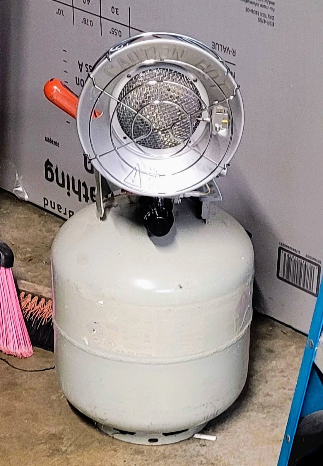

|
|
StormChaser : Yes, we will be covering plants and bringing some into the garage as well. I'm going to work on a menu today during my lunch break and figure out what I need to get at the store to last through Tuesday. I usually do my grocery shopping on the weekend, but it looks like that's not going to happen.
|
|
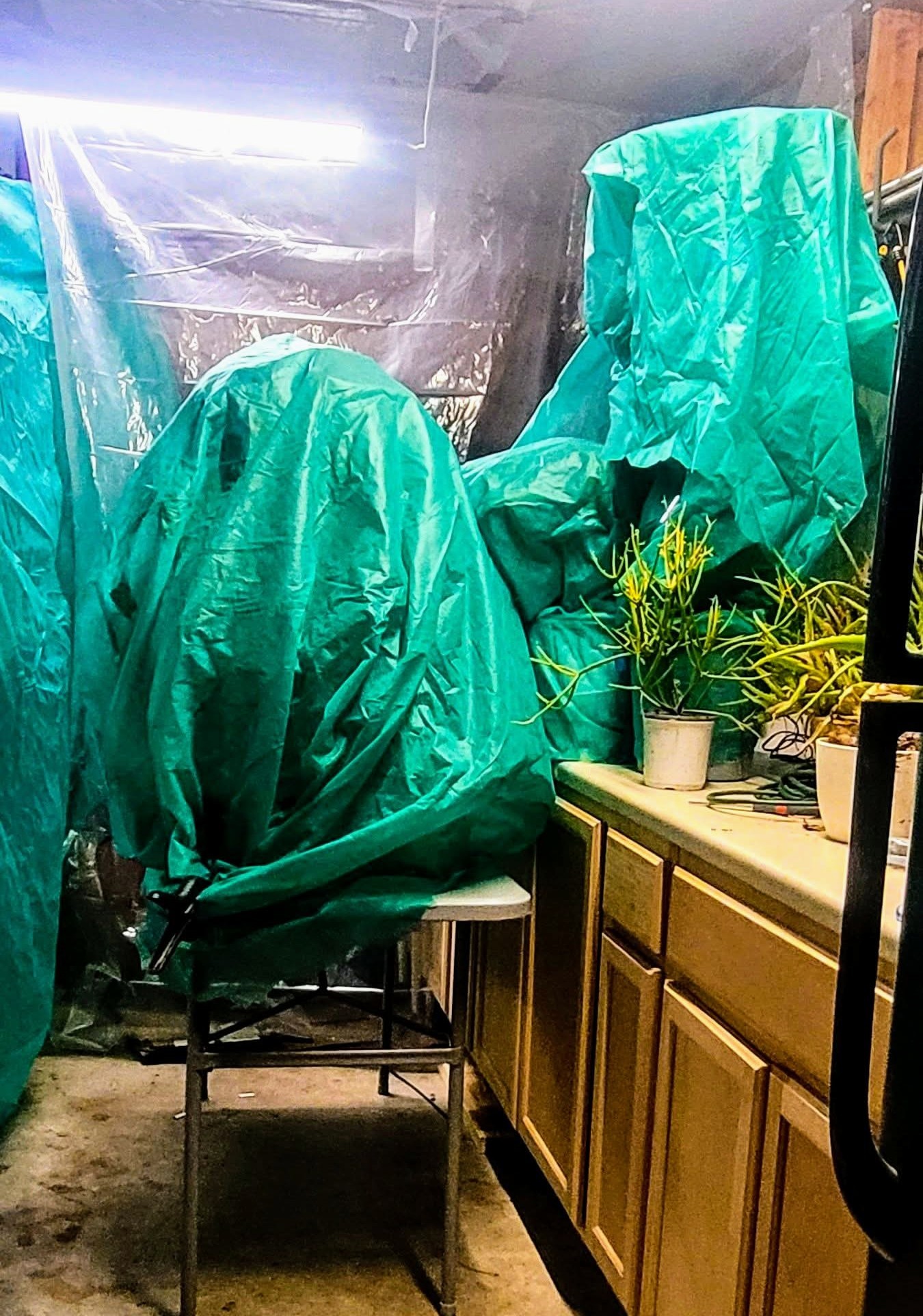
Weathergirl5 : Yeah we got a few extra things yesterday at the store yesterday and we're winterizating the sprinkler system & water well this afternoon. I also have to set up the garage for plants! I did this (pics below) in 2021 and saved all my outdoor stuff so I plan to do it again. I don't bring outdoor pants inside because I don't want bugs getting to my indoor plants. Propane tank patio heater: Plants covered with freeze cloths: We walled off most of the garage with plastic to insulate the area we put the plants in. It kept the temperature at 60° the entire time. 👍 Not pretty but it works!
StormChaser : You have got quite an operation going there girl!
|
|
I usually do my grocery shopping on the weekend, but it looks like that's not going to happen.
Weathergirl5 : 
|
|
StormChaser : Yes, we will be covering plants and bringing some into the garage as well. I'm going to work on a menu today during my lunch break and figure out what I need to get at the store to last through Tuesday. I usually do my grocery shopping on the weekend, but it looks like that's not going to happen.
 Weathergirl5 : I'm sure HEB with be insane the closer we get to the weekend. People prepping like a Hurricane.
|
|
StormChaser : Yeah, no! I would look just like that lady. I can't afford to break any bones at this age.
|
|
StormChaser : Thank you for the information and updates. I love SCW because they just give you the facts without all the hype. We are preparing for the worst but hoping for the best, and I hope everyone stays safe and warm!
Space City update 01/21 Lots of info this morning; but the bottom line is: ➡️ They are still unsure if we'll get a little ice.....or a lot. It all depends on what the temperature is when the rain arrives & also how much moisture is left on the roadways. Either way, we're going to have a very hard freeze Saturday night through Tuesday AM (not continously) with lows reaching the low-mid 20s on Sunday, Monday and Tuesday mornings. Preparations should be completed by Saturday morning at the latest as temperatures will begin to fall during the day Saturday. ..................... From Space City Weather: Houston now very likely to experience a hard freeze this weekend, with the potential for freezing rain and icy roads. Eric Berger · Wednesday, January 21, 2026 6:59 AM In brief: *In today's post, we go in depth on the timing, and potential impacts of a winter storm this weekend. TODAY: *At sunrise this morning, we have a mass of moderate showers to the northwest of the region, having just passed through College Station.
*These are associated with a weak (and dying) front that will sag into Houston today.
*Accordingly, I expect light to moderate showers throughout the day in our region, although accumulations for most will be on the order of a few tenths of an inch.
*So expect no serious impacts.
*Highs will near 70 degrees for most locations, with cloudy skies, and light southerly winds.
*Rain chances slacken this evening with lows tonight only dropping to around 60 degrees. WINTER STORM STATUS - ? Based upon the latest modeling data, we are increasingly confident in a hard freeze for the majority of the Houston metro area this weekend, for all but the immediate coast.
? It now appears likely that Texas will see a direct shot of Arctic air, rather than a glancing blow.
? A large parts of the region will likely experience temperatures of 25 degrees - or below - on Saturday, Sunday, and possibly Monday nights.
? For some inland areas, such as Katy, Cypress, and The Woodlands, temperatures in the upper teens are possible.
? Actions to protect pipes and vegetation should be taken. ? As for freezing precipitation, it remains a close call, but we think mobility impacts are increasingly likely around and within Houston.
? Freezing rain will be likely to the west and north of Houston, in Waller, Grimes, Montgomery and Liberty counties.
? I think the jury is still out on Harris County and points closer to the coast.
? However, by Saturday afternoon, or early evening, this will be a distinct possibility and you should factor that into your travel plans around the area - i.e. have a contingency plan to remain in place. More on the timing of this below. FRIDAY - *This will be another warm day with a fair bit of humidity.
*The morning hours will likely be rain free, but we should see some scattered showers later in the day.
*These chances will increase on Friday evening and overnight as the front approaches.
*Highs on Friday will be in the range of 70 degrees, with temperatures falling sharply as the front moves through.
*If you're planning to drive to the Dallas or Austin areas this weekend, I would advise you to arrive there by or before midnight on Friday evening, at which time ice could start to accumulate on streets. SATURDAY - ? One of the big uncertainties I still have concerns the timing of the front moving into the Houston region.
? There is a world in which the colder air does not arrive in the city itself until midday Saturday, but I think it is more likely to move in earlier, perhaps around sunrise. We'll see.
?? I think air temperatures will remain above freezing throughout the daytime in the city, allowing for normal mobility despite widespread showers.
?? For areas west and north of the city, such as Montgomery and Waller counties, freezing temperatures appear to be possible starting Saturday afternoon, so please be flexible in terms of your plans this weekend.
?? Whether we see freezing rain on Saturday afternoon and Saturday night depends on how quickly the cold air moves in, and how quickly the precipitation exits to the east.
?? I think the best advice I can give you is to be prepared for the possibility of ice on roads in Houston from late Saturday afternoon onward.
?? That does not mean it is for certain, but it is distinctly possible with wet roads and falling temperatures.
? Lows on Saturday night will fall into the 20s, most likely, but whether that's the low 20s or upper 20s will depend on how close you live to the coast. SUNDAY - This will be a very cold day ? ➡️? Highs for many locations may not reach above freezing (32 degrees), or do so only briefly.
? My best guess is that the precipitation will exit our region some time between midnight on Saturday and noon on Sunday.
?? Given the confluence of freezing air and moisture on roadways, I think it reasonable to expect, at a minimum, icy patches on roadways on Sunday.
‼️ It could be worse, and we could have a full blown ice rink out there.
?? For now, we can't say for sure, but the bottom line is that mobility on Sunday, in Houston, will be a big question mark.
? Sunday night looks to be the coldest night of the period, with lows dropping to 20 - 25 degrees in urban parts of Houston, with cooler temperatures outside the city. MONDAY - ? We will finally see some sunshine on Monday.
?? I know everyone would like to know what the roads will look like on Monday, but that will depend on a lot of factors that are difficult to predict.
?? If you're trying to make plans for school, or work, or otherwise on Monday morning, it is definitely possible that there is some lingering ice from the weekend's rain.
?? It will depend on the amount of precipitation, how warm temperatures get Sunday, efforts to clear streets, and other factors I don't feel confident in predicting.
?? Yes, there's the potential for impacts.
? Expect mostly sunny skies and highs in at least the upper 30s on Monday.
? I think we can finally clear most ice impacts later in the day.
? Monday night will be very cold again with temperatures likely dropping into the low to mid 20s again. NEXT WEEK - *The rest of next week should see conditions moderate a little, with highs in the 50s and lows in the 30s, or thereabouts. The bottom line is that it will remain quite cold for the remainder of January. Our next update will be published by 3 pm CT today.
*These are associated with a weak (and dying) front that will sag into Houston today.
*Accordingly, I expect light to moderate showers throughout the day in our region, although accumulations for most will be on the order of a few tenths of an inch.
*So expect no serious impacts.
*Highs will near 70 degrees for most locations, with cloudy skies, and light southerly winds.
*Rain chances slacken this evening with lows tonight only dropping to around 60 degrees.
? It now appears likely that Texas will see a direct shot of Arctic air, rather than a glancing blow.
? A large parts of the region will likely experience temperatures of 25 degrees - or below - on Saturday, Sunday, and possibly Monday nights.
? For some inland areas, such as Katy, Cypress, and The Woodlands, temperatures in the upper teens are possible.
? Actions to protect pipes and vegetation should be taken.
? Freezing rain will be likely to the west and north of Houston, in Waller, Grimes, Montgomery and Liberty counties.
? I think the jury is still out on Harris County and points closer to the coast.
? However, by Saturday afternoon, or early evening, this will be a distinct possibility and you should factor that into your travel plans around the area - i.e. have a contingency plan to remain in place.
*The morning hours will likely be rain free, but we should see some scattered showers later in the day.
*These chances will increase on Friday evening and overnight as the front approaches.
*Highs on Friday will be in the range of 70 degrees, with temperatures falling sharply as the front moves through.
*If you're planning to drive to the Dallas or Austin areas this weekend, I would advise you to arrive there by or before midnight on Friday evening, at which time ice could start to accumulate on streets.
? There is a world in which the colder air does not arrive in the city itself until midday Saturday, but I think it is more likely to move in earlier, perhaps around sunrise. We'll see.
?? I think air temperatures will remain above freezing throughout the daytime in the city, allowing for normal mobility despite widespread showers.
?? For areas west and north of the city, such as Montgomery and Waller counties, freezing temperatures appear to be possible starting Saturday afternoon, so please be flexible in terms of your plans this weekend.
?? Whether we see freezing rain on Saturday afternoon and Saturday night depends on how quickly the cold air moves in, and how quickly the precipitation exits to the east.
?? I think the best advice I can give you is to be prepared for the possibility of ice on roads in Houston from late Saturday afternoon onward.
?? That does not mean it is for certain, but it is distinctly possible with wet roads and falling temperatures.
? Lows on Saturday night will fall into the 20s, most likely, but whether that's the low 20s or upper 20s will depend on how close you live to the coast.
? My best guess is that the precipitation will exit our region some time between midnight on Saturday and noon on Sunday.
?? Given the confluence of freezing air and moisture on roadways, I think it reasonable to expect, at a minimum, icy patches on roadways on Sunday.
‼️ It could be worse, and we could have a full blown ice rink out there.
?? For now, we can't say for sure, but the bottom line is that mobility on Sunday, in Houston, will be a big question mark.
? Sunday night looks to be the coldest night of the period, with lows dropping to 20 - 25 degrees in urban parts of Houston, with cooler temperatures outside the city.
?? I know everyone would like to know what the roads will look like on Monday, but that will depend on a lot of factors that are difficult to predict.
?? If you're trying to make plans for school, or work, or otherwise on Monday morning, it is definitely possible that there is some lingering ice from the weekend's rain.
?? It will depend on the amount of precipitation, how warm temperatures get Sunday, efforts to clear streets, and other factors I don't feel confident in predicting.
?? Yes, there's the potential for impacts.
? Expect mostly sunny skies and highs in at least the upper 30s on Monday.
? I think we can finally clear most ice impacts later in the day.
? Monday night will be very cold again with temperatures likely dropping into the low to mid 20s again.
@CatalinaKitKat tipped
StormChaser 100 credits for a post in this forum discussion.
|
|
20° Monday AM 😳🥶 Jeff Lindner
1-21-26 720am Significant winter storm to impact much of Texas this weekend…widespread travel impacts are likely.
Dangerously cold temperatures and wind chills this weekend into early next week.
Increasing chances for freezing rain and ice accumulation for Houston metro Saturday and Sunday
Maximum winterization preparation will be needed for this event to help mitigate infrastructure damage…completed by Friday afternoon.
Unfortunately, the trend in the last 24 hours has been generally colder across the guidance spectrum yielding a continued decrease in the temperature forecast. Arctic front looks to arrive either late Friday afternoon or evening across the area (timing is still a bit uncertain) with falling temperatures and onset of gusty northerly winds. Freeze line likely to advance southward Friday night/Sat AM to a line from Columbus to Hempstead to Porter and then continue southward during the day reaching the I-10 corridor midday to mid afternoon and the coast by early to mid evening. How quickly the freezing line moves south will be very important on freezing rain probabilities and ice accumulations.
Hard freeze (24 or below) is likely for much of the area on Sun AM and even colder Mon AM with lows into the upper 10's outside the Beltway and low to mid 20's to the coast…and mid (possibly even low) 10's across the Brazos valley….this will be a damaging freeze. High temperatures on Sunday will struggle to reach freezing and this may result in duration of temperatures below freezing nearing 40 hours or longer for much of the metro Houston area and up to 72 hours for areas to the north and west. High temperatures on Monday may only reach the mid to upper 30's for a few hours.
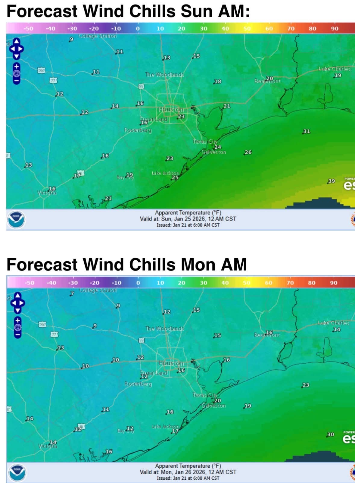
Wind chills will become dangerous with values falling into the 10's late Saturday into much of Sun (low 20's in the Houston metro) and then down to the low 10's Sunday night into Monday AM (could even get 1's in north and west areas).
Precipitation:
SE TX will be on the southern edge of a potentially catastrophic and crippling ice storm across interior TX
Chances for ice accumulation have increased across all of SE TX with potential for at least minor accumulation to the coast.
Travel impacts are increasingly likely across much of the region.
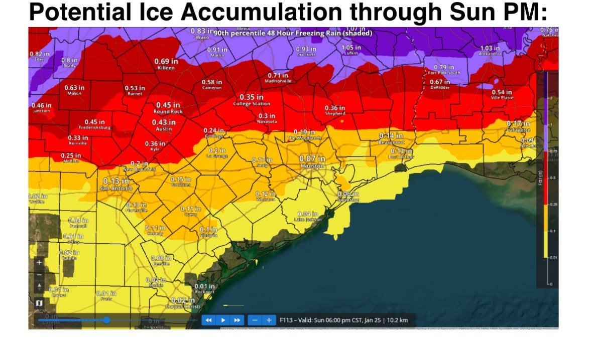
Once the arctic front is through Friday evening the freezing line will advance southward…GFS appears to be resolving the intensity of the cold air mass best and pushes the freezing line toward I-10 by midday Saturday with freezing rain developing southward during the day. There is still some uncertainty in how quickly this happens and the high resolution guidance tomorrow should help with timing onset of freezing precipitation. Given this faster onset the potential for higher ice accumulation of .05 to .20 of an inch is being brought toward the US 59 corridor with more significant accumulations of .25-.45 of an inch north of HWY 105. Ice accumulation of .20-.25 of an inch is where we begin to worry about power infrastructure damage along with vegetation impacts and areas north of HWY 105 look to reach this range. Freezing rain should gradually end around midday Sunday, but it is possible that freezing drizzle or mist lingers into Sunday afternoon given a saturated air column and very cold air which is effective a squeezing moisture out.
It should be noted that similar to rainfall events there will be pockets of higher ice accumulation and areas of lower accumulation and this is an early look at accumulations so changes up or down will be possible.
Additionally north winds of 15-20mph through the period will add additional stress to ice coated trees and power lines and isolated power outages will be possible even down to the coast.
Preparations:
Proper winterization of any exposed pipes/plumbing will be needed to prevent infrastructure damage. Sprinkler systems must be shut off and properly drained. Exterior facing wall pipes will be a risk of freezing at the forecasted temperatures.
Pets/livestock will require proper shelter to protect from the cold temperatures and wind chills.
Tropical plants/vegetation will require maximum freeze protection. Unprotected tropical vegetation will be killed and even protect vegetation will likely suffer heavy damage.
Persons should limit outdoor exposure during the cold. Utilize heating sources properly to reduce the risk of fire and carbon monoxide poisoning.
All cold weather preparations should be completed by Friday afternoon prior to the arrival of the cold front. 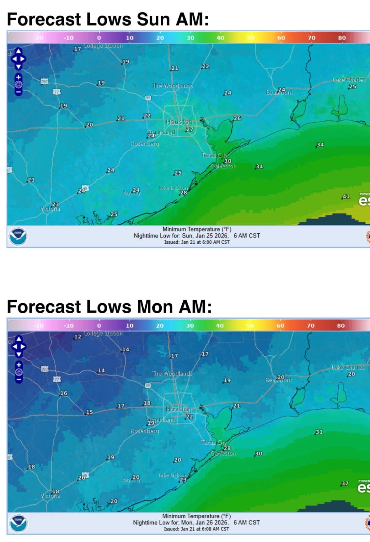
Miro2019 reacted 1-21-26 720am
Dangerously cold temperatures and wind chills this weekend into early next week.
Increasing chances for freezing rain and ice accumulation for Houston metro Saturday and Sunday
Maximum winterization preparation will be needed for this event to help mitigate infrastructure damage…completed by Friday afternoon.
Unfortunately, the trend in the last 24 hours has been generally colder across the guidance spectrum yielding a continued decrease in the temperature forecast. Arctic front looks to arrive either late Friday afternoon or evening across the area (timing is still a bit uncertain) with falling temperatures and onset of gusty northerly winds. Freeze line likely to advance southward Friday night/Sat AM to a line from Columbus to Hempstead to Porter and then continue southward during the day reaching the I-10 corridor midday to mid afternoon and the coast by early to mid evening. How quickly the freezing line moves south will be very important on freezing rain probabilities and ice accumulations.
Hard freeze (24 or below) is likely for much of the area on Sun AM and even colder Mon AM with lows into the upper 10's outside the Beltway and low to mid 20's to the coast…and mid (possibly even low) 10's across the Brazos valley….this will be a damaging freeze. High temperatures on Sunday will struggle to reach freezing and this may result in duration of temperatures below freezing nearing 40 hours or longer for much of the metro Houston area and up to 72 hours for areas to the north and west. High temperatures on Monday may only reach the mid to upper 30's for a few hours.
Wind chills will become dangerous with values falling into the 10's late Saturday into much of Sun (low 20's in the Houston metro) and then down to the low 10's Sunday night into Monday AM (could even get 1's in north and west areas).
Precipitation:
SE TX will be on the southern edge of a potentially catastrophic and crippling ice storm across interior TX
Chances for ice accumulation have increased across all of SE TX with potential for at least minor accumulation to the coast.
Travel impacts are increasingly likely across much of the region.
Once the arctic front is through Friday evening the freezing line will advance southward…GFS appears to be resolving the intensity of the cold air mass best and pushes the freezing line toward I-10 by midday Saturday with freezing rain developing southward during the day. There is still some uncertainty in how quickly this happens and the high resolution guidance tomorrow should help with timing onset of freezing precipitation. Given this faster onset the potential for higher ice accumulation of .05 to .20 of an inch is being brought toward the US 59 corridor with more significant accumulations of .25-.45 of an inch north of HWY 105. Ice accumulation of .20-.25 of an inch is where we begin to worry about power infrastructure damage along with vegetation impacts and areas north of HWY 105 look to reach this range. Freezing rain should gradually end around midday Sunday, but it is possible that freezing drizzle or mist lingers into Sunday afternoon given a saturated air column and very cold air which is effective a squeezing moisture out.
It should be noted that similar to rainfall events there will be pockets of higher ice accumulation and areas of lower accumulation and this is an early look at accumulations so changes up or down will be possible.
Additionally north winds of 15-20mph through the period will add additional stress to ice coated trees and power lines and isolated power outages will be possible even down to the coast.
Preparations:
Proper winterization of any exposed pipes/plumbing will be needed to prevent infrastructure damage. Sprinkler systems must be shut off and properly drained. Exterior facing wall pipes will be a risk of freezing at the forecasted temperatures.
Pets/livestock will require proper shelter to protect from the cold temperatures and wind chills.
Tropical plants/vegetation will require maximum freeze protection. Unprotected tropical vegetation will be killed and even protect vegetation will likely suffer heavy damage.
Persons should limit outdoor exposure during the cold. Utilize heating sources properly to reduce the risk of fire and carbon monoxide poisoning.
All cold weather preparations should be completed by Friday afternoon prior to the arrival of the cold front.
Space City update 01/21 Lots of info this morning; but the bottom line is: ➡️ They are still unsure if we'll get a little ice.....or a lot. It all depends on what the temperature is when the rain arrives & also how much moisture is left on the roadways. Either way, we're going to have a very hard freeze Saturday night through Tuesday AM (not continously) with lows reaching the low-mid 20s on Sunday, Monday and Tuesday mornings. Preparations should be completed by Saturday morning at the latest as temperatures will begin to fall during the day Saturday. ..................... From Space City Weather: Houston now very likely to experience a hard freeze this weekend, with the potential for freezing rain and icy roads. Eric Berger · Wednesday, January 21, 2026 6:59 AM In brief: *In today's post, we go in depth on the timing, and potential impacts of a winter storm this weekend. TODAY: *At sunrise this morning, we have a mass of moderate showers to the northwest of the region, having just passed through College Station.
*These are associated with a weak (and dying) front that will sag into Houston today.
*Accordingly, I expect light to moderate showers throughout the day in our region, although accumulations for most will be on the order of a few tenths of an inch.
*So expect no serious impacts.
*Highs will near 70 degrees for most locations, with cloudy skies, and light southerly winds.
*Rain chances slacken this evening with lows tonight only dropping to around 60 degrees. WINTER STORM STATUS - ? Based upon the latest modeling data, we are increasingly confident in a hard freeze for the majority of the Houston metro area this weekend, for all but the immediate coast.
? It now appears likely that Texas will see a direct shot of Arctic air, rather than a glancing blow.
? A large parts of the region will likely experience temperatures of 25 degrees - or below - on Saturday, Sunday, and possibly Monday nights.
? For some inland areas, such as Katy, Cypress, and The Woodlands, temperatures in the upper teens are possible.
? Actions to protect pipes and vegetation should be taken. ? As for freezing precipitation, it remains a close call, but we think mobility impacts are increasingly likely around and within Houston.
? Freezing rain will be likely to the west and north of Houston, in Waller, Grimes, Montgomery and Liberty counties.
? I think the jury is still out on Harris County and points closer to the coast.
? However, by Saturday afternoon, or early evening, this will be a distinct possibility and you should factor that into your travel plans around the area - i.e. have a contingency plan to remain in place. More on the timing of this below. FRIDAY - *This will be another warm day with a fair bit of humidity.
*The morning hours will likely be rain free, but we should see some scattered showers later in the day.
*These chances will increase on Friday evening and overnight as the front approaches.
*Highs on Friday will be in the range of 70 degrees, with temperatures falling sharply as the front moves through.
*If you're planning to drive to the Dallas or Austin areas this weekend, I would advise you to arrive there by or before midnight on Friday evening, at which time ice could start to accumulate on streets. SATURDAY - ? One of the big uncertainties I still have concerns the timing of the front moving into the Houston region.
? There is a world in which the colder air does not arrive in the city itself until midday Saturday, but I think it is more likely to move in earlier, perhaps around sunrise. We'll see.
?? I think air temperatures will remain above freezing throughout the daytime in the city, allowing for normal mobility despite widespread showers.
?? For areas west and north of the city, such as Montgomery and Waller counties, freezing temperatures appear to be possible starting Saturday afternoon, so please be flexible in terms of your plans this weekend.
?? Whether we see freezing rain on Saturday afternoon and Saturday night depends on how quickly the cold air moves in, and how quickly the precipitation exits to the east.
?? I think the best advice I can give you is to be prepared for the possibility of ice on roads in Houston from late Saturday afternoon onward.
?? That does not mean it is for certain, but it is distinctly possible with wet roads and falling temperatures.
? Lows on Saturday night will fall into the 20s, most likely, but whether that's the low 20s or upper 20s will depend on how close you live to the coast. SUNDAY - This will be a very cold day ? ➡️? Highs for many locations may not reach above freezing (32 degrees), or do so only briefly.
? My best guess is that the precipitation will exit our region some time between midnight on Saturday and noon on Sunday.
?? Given the confluence of freezing air and moisture on roadways, I think it reasonable to expect, at a minimum, icy patches on roadways on Sunday.
‼️ It could be worse, and we could have a full blown ice rink out there.
?? For now, we can't say for sure, but the bottom line is that mobility on Sunday, in Houston, will be a big question mark.
? Sunday night looks to be the coldest night of the period, with lows dropping to 20 - 25 degrees in urban parts of Houston, with cooler temperatures outside the city. MONDAY - ? We will finally see some sunshine on Monday.
?? I know everyone would like to know what the roads will look like on Monday, but that will depend on a lot of factors that are difficult to predict.
?? If you're trying to make plans for school, or work, or otherwise on Monday morning, it is definitely possible that there is some lingering ice from the weekend's rain.
?? It will depend on the amount of precipitation, how warm temperatures get Sunday, efforts to clear streets, and other factors I don't feel confident in predicting.
?? Yes, there's the potential for impacts.
? Expect mostly sunny skies and highs in at least the upper 30s on Monday.
? I think we can finally clear most ice impacts later in the day.
? Monday night will be very cold again with temperatures likely dropping into the low to mid 20s again. NEXT WEEK - *The rest of next week should see conditions moderate a little, with highs in the 50s and lows in the 30s, or thereabouts. The bottom line is that it will remain quite cold for the remainder of January. Our next update will be published by 3 pm CT today.
*These are associated with a weak (and dying) front that will sag into Houston today.
*Accordingly, I expect light to moderate showers throughout the day in our region, although accumulations for most will be on the order of a few tenths of an inch.
*So expect no serious impacts.
*Highs will near 70 degrees for most locations, with cloudy skies, and light southerly winds.
*Rain chances slacken this evening with lows tonight only dropping to around 60 degrees.
? It now appears likely that Texas will see a direct shot of Arctic air, rather than a glancing blow.
? A large parts of the region will likely experience temperatures of 25 degrees - or below - on Saturday, Sunday, and possibly Monday nights.
? For some inland areas, such as Katy, Cypress, and The Woodlands, temperatures in the upper teens are possible.
? Actions to protect pipes and vegetation should be taken.
? Freezing rain will be likely to the west and north of Houston, in Waller, Grimes, Montgomery and Liberty counties.
? I think the jury is still out on Harris County and points closer to the coast.
? However, by Saturday afternoon, or early evening, this will be a distinct possibility and you should factor that into your travel plans around the area - i.e. have a contingency plan to remain in place.
*The morning hours will likely be rain free, but we should see some scattered showers later in the day.
*These chances will increase on Friday evening and overnight as the front approaches.
*Highs on Friday will be in the range of 70 degrees, with temperatures falling sharply as the front moves through.
*If you're planning to drive to the Dallas or Austin areas this weekend, I would advise you to arrive there by or before midnight on Friday evening, at which time ice could start to accumulate on streets.
? There is a world in which the colder air does not arrive in the city itself until midday Saturday, but I think it is more likely to move in earlier, perhaps around sunrise. We'll see.
?? I think air temperatures will remain above freezing throughout the daytime in the city, allowing for normal mobility despite widespread showers.
?? For areas west and north of the city, such as Montgomery and Waller counties, freezing temperatures appear to be possible starting Saturday afternoon, so please be flexible in terms of your plans this weekend.
?? Whether we see freezing rain on Saturday afternoon and Saturday night depends on how quickly the cold air moves in, and how quickly the precipitation exits to the east.
?? I think the best advice I can give you is to be prepared for the possibility of ice on roads in Houston from late Saturday afternoon onward.
?? That does not mean it is for certain, but it is distinctly possible with wet roads and falling temperatures.
? Lows on Saturday night will fall into the 20s, most likely, but whether that's the low 20s or upper 20s will depend on how close you live to the coast.
? My best guess is that the precipitation will exit our region some time between midnight on Saturday and noon on Sunday.
?? Given the confluence of freezing air and moisture on roadways, I think it reasonable to expect, at a minimum, icy patches on roadways on Sunday.
‼️ It could be worse, and we could have a full blown ice rink out there.
?? For now, we can't say for sure, but the bottom line is that mobility on Sunday, in Houston, will be a big question mark.
? Sunday night looks to be the coldest night of the period, with lows dropping to 20 - 25 degrees in urban parts of Houston, with cooler temperatures outside the city.
?? I know everyone would like to know what the roads will look like on Monday, but that will depend on a lot of factors that are difficult to predict.
?? If you're trying to make plans for school, or work, or otherwise on Monday morning, it is definitely possible that there is some lingering ice from the weekend's rain.
?? It will depend on the amount of precipitation, how warm temperatures get Sunday, efforts to clear streets, and other factors I don't feel confident in predicting.
?? Yes, there's the potential for impacts.
? Expect mostly sunny skies and highs in at least the upper 30s on Monday.
? I think we can finally clear most ice impacts later in the day.
? Monday night will be very cold again with temperatures likely dropping into the low to mid 20s again.
Miro2019 tipped StormChaser 100 credits for a post in this forum discussion. « Back to Chat
Views: 951
# Replies: 19