


Severe weather - 12/26 (tornado watch issued)
Severe weather - 12/26 (tornado watch issued)


Joined:
X days ago
# Posts:
X,XXX
Contributor Points:
X


Severe weather potential - Today 12/26 1130am update: Tornado watch issued for all of SE Texas. .......... We have another storm system expected to move into SE Texas today with thunderstorms developing along and ahead of a cold front. ⚠️ The main window for severe weather potential will be roughly between 1 and 10 PM.
⚠️ A ~2pm-6pm time frame is likely if this forecast pans out.
⚠️ Multiple types of severe weather will be possible, including strong wind gusts, large hail, and isolated tornadoes. 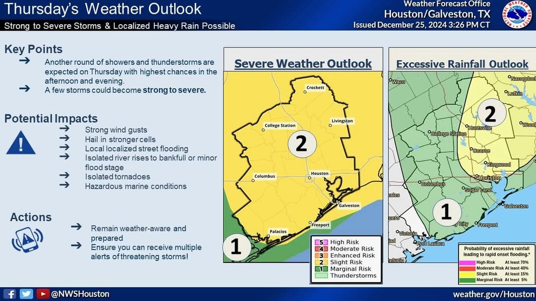 ⚠️ In addition to the severe weather threat, these storms may produce heavy downpours that could lead to a few instances of flash flooding.
⚠️ This threat is highest for locations north of I-10 and east of I-45 (see image below), and is compounded by the fact that soils are already well-saturated by the rainfall from Tuesday.
⚠️ Storm activity will shift gradually to the south after sunset and should taper off before midnight. ⚠️ It looks as though the supercells that will produce tornadoes (possibly even large tornadoes) should stay just off to our north (see map below) but it's close enough that it bears watching. Multiple storm chasers are setting up near Jasper TX. ⚠️ Targeted location as of 4am: 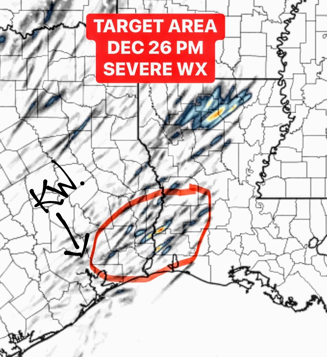 📞 Keep your phone alerts on just in case. It could be a bumpy afternoon....or it could be a bust. Either way, I still wanted to post. Merry (late) Christmas everyone. Stay safe. 🎄


⚠️ A ~2pm-6pm time frame is likely if this forecast pans out.
⚠️ Multiple types of severe weather will be possible, including strong wind gusts, large hail, and isolated tornadoes.
⚠️ This threat is highest for locations north of I-10 and east of I-45 (see image below), and is compounded by the fact that soils are already well-saturated by the rainfall from Tuesday.
⚠️ Storm activity will shift gradually to the south after sunset and should taper off before midnight.
Discussion Summary:
Severe Weather Alert: Potential for Strong Storms in SE Texas Today 12/26
Severe Weather Alert: Potential for Strong Storms in SE Texas Today 12/26
Discussion Insights:
Ask a question about this discussion and an AI bot will try to give an answer.
Ask a question about this discussion and an AI bot will try to give an answer.
Replies:

|
SIGNIFICANT SEVERE WEATHER EVENT ⚠️ The environment will become be very favorable today for all severe hazards (winds, hail, tornadoes) A STRONG (EF-2+) TORNADO or two will be possible tomorrow across East & SE Texas, eventually including Western Louisiana. ⚠️ Storm mode is looking......MESSY. Regardless, the ingredients will likely be present for tornadoes (one or two could be strong).
⚠️ Damaging winds and even hail will be hazards as well. ❗ It's one of those "Tornado Type Events" that can easily BUST because the atmosphere is fragile - the pendulum could swing either way. ❗ Fail modes would be too much precipitation across the warm sector with multiple storms fighting for surface based air and outflow would likely hinder tornadogensis. ⚠️ The environment can be there for a Significant Tornado Event (which is how we forecast, by the environmental ingredients) But the smaller/finer details at Storm scale is what makes or break a Significant Severe Weather Outbreak. PLEASE REMAIN WEATHER AWARE! 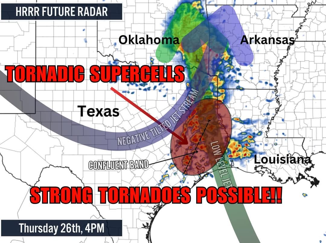
⚠️ Damaging winds and even hail will be hazards as well.
 StormChaser :
 Thank you for posting. I knew we could count on you!!! Belated Merry Christmas; hopefully it was a good day.
StormChaser : Thank you for the update and we are so glad you are back keeping us aware of weather alerts. Merry Christmas and Happy New Year to the best weathergirl.
|
|

Severe weather potential - Today 12/26 We have another storm system expected to move into SE Texas today with thunderstorms developing along and ahead of a cold front. ⚠️ The main window for severe weather potential will be roughly between 1 and 10 PM. ⚠️ A ~2pm-6pm time frame is likely if this forecast pans out. ⚠️ Multiple types of severe weather will be possible, including strong wind gusts, large hail, and isolated tornadoes. ⚠️ In addition to the severe weather threat, these storms may produce heavy downpours that could lead to a few instances of flash flooding. ⚠️ This threat is highest for locations north of I-10 and east of I-45 (see image below), and is compounded by the fact that soils are already well-saturated by the rainfall from Tuesday. ⚠️ Storm activity will shift gradually to the south after sunset and should taper off before midnight. ⚠️ It looks as though the supercells that will produce tornadoes (possibly even large tornadoes) should stay just off to our north (see map below) but it's close enough that it bears watching. Multiple storm chasers are setting up near Jasper TX. ⚠️ Targeted location as of 4am: 📞 Keep your phone alerts on just in case. It could be a bumpy afternoon....or it could be a bust. Either way, I still wanted to post. Merry (late) Christmas everyone. Stay safe. 🎄
StormChaser : Thank you for always keeping an eye out for all of us!!
StormChaser : Thanks, my friend. I miss your weather updates. I hope you and your family had a great Christmas 🎄.
SIGNIFICANT SEVERE WEATHER EVENT ⚠️ The environment will become be very favorable today for all severe hazards (winds, hail, tornadoes) A STRONG (EF-2+) TORNADO or two will be possible tomorrow across East & SE Texas, eventually including Western Louisiana. ⚠️ Storm mode is looking......MESSY. Regardless, the ingredients will likely be present for tornadoes (one or two could be strong). ⚠️ Damaging winds and even hail will be hazards as well. ❗ It's one of those "Tornado Type Events" that can easily BUST because the atmosphere is fragile - the pendulum could swing either way. ❗ Fail modes would be too much precipitation across the warm sector with multiple storms fighting for surface based air and outflow would likely hinder tornadogensis. ⚠️ The environment can be there for a Significant Tornado Event (which is how we forecast, by the environmental ingredients) But the smaller/finer details at Storm scale is what makes or break a Significant Severe Weather Outbreak. PLEASE REMAIN WEATHER AWARE!
StormChaser : Thanks for posting. I have to go to the Woodlands at 1. I might have to stay home.
|
|
Current radar:
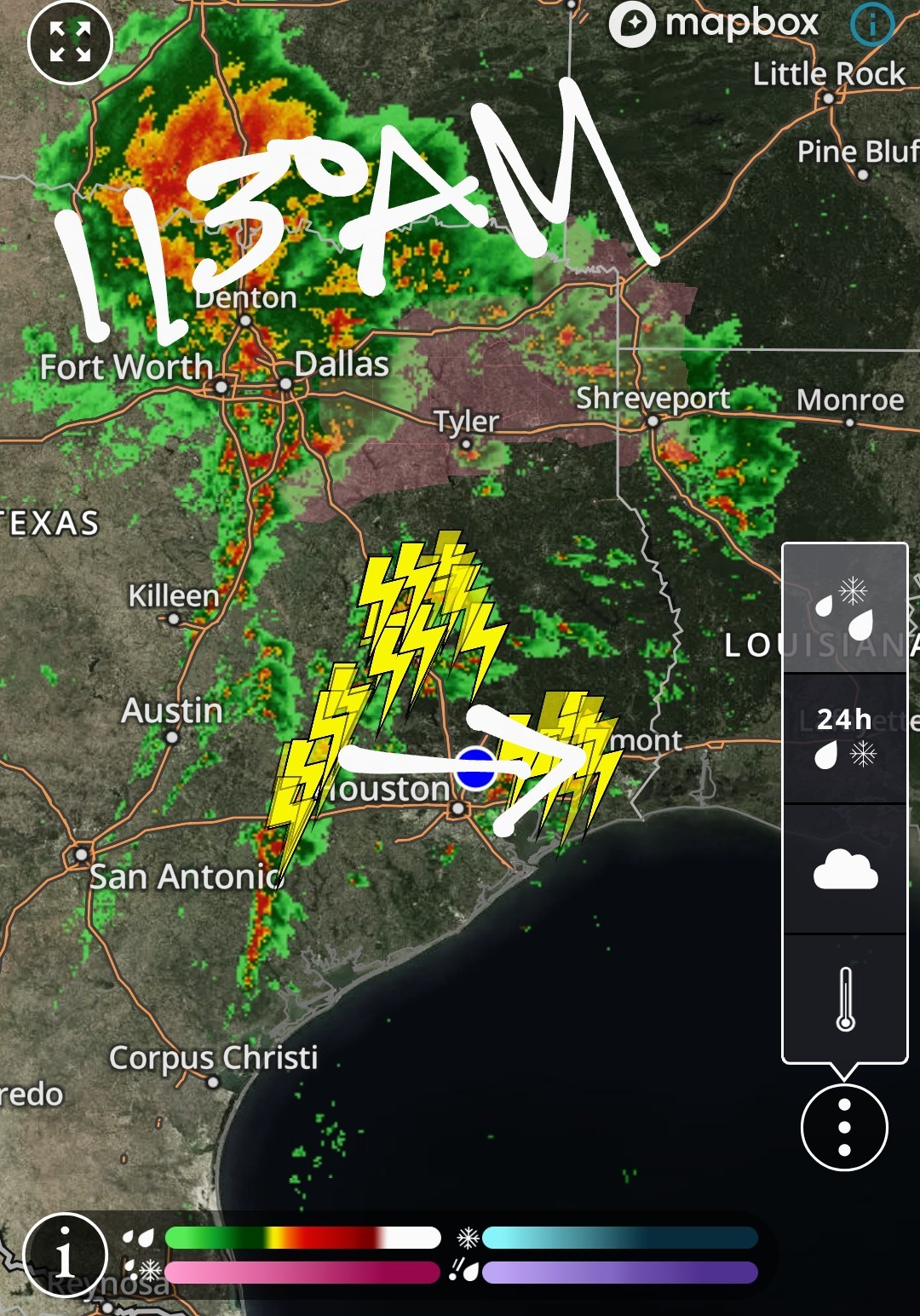 Future radar 3pm:
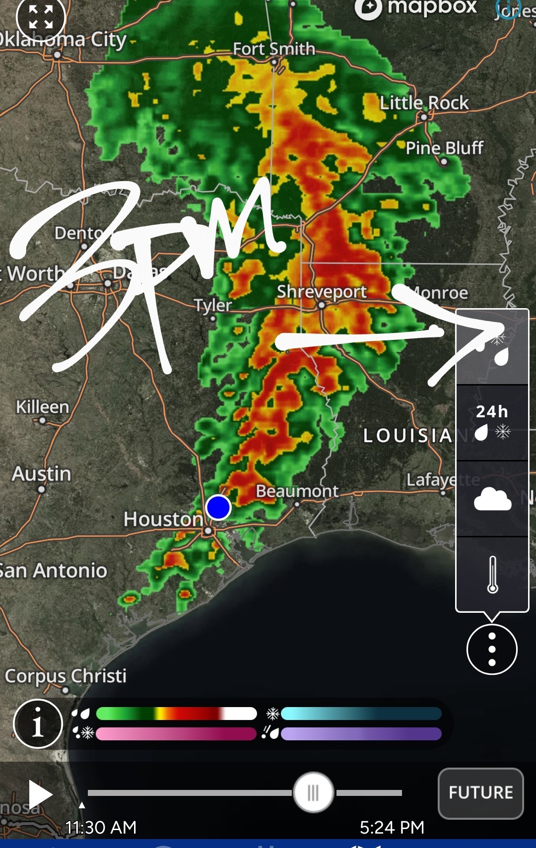 2" hail reported in some of these cells with some rotation so be aware. It looks like now until 6pm bears watching.
« Back to Chat
Views: 5,428
# Replies: 77